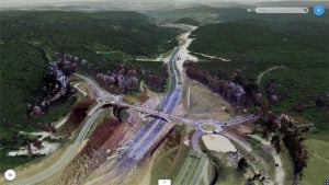
Trimble Clarity features cloud integration and support for 3D point cloud, imagery and mesh model formats. (Photo: Trimble)
Trimble’s browser-based viewer Trimble Clarity is now offered as a stand-alone web application, designed to simplify the visualization and navigation of 3D data.
According to the company, Trimble Clarity enables geospatial professionals to view, use and share 3D point cloud data, models and meshes with engineers, architects, city planners and other project stakeholders via a web browser, which can be viewed on desktop and mobile devices.
The Trimble Clarity web application allows users to generate private or public web links to share project information and 3D data. It also supports data from Trimble products, such as the Trimble SX10 scanning total station, Trimble TX Series 3D scanners and Trimble MX9 mobile mapping system, as well as data from non-Trimble sources.
In addition, with the upcoming version of Trimble Business Center office software 5.20, users can publish their 3D data directly into Trimble Clarity, creating a seamless integration and workflow between both platforms. Trimble Clarity provides a visual directory, which allows users to view 3D data as location-based projects.
Trimble Clarity also features cloud integration and support for 3D point cloud, imagery and mesh model formats.
“Trimble Clarity enables users to easily share and view rich 3D point clouds without having to transfer, copy or mail large data sets,” said Tim Lemmon, marketing director of Trimble Geospatial. “By leveraging an intuitive, browser-based experience, stakeholders can easily visualize and understand project data, enabling greater collaboration and informed decision making.”