Publicerad den Lämna en kommentar

New approaches improve PNT resilience

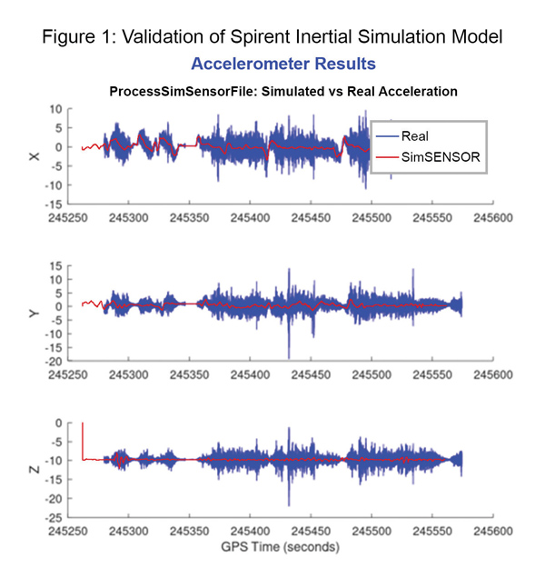
Data shows how successful baseline validation testing of Spirent's inertial simulation model as compared to real world inertial system performance. Photo: Spirent Federal Systems

Data shows how successful baseline validation testing of Spirent’s inertial simulation model as compared to real world inertial system performance. Photo: Spirent Federal Systems

We discussed complementary PNT with Roger Hart, head of engineering and Jeff Martin, head of sales at Spirent Federal.

What are some of the most promising approaches to complementary PNT sources and how does simulation technology help?

Roger Hart: The vulnerabilities of GNSS have been recognized. Legacy GNSS are all operating on pretty much the same frequencies and power levels, so, they have some significant common vulnerabilities. There is great interest in finding ways to complement or even replace those capabilities.

Dead reckoning, magnetic and inertial systems have been around for a long time. There are emerging markets to make use of alternative radio frequencies for navigation. In some cases, we are piggybacking on communications signals and deriving PNT from them. In other cases, we are using new PNT signals. A couple that we’ve been focusing on are the alternative navigation systems.

They may be using different orbits, different frequencies, different encoding schemes that set them apart from the legacy GNSS systems, so that, used together, they provide greater resiliency and even stand alone when one or the other system may be affected by interference.

Not to be forgotten is inertial navigation. It’s been around for a long time and is still a standard of navigation. Together with GNSS, it makes it a terrific navigation system. It almost defines complementarity because where GPS is vulnerable inertial can fill in the gaps and where inertial drifts GPS does not. So, paired, they make a very strong system.

At Spirent, we’ve been working with customers to provide a variety of options for both those alternative navigation systems and inertial. Both are a very active field of development and we’re keeping abreast of that.

Jeff Martin: Some good points, Roger. This is something we’ve been engaged in for quite a long time. Since we provide test equipment to the community, it’s critical that we understand what they’re worried about, what the vulnerabilities are. It keeps things exciting, it keeps us on our toes and looking ahead to what’s coming.

What are some of the remaining challenges of integrating GNSS receivers with inertial sensors and, again, how does simulation technology help with that?

Hart: Inertial works by integrating sensor measurements that come in. Therefore, any errors that are present just accumulate over time and can corrupt your navigation solution. So, there’s a strong focus on updating error models and on translating them so that everyday users can use them and get real-life-type performance out of them.

There’s a tendency to think of integrating GPS-INS as putting everything together in one box. There are packages that do that. However, the push now is to go to more distributed systems that are integrated but not packaged in the same box. One example is the all-source positioning and navigation standard that is being developed by the Department of Defense. It will allow you to swap one sensor for another as long as they adhere to the standard. That information all goes back to a sensor fusion engine.

Martin: We have known GNSS simulators well for about four decades. We have been playing in the inertial sandbox for at least a couple of decades as well. This has given us the opportunity to build relationships with the with the key manufacturers and designers of inertial systems. Those relationships have been expanding well beyond inertial to many other sensors and systems that are now coming online. It’s been exciting.

Much work is going into using low Earth orbit satellites for PNT—whether piggybacking on the Iridium satellites or launching new ones. How does simulation help with that?

Hart: It certainly helps with the development of the receivers. The groups that are using these alternative RF and LEO or MEO systems need simulation as they develop the receivers. It gives you the ability to try things certainly before you launch them. At this conference there is considerable interest in making things reprogrammable. We have the NTS-3 satellite, which will be running experiments for different waveforms that can be generated. Even M-code is a step in the direction of giving more flexibility to the signal. It has a lot more flexible cryptography and signal generation than the legacy system with the C/A and P/Y codes.

Our simulation platforms are software based, so we can generate and receive data that can be useful for developing software-defined receivers. It gives you the opportunity to try different waveforms. We have already delivered a satellite-based alternative navigation system simulator. Now, we can build on that one to help the other Leo constellations as they come forward.

Martin: Roger put it well. This is where things get fun. People are concerned with PNT vulnerabilities, so we’re seeing these alternative navigation solutions coming forward. Spirent has done a good job over its nearly 40 years of existence of manufacturing and designing its own hardware and software. It has given us the opportunity to respond quickly. These things are coming fast. People need solutions quickly. We have some solutions already and the platform that we have created gives us the flexibility to develop more. We’re seeing more and more ideas come to fruition and people need to test them. So, this is where it gets fun. We’re excited.

Much work has gone into addressing the enduring challenge of urban canyons. How does simulation technology help?

Hart: Urban canyons are the worst nightmare for GNSS signals. If you’re surrounded by tall buildings, signals are blocked. You may have few or even no satellites in a direct line of sight and many multipath reflections. So, diminished and corrupted signals are available to you. Of course, the more GNSS satellites you have, the better chance you have of getting good signals. But complementing that are radar and vision systems. Those are the ones that will stand out, particularly the vision systems that can read the street signs, see where the curb is, look for parked cars. All those kinds of things will help fill in when you have poor GNSS coverage.

You can observe what’s going on in the environment and simulate it. You can also use our forecasting tool to look ahead.

Martin: This is where things get exciting, isn’t it? In these terrible environments where GNSS is contested—whether it’s an urban environment or one with intentional jamming—there is a lot we can do to help our industry. When this happens in real life, it’s bad news. But when you create that scary situation in the controlled environment of a laboratory, it is great. You can pick things apart and see where you need to improve. I get excited about it. It’s probably the geek in me. It gives us and our partners a lot to look forward to.

How does simulation technology help with sensor fusion?

Hart: It definitely helps you put all the pieces together. You can’t know how your system will work by individually testing each piece. System is the key word here. Simulation enables you to generate the signals and bring them together into a sensor fusion engine. You can test different algorithms. It’s certainly much cheaper and quicker than trying to build this into a product and then test it. Over the decades, simulation has proved itself as a very valuable way in both basic development and integrating the final product.

Martin: That system-wide fusion is where the magic happens.

It sounds like simulation technology—and Spirent Federal in particular—are very much at the center of a lot of the current developments and discussions about complementary PNT. Do you have any final comments?

Hart: As Jeff said, it’s an exciting time. There are many things going on—new technologies, new ways of communicating. It’s a busy time and a bit of a scramble sometimes to keep up with all the new things that are coming.

Martin: People look to Spirent to be their testing resource and it puts us right in the middle of it.
Publicerad den Lämna en kommentar

Companies discuss navigation solutions at NAVISP Industry Days

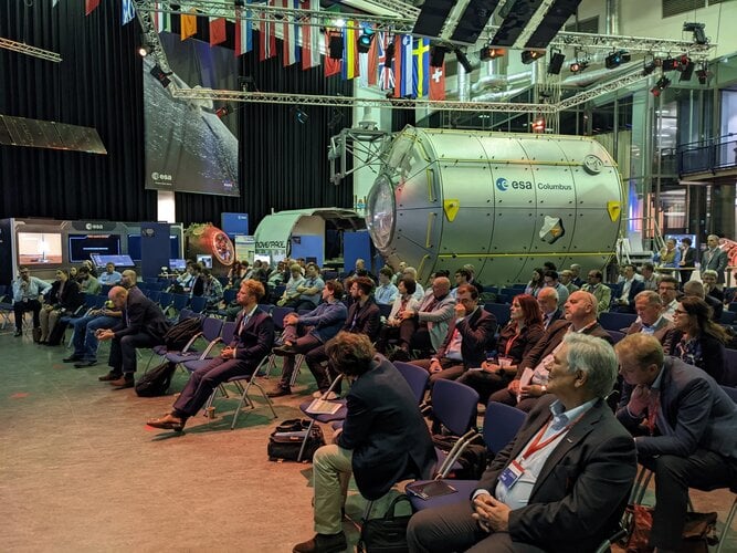
Europe’s leading companies and research institutes working on positioning, navigation and timing (PNT) technologies met in the Netherlands in mid-June for this year’s NAVISP Industry Days. The event is devoted to the latest developments in the Navigation Innovation and Support Program (NAVISP), sponsored by the European Space Agency (ESA).

NAVISP is focused on navigation technologies beyond Galileo and EGNOS, with many of the same engineers that led the development of Europe’s own satnav constellation working with European industry and academia on exciting new concepts.

Photo: ESA

Photo: ESA

About 130 people participated in the two-day event, which took place June 16-17 at the ESA-ESTEC center in Noordwijk aan Zee, The Netherlands.

As well as attending presentations on NAVISP projects, participants had the opportunity to meet and talk shop in the exhibition area, which displayed products and hardware such as an improved-accuracy smartphone board and drones for data gathering.


The PNT sector accounts for 10% of the European economy.


Throughout Industry Days, the importance of innovation for competitiveness was highlighted, to enable companies to adapt to rapid technological change in the fast-growing PNT sector, which today accounts for 10% of the European economy.

“NAVISP’s strength lies in supporting all types of actors, from start-ups and SMEs to large enterprises, and space companies to companies in other sectors that have recognized the added value of PNT solutions,” said Pierluigi Mancini, NAVISP program manager. “That means playing a part in advancing research and product development, as well as commercialization to broadly foster and support European industry in addressing technology, market and regulatory risks.”

At the Industry Days, many different projects across varying market areas along different points in the value chain were highlighted such as air mobility testbeds, new technologies for roads and other infrastructure, support for maritime navigation, development of novel PNT satellites, studies for quantum-based PNT, and weather monitoring based on collaborative crowdsourcing.

The innovation potential of NAVISP activities was underlined by the fact that two new Navigation Directorate programs set to be proposed to ESA’s Council of Ministers this November — the in-orbit demonstration of low-Earth orbit PNT services and the GENESIS mission for precision Earth measurement — originated in NAVISP projects.

The entire set of the NAVISP Industry Days presentations can be found here.

Publicerad den Lämna en kommentar

5G LBS features verified on R&S TS-LBS test solution

Photo: Rohde & schwarz

Photo: Rohde & schwarz

Rohde & Schwarz and MediaTek have verified new location-based services (LBS) features for 5G new radio (NR), which are now available on the R&S TS-LBS test solution.

The features will improve emergency caller location and support LBS-related use cases in challenging indoor and outdoor environments with both satellite-based and terrestrial technologies. The R&S TS-LBS now support these and other 3GPP Release 16 network-based positioning features.

A 5G chipset from MediaTek also has been verified for Release 16, which ensures the chip’s  positioning features.

The two companies verified the NR positioning reference signals (NR-PRS), which are central to network-based positioning features such as round-trip time (RTT), time difference of arrival in uplink and downlink (UL- TDOA and DL-TDOA), or angle of arrival and departure (AoA and AoD), and which meet the 5G requirements for indoor and outdoor positioning use cases.

With R&S TS-LBS supporting these features, mobile device and chipset manufacturers as well as test houses and network operators can carry out verification for GCF, PTCRB and network-operator certification using a single test solution.

About the R&S TS-LBS System

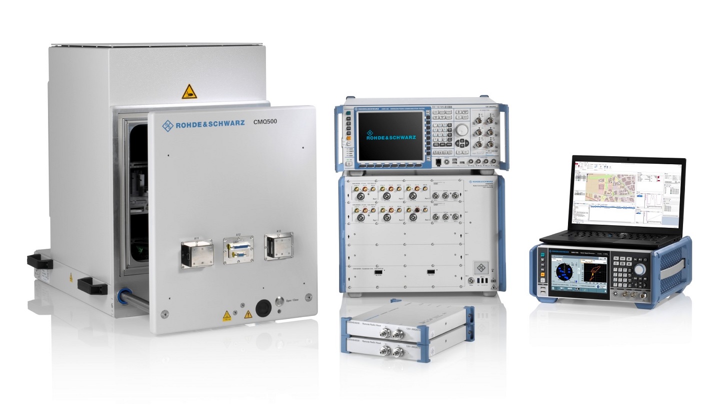
The R&S TS-LBS is a test system for testing GNSS and network-based positioning. It consists of an R&S CMX500 OBT one-box signaling tester as the network simulator and an R&S SMBV100B GNSS simulator.

The R&S CMX500 OBT setup provides full network simulation capabilities including the support of multiple 4G or 5G cells at a time. In addition, it provides LBS assistance data to the DUT while the R&S SMBV100B simulates the GNSS satellites.

The R&S TS-LBS test system can be used for pre-conformance tests and to obtain GCF and PTCRB certification as well as network-operator-specific certification acceptance and validated tests.

“Adding network-based positioning features such as DL-TDOA based on NR-PRS to the existing satellite based location signals shows the advanced level of our test solution,” said Christoph Pointner, senior vice president, Mobile Radio Testers, Rohde & Schwarz. “We are happy to continue our collaboration with MediaTek to push 5G location-based services further for 3GPP Release 16.”

Publicerad den Lämna en kommentar

InfiniDome records GPS jamming mitigation at Israel-Syria border

Photo: InifiDome

Photo: InifiDome

InfiniDome has conducted testing and measurements in the Golan Heights along the Israel-Syria border. The goal of the tests was to hunt down jamming events, record them, see how they affect both protected and unprotected receivers, and then compare the results.

Two identical u-blox M8N receivers aboard a UAV were tested side by side, with one protected by GPSdome technology.

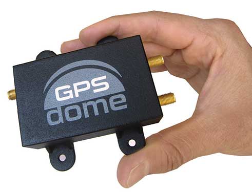
The GPSdome anti-jammer is a retrofit module that can be easily integrated to protect any GNSS-based system. It combines patterns from two omnidirectional antennas to create a null in the direction of the jamming signal, thus attenuating its power, making any GPS receiver about 50 times more resilient to jamming.

In a video of the tests, the GNSS receiver protected by GPSdome can be seen maintaining the GPS signal along the border, enabling uninterrupted navigation.

In contrast, the unprotected GNSS receiver loses the GPS signal during the attack, which can easily result in the drone becoming completely jammed, aggressively drifting and eventually crashing.

The Israel-Syria border experiences frequent jamming from Russian forces positioned in Syria, affecting critical border surveillance operations in the Golan Heights. Other global hotspots for jamming include the U.S.-Mexico border, where drug cartels use jammers on U.S. border surveillance drones, and the Shanghai port in China, where pirates may be the cause of ship and plane navigation confusion through use of jammers.

Jamming in Ukraine has also been well documented, with attacks from Russian forces taking down any plane, drone and even critical infrastructure asset in proximity, according to infiniDome.

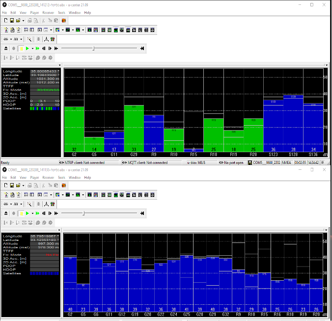
Two screenshots of recordings during the event: The top image is of the GNSS receiver (u-blox M8N) protected with the GPSdome, ensuring continuous navigation. The bottom is unprotected and shows how the M8N was completely blocked for the entire route. (Images: InfiniDome)

Two screenshots of recordings during the event: The top image is of the GNSS receiver (u-blox M8N) protected with the GPSdome, ensuring continuous navigation. The bottom is unprotected and shows how the M8N was completely blocked for the entire route. (Images: InfiniDome)

The jamming attack was analyzed and appears not to have been a brute force attack, but rather a slightly more sophisticated signal, causing the receivers to “see” satellites but not be able to sync their signals and track them. The receiver protected by the GPSdome was able to distinguish between the real GNSS signals and the jamming signals.

In addition, GPSdome was able to attenuate the jamming signals sufficiently to be able to continue tracking the real GNSS signals while at the same time reporting the attack via its dedicated alert output.

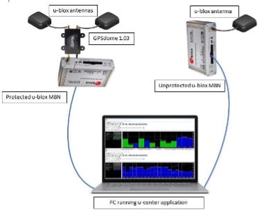
Because GPSdome is both lightweight and easy to integrate (see integration diagram below), it can effectively provide much-needed resilience to drones and UAVs from widely available jammers, enabling drone operators to carry out missions safely and reliably.

GPSdome integration. (Image: InfiniDome)

GPSdome integration. (Image: InfiniDome)

Publicerad den Lämna en kommentar

How TerraStar is meeting the growing demand for correction services

Interview with Sara Masterson, Director, Positioning Services, Hexagon’s Autonomy & Positioning division, Hexagon | NovAtel

Photo:

Sarah Masterson, Hexagon | NovAtel

The accuracy of GNSS receivers continues to increase thanks to new satellites and signals, improved antennas, etc. How is that changing the role of correction services?

For sure, the accuracy of GNSS receivers and antennas is improving. However, most applications still require a higher level of accuracy than what is available from an uncorrected position even with the positioning improvements brought by new constellations and signals. GNSS corrections are still required to enable, say, lane-level accuracy, or sidewalk-block accuracy for autonomous driving or mobile phone applications and for off-road autonomy applications such as construction, mining, agriculture — these all still require centimeter-level accuracy that is enabled through GNSS correction services.

Corrections also help by improving the availability and reliability of a solution. In the future, corrections will play a key role in adding integrity to enable functionally safe solutions that are required for new applications, such as autonomous driving.

There are many options for corrections — local, regional and global, ground-based and satellite-based, public and private, etc. Which of them are generally best for which applications and conditions?

That depends very much on the user and the application. There are many new correction services in the market. Some are free, some are commercial services. Even now we see in agriculture that WAAS is sufficient for some broadacre-type applications. So, we will continue to see a range of applications, some of which will be satisfied with the level of performance from a free service and others that will be looking for the better performance and service level guarantees that come with commercial services.

If something is not working when you are using a free service, there’s no one to call. With commercial services, you get responsive customer support and you pay for higher levels of performance and service availability. In many applications, especially those that involve autonomy or safety applications, you cannot afford to have downtime, or your machine just stops working, which costs money. So, many applications are still going to be needing the performance and service level guarantee that commercial services offer.

How does TerraStar fit into this range of options? What industries and applications are you targeting?

TerraStar has a range of services that enable us to target many industries and applications. Agriculture, of course, is one of the key applications for our services and we have customers using TerraStar for mobile mapping, UAVs and new autonomy-based applications. We are also involved with some interesting Hexagon joint projects that use TerraStar corrections for mine train automation and surveying and construction.

Our entry-level TerraStar-L service is still better in performance to many of the free services or to an SBAS-type service in terms of accuracy, but it is available globally, including regions where you don’t have other options. It also provides better pass-to-pass and year-over-year repeatability, as well as very quick reconvergence time if there are any issues with GNSS outages.

Our flagship offering is the TerraStar-C PRO service. That’s where we just introduced the “RTK from The Sky” technology, bringing the performance down to converging to two and a half centimeters in three minutes. That, too, is available globally which makes it a real game changer for customers in many different applications, because they can start to look at that service as an alternative to RTK and without the added connectivity logistics that an RTK solution brings.

Our RTK assist solutions are good augmentation solutions for customers who still primarily need RTK but experience some RTK correction outages – RTK ASSIST bridges through those outages. So, we have a wide range of service offerings in the portfolio that can address the positioning needs of many applications.

A Massey Ferguson tractor guided by a NovAtel GNSS OEM receiver. (Photo: Hexagon | NovAtel)

Photo: Hexagon | NovAtel

Will the reasons for having a base and rover setup decrease sharply?

Use of base and rover setups is already decreasing and being replaced by both PPP and network RTK solutions. There are applications where RTK still makes sense, such as those that have very tight vertical requirements and many survey applications. Another Hexagon division, Hexagon’s Geosystems division, incorporates TerraStar correction data into their new SmartNet Global offering as a seamless service that provides both SmartNet RTK plus TerraStar for either bridging outages or independent PPP operation, depending on the project’s location and whether they’re within range of SmartNet coverage.

There will be many applications that continue to benefit from a combination of the two technologies. However, as the PPP services, like TerraStar, continue to improve by reducing convergence time and providing highly reliable solutions, users in those applications can be confident that the standalone PPP solutions meet their performance needs and bring many additional benefits such as consistent, global coverage and performance.

Is TerraStar completely receiver agnostic?

TerraStar is currently only compatible with NovAtel’s GNSS hardware. Going forward, through the work that I referenced with autonomous driving and mass-market applications, we will be providing TerraStar services in industry-standard formats, depending on the inter-operability requirements coming from those applications. We expect that there will be demand for dual sourcing of corrections and interoperability between chipsets that are used in vehicles, for example. For those applications, we will be developing TerraStar services that are compatible with hardware from other GNSS manufacturers.

Publicerad den Lämna en kommentar

Semtech launches LoRa Cloud Locator service for asset tracking

New service demonstrates the asset-tracking capabilities of LoRa Edge ultra low-power geolocation platform

Image: Semtech

Image: Semtech

Semtech Corp. has announced its LoRa Cloud Locator service, which uses Semtech’s LoRa Cloud modem and geolocation services.

The new service gives customers the opportunity to experience devices powered by LoRa Edge and evaluate the accuracy and power consumption of the LoRa Edge platform, which offers an ultra-low power and cost-effective solution for indoor/outdoor asset tracking.

LoRa Cloud Locator features built-in serverless technology and delivers a simple end-to-end experience for customers to evaluate LoRa Edge implemented in various ecosystem trackers, either on a private or public LoRaWAN network.

“Asset tracking is one of the most common use cases across industry verticals,” said Karthik Ranjan, LoRa Cloud solutions and partnerships leader in Semtech’s Wireless and Sensing Products Group. “Whether it’s tracking wheelchairs in a hospital, shopping carts in retail, pallets in supply chain, cattle in agriculture, or pets around a home, asset tracking can be found everywhere. Semtech’s LoRa Cloud Locator is the fastest way for customers to easily see for themselves the benefits offered by purchasing trackers with LoRa Edge, provisioning them onto the application and seeing their location on the map.”

LoRa Cloud Locator is designed specifically to work with trackers using Semtech’s LoRa Edge LR-series chips with minimal effort. Once configured on the service, together with Semtech’s LoRa wireless radio frequency technology for transmission to the cloud, customers can view the tracker location on the map in less than 15 minutes.

“Semtech’s LoRa Cloud Locator is the most efficient and fast way to evaluate the LoRa Edge platform as it can measure the performance of the technology and differentiate when a device is tracked by GNSS or Wi-Fi,” said Maximiliano Ruiz, founder and CEO at Galileo RTLS. “With the Wi-Fi location feature, we can now receive GNSS signals without paying for the prohibitive power consumption of traditional GNSS technologies. Through leveraging LoRa Edge, locating assets around the world is much simpler with the unprecedented years of battery life.”

Publicerad den Lämna en kommentar

Swift Navigation to provide South Korean telecom with precision positioning

Swift Navigation logoKT Corp., a major South Korean telecommunications company, has partnered with Swift Navigation Co., a San Francisco-based technology firm, to commercialize an ultra-precision location data service, reports The Korea Economic Daily.

The companies on June 29 signed a precise-positioning business partnership agreement that KT hopes will enable precision location services for autonomous vehicles, drones and urban air mobility.

Swift Navigation’s precise-positioning platform improves location accuracy from several meters to centimeters, enabling safer driving, improved efficiency for last-mile delivery and commercial transport operations, and enhanced accuracy for mobile devices.

Publicerad den Lämna en kommentar

ADVA unveils high-performance optical cesium clock

Service providers harnessing the solution can now offer GNSS/GPS- backup-as-a-service (GBaaS) with enhanced precision and availability

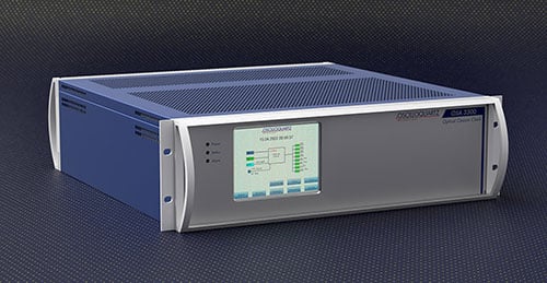
OSA 3300-HP. (Photo: ADVA)

OSA 3300-HP. (Photo: ADVA)

ADVA has introduced its Oscilloquartz high-performance optical cesium atomic clock. The coreSync OSA 3300-HP is ADVA’s latest innovation in assured positioning, navigation and timing (PNT).

Following ADVA’s launch of an optical pumping timing solution two years ago, the OSA 3350 ePRC+, the OSA 3300-HP takes the technology to new levels. It has a 10-year lifetime compared to the five years offered by currently available high-performance magnetic clocks.

As a high-performance optical cesium clock, the OSA 3300-HP sets a new benchmark for precision and availability, ADVA claimed, providing the resilience required for PNT assurance in critical infrastructure and empowering service providers to deliver differentiated service-level-agreement timing offerings with integrated GNSS backup.

The feature-rich device has embedded Ethernet- and IP-based management as well as a user-friendly touchscreen graphical user interface.

“The launch of our coreSync OSA 3300-HP marks a key milestone in the design of atomic frequency and phase standards,” said Gil Biran, GM of Oscilloquartz, ADVA. “After many years of extensive work in our Swiss laboratories supported by the European Space Agency, we now have a mature, state-of-the-art technology that enables a major leap in the accuracy and stability of network timing while providing a substantially longer lifetime.”

Atomic clocks offer synchronization backup for networks that rely on GNSS-based timing, combining high accuracy with outstanding availability. The OSA 3300-HP commercial high-performance optical cesium atomic clock features an all-digital design and leverages optical-pumping techniques using laser diodes. This enables it to measure 100 times the number of atoms, making it more efficient compared to existing primary reference clock (PRC) technologies.

Publicerad den Lämna en kommentar

Report: ‘What on Earth Is the Value of Space?’

Image: Inmarsat

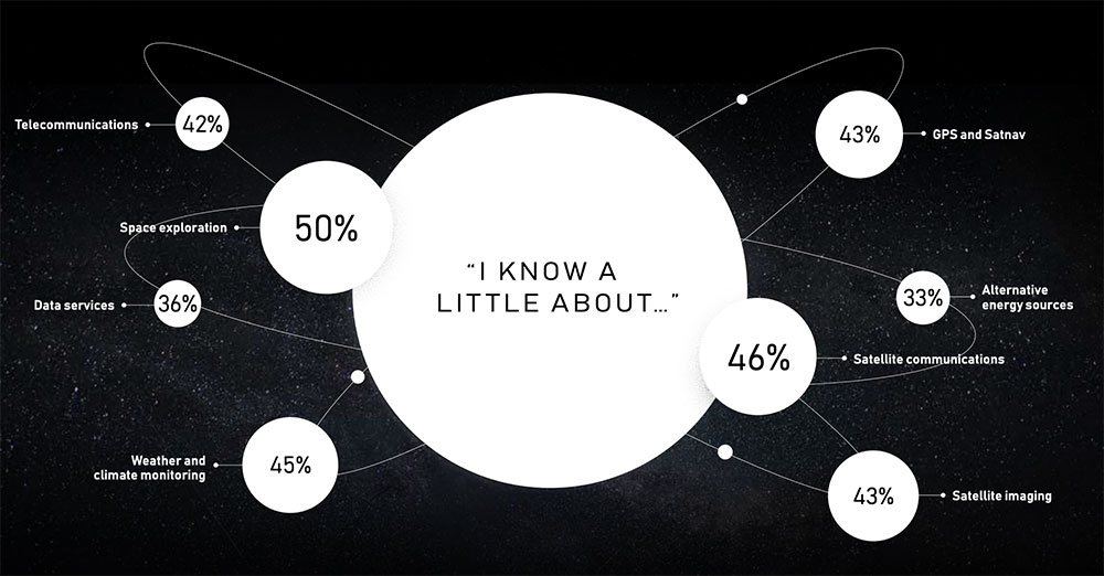
Almost half of respondents are aware of GPS and satellite navigation. (Image: Inmarsat)

Inmarsat has launched a report “What on Earth is the value of space?” that surveys public attitudes towards space.

The satellite company spoke to 20,000 people in 11 countries across the globe to uncover their perceptions of space, what happens “up there” and how they think it impacts life here on Earth.

The survey found that most people have no idea about the benefits of space. Only one third are excited about space, with 47% concerned about space junk and just 8% associating space with communications and connectivity.


Just 8% of respondents associate space with communications and connectivity.


“From connecting rural communities to helping solve climate change, we know the enormous potential space holds to improve life on Earth, and what it has already brought us,”  Inmarsat said in a statement. “Now, both the magnificent possibilities and the potential risks of space, which Inmarsat is working hard to address, need to be showcased to the world.”

The report also features contributions from renowned figures in the sector including Scott Kelly, former astronaut and commander of the International Space Station, and Josef Aschbacher, director general of the European Space Agency.

“The research findings mark a real wake-up call for the space industry,” Inmarsat said. “It’s clear that people have a low understanding of the breadth and richness of the work being done in space today. Perhaps because the technology deployed is essentially invisible, people do not appear to understand the role space is already playing in their everyday lives, nor its potential to deliver a brighter future for our planet.”

Publicerad den Lämna en kommentar

ComNav launches GNSS high-precision positioning for lawn mowers

ComNav Technology now provides a GNSS high-precision positioning solution for navigation and positioning of autonomous lawn mowers. Environmentally friendly and intelligent robotic lawn mowers are growing more popular, making the mowing task easier, safer and more convenient.

R&D background

It is difficult to develop autonomous lawn mowers because they obtain navigation information by means of visual and acoustic sensors, usually through embedded cables in the working area and detection through eddy current sensors. The shortcomings are obvious: before the mower starts, it must be set up with cables and other equipment. Cable requirements differ in various countries, and cable laying can be complicated, wasting resources and money.

With these difficulties in mind, ComNav applied its K8 series of GNSS high-precision modules to lawn mowers to break through the application limit. It solved this accuracy problem to make the lawn mower achieve centimeter-level driving according to the setup path in an open field. With ComNav’s other technologies — quantum algorithm and LAI, HighLock, PPP, RTK-KEEP — the law mowers continues to operate under trees, around corners or in other obscured areas.

Introduction of ComNav’s solution

With the K8 series module, ComNav facilitates the lawn mower’s fieldwork with position data provided by GPS, GLONASS, Galileo, Beidou, QZSS, IRNSS and SBAS.

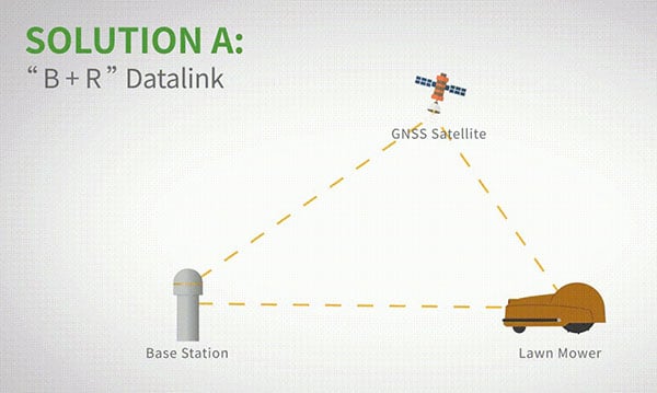
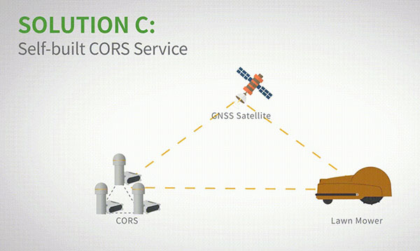
The high-precision positioning system for lawn mowers consists of a base station and a rover station. Three solutions are recommended for the terminal to obtain differential data from the base station.

Base and rover datalink. A base station acquires differential data through a datalink and provides corrections to the rover. The rover station — comprising the parts installed on the lawn mower, including the GNSS antenna, the GNSS high-precision module, datalink and UHF antenna — enables centimeter-level positioning and navigation.

Image: ComNav

Image: ComNav

Local CORS network. Utilizing existed local CORS, the rover station obtains differential data from the CORS service, enabling the lawn mower to achieve positioning and navigation accuracy on a centimeter level.

Image: ComNav

Image: ComNav

Self-built CORS network. Base stations can be placed anywhere based on requirements. Doing so eliminates the worry about prevailing conditions and makes high-precision positioning and navigation of lawn mowers possible.

Image: ComNav

Image: ComNav

Technology Features

LAI technology. ComNav’s patented low-power anti-interference (LAI) technology provides a jamming-to-signal ratio of up to 50 dB. Power consumption is only 0.1 W when turned on. By quickly detecting and eliminating interference with simple settings, LAI technology can reduce failure time and ensure safe operation. The technology can generate a spectrum diagram of interference sources, enabling identification of interference types and potential interference sources.

Quantum algorithm. ComNav’s quantum algorithm has sophisticated technology for detecting and repairing cycle slips. It uses full-constellation and full-frequency tracking capabilities along with multi-frequency combination, model and parameter estimation. Quantum is able to eliminate errors caused by the ionosphere, the troposphere and multipath in seconds. As a result, the initialization time of real-time kinematic (RTK) is greatly shortened and precision and reliability are improved. Meanwhile, the extra-long baseline calculation capability expands the operation range.

RTK-KEEP technology. By estimating model and parameter values, RTK-KEEP Technology can reduce errors caused by satellite orbit, clock difference, ionosphere and troposphere when the base station’s data is lost. Centimeter-level accuracy can be kept for more than 10 minutes, greatly improving the availability of RTK.

Benefits of ComNav’s Solution

ComNav’s solution allows the lawn mower to achieve centimeter-level positioning and reduce mowing repetitions. It helps the lawnmower to operate safely and reliably in the corners, under trees, or in other places where satellite signals are weak or lost. With its strong anti-interference capabilities, the lawn mower can maintain continuous and effective positioning in complex environments, meeting the needs of a variety of applications.