Funding continues to flow into companies developing and testing electric vertical-takeoff-and-landing (eVTOL) drones — both piloted and unpiloted. Plus, the potential for clearing landmines using drones is being investigated by a team at Oklahoma State University.
Air taxis advance with funding
In early September, United Airlines committed to a $15 million investment in Eve Air Mobility, giving the air taxi industry another shot in the arm. The deal includes a conditional purchase of 200 and an additional 200 in options for Eve’s semi-autonomous four-passenger eVTOL aircraft. The investment is one of United’s efforts toward its goal of net zero carbon emissions by 2050.
Eve Air Mobility is partnered with Embraer, the Brazilian aircraft manufacturer guiding Eve’s path to first eVTOL aircraft certification under the National Civil Aviation Agency of Brazil (ANAC). Subsequent approval by the U.S. Federal Aviation Administration (FAA) and the European Union Aviation Safety Agency (EASA) would then be based on the Brazilian ANAC certification program, following in the path of U.S. and European approvals of the Embraer EMB/ERJ series of passenger aircraft.
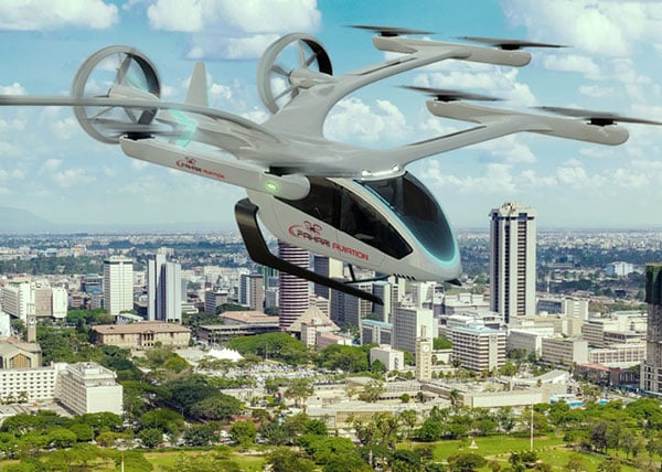
The Eve eVTOL air taxi. (Image: Eve Air Mobility)
Eve and parent Embraer also have announced a deal with BAE Systems to design an eVTOL aircraft for military and security applications. The technical details of the UAV/aircraft have been kept carefully under wraps, save for the visible use of eight lift rotors and two ducted fans for forward flight. Flight management computers, guidance, air-data, altitude sensors and high-integrity communications would likely be included in the avionics suite.
Meanwhile, United’s prior investment in Archer Aviation and its Maker eVTOL appears to be supporting the Maker’s progress along the road to civil certification. Maker flight tests so far have apparently been limited to vertical flight; its multiple lift and tilt-rotor design has yet to be tested in transition to forward flight.
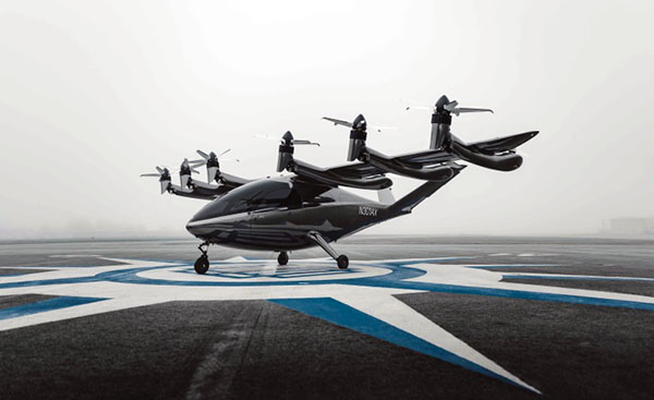
The Maker eVTOL air taxi. (Image: Archer Aviation)
Nevertheless, more information appears to be available on the configuration of the Maker eVTOL. The company’s approach is to demonstrate early on that safety is a major driver for the design, with significant redundancy in the vehicle’s systems. The Maker has four flight-control computers, plus redundant control and navigation with inertial navigation, GNSS and above-ground-level (AGL) sensors, both radar and laser altimeters. Redundant communication links between sensors, flight-control computers and actuators combine to provide another level of design safety. The vehicle has six lift rotors at the back of the wing, plus an additional six main tilt-rotor lift and thrust rotors — another significant contribution to redundancy.
In January 2021, Archer said that United Airlines ordered 200 Maker aircraft for $1 billion with an option for more aircraft worth $500 million. Archer also just got another healthy financial injection in August with United’s pre-delivery commitment of $10 million for 100 Maker-type aircraft.
There are numerous eVTOL builders around the world. Several of note include Boeing/Wisk (U.S. and New Zealand), Joby (U.S.), Vertical Aerospace (UK), Ehang (China), Airbus (France), Lilium and Velocopter (both Germany) and Beta (U.S.).
Drones help detect landmines
Its difficult to imagine the extent of the problem, but there are many, many areas of the world where landmines are a major hazard to civilian life. Eventually, wars move on or die out, with not only towns and infrastructure destroyed, but significant left-over hazards to reclaiming territory once occupied by the aggressors.
Landmines come in many flavors, but most are deadly and most kill or maim innocent people coming across them. Unexploded bombs, mortar shells and the like also can kill and hurt people, especially children. Apparently, 50 to 60 countries around the world have areas where landmines or unexploded ordnance pose a threat to civilians.
The good news is that several organizations around the world have been using drones to survey areas suspected of being mined. The organizations send drones equipped with magnetic detection sensors a few inches above the ground. The drones geotag mine locations, and those locations go into an area database. Then another drone is sent to drop a detonator on the mine location, with the mine later exploded from a distance.
An investigative team at Oklahoma State University is making an effort to train a drone-based machine-learning system to recognize various types of landmines and explosive ordinance. While the system isn’t aimed at detecting mines without human participation, it’s expected that drone recognition of mines could greatly improve current efforts to remove landmines, and quicken the pace at which the world can get rid of this plague of hidden explosives.
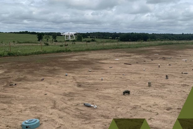
A drone flies over a grid showing 50 types of ordinance. (Photo: Oklahoma State University)
The research team is working in an area they have set up with inert mines of many types to train the drones to recognize the specific type of device and geotag the location. This isn’t artificial intelligence as such; it’s using drones to find an object and geotag it, while the network to which the drone is connected recognizes from the sensor data what type of mine the drone has found.
In the research phase, the team is feeding data into the network on lots of different types of mines and munitions, providing the network with a model for each type of ordinance and eventually enabling device recognition in the field.
_________________________________________________________________________
To sum up, the rush for air taxis to become a ubiquitous resource for city travel still wends its way through the civilian twists and turns leading to civilian certification for use, with many outfits working hard to build flying testbeds and investors funding their efforts.
Finding novel drone-assisted ways to clear the millions of landmines left over in wartorn countries is becoming a higher priority — notwithstanding Princess Diana’s efforts to draw attention to the suffering and death from landmines several decades ago. Let’s hope this goes somewhere soon.
Tony Murfin
GNSS Aerospace