Publicerad den Lämna en kommentar

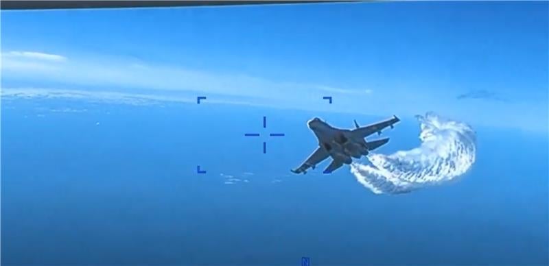
Russian fighter jet collides with UAV

Image: Screenshot of video uploaded by EUCOM

Image: Screenshot of video uploaded by EUCOM

An MQ-9 Reaper UAV has collided with a Russian Su-27 fighter jet after it tried to spray the UAV with jet fuel, reports ABC News. The U.S. European Command has released a video that was taken from a camera the bottom of the UAV and shows the moment the collision occurred.

The Russian fighter jet took two passes at the UAV. During the second attempt to spray the UAV with jet fuel, they collided. Communication with the UAV was lost momentarily after the collision.

From the video, one of the propeller blades of the UAV seems to be damaged.

As of now, there are no further updates.

Publicerad den Lämna en kommentar

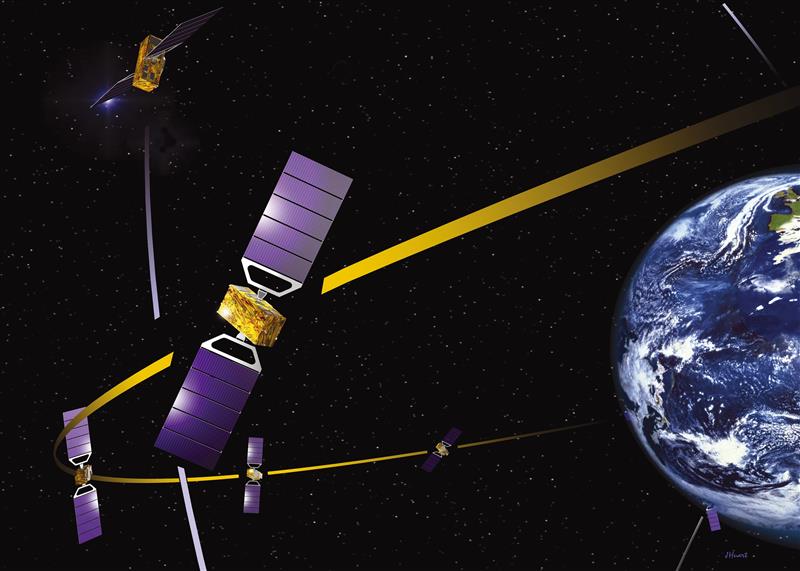
GMV to develop Galileo second-gen test bed

Image: GMV

Image: GMV

GMV has been selected by the European Space Agency (ESA) and the European Union Agency for the Space Programme (EUSPA) to develop the Galileo second-generation system test bed (G2STB). The G2STB will provide ESA with a key system verification and validation facility in support of its role as Galileo system development prime, enabling a wide range of Galileo system monitoring, troubleshooting, prototyping and experimentation activities.

GMV will deliver four G2STB versions over five years. Among these modules, the G2 high accuracy service (HAS) data generator and monitor aims to improve the Galileo HAS that was declared operational in January.

Other early capabilities of the G2STB include an upgraded orbit determination and time synchronization facility — capable of processing inter-satellite link data, a time service monitoring module, an integrity support message generator, a signal authentication service, an authentication validation module, an emergency warning service module, an ISL simulator and a G2G message composer.

The G2STB project aims for a smooth transition from the Galileo first-generation to the second-generation, building onto the G1G legacy system tools. The G2STB is one of the key infrastructure elements that ESA is developing for the correct functioning of the Galileo second-generation satellites.

The G2STB will eventually replace and upgrade the capabilities of the two first-generation facilities, the Galileo system evaluation equipment and the time and geodetic validation facility (TGVF-X). The latter, developed and operated by GMV over the last decade, has played a key role in monitoring the Galileo signals and system validation activities during the Galileo exploitation phase. The TGVF-X is also contributing to the early validation of new capabilities and elements being rolled out in recent and upcoming Galileo System updates.

In parallel to the development phase, the G2STB will help upgrade the network of Galileo experimental sensor stations to process new signals and capabilities to ensure the availability of a G2-capable, worldwide, multi-constellation network of receivers and bit-grabbers — independent from the operational Galileo sensor stations.

Publicerad den Lämna en kommentar

Editorial Advisory Board Q&A: How could the U.S. develop GPS high-accuracy analogous to Galileo’s HAS?

What would be required for the United States to develop and deploy a GPS high-accuracy service analogous to Galileo’s HAS?

Headshot: Ismael Colomina

Ismael Colomina

“Galileo HAS is a particular implementation of a PPP-RTK service. U.S. companies are already providing similar fee-based services that are even more accurate than HAS. Therefore, there is no big technical challenge for the United States to provide a GPS HAS. Actually, the European Union already provides a HAS for GPS. It is more a question of strategy for GPS policy makers: which user segment to service with a HAS-like augmentation? What about other services analogous to Galileo’s OSNMA and the upcoming CAS [commercial authentication service] for resiliency purposes? In short, a HAS-like service would just require including it in the U.S. GNSS evolution roadmap.”

— Ismael Colomina
GeoNumerics


Photo: Orolia

John Fischer

“The challenge is probably more political than technical. The U.S. government usually refrains from competing with commercial services. The prevailing attitude in the United States is that the private sector is more efficient than the public sector. Maybe the most practical approach is for the government to provide the authentication mechanism and open access to the data required, then allow the private sector to offer services. There isn’t a pressing need for high-accuracy GPS for transportation — it needs resiliency/reliability. However, precision agriculture needs it, so maybe sponsorship from the Department of Agriculture would be more effective than from the Department of Transportation.”

— John Fischer
Orolia


Mitch Narins

Mitch Narins

When I saw this question, my first impression (as a systems engineer) was to ask ‘For whom? For what applications? For which services?’ (Positioning? Navigating? Time/frequency?) Many have concentrated on accuracy, competing in a GNSS Olympics to see who can achieve ‘the best’ position accuracy and precision (repeatability). Finally, (thanks to Logan Scott) integrity is being pushed beyond just SBAS and GBAS, and real civil authentication of signals is being pursued. I can promise nanometers/nanoseconds if I don’t have to prove it’s true. While we finally understand the need for zero trust, we must still address loss of service by establishing real complementary PNT.

— Mitch Narins
Strategic Synergies

Publicerad den Lämna en kommentar

Furuno presents, exhibits at WSTS 2023

Furuno logo 2023Furuno will participate in the Workshop on Synchronization and Timing Systems (WSTS) 2023, on March 13-16 in Vancouver, Canada.

The exhibition brings together the leading corporate and government experts to shed light on the diverse innovation taking place in the field of synchronization and timing.

Furuno’s Takahiko Ikeda, general manager of research and development, Systems Products Division, will speak on time synchronization in his presentation, “The Contribution on the Accuracy and Robustness of Time Synchronization in Multi-Constellation and Multi-Band GNSS Receivers.”

In this presentation, Ikeda will explain how L5 receivers are effective in time synchronization applications and how they contribute to the safe and secure operation of critical infrastructure, showing specific test results.

Furuno will also introduce and exhibit its latest GNSS receivers and antennas for timing. The featured products include:
• Timing multi-GNSS receiver module GT-100
• Multi-GNSS disciplined oscillator GF-8801/8802/8803 and GF-8804/8805
• Field time sync generator TB-1
• Dual-band GNSS antenna

Publicerad den Lämna en kommentar

Winners announced from myEUspace competition

Image: EUSPA website

Image: EUSPA website

The European Union Agency for the Space Programme (EUSPA) has announced the winners of the first myEUspace track “Submission of an Idea.” This track consists of promising theoretical ideas that leverage EU space data and have high market potential. Winners received a cash prize of €10,000 each.

The myEUspace competition is open to teams from all EU Member States plus Switzerland, Norway and Iceland. The competition offers a total prize of nearly €1 million and provides support to entrepreneurs throughout the entire innovation cycle, from early-stage start-ups to scale-ups.

While the evaluation of the prototypes track is ongoing, the competition remains open for the last track, “Submission of Products.” Applications for the final track are due April 25.

Depending on the maturity of the solution at the time of submission, entrepreneurs can compete and win in three different innovation areas: “Space My Life,” “Our Green Planet” and “Dive in Deep Tech.”

See the full list of winners by area of innovation:

“Our Green Planet”
• Spillalert: Intuitive web interface for oil spills and blackwater tank detection
• BugBit: Risk analysis platform for predicting and alerting of bark beetle outbreaks
• Push4CleanAir: SaaS pollution monitoring platform
• Detritus: Online platform and mobile app for waste-crime detection
• Orioos: Autonomous robotic solution for monitoring woody perennial crops
• Vantu: Van-lifers companion app to discover “off the beaten track” sites to camp for the night

“Dive in Deep Tech”
• DeGenS: Decentralized space-to-ground data availability for artificial intelligence (AI) using blockchain
• Climate AI for Web3: Real-world portable climate API for virtual worlds powered by AI and satellite data
• Latitudo Supersar: AI analysis, classification and interpretation of multi-sensor and multi-mission images
• WhisperCash: Person to person payments via satellite for isolated regions
• Kyck: Geospatial metaverse platform for exploring and sharing AR experiences in the physical world

“Space My Life”
• Foremca: Cryptographic methodology providing forensic digital proof
• MicroPURA: Microbial Purity to detect levels of microbial contamination in the air
• Space4CC: Monitoring actions to safeguard cultural heritage in conflict areas
• Oasis City Lab: AI tool to track urban threats

Publicerad den Lämna en kommentar

First Fix: How high is the sky?

Matteo Luccio

Matteo Luccio

When the U.S. Air Force shot down a Chinese balloon flying at 60,000 ft (11.4 miles) on Feb. 4, the incident raised many questions about international security, international law, U.S.-China relations and technology. Among them, where is the end of a nation’s airspace — the portion of atmosphere it controls above its territory? Its horizontal boundary corresponds to that of its land border and territorial waters, which extend 12 miles out from its coastline. However, there is no international agreement on the vertical boundary.

The 1967 Outer Space Treaty — to which the United States is a party and which bans “appropriation” of outer space by any nation — omits a definition of “outer space” because none of the major powers wanted to limit their own freedom of action in space. At a United Nations meeting in Vienna in 2001, the U.S. delegation said, “Our position continues to be that defining or delimiting outer space is not necessary.”

The United Nations has historically accepted as the boundary of space the Kármán line, at an altitude of 62 miles above mean sea level. It roughly marks the altitude where traditional aircraft cannot effectively fly using lift generated by Earth’s atmosphere, because the air there is just too thin. The Fédération Aéronautique Internationale agrees with this definition.

Some countries have adopted a definition for their own legal purposes, usually based on either the Kármán line or on the altitude at which orbital flight is possible without utilizing atmospheric lift. As a courtesy, a state launching a space vehicle that will traverse another state’s territory during its sub-orbital flight will notify the overflight state.

The U.S. military and NASA on the other hand, define space to begin at 50 miles above Earth’s surface. “Pilots, mission specialists, and civilians who cross this boundary are officially deemed astronauts,” according to the U.S. Department of Commerce’s National Environmental Satellite Data and Information Service.

Escaping Earth’s atmosphere entirely is another story. It requires traveling at least 600 miles, to its outermost layer, where violent solar winds have greater sway than air. If that were the definition of space, however, the Space Shuttle (which orbited up to 200 miles up), the International Space Station (205 miles to 270 miles), active Earth observation satellites (280 miles to 500 miles), some of the National Oceanic and Atmospheric Ad

ministration’ s polar-orbiting satellites (540 miles) and most scientific satellites, including nearly all of NASA’s Earth Observing System fleet, would not be considered spacecraft!
Lower orbits have significant air-drag, which requires frequent orbit re-boost maneuvers.

There’s no question that GPS satellites, orbiting at an altitude of about 12,550 miles, are in space. That is why they are acquired, sustained, and operated by the U.S. Space Force (USSF), established in December 2019 as the newest branch of the U.S. armed forces. Its mission is to organize, train and equip space forces to protect U.S. and allied interests in space and provide space capabilities to the joint force. As the USSF grows, we’ll hear more about it.

Matteo Luccio | Editor-in-Chief
mluccio@northcoastmedia.net

Publicerad den Lämna en kommentar

Northrup Grumman provides Marines with next-gen targeting devices

Photo: KaninRoman/iStock / Getty Images Plus/Getty Images

Photo: KaninRoman/iStock / Getty Images Plus/Getty Images

The U.S. Marine Corps has selected Northrop Grumman to provide the Next-Generation Handheld Targeting System (NGHTS), a compact targeting system that provides advanced precision targeting and can operate in GPS-denied environments.

NGHTS will provide Marines an enhanced capability to identify and designate targets from extended ranges.

“NGHTS’ advanced technology will significantly enhance warfighters’ ability to safely complete their missions,” said Bob Gough, vice president of navigation, targeting and survivability, Northrop Grumman. “NGHTS is lightweight and combines four systems into one portable device with state-of-the-art imaging, targeting, ranging, designating and networking. This compact, multi-sensor electro-optical/infrared device lightens Marines’ loads and keeps them connected while adding precision and safety to their missions.”

This laser-based device can perform rapid target acquisition, laser terminal guidance operation and laser spot imaging. Its high-definition infrared sensors provide accuracy and grid capability over extended ranges.

Additional features include a high-definition color display and day/night celestial compasses.

Publicerad den Lämna en kommentar

Thanks Galileo: How the constellation can boost positioning accuracy for space missions

Image: ESA

Image: ESA

The Navigation Support Office at the Mission Control Centre of the European Space Operations Center (ESOC) has been tasked with providing independent precise orbit determination for European space missions. ESOC, which is based in Darmstadt, Germany, is a part of the of the European Space Agency (ESA). ESA aims to use high-quality signals from Galileo alongside GPS to sharpen the orbital positioning levels for future space missions.

The Navigation Support Office has used the positive results of the Copernicus Sentinel-6 mission — one of the first missions to fly a joint Galileo-GPS capable receiver, which improved positioning capabilities — to prove to ESA mission teams that future missions can harness the power of Galileo to improve positioning accuracy.

Missions in the works 

Proba-3 is a precision formation flying mission that aims to launch in 2024. The mission consists of two small satellites launched together that will separate to fly in tandem to prepare for future multi-satellite missions flying as one virtual structure. This mission will require millimeter-scale positioning precision and use a variety of positioning methods, including optical, radio and laser links and GNSS such as Galileo.

The ESA-supported Lunar Pathfinder will be launched into lunar orbit in 2024 with the intent of using it as a communication satellite for future moon missions. The spacecraft will incorporate a specially designed GPS- and Galileo-capable receiver that aims to demonstrate the feasibility of positioning fixes from 400,000 km away.

The future of Galileo

Galileo serves Europe and the world with accurate and reliable navigation services as well as a catalyst for future space missions — making it a critical aspect of both everyday life and the enhancement of accurate navigation. The constellation will continue to grow with 10 more Galileo first-generation satellites planned for launch in the next few years. Second-generation Galileo satellites with enhanced capabilities are being built for testing and qualification at ESA’s European Space Technology and Research Centre as well.

Publicerad den Lämna en kommentar

ACSER upgrades GPS receiver

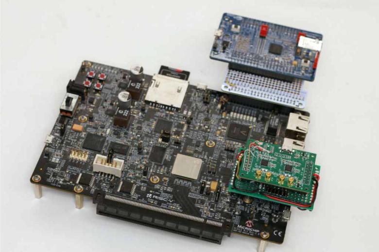
Image: ACSER

Image: ACSER

The University of New South Wales has developed an advanced GNSS receiver that can receive signals from GPS and Galileo satellites across multiple frequencies. The Australian Space Agency provided funding for the project via the International Space Investment initiative.

The receiver may play a key part in the future for Australian space missions.

Professor Andrew Dempster, director of the Australian Centre for Space Engineering Research (ACSER), led the development of the receiver and notes that it is an upgrade of Kea, a receiver made in Australia and New Zealand.

“The idea was to take that work (on Kea) and upgrade it for this multi-frequency, multi-system solution,” Professor Dempster said. “We needed to scale up the performance of many of the components on the boards – in particular, where the digital processors and hardware live.”

ACSER aims to have the receiver support upcoming satellite missions. The receiver can provide precise positioning, timing and velocity information. It enables satellites to produce higher quality images from space with better pointing.

Publicerad den Lämna en kommentar

Inertial Labs launches IMU-P

IMU-P.jpg

Image: Inertial Labs

Inertial Labs has launched its inertial measurement unit-P (IMU-P). It is an advanced MEMS sensors-based, compact, self-contained strapdown, industrial- and tactical-grade inertial measurement system and digital tilt sensor that measures linear accelerations, angular rates and pitch-and-roll with three-axis, high-grade MEMS accelerometers and three-axis, tactical-grade MEMS gyroscopes.

Angular rates and accelerations are determined with high accuracy for both motionless and dynamic applications.

Like Inertial Labs IMU-FI-200C, the IMU-P is fully calibra

ted, temperature compensated, and mathematically aligned to an orthogonal coordinate system. IMU-P demonstrates less than 1 deg/hr gyroscopes and 0.005 mg accelerometers bias inrun stability with low noise and high reliability.

The IMU-P models collect data from an external source of GNSS to output full spectrum inertial navigation system data consisting of positions, attitude, velocity and time.

The IMU-P is suitable for applications such as antenna and line of sight stabilization systems, GPS-aided INS, UAV & AUV/ROV navigation and control and more.