Publicerad den Lämna en kommentar

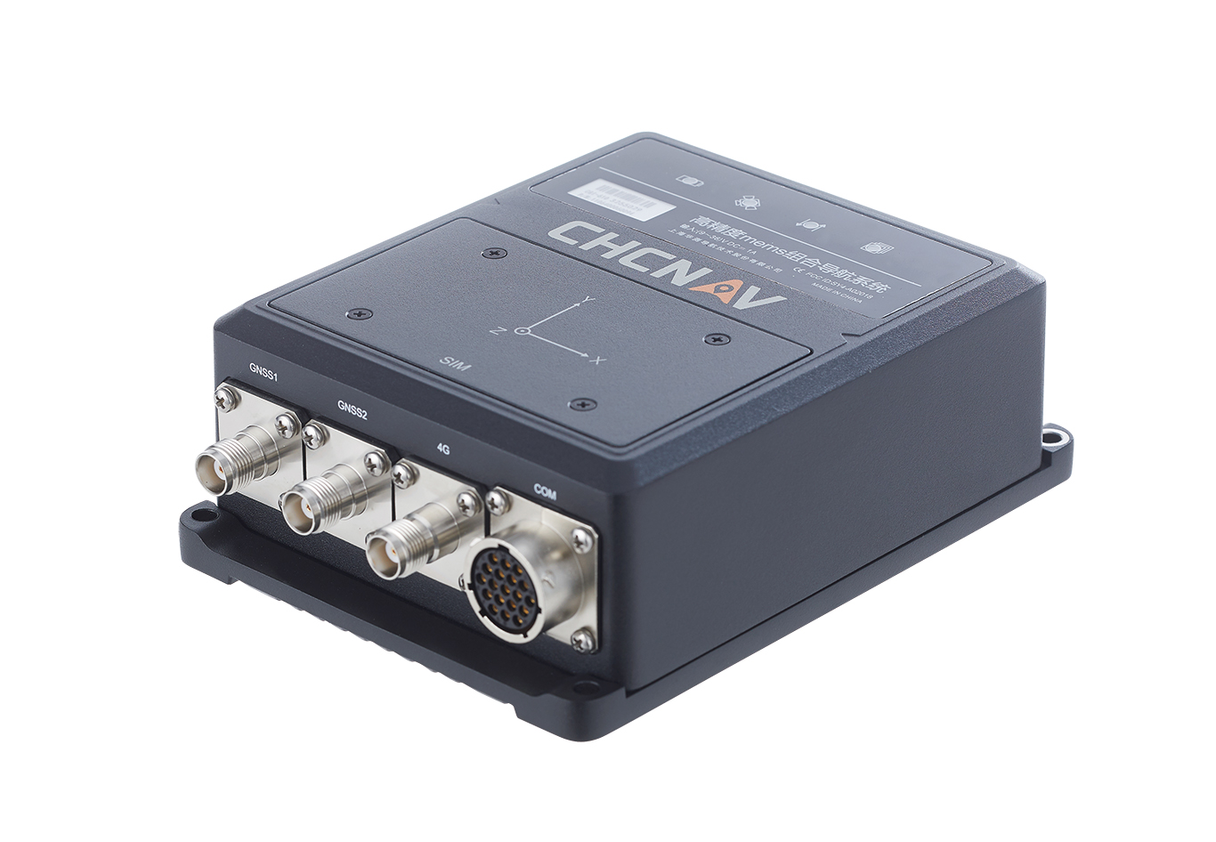
Hybrid GNSS+INS sensor: Navigates challenging environments

Image: CHC Navigation

Image: CHC Navigation

The CHCNAV CGI-610 GNSS/INS sensor is an advanced dual-antenna receiver designed for reliable and accurate navigation and positioning in challenging terrestrial, marine or airborne applications.

Designed to meet the needs of 3D positioning and autonomous vehicle guidance applications, it provides high performance in urban canyons and other harsh environments where GNSS signals are lost or degraded. Incorporating the latest GNSS technology and an industrial-grade inertial measurement unit, the sensor delivers accurate hybrid position, attitude and velocity data up to 100 Hz, driven by CHCNAV algorithms.

Its rugged and lightweight package ensures uninterrupted performance and meets high protection standards.

Publicerad den Lämna en kommentar

BAE Systems and Lockheed Martin tests UAS

Image: Air Force Staff Sgt. Rachel Simones/ Department of Defense.

Image: Air Force Staff Sgt. Rachel Simones/ Department of Defense.

BAE Systems and Lockheed Martin Skunk Works partnered to test the Skunk Works Stalker and Indago UAS on BAE Systems’ amphibious combat vehicle (ACV) command, control, communication and computers (C4)/UAS variant. The UAS will provide reconnaissance capabilities to support U.S. Marine Corps expeditionary warfare and battle management capabilities.

BAE Systems tested the Stalker and Indago UAS — in addition to other technology suppliers — as a part of contractor verification testing. With contractor verification testing complete, the USMC plans to conduct additional tests to evaluate whether the AVC C4/UAS is a solution for the Advanced Reconnaissance Vehicle program.

“By integrating Stalker and Indago on BAE Systems’ ACV platform, we are delivering greater mission flexibility in a small form factor that supports Marine Corps operations,” Jacob Johnson, Skunk Works UAS and attritable systems director, said.

The Skunk Works Stalker and Indago UAS provide a broad operating envelope and endurance, which enables diverse and demanding missions while maintaining a small operational footprint and crew requirement.

BAE Systems’ ACV C4/UAS vehicle is a mobile systems integration lab built to demonstrate the technology Marines need to conduct reconnaissance, surveillance and acquisition capabilities, including the ability to sense and communicate targets over the horizon using C4 systems.

Publicerad den Lämna en kommentar

OxTS product now available with additional features

OxTS Georeferencer 2.5

Image: OxTS

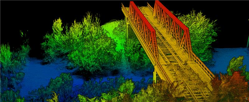
OxTS has released its Georeferencer 2.5 with the anyNAV feature and eight lidar sensors from RoboSense. Georeferencer 2.5 featuring anyNAV software is suitable for survey applications.

Users of Georeferencer 2.5 with anyNAV feature enabled can boresight payloads and georeference lidar data using the user’s navigation data. The anyNAV software enables lidar surveyors to create accurate pointclouds quickly.

Georeferencer 2.5 now takes navigation data from third-party inertial navigation systems, which enables users to use that data to georeference raw lidar data from multiple sensor families. The resulting data can then be viewed in many pointcloud viewer software packages.

Publicerad den Lämna en kommentar

Safran Electronics and Defense releases defense PNT system

NAVKITE on board a vessel. (Image: Safran Electronics and Defense)

NAVKITE on board a vessel. (Image: Safran Electronics and Defense)

Safran Electronics and Defense and Fuscolab, the innovation lab for the French Marine Corps, released a resilient position, navigation, and timing (PNT) system, NAVKITE. It provides navigation integrity and performance over long periods of time and under demanding circumstances on land and at sea.

NAVKITE meets operational requirements for the French Navy Commandos and will be integrated in Embarcation Commando a Usage Multiple Embarquable (ECUME) — a transportable, multirole, semi-rigid boat purpose-designed for commandos and other special forces.

NAVKITE’s capabilities depend on the coupling of Safran’s Geonyx M inertial navigation system with the VersaSync time/frequency server. Together, they handle the transmission of PNT data to ensure mission continuity.

The first sea trials of the system, conducted by Fuscolab and the Ponchardier commando unit, demonstrated NAVKITE’s performance under operational conditions. It was then successfully deployed in February in the joint services exercise Hemex, during phase two of Orion, a large-scale operation for resilient, innovative and interoperable armed forces focused on high-intensity conflicts.

Publicerad den Lämna en kommentar

Sikorsky partners with CMC Electronics for FMS

Image: CMC Electronics

Image: CMC Electronics

CMC Electronics has entered a multi-year contract with Sikorsky, a Lockheed Martin company, to supply its CMA-2082MC military flight management system (FMS) for several Sikorsky helicopter models, including the UH-60M, HH-60M, HH-60W, S-70i and the S-70M.

CMA-2082MC is a complete FMS with integrated radio management, which provides centralized control of navigation sensors, communication radios, mission avionics and more. It is also highly reliable while operating in harsh environments.

The helicopters complete with CMA-2082MC military FMS will be delivered to the U.S. Army and the U.S. Air Force, as well as several Black Hawk customers for use in a wide range of missions including search and rescue, troop transport, medical evacuation, disaster relief, aerial firefighting and border patrol.

Publicerad den Lämna en kommentar

Raytheon completes JPALS delivery to U.S. Nav

Image: U.S. Department of Defense / Raytheon Technologies

Image: U.S. Department of Defense / Raytheon Technologies

Raytheon Technologies has delivered all 23 contracted Joint Precision Approach and Landing Systems (JPALS) low-rate production units to the U.S. Navy to ship to Japan. Raytheon announced the contract with the Navy back in February to provide JPALS to the Japan Maritime Self-Defense Force (JMSDF), which will be deployed on the JMSDF JS Izumo carrier in 2024.

JPALS is a software-based GPS navigation and precision approach landing system that guides aircraft onto carriers and amphibious assault ships regardless of sea state or weather conditions, bolstering safety and operational capability.

JPALS is deployed on all U.S. Navy aircraft carriers and amphibious assault ships, as well as all F-35 aircraft. In addition, JPALS are deployed on platforms from two countries: the UK Royal Navy’s HMS Queen Elizabeth, and the ITS Cavour, an Italian aircraft carrier, to support their F-35 squadrons.

Raytheon has also developed an expeditionary variant of JPALS called eJPALS, which is a smaller, portable system that could be packaged in ruggedized cases, mounted on small vehicles, and deployed in austere, remote locations for precision landings. The system could establish up to 50 different landing points within a 20-nautical-mile radius.

Publicerad den Lämna en kommentar

Research Roundup: Space and lunar applications

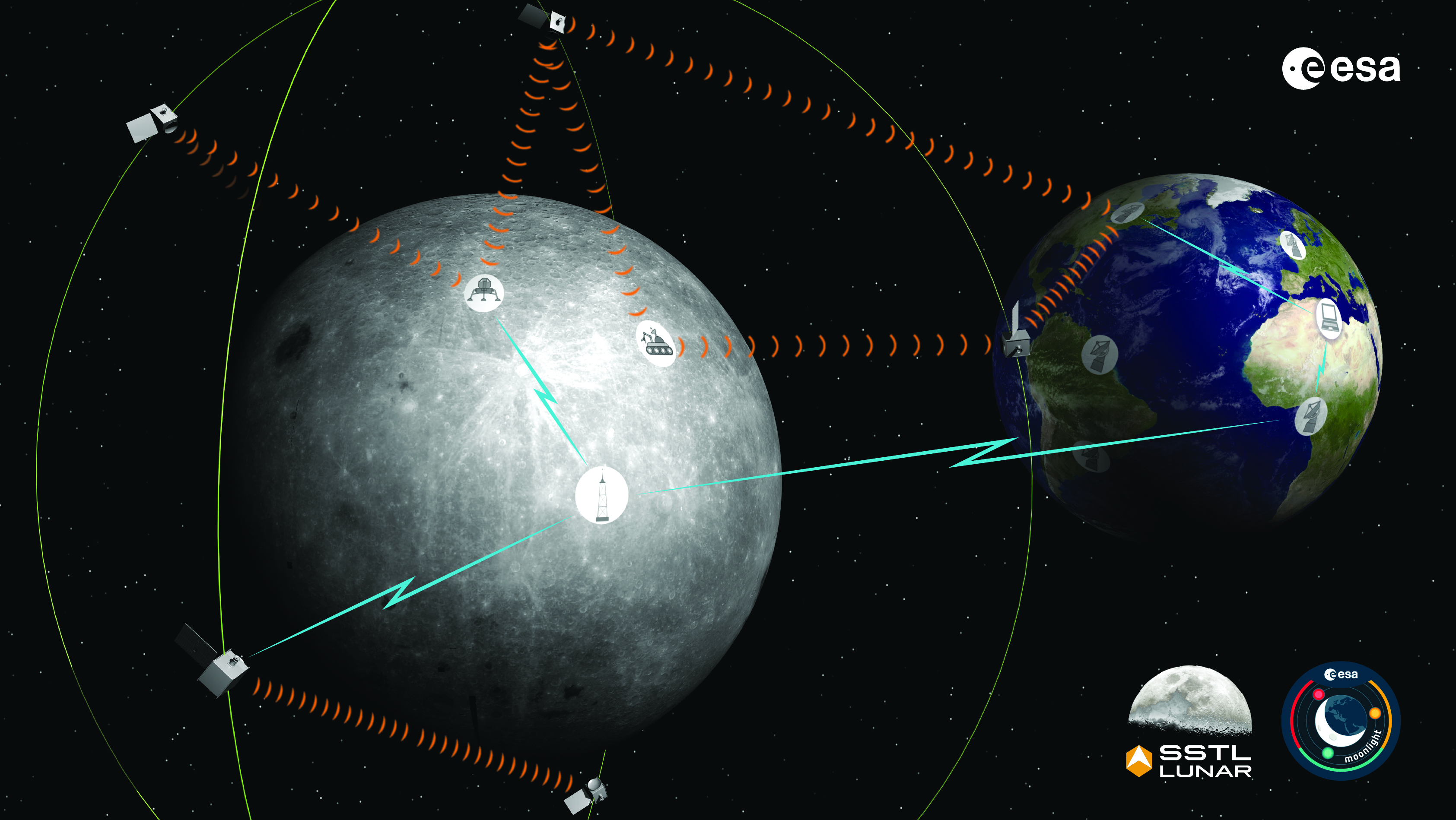
The Moonlight initiative will provide sustainable lunar data-relay services for communication and navigation around the Moon. (ESA Moonlight Study conceptual drawing.) (Image: SSTL/Airbus/ESA)

The Moonlight initiative will provide sustainable lunar data-relay services for communication and navigation around the Moon. (ESA Moonlight Study conceptual drawing.) (Image: SSTL/Airbus/ESA)

GNSS researchers presented hundreds of papers at the 2022 Institute of Navigation (ION) GNSS+ conference, which took place Sept. 19–23 in Denver, Colorado, and virtually. The following five papers focused on lunar and space applications. The papers are available now.

MTO Navigation Using Lunar Signals

The moon transfer orbit (MTO) is becoming increasingly important as several national space agencies are planning moon exploration soon, with projects such as NASA’s Artemis. In previous research, the GPS navigation accuracy on the MTO reached 200 m at the moon altitude by using GPS signals emitted from the far side of Earth. As accuracy on a low-Earth orbit (LEO) using GPS is a few meters, 200 m accuracy is not accurate enough to support lunar exploration. The deterioration of accuracy is due to the poor geometry of the GPS satellites that became visible from the MTO.

The authors want to achieve an accuracy of less than 100 m in MTO by using other navigation sources, including the lunar navigation satellite system (LNSS) to be deployed in the moon’s orbit. The LNSS signals will come from the far side of the moon, similar to the signals of GPS satellites coming from the opposite side of Earth. Its satellites will be pointed towards the moon to provide positioning, navigation and timing services on the moon surface, especially at the lunar South Pole region

The researchers have been conducting the simulation evaluation for the MTO navigation accuracy using signals coming from the moon and assume that these signals will be emitted from beacons on the moon surface or the LNSS.

Murata, Masaya; Kogure, Satoshi; “Moon Transfer Orbit Navigation Using Signals Coming from the Moon.”

Designing the Smallsat-Based LNCSS

There is growing interest in the use of a smallsat platform for the future lunar navigation and communication satellite system (LNCSS); however, many design considerations are not finalized for the smallsat-based LNCSS, such as choice of the satellite clock, satellite orbital parameters and the constellation size.
Using the Systems Tool Kit simulation software, the authors examined various LNCSS constellation case studies based in elliptical lunar frozen orbit and with a low-grade chip-scale atomic clock.

They evaluated case studies of navigation design considerations including position and timing accuracy, lunar user equivalent ranging error, and dilution of precision. As for case studies of communications design considerations, the authors examined daily data volume, availability and data rate. Finally, they examined smallsat factors including the cost, size, weight and power of the satellite payload.

The paper includes trade-off analysis in satisfying the preliminary design criteria outlined by international space agencies and commercial space companies.

Bhamidipati, Sriramya; Mina, Tara; Sanchez, Alana; Gao, Grace; “A Lunar Navigation and Communication Satellite System with Earth-GPS Time Transfer: Design and Performance Considerations.”

Developing an SDR for Space

A geostationary satellite (GEO) equipped with the satellite-based augmentation system (SBAS) function has a transmitter for GNSS correction signals at the L1 and L5 bands. This transmitter could interfere with the GNSS space service volume (SSV) receiver in the same satellite, so L1 and L5 signals cannot be used for the GEO SBAS satellite. However, the use of GPS L2C signals can be an alternative.

The authors of this paper present the development of a GPS L2C signal generator for the SSV in GEO simulation. They present the simulation process for GEO satellites and the structure of the GPS L2C signal generator.

In this study, a verification through the receiver test with a GNSS software-defined receiver is included to show the possibility of the designed signal simulator. The validation is performed by analyzing the programmable system device, the results of the acquisition, code/carrier tracking, and the C/N0 estimation.

Lee, Hak-beom; Choi, ByeongHyun; Song, Young-Jin; Won, Jong-Hoon; Kwon, Ki-Ho; “Development of GPS L2C Signal Generator for SSV in Geostationary Orbit Simulation.”

Differential Positioning on the Moon

This paper introduces a new concept of delivering the pseudorange correction calculated at a reference station on the lunar surface, as a part of the lunar navigation satellite system (LNSS) navigation message. The concept enables LNSS users to apply differential positioning using pseudorange correction without adding new hardware to their receivers.

The authors propose the differential positioning technique to reduce the signal-in-space range error of LNSS satellites and the coordinate transformation errors from Earth-centered fixed frame to lunar reference frame — the dominant errors in satellite positioning by LNSS.

The proposed reference station is equipped with instruments to externally estimate its own position relative to the lunar reference frame. The user on the lunar surface would then perform differential positioning using the station coordinate and pseudorange correction obtained at the reference station.
In this study, the simulation results using eight elliptical lunar frozen orbit satellites show that the real-mean-squared values for both horizontal and vertical positioning errors with differential correction are reduced to 1/10 of those without differential correction, even at 10 degrees latitude from the reference station at the lunar South Pole.

Akiyama, Kyohei; Murata, Masaya; Kogure, Satoshi; “Differential Positioning Performance on Lunar South Pole Region Using Lunar Navigation Satellite System.”

GEO Precise Orbit Determination

Using GPS in satellites in geostationary (GEO) orbits provides advantages by improving position, velocity and timing data, reducing operating costs and providing autonomous orbit control for station keeping. This paper presents the result of the onboard data evaluation and precise orbit determination of an optical data-relay satellite (ODRS) using GPS L1 C/A code and carrier-phase observations for 74 days.

As a result of precise orbit determination, the authors found that both code- and carrier-phase observations are affected by the ionospheric delay when signals pass through the plasmasphere located above the ionosphere.

Several methods were implemented during this research to reduce the effect of the plasmasphere, including setting a higher cut-off altitude, applying correction sequences generated from orbit determination residuals, and applying a new observation noise model depending on the GPS off-nadir angle. Results show that the correction sequences and the new noise model improve the internal orbit consistency. The authors also found that the orbit bias in radial direction due to negatively biased carrier-phase observations is mitigated from –51 cm to –17 cm by setting a higher cut-off altitude and applying correction sequences.

Matsumoto, Takehiro; Sakamoto, Takushi; Yoshikawa, Kazuhiro; Kasho, Sachiyo; Nakajima, Ayano; Nakamura, Shinichi; “GEO Precise Orbit Determination Using Onboard GPS Carrier Phase Observations of Optical Data Relay Satellite.”

Publicerad den Lämna en kommentar

Utah UAV company aids defense industry

Spencer Cox, the governor of Utah, toured Teal Drones headquarters in Salt Lake City, to learn about Teal’s operations, the company’s impact on the national aerospace and defense industries and opportunities and challenges facing Utah’s local defense industry. The visit was organized by the newly created Utah Aerospace and Defense Association (UADA).

“Teal is deepening its relationship with UADA to help accelerate the rebuilding of America’s defense industrial base, specifically for UAVs,” George Matus, Teal Drone founder and CEO said.

Teal is certified as “Blue UAS,” authorizing the company to provide equipment to the U.S. military. Teal is also one of three UAV manufacturers invited to participate in the U.S. Army’s Short Range Reconnaissance Tranche 2, designed to deliver a portable small uncrewed aerial system that can be used by army platoons for surveillance, reconnaissance duties and improving situational awareness.

UADA was established in 2022 to address challenges associated with innovation, entrepreneurship, workforce development and supply chains for companies in the aerospace and defense industries.

“For far too long, we have ceded the building of UAVs to China and other places,” the governor said. “We are bringing that back and Utah is at the center of that.”

Publicerad den Lämna en kommentar

SingularXYZ launches development kit

Image: SingularXYZ

Image: SingularXYZ

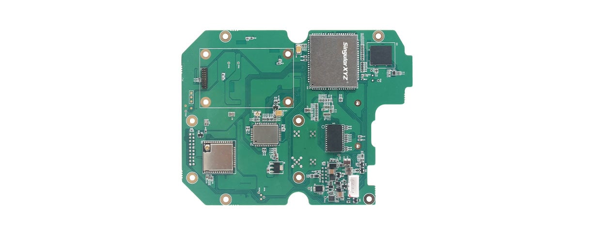
SingularXYZ, a manufacturer of GNSS technology, has launched its DK100 development kit. This multi-functional kit has selectable single-antenna and dual-antenna modules, full constellation tracking and centimeter-level positioning.

The DK100 development kit is a ready-to-use kit designed to simplify integration efforts and increase compatibility with a variety of applications. The kit reserves standard adapter board interfaces to connect different GNSS modules and radio modules for a variety of needs.

The development kit features a 4G module, Wi-Fi, Bluetooth, and Ethernet modules as well as status indicators on a single PCBA.

The DK100 development kit comes with its own web page for configuration. With Ethernet and Wi-Fi access, users can monitor device status and configure working mode and data transmission settings on the page.

The centimeter-level DK100 kit can be integrated in a range of horizontal and vertical applications, such as construction using CORS networks, precision agriculture, construction machinery, smart navigation, monitoring, robotics, unmanned systems and more.

The new DK100 development kits are available now.

Publicerad den Lämna en kommentar

TikTok hearing highlight: CEO says it does not collect location data

On March 23, Shou Zi Chew, CEO of the popular app TikTok, testified before Congress that TikTok does not collect precise location data from its users.

During the hearing, which lasted for more than five hours, Chew assured committee members that the app does not collect nor distribute location data. The terms of service for TikTok also do not mention collection of precise location data.

TikTok is under fire as a bipartisan Senate proposal is aimed at banning the social media app, arguing that it poses cybersecurity risks. The House Committee interrogated Chew regarding the app’s algorithmic feed, policies for young users and —given TikTok’s Chinese ownership — the amount of access the Chinese government has to user data.