Publicerad den Lämna en kommentar

XPONENTIAL 2023: First day recap

Attendees crowded the show floor during AUVSI XPONENTIAL day one.

Attendees crowded the show floor during the first day of AUVSI XPONENTIAL 2023.

AUVSI XPONENTIAL is underway in Denver, Colorado, at the Colorado Convention Center. After the first day of touring the XPO Hall of more than 600 exhibits and attending educational sessions lead by industry leaders and speakers, GPS World staff noticed a key theme: mitigating GNSS jamming and spoofing by advancing technology for UAVs.  

Educational Sessions

Photo:

Franck Boynton, Vice President of NavTachGPS, highlighted Tallysman ‘s HC871SXF during his “Real World GPS/GNSS Protection from Start to Finish,” presentation.

“Real World GPS/GNSS Protection from Start to Finish,” was presented by Franck Boynton, Vice President of NavTechGPS. He discussed why anti-jam equipment is needed and how to mitigate jamming. Boynton mentioned several anti-jam products, such as NovAtel’s OEM series product line, Septentrio’s AIM+, Tallysman’s HC871SXF and more.

Additionally, GPS World contributing writer, Dana Goward, received a mention for his article regarding the GPS jamming incident on Jan 21, 2022, at Denver International Airport, which can be found here. Boynton also suggested checking out the RNT Foundation, which is a nonprofit, public benefit corporation that helps protect critical infrastructure by promoting resilient navigation and timing, of which Goward is the president and director.

“The Importance of GNSS Security in UAV Applications,” featured a panel of speakers that included (from left to right) Captain Joe Burns, CEO of the Airo Group and member of the National Space-Based Positioning, Navigation and Timing Advisory Board, Jeff Horne, vice president of security at Skydio Abigail Smith, executive director of UAS security at the FAA, Gustavo Lopez, market access manager at Septentrio, and moderated by Michael Glutting, sales manager at Septentrio.

“The Importance of GNSS Security in UAV Applications,” featured a panel of speakers that included (from left to right) Captain Joe Burns, CEO of the Airo Group and member of the National Space-Based Positioning, Navigation and Timing Advisory Board, Jeff Horne, vice president of security at Skydio Abigail Smith, executive director of UAS security at the FAA, Gustavo Lopez, market access manager at Septentrio, and moderated by Michael Glutting, sales manager at Septentrio.

“The Importance of GNSS Security in UAV Applications,” featured a panel of speakers that included Abigail Smith, executive director of UAS security at the FAA, Captain Joe Burns, CEO of the Airo Group and member of the National Space-Based Positioning, Navigation and Timing Advisory Board, Gustavo Lopez, market access manager at Septentrio, Jeff Horne, vice president of security at Skydio, and moderated by Michael Glutting, sales manager at Septentrio. During the panel discussion, the speakers explained types of GPS interference, including jamming and spoofing, and the risk they pose to UAVs. The latest methods for strengthening both GNSS receivers and control units to design secure and robust UAVs was also discussed.

Day-of highlights

Maddie Saines, managing editor, and Jesse Khalil, digital media specialist, had the opportunity to stop by several booths in the XPO Hall on the first day of XPONENTIAL. A few highlights from the day included speaking with Ahmet Salih Erdem, deputy general manager at Tualcom, getting an in-depth look at SBG System’s Qunata Mirco and Ekinox Micro with Yoann Plenet, head of product management, and getting a first-hand look into the newest products from Tallysman Wireless — such as SSL889XF — from Ken MacLeod, product manager for Tallysman.

SBG System's Qunata Mirco and Ekinox Micro.

SBG System’s Qunata Mirco and Ekinox Micro.

Ken MacLeod, product manager for Tallysman, showcasing the SSL889XF.

Ken MacLeod, product manager for Tallysman, showcasing the SSL889XF.

Tualcom's booth at XPONENTIAL 2023 showcased new products such as ANTY, its GPS Anti-Jammer.

Tualcom’s booth at XPONENTIAL 2023 showcased new products such as ANTY, its GPS anti-jamming device.

Publicerad den Lämna en kommentar

Percepto receives FAA waiver to scale shielded BVLOS commercial UAS operations

Percepto has received a waiver from the Federal Aviation Administration (FAA) that allows it to operate unmanned aerial systems (UAS) beyond visual line of sight (BVLOS) in shielded airspace — without humans onsite, and without ground-based or airborne detect and avoid (DAA) systems — for inspection and monitoring operations at critical and non-critical infrastructure sites nationwide.

Under the waiver, low risk “shielded” BVLOS operations are authorized 200 ft above and around assets located on critical infrastructure sites. At non-critical infrastructure sites, shielded BVLOS operations are permitted 50 ft above and around the height of the tallest obstruction located within a half-mile radius of the site.

The operations authorized under this approval build upon recommendations made by the UAS BVLOS Aviation Rulemaking Committee chartered by the FAA. The ARC recognized that shielded airspace near structures and other obstacles where crewed aircraft do not typically operate could be leveraged as a safety mitigation to support safe, scalable, and economically viable UAS BVLOS operations.

The use of Percepto’s UAS to perform critical infrastructure inspections aims to improve worker safety and efficiency of operations by enabling inspections remotely from anywhere in the United States.

Percepto is at XPONENTIAL May 9-11, at booth 3409.

Publicerad den Lämna en kommentar

Qualcomm and FlightOps collaborate on UAV tech for first responders

Image: Qualcomm

Image: Qualcomm

FlightOps is collaborating with Qualcomm Technologies to develop UAV automation technology designed specifically for first responders. FlightOps has integrated its advanced UAV automation technology onto the Qualcomm Robotics RB5 platform — which has 5G connectivity, on-device artificial intelligence, and heterogeneous computing capabilities.

The integration of FlightOps’ technology onto the Qualcomm Robotics RB5 will enable the platform to automate critical tasks such as flight planning, monitoring, and data collection, enabling first responders to focus on the mission at hand.

The technology is being showcased during XPONENTIAL May 9-11. FlightOps is at booth 4041.

The live remote flights, operated from Denver and flown in San Diego, will demonstrate the capabilities of the integrated product and how it can be used to improve response times as well as enhance situational awareness during emergencies.

Publicerad den Lämna en kommentar

Harxon releases helix antenna series

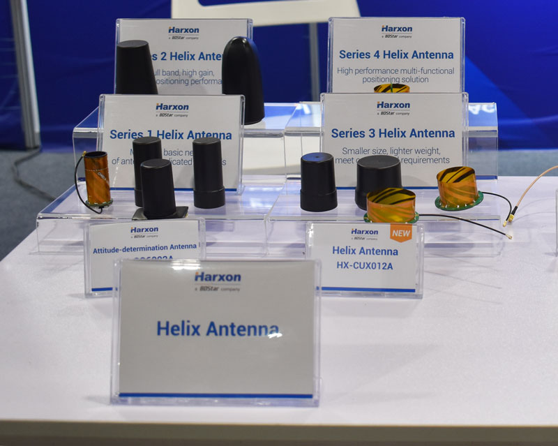
The HX-CUX012A, HX-CUX005A, HX-CH7609A and HX-CHX600A antennas at Harxon's XPONENTIAL 2023 booth.

The HX-CUX012A, HX-CUX005A, HX-CH7609A and HX-CHX600A antennas at Harxon’s XPONENTIAL 2023 booth.

Harxon has added to its helix antenna family with a series of four devices that are suitable for unmanned system applications.

HX-CUX012A is designed with extremely low profile, making it suitable for integration into UAVs, surveying and monitoring devices. It reduces the overall weight of applications, enables multipath mitigation and more.

HX-CUX005A is a solution for integrated helix antenna applications. It is designed with the integration of a GNSS antenna and Bluetooth/WiFi antenna, enabling communication and navigation without mutual interference.

HX-CH7609A is a low profile and small size housed helix antenna. It has comprehensive GNSS support including GPS, GLONASS, Galileo, BeiDou, as well as L-band correction services. HX-CH7609A features centimeter phase center repeatability and high gain at a low elevation. With signal filtering and multipath rejection, it provides reliable and stable GNSS signals.  

HX-CHX600A is a high-performance helix antenna that receives GPS, Galileo, BeiDou, GLONASS, as well as L-band signals. With 4.2 dBi high gain, it provides suitable tracking performance at a low elevation angle. Its low noise figure design reduces transmission interference and improves signal quality. 

Publicerad den Lämna en kommentar

Start your engines: How F1 drivers use GPS

Credit: vvectors/iStock/Getty Images Plus/Getty Images

Credit: vvectors/iStock/Getty Images Plus/Getty Images

GPS plays a quiet, but integral role in Formula 1 (F1) racing. In a sport where split-second reactions are vital, GPS helps drivers and their teams to improve race to race and navigate tracks safely.

GPS is used to determine the speed of the car, which is beneficial for such things as straight line aerodynamic testing. It also provides data as to how fast F1 cars accelerate, enabling drivers and their teams to predict how much power their competitors are producing on the track.

The streaming of location data can be converted to telemetry, such as what track maps viewers see on F1 broadcasts, that can determine which driver in a head-to-head scenario was faster on each sector of the track. This data is then used to work out strengths and weaknesses of cars relative to each other.

In addition, GPS plays a large role in creating a safe racing space.

If a driver is slowing down to recharge a battery, make space for a hot lap, or cool down tires between runs, and another car is entering the track at full racing speed, this creates safety concerns. GPS receivers on the cars and radio links to transmit their positions are used to show where cars are on the track at any moment. Teams use this information to manage traffic during sessions such as qualifying races to improve overall track safety.

The impact of losing live location data was seen at the 2023 Australian Grand Prix FP1 in late March. At the opening practice session, a red flag was flown due to loss of location data triggered by a glitch in the distribution of live tire information. This caused several near-misses on the track because drivers no longer received traffic advisory calls from their team, reported AutoSport.

For more on using GPS in F1, check out the video below by WTF1.

Publicerad den Lämna en kommentar

Honeywell AAM reference guide on vehicle certification

Image: Honeywell

Image: Honeywell

Honeywell has developed the advanced air mobility (AAM) industry’s first certification reference guide across key vehicle segments. Business and government leaders, engineers, media and any user with an interest in the future of flight can use the Honeywell State of UAS and UAM Certification Guide to help navigate and communicate the complexities of vehicle certification and operational approval across multiple vehicle segments.

“We understand the challenges that professionals working in the advanced air mobility industry face as they look to navigate, track and ultimately comply with myriad developing regulations,” Jia Xu, chief technology officer, UAM and UAS, Honeywell Aerospace, said. “Because Honeywell provides certifiable, mission-critical systems that make AAM vehicles fly, it’s essential that we understand the certification landscape across all AAM segments. We initially developed this certification summary table as a quick reference for our own team; however, we quickly realized that the information here can benefit the wider industry. We intend to update this document regularly to help AAM companies keep pace with regulatory development.”

Industry professionals can access the living document at the following link. The certification reference guide will summarize evolving Federal Aviation Administration and European Union Aviation Safety Agency rules across multiple AAM segments. It will also link to source documents that AAM professionals can reference to better understand detailed certification requirements.

Publicerad den Lämna en kommentar

Leica Geosystems advances autonomous mobile mapping

Image: Leica Geosystems

Image: Leica Geosystems

Leica Geosystems, part of Hexagon, has released an addition to its Leica Pegasus TRK portfolio of mobile mapping solutions, the Leica Pegasus TRK100. The mobile mapping system is a geospatial solution built for large-scale infrastructure measurement and digital twin creation.

The Pegasus TRK100 is small and light, making it easy to mount on any vehicle. The mobile mapping system features the same modular hardware approach that enables users to add more cameras to expand the range of use cases.

Image: Leica Geosystems

Image: Leica Geosystems

With its advanced mapping capabilities, the Pegasus TRK100 enables GIS professionals to visualize and understand the location of assets to help make the right decisions, improve asset management, and support infrastructure building and maintenance. The Pegasus TRK100 combines artificial intelligence and a learning algorithm to enhance and optimize the clarity of points in post-processing for improved accuracy.

The versatility of the Pegasus TRK100 suits a variety of applications in diverse industries, including telecommunications, utilities and road maintenance.

“The Leica Pegasus TRK100 advances autonomy and artificial intelligence in mobile mapping, removing manual process steps and providing actionable insights for informed decision,” Christian Schäfer, business director mobile mapping at Leica Geosystems, said. “It empowers GIS professionals to create the maps they need, collect the information they require, and visualize the data in a way that immediately aids understanding.”

Publicerad den Lämna en kommentar

Tallysman releases HC871SXF GNSS helical antenna

Credit: Tallysman Wireless

Credit: Tallysman Wireless

Tallysman Wireless has released its dual-band low-profile helical GNSS antenna, the HC871SXF. It is designed for precise positioning, covering the GPS/QZSS-L1/L2, GLONASS-G1/G2, Galileo-E1, and BeiDou-B1 frequency bands, including the satellite-based augmentation system (SBAS) available in the region of operation — WAAS (North America), EGNOS (Europe), MSAS (Japan), or GAGAN(India).

The HC871SXF has a precision-tuned, high-accuracy helical element that provides a suitable axial ratio and operates without a ground plane. These features make the HC871SXF suitable for lightweight, UAV navigation and a variety of precision applications.

The HC871SXF low-profile helical antenna is approximately 10 mm shorter than the HC871 and provides the same performance. The antenna base has a male SMA connector. To facilitate installation, the base also has two threaded inserts and an O-ring to waterproof the SMA connection.

The HC871SXF antenna also supports Tallysman’s eXtended Filtering (XF) technology.

Publicerad den Lämna en kommentar

OxTS releases INS for automation

Credit: OxTS

Credit: OxTS

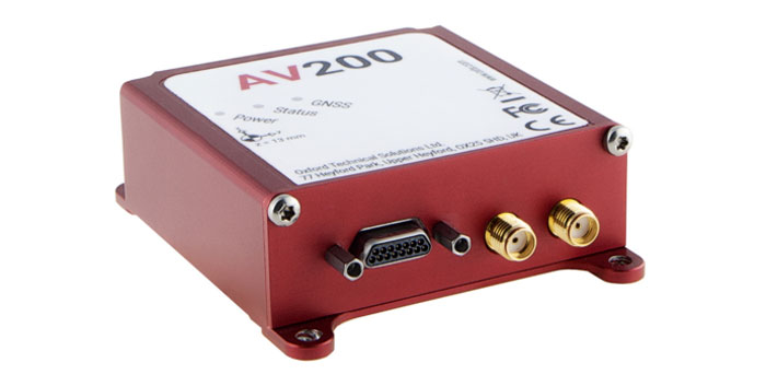
OxTS has released the AV200, its inertial navigation system (INS) built for automation applications.

The AV200 is designed to reliably give precise location data. It includes quad-constellation, dual-antenna, real-time kinematic (RTK) GNSS, to provide users with position data as well as its temperature-calibrated, multi-core inertial measurement unit. These technologies give the AV200 position accuracy within 0.05 m, heading accuracy of 0.2°, and velocity accuracy of 0.2 km/h.

The AV200 is built using the same technology that is commonly used for NCAP test validation, which has become the preferred technology for OEMs globally to test vehicles in both test-track and real-world scenarios.

The AV200 has also been built specifically to address the realities of the autonomy market.

OxTS is at XPONENTIAL May 9-11, at booth 2148.

Publicerad den Lämna en kommentar

Singular XYZ launches GNSS receiver with network RTK rover

Singular XYZ has released the Sfaira One GNSS receiver. The portable size, centimeter-accurate receiver provides users with an entry-level network real time kinematic (RTK) rover.

Sfaira One is equipped with a GNSS module with 1,408 channels for GPS, BDS, GLONASS, Galileo and QZSS tracking — providing centimeter positioning in harsh environments. It also features advanced RTK and an anti-interference algorithm.

The GNSS receiver connects via Bluetooth and can be configured to conduct surveying tasks on a smartphone. Additionally, Sfaira One supports SingularPad and SingularSurv software and is also compatible with mainstream field survey or GIS software.

Sfaira One is IP65 dustproof and waterproof, which makes the receiver suitable for all weather conditions. It has a 4,800 mAh battery life with 16 hours working time and type-C interface that can be charged on-the-go with power bank.

The Sfaira One GNSS receivers are online at SingularXYZ’s website and are available now.