Publicerad den Lämna en kommentar

Lockheed delivers GPS III ground system upgrade, SV03 ready for launch

Technicians successfully integrated the U.S. Air Force’s third GPS III space vehicle (GPS III SV03) on August 14, 2017. (Photo: Lockheed Martin)

Technicians successfully integrated the U.S. Air Force’s third GPS III space vehicle (GPS III SV03) on August 14, 2017. (Photo: Lockheed Martin)

On May 22, Lockheed Martin delivered the GPS III Contingency Operations (COps) software upgrade to the U.S. Air Force’s current GPS ground control system.

The upgrade will enable the Air Force to start commanding the new, next-generation GPS III satellites now coming off the production line and beginning to launch.

And the new GPS III satellites are coming. The first GPS III satellite launched in December 2018; the second GPS III shipped to Cape Canaveral in March for a July launch; and on May 17, the Air Force declared the third new GPS III “Available for Launch” next.

Ground System. The challenge was modernizing the current ground system — formally known as the GPS Architecture Evolution Plan Operational Control System (AEP OCS) — to fly the legacy constellation, as well as the new, modern GPS III satellites, until the next generation Operational Control System (OCX) Block 1, still in development, is delivered.

To address this, in 2016, the Air Force contracted Lockheed Martin to develop the GPS III COps program. Currently, the AEP OCS controls 31 GPS IIA, IIR, IIR-M and IIF satellites launched between 1993-2016. With the AEP OCS’ new GPS III COps upgrade, the Air Force will be able to command and control both the legacy satellites, as well the more powerful GPS III satellites.

Lockheed Martin shipped the U.S. Air Force’s first GPS III to Cape Canaveral, Florida ahead of its expected July launch. (Photo: Lockheed Martin}

Lockheed Martin shipped the U.S. Air Force’s first GPS III to Cape Canaveral, Florida ahead of its expected July launch. (Photo: Lockheed Martin)

“Positioning, Navigation and Timing is a critical mission for our nation and COps will allow the Air Force to gain early access to its new GPS III satellites,” said Johnathon Caldwell, Lockheed Martin’s vice president for Navigation Systems. “We just finished Final Qualification Testing and delivery on COps, and it will be integrated and installed on the AEP OCS over the summer. We look forward to the Air Force ‘flying’ a GPS constellation on the COps OCS which includes the new GPS III satellites, later this year.”

Meanwhile, the first GPS III space vehicle (GPS III SV01), launched in December 2018, is finishing up pre-operational on-orbit check-out. It continues to be controlled by OCX Block 0 software installed at Lockheed Martin’s GPS III Launch and Checkout Center at the company’s Denver facility. GPS III SV01 is expected to be “handed over” to the COps OCS later this year after the legacy constellation is moved over to the updated AEP OCS.

Lockheed Martin has sustained the AEP OCS since 2013. In November 2018, the company completed the AEP 7.5 upgrade — the largest architectural change in the systems history — replacing significant code, hardware and software to improve the system’s cybersecurity capabilities and positioning the Air Force to better operate in contested, degraded and operationally limited environments.

In December 2018, the Air Force awarded Lockheed Martin the GPS Control Segment Sustainment II (GCS II) contract to continue to further modernize and sustain the AEP OCS through 2025. In 2020, the AEP OCS is expected to receive the M-Code Early Use (MCEU) upgrade, which will allow control of M-code, an advanced, new signal designed to improve anti-jamming and anti-spoofing, as well as to increase secure access to military GPS signals for U.S. and allied armed forces.

Lockheed Martin is under contract to develop and build up to 32 GPS III/IIIF satellites. GPS III will deliver three times better accuracy and provide up to eight times improved anti-jamming capabilities. GPS III’s new L1C civil signal will make it the first GPS satellite to be interoperable with other international global navigation satellite systems. Additional “IIIF” capabilities, beginning at the 11th satellite, will include a fully digital navigation payload, Regional Military Protection, an accuracy-enhancing laser retroreflector array, and a Search & Rescue payload.

Publicerad den Lämna en kommentar

ADS-B problem with GPS stems from faulty receiver

Image: FAA

Image: FAA

ADS-B transponder problems on some aircraft stem from a bad update to a large class of aviation receivers, according to a blog on the Resilient Navigation and Timing Foundation website. The Air Traffic Control System Command Center issued a blanket waiver on June 9 for all flights having GPS/ADS-B issues with their transponders.

According to various sources, the disruption briefly grounded entire fleets of regional jets. The resulting delays and cancellations rippled through the system.

On June 9, the FAA published a map purporting to show an area of GPS signal degradation in the United States. However,  the disruption appears to affect only certain Collins Aerospace (formerly Rockwell Collins) GPS receivers, according to AIN Online.

Collins Aerospace confirmed to AIN, “We identified a technical issue with our recently released GPS product(s) impacting availability, and have since determined the root cause and the resolution. We are engaging with our customers to ensure continued safe operational capability.”

The affected GPS receivers are GPS-4000S part number 822-2189-100 and GLU-2100 part number 822-2532-100.  It appears that all aircraft worldwide these receives are not able to locate satellite position signals.

“The absence of reports of problems from other modes of transportation and other industries certainly seems to justify refocusing from GPS signals to receivers as the root cause….” said the RNTF blog. “This is a good reminder for all that great signals in space are just one part of a ‘gold standard’ system. We also need unobstructed spectrum, great receiving equipment, and more than one source of great signals.”

Publicerad den Lämna en kommentar

Mercury-ion atomic clock holds promise for greater GPS accuracy

The National Aeronautic and Space Administration (NASA) is readying for an ultra-precise atomic clock that could not only transform the navigation of deep space missions, it could also improve the accuracy of GPS timing and thus GPS positioning. It is expected to launch in June.

DSAC graphic: NASA:

Drawing of the DSAC mercury-ion trap showing the traps and the titanium vacuum tube that confine the ions. The quadrupole trap is where the hyper-fine transition is optically measured and the multipole trap is where the ions are “interrogated” by a microwave signal via a waveguide from the quartz oscillator. (Image: NASA.)

The Deep Space Atomic Clock (DSAC) is a very small (the size of a toaster) mercury-ion atomic clock that is as stable as a highly precise ground atomic clock, yet small enough to fly aboard a spacecraft, and rugged enough to operate in deep space. Current ground-based atomic clocks that locate and navigate deep space missions are too massive to fly in space themselves.

Thus, tracking data from the far-flung spacecraft must be collected and processed on Earth, meaning a two-way tracking link. DSAC will enable NASA to improve tracking data precision by an order of magnitude for its deep space missions out to Jupiter, Saturn — and beyond.

It could also be used to improve the accuracy of GPS. DSAC is more stable and accurate than the atomic clocks currently aboard GPS satellites. As system modernization proceeds, use of a DSAC aboard future satellites holds out many promises. DSAC technology uses the property of mercury ions’ hyperfine transition frequency at 40.50 GHz to steer the frequency output of a quartz oscillator to a near-constant value.

The clock confines the mercury ions with electric fields in a trap and protects them by applying magnetic fields and shielding. It is anticipated that DSAC would produce only 1 microsecond of error over 10 years.

For further details on NASA’s Deep Space Atomic Clock project and detailed callouts on the diagram above, look here.

Publicerad den Lämna en kommentar

3D location platforms aids hotels, public safety indoors

Orion Labs has released Advanced Location Services, a high-accuracy, carrier-independent 3D location platform delivered via Polaris Wireless.

The service provides enterprises and public safety agencies with pinpoint location, indoors and in high-rise buildings, with floor-level and room-level accuracy, a difficult challenge in such GPS-denied environments.

Orion indoor location example (Screengrab: Orion)

Orion indoor location example (Screenshot: Orion Labs)

The system enables customers to locate team members on the vertical axis accurate to three meters’ distance, to keep teams better-informed and better-connected, enhance team performance and improve worker safety. It works via Orion Sync, a standalone smart walkie-talkie, or as device as a service, in a smartphone form factor.

“For our hospitality and retail customers, this offers the opportunity to greatly improve guest services and the experience they deliver. For public safety and healthcare customers, the integration has the potential to save lives,” said Jesse Robbins, founder and CEO.

According to co-founder and CTO Greg Albrecht, “With 3D location tracking, hospitality teams can easily pinpoint where their guest service workers are located and identify the right team member for faster guest response for tasks like bringing up clean towels to a guest, fixing a TV or lightbulb in a guestroom, or clearing trays and carts,” he said.

The system also protects lone workers. “When lone workers call for help, security teams can rapidly dispatch assistance without the lone worker needing to explain their location,” Albrecht said. “This is the same kind of technology that first responders are now adopting to accurately and rapidly locate 911 callers facing life-threatening situations.”

Hotel workers suffer work-related incidents, encompassing physical injuries, medical emergencies, theft and sexual harassment, nearly 50 percent more than is the average across all other industries. Large metropolitan hotels can approximate small cities, with as many as 5,000 rooms, 12,000 guests, and 8,000 employees. Even a moderate-sized hotel can have hundreds of employees scattered across many floors, some remote from central operations. Locating employees quickly is key to preventing or minimizing incidents.

Need maps. A fundamental challenge in developing 3D location awareness indoors is the need for accurate, detailed 3D renderings of the physical buildings themselves.

“For most buildings, this has never been done before and is often an arduous task to accomplish,” Albrecht added. “However, there is a mapping process to allow for precise data points to be leveraged within the Orion platform. It’s a very simple task that can be completed even by the hotel staff at the time of setup. After that, it’s extremely simple to set up teams within the Orion System with a 3D view of their property that they can use.”

The latest integration is undergoing tests at locations in Las Vegas and San Francisco, with more than 50 locations actively using the set-up.

In March, Polaris Wireless, a provider of software-based 3D location solutions to wireless operators, law enforcement and government agencies, and location-based application companies, announced the commercial availability of its high-accuracy carrier-independent 3D location platform for application developers.

In early 2018, Polaris Wireless participated in the CTIA’s Test Bed LLC Stage Z independent vertical location testing in San Francisco, Atlanta and Chicago, achieving floor-level accuracy.

Publicerad den Lämna en kommentar

Anti-jam, anti-spoof readied for European market

New initiatives from the Navigation Innovation and Support Programme (NAVISP), a program of the European Space Agency (ESA), have targeted counter-jamming and counter-spoofing efforts, as Europe’s Galileo program gains progressive foothold in the marketplace, particularly in safety-critical systems such as driverless cars.

“We are looking for new and disruptive ideas in navigation and that is why we created NAVISP,” said ESA Director General Jan Wörner.

GIDAS is a scalable and flexible real-time GNSS Interference Detection and Analysis System. (Image: TeleConsult Austria)

GIDAS is a scalable and flexible real-time GNSS Interference Detection and Analysis System. (Image: TeleConsult Austria)

TeleConsult Austria is working with JH Joanneum University of Applied Sciences on the GNSS Interference Detection and Analysis System (GIDAS), to automatically detect, classify and pinpoint all intentional interference sources within a given area by monitoring all civil GNSS signals in real time.The aim is to build a multi-frequency scalable system. GIDAS plans to begin commercialization at the end of 2019.

France Developpement Conseil has developed a hardened satnav module called DRACONAV, combining hardware and software to combat jamming and spoofing. Targeting intelligent transport applications, it seeks to identify cyber attacks and continue to provide authenticated positioning information as they occur.

DRACONAV would deliver a level of confidence to let users know if they can continue relying on the data the module delivers, and yield an estimate of the receiver’s true position as the attack continues. A prototype design has undergone more than 3,000 kilometers of field tests and is moving to industrialization.

Intecs Solutions of Italy has created G-Passion, using a software-defined radi

o to analyze a few tens or hundreds of milliseconds of Galileo signals at a time, to tell the user whether or not the signal is authentic or spoofed.
In Romania, InSpace Engineering’ MARGOT assesses the multipath and interference impact on PNT information in maritime environments.

The Norwegian company SINTEF is developing its Advanced Radio Frequency Interference Detection, Alerting and Analysis System (ARFIDAAS) project, offering as wide a spectral coverage as possible — including all current GPS, Galileo and GLONASS signals — to identify disruptions due to intentional or unintentional interference.

UK company Helix Technologies has developed compact helical antennas, built around a dielectric ceramic core, primarily for driverless cars. The multi-frequency design aims to reduce susceptibility to interference as well as multipath. Testing will soon get underway in several European cities.

Publicerad den Lämna en kommentar

US Army to equip light armored vehicles with new GPS anti-jam units

The U.S. Army will send prototype anti-jamming systems to its 2nd Cavalry Regiment, stationed in Europe, in September to aid forces under GPS jamming or spoofing conditions. The first generation of Mounted Assured PNT Systems (MAPS) and anti-jam antennas are nearly ready for integration aboard armored Stryker vehicles, and the Army is already evaluating proposals for an upgraded version incorporating an inertial navigation system (INS) for further resilience.

The shipment comes in response to widespread Russian jamming of GPS signals from the sub-Arctic to the Middle East, and in tacit, likely tardy acknowledgment of Russian superiority in electronic warfare.

An Interim Armored Vehicle "Stryker" and AH-64 Apache helicopters with Battle Group Poland move to secure an area during a lethality demonstration as part of Saber Strike 18 in June 2018. (Photo: U.S. Army/Spc. Hubert D. Delany III, 22nd Mobile Public Affairs Detachment)

An Interim Armored Vehicle “Stryker” and AH-64 Apache helicopters with Battle Group Poland move to secure an area during a lethality demonstration as part of Saber Strike 18 in June 2018. (Photo: U.S. Army/Spc. Hubert D. Delany III, 22nd Mobile Public Affairs Detachment)

Col. Nickolas Kioutas, Army project manager for Positioning, Navigation, and Timing (PNT) announced the move at the annual C4ISRnet conference in Arlington, Virginia. C4ISR stands for Command, Control, Communications, Computer, Intelligence, Surveillance, and Reconnaissance, or more broadly, electronic and other systems, procedures and techniques used to collect and disseminate information.

Three vendors are providing prototypes for the IMU-equipped second-generation MAPS, or MAPS-2, with testing to begin in September. A MAPS-3 capability, drawing on lessons learned in 1 and 2, may get underway soon. GPS Source, now a subsidiary of General Dynamics Mission Systems, made MAPS-1 and is now competing for MAPS-2.

The initiative reflects a new approach by the Army of “doing much smaller, iterative programs,” according to Col Kioutas. Traditionally, U.S. armed forces have taken years (and sometimes more years) to develop large, complex weaponry and supporting systems, and then even longer to deploy them. By the time they arrive in the operational theater, they are obsolete.

Rapid deployment of smaller, quickly designed and manufactured batches creates the opportunity for rapid feedback on what works and what doesn’t, with equally rapid return to the design board and re-manufacture. In other words, “shoot, aim, ready.”

Kioutas and crew are also flouting another U.S. military tenet, that in which previously “[we] asked for exactly what we wanted and industry built exactly to that. We don’t know exactly what we want. Tell us how we should do this the best, and then we’ll test that.” The PNT program has left requirements broad and open to change, knowing how quickly technology develops — and is shown to be vulnerable.

The Stryker is an eight-wheeled armored fighting vehicle, basically a lightly armored tank or heavily-armored troop carrier that is more road-friendly, that is, faster, than a tank.  It has several variants of armament, armor and troop-carrying capacity. It saw extensive use in the Iraq counter-insurgency campaign.

Publicerad den Lämna en kommentar

Two little eyes that can see and navigate

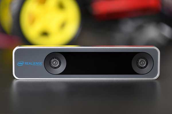
The RealSense camera uses two fisheye lenses and an IMU to construct location awareness. (Photo: Intel)

The RealSense camera uses two fisheye lenses and an IMU to construct location awareness. (Photo: Intel)

The Intel RealSense Depth Camera D435i, designed for positioning and maneuvering mobile robots and other portable systems, includes an inertial measurement unit (IMU) that enables developers to create solutions with advanced depth-sensing and tracking capabilities. Intel introduced the camera in 2018 and an advanced version early this year.

As robots, drones and other autonomous mobile devices must —eventually — interact independently and intelligently with their environments, they must track their locations as they move, navigating unfamiliar spaces while discovering, monitoring and avoiding still and moving obstacles in real time.

Block diagram of camera components. (Image: Intel)

Block diagram of camera components. (Image: Intel)

Moving toward that goal, the D435i includes two fisheye lens sensors, an IMU and an Intel Movidius Myriad 2 video processing unit (VPU), a system-on-chip component for image processing and computer vision at very high performance per watt.

Vision-based simultaneous localization and mapping (V‑SLAM) algorithms run directly on the VPU with very low latency. The T265 has demonstrated less than 1% closed-loop drift under intended use conditions. It also offers sub 6 ms latency between movement and reflection of movement in the pose.

The RealSense device measures 1 x 0.5 x 4 inches (108 mm x 24.5 mm x 12.5 mm), weighs around two ounces (55 g), and draws 1.5 watts to operate the entire system, including the cameras, IMU and VPU. Its spatial sensing and tracking capabilities are based on technology developed by RealityCap, acquired by Intel in 2015.

The camera performs inside-out tracking: it does not depend on external sensors to understand its environment. Tracking is based on information gathered from the two fisheye cameras, each with a 163-degree range of view (±5 degrees) and capturing images at 30 frames per second. The wide field of view from each sensor keeps points of reference visible to the system for a relatively long time, even if moving quickly.

Visual-Inertial Odometry. A key strength of visual-inertial odometry is that the sensors complement each other. The images from the camera are supplemented by data from the onboard IMU, which includes a gyroscope and accelerometer. The aggregated data from these sensors is fed into the SLAM algorithms.

The algorithm identifies sets of salient features in the environment, such as a corner of a room or object that can be recognized over time to infer the device’s changing position relative to those points.

The visual information prevents long-term drift from the inertial that degrades position accuracy. The IMU operates at a higher frequency than the cameras, allowing for quicker response and recognition by the algorithm to changes in the device’s position. A map of visual features and their positions is built up over time. In re-localization, the camera uses the features it has seen before to recognize when it has returned to a familiar place. The camera can locate its point of origin with an error margin of less than one percent.

Drone testing demonstrated that, in both cases, the tracking and position data generated by the peripheral was closely correlated with what was provided by GPS. This supports the viability of using it for navigation in areas where GPS is not available, such as under a bridge or inside an industrial structure.

Publicerad den Lämna en kommentar

DOT gets cracking on a new PNT concept

Congress mandated movement in December 2017.

U.S. National PNT Architecture from a 2007 Department of Transportation report, updated in 2017. (Graphic: U.S. Department of Transportation)

U.S. National PNT Architecture from a 2007 Department of Transportation report, updated in 2017. (Graphic: U.S. Department of Transportation)

The U.S. Department of Transportation (DOT) says it will implement a terrestrial timing system to complement and back up GPS signals, and plans to demonstrate the new system “towards the end of the calendar year.”

The demo is anticipated to include a range of technologies, including among others local positioning systems such as Locata and NextNav, wide-area coverage by eLoran, and — though the parameters of DOT’s mandate specified terrestrial backup — space-based signals furnished by Satelles.

The statement came in response to an inquiry in March from the House of Representatives’ Transportation and Infrastructure Committee concerning progress on a GPS Backup Technology Demonstration that was mandated in December 2017. Although funds were appropriated for the project, committee chair Peter DeFazio of Oregon saw little to no evidence of work being done, and so required a status report.

DOT issued a Request for Information (RFI) on May 3, with a due date of June 3. The RFI asked for “readiness-level six” technologies (bearing demonstrated results in a relevant environment) “capable of providing backup positioning, navigation, and/or timing services to critical infrastructure in the event of a temporary disruption to GPS.

“This demonstration effort also is expected to encompass technologies capable of providing complementary PNT functions to GPS by either expanding PNT capabilities, including cross checks, or extending them to GPS or Global Navigation Satellite System (GNSS)-denied or degraded user environments.”

The DOT said it is “interested in leveraging PNT service technology initiatives.” Possibly, the agency intends to contract for a service rather than build a new system.

Congress first required DOT to establish an operational terrestrial timing system to back up GPS signals, then expanded that definition to include positioning and navigation services.

Systems or services, or combinations thereof, must now provide all three functions.

Publicerad den Lämna en kommentar

USDOT plans to preserve 5.9 GHz spectrum for V2X safety

This week, the U.S. Department of Transportation (USDOT) convened leaders from state departments of Transportation, stakeholders in academia, and representatives from the auto industry in Washington, D.C., to discuss the importance of preserving the 5.9 GHz spectrum for transportation safety.

The 5.9 GHz band supports vehicle-to-everything (V2X), a wireless technology that enables data exchanges between a vehicle and its surroundings. Starting with advanced technology development and demonstrations about 20 years ago, America has deployed 54 operational V2X projects, improving safety today, with more in the pipeline.

Vehicle manufacturers are planning to equip new cars with the technology. This next generation of intelligent transportation communications promises to improve safety for drivers and for vulnerable roadway users, such as pedestrians, bicyclists, disabled persons and transit users.

The National Highway Traffic Safety Administration (NHTSA) estimates that full adoption of just two V2X safety applications would prevent about half a million crashes and save approximately 1,000 lives a year. As more safety applications are developed for vehicles, more lives could be saved.


V2X will also support an efficient, safe, and smooth transportation system, with vehicles communicating with traffic lights to improve the flow of traffic. V2X applications such as dynamic traffic signal control and prioritization have the potential to reduce travel times by up to 27% and reduce fuel emissions.

Photo: USDOT

Link to video of CV2X demonstration in Hawaii in June. (Photo: USDOT)

Publicerad den Lämna en kommentar

ParaZero launches SafeAir Mavic following compliance testing

The SafeAir System is a smart parachute system that monitors UAS flight in real time, identifies critical failures, and autonomously triggers a parachute.

Photo: ParaZero

Photo: ParaZero

Drone safety company ParaZero Technologies Ltd., together with the Northern Plains UAS Test Site (NPUASTS), has completed the testing and compliance process for ParaZero’s SafeAir Mavic in accordance with U.S. ASTM F3322-18.

The ASTM F3322-18 Standard Specification for UAS Parachutes was designed to enable civil aviation authorities (CAAs), like the Federal Aviation Administration (FAA), to determine whether a parachute system is airworthy for flight over human beings.

Among other requirements, the standard defines more than 45 aerial deployment tests in various failure scenarios, verified by a third party.

ParaZero’s ASTM-compliant SafeAir Mavic is designed specifically for DJI’s Mavic 2 series. The SafeAir System is a smart parachute system that monitors UAS flight in real time, identifies critical failures, and autonomously triggers a parachute. The system contains a flight termination system, a black box to enable post-deployment analysis, and a warning buzzer to alert people below of the falling drone.

Safe UAV flights over people. The completion of the compliance process for the SafeAir Mavic will open the doors for UAS operators that are interested in the possibility of safe and legal UAS operations over people using the DJI Mavic 2. The FAA has granted a waiver for flight over people to an operator using ParaZero’s ASTM compliant SafeAir Phantom.

Photo: ParaZero

Photo: ParaZero

The third-party validation provided by NPUASTS — an FAA UAV test site in North Dakota — played a crucial role in the ParaZero testing. The ParaZero project is in line with the work the NPUASTS is doing to promote the safe integration of UAS into the National Airspace System.

The ability to safely operate UAS over people and in urban environments through waivers and approval is important for the growth of the UAS industry.

“Third-party validation of the SafeAir Safety System for the Mavic is a necessary step for the industry to help advance operations of small UAS in various environments,” said Nicholas Flom, NPUASTS executive director. “With the partnership from ParaZero, we are one step closer to realizing routine flight operations over persons on the ground.”

UAS operators can now purchase the ASTM-compliant SafeAir Mavic on ParaZero’s website. UAS operators will also receive compliance documentation with the purchase of the SafeAir Mavic system, including NPUASTS’ third-party testing report. This documentation and report will provide validation that operators can submit to the FAA with an operations-over-people waiver application.

“Following the precedent setting waiver announced earlier this week, we are excited to launch our second ASTM compliant SafeAir System,” said Avi Lozowick, vice president of policy and strategy at ParaZero. “We are lucky to have partners like NPUASTS for this process; their aviation experience is second to none.”