Publicerad den Lämna en kommentar

Seen & Heard: Robot pizza delivery, NavIC rising

“Seen & Heard” is a monthly feature of GPS World magazine, traveling the world to capture interesting and unusual news stories involving the GNSS/PNT industry.

Photo: Nuro

Photo: Nuro

Hey, R2, Where’s my pizza?

Domino’s pizza will start using Nuro’s R2 unmanned vehicles for delivery in Houston, Texas, later this year. Once customers have opted in, they can track the R2 vehicle via the Domino’s app and will be provided with a unique PIN code to unlock a compartment to get their pizza. Nuro is already at work in Houston delivering goods from dinner to dry cleaning.

Screenshot: BBC

Screenshot: BBC

Drone Attack

A BBC documentary has sent the drone industry into a tizzy. “Britain’s Next Air Disaster? Drones” begins with the December 2018 Gatwick Airport incident when two drones entering airport airspace led to a disruption of operations for three days. Dronemakers dislike the documentary’s thrust that drones are a threat to public safety and a tool for terrorists, while barely mentioning their positive contributions in fields such as search and rescue, plant inspections and agriculture.

Photo: Rawpixel.com/Shutterstock.com

Photo: Rawpixel.com/Shutterstock.com

NavIC Rising

The Indian Space Research Organisation is in talks with chipmakers Qualcomm and Broadcom to substitute GPS in Indian mobile phones with its own satellite system (NavIC). The Times of India noted that cellphones hold the biggest commercial potential for NavIC, with more than 650 million mobile users in India. ISRO and the Indian Air Force are also working to equip fighter jets with the navigation system, and commercial vehicles registered after April 1 are mandated to have NavIC trackers.

Photo: Monitum Pty Ltd.

Photo: Monitum Pty Ltd.

Infrastructure sensors are Mthing

Internet of things (IoT) project Mthing is researching GNSS monitoring sensors to record near-real-time measurements of infrastructure construction. The 18-month project in Brisbane, Australia, aims to develop GNSS IoT sensors that will provide cost-efficient, constant and high-precision monitoring that will connect to cloud services and provide instant alerts. Mthing aims to produce low-cost sensors with broad market potential. The research team includes Queensland University of Technology, survey company Monitum, and the Innovative Manufacturing Cooperative Research Centre.

Publicerad den Lämna en kommentar

Research Roundup: Autonomous aircraft landings

Image-based positioning has not yet been certified in aviation applications. To cover numerous environmental conditions, the authors installed various optical sensors. They present an approach for fusing image data of two complementary cameras with different spectral ranges.

The use of two image sensors working in the visible light spectrum and infrared spectrum increases availability and accuracy, meeting requirements to be used as an augmentation for state-of-the art GNSS-based landing systems.

This investigation presents real flight data processed by means of the proposed method. This work constitutes a new approach for robust runway detection, since position calculation was only carried out once in one time epoch on a single blended image.

The proposed method was applied to data from two flight campaigns in post-process. A determined set of parameters lead to a sufficient level of availability and a valid runway detection throughout the final approach.

Citation
M. Angermann, S. Wolkow, A. Dekiert, U. Bestmann, P. Hecker (2018), “Linear blend: Data fusion in the image domain for image-based aircraft positioning during landing.” Pacific PNT Conference, www.ion.org/publications/browse.cfm


Aircraft navigation during landing approach is mostly supported by ground-based landing systems in commercial aviation, which cause high installation and maintenance costs.

Nevertheless, the final sequence of the flight before touchdown is mostly performed by the pilot manually, because of the high requirements for accuracy and integrity. Only a few landing systems can fulfill these requirements during the last 200 feet above ground.

The current work presents a further development of an optical positioning system to be deployed below 200 feet and on ground after touchdown in order to be used as an additional source for positioning information. The system is capable of visual 3D positioning of the aircraft relative to the runway.

Algorithms for threshold marking (see image below) and centerline detection, as well as lateral position calculation during rollout are presented. The system is evaluated during flight trials performed with the research aircraft Dornier Do 128-6.

Threshold marking detection: Extracted contours (blue), convex hulls (cyan), rotated rectangles (white), centroids of rectangles (red), horizontal line that crosses the most remaining candidates (magenta), base points of the threshold marking bars (orange), identified contours of the threshold marking and baseline (green). (Image: Authors)

Threshold marking detection: Extracted contours (blue), convex hulls (cyan), rotated rectangles (white), centroids of rectangles (red), horizontal line that crosses the most remaining candidates (magenta), base points of the threshold marking bars (orange), identified contours of the threshold marking and baseline (green). (Image: Authors)

Citation
S. Wolkow, M. Angermann, A. Dekiert, U. Bestmann (2018), “Model-based threshold and centerline detection for aircraft positioning during landing approach.” Pacific PNT Conference, www.ion.org/publications/browse.cfm

Publicerad den Lämna en kommentar

How NASA captured high-resolution Moon imagery in 1960s

Photo: NASA

Photo: NASA

I was inspired by the 50th anniversary of the Moon landing on July 16 and our focus on mapping this month to look into imagery of the Moon.

Only recently have we learned that the lunar orbiters that photographed the Moon in the 1960s sent back images that were stunningly high resolution (HR), even by today’s standards. The actual resolution was presumably kept secret because the imaging technology was also used in our Cold War spy satellites.

Under the Lunar Orbiter Program, satellites took photographs of the Moon’s surface to identify suitable landing sites for the Apollo Program. Managed by the Langley Research Center, five Lunar Orbiters were successfully flown in 1966 and 1967, mapping 99% of the Moon’s surface with a resolution of 60 meters or better.

The first three missions were dedicated to imaging 20 potential landing sites, and were flown at low-inclination orbits.

The fourth and fifth missions were devoted to broader scientific objectives and were flown in high-altitude polar orbits. Lunar Orbiter 4 photographed the entire nearside and 95% of the farside, and Lunar Orbiter 5 completed the farside coverage and acquired medium (20-meter) and high (2-meter) resolution images of 36 pre-selected areas.

In that pre-digital era, the Lunar Orbiters had an ingenious imaging system, which consisted of a dual-lens camera, a film processing unit, a readout scanner and film-handling apparatus. Both lenses, a 610-mm narrow angle HR lens and an 80-mm wide-angle medium resolution (MR) lens, placed their frame exposures on a single roll of 70-mm film.

The axes of the two cameras were coincident so the area imaged in the HR frames were centered within the MR frame areas.

The film was moved during exposure to compensate for spacecraft velocity, which was estimated by an electric-optical sensor. The film was then processed, scanned, and the images transmitted back to Earth. Based on these images, the NASA Apollo Site Selection Board would name five candidate landing sites in February 1968.

Through the dedication of volunteers, the images have all been digitized. The entire Lunar Orbiter atlas is online.

Publicerad den Lämna en kommentar

Russia passes law on GLONASS-BeiDou cooperation

China's National Reference Station Network. (Image: BeiDou)

China’s National Reference Station Network. (Image: BeiDou)

A Russian law was approved July 26 that sets forth cooperation between Russia and China on using GLONASS and BeiDou for peaceful purposes.

According to the RosCosmos website, the law was approved at a meeting of the Council of Federation of the Federal Assembly of the Russian Federation. The law is officially named, “On ratification of the agreement between the Government of the Russian Federation and the Government of the People’s Republic of China on cooperation in the use of GLONASS and Beidou global navigation satellite systems for peaceful purposes.”

An intergovernmental agreement was signed on Nov. 7, 2018, in Beijing during the 23rd regular meeting of the heads of government of Russia and China. The agreement creates an institutional and legal framework for cooperation in the development and manufacture of civil navigation equipment using GLONASS and Beidou systems.

Sino-Russian border. The Russians first built the gate on the right.. China responded by building the gate on the left. (Photo: Commons/hypersite/reddit)

Sino-Russian border. The Russians first built the gate on the right for a railway border crossing. China responded by building the immense gate on the left. (Photo: Commons/hypersite/reddit)

It also establishes cooperation in the development of Russian-Chinese standards for the application of navigation technologies using both systems — in particular, standards for the control and management of traffic flows across the Russian-Chinese border. The border is 4,200 kilometers (2,615.5 miles) long — world’s sixth-longest international border.

Under the agreement, the two countries plan to place in their own countries measuring stations for the other country’s GNSS, on a reciprocal basis.

Publicerad den Lämna en kommentar

Skyopener test highlights EGNSS benefits for drones

EGNSS improves positioning integrity and accuracy for the Boreal drone. (Photo: GSA)

EGNSS improves positioning integrity and accuracy for the Boreal drone. (Photo: GSA)

News from the European GNSS Agency

The Skyopener project, co-financed by the European GNSS Agency (GSA), aims to pave the way towards increased use of remotely piloted aircraft system (RPAS) in civil applications.

The project has tested the benefits of multi-frequency GNSS and EGNOS in RPAS, revealing gains in availability, accuracy and robustness.

There is increasing demand to operate RPAS over long distances because of their potential for a wide range of civil applications. However, regulation regarding RPAS use in civil airspace does not yet allow beyond-visual-line-of-sight (BVLOS) operations, and remotely piloted aircraft are not allowed to fly in non-segregated civil airspace and are not yet widely used for civil and commercial applications.

This is something that Skyopener aims to change.

RPAS for civil applications. The project is developing operational processes that will reduce all categories of risks associated with RPAS and allow an air navigation service provider (ANSP) to manage very-low-level RPAS operations. Thanks to the benefits it offers in terms of improved integrity and positioning accuracy, EGNSS (Galileo and EGNOS) will play a central role in these processes.

Through these operational processes, Skyopener will contribute to the roadmap for the integration of civil RPAS into non-segregated airspace, which will have a huge impact on the service applications that can be offered by these aircraft.

“Systems that enable RPAS to fly safely, in compliance with regulations, will enable market access and significantly reduce the cost of insurance premiums for RPAS operators, making a wide range of RPAS applications more commercially attractive and widely used,” said Marc Pollina, CEO of Skyopener consortium member M3 Systems.

Excellent results. A test conducted by the project into the benefits of multi-frequency GNSS and EGNOS has delivered excellent results. The test found that the use of GPS and Galileo in L1/E1 and L5/E5 multi-frequency combinations provides improved availability, better accuracy and greater robustness against interference, as interference with one frequency band has no effect on the second.

What’s more, EGNOS helps meet increasingly stringent requirements for robust navigation, continuity, accuracy and availability — further complemented by Galileo’s multi-constellation capacity and integration with other sensors such as inertial or vision sensors.

The Boreal drone used in the project is a fixed-wing system that operates over a long range (more than 100 kilometers) in BVLOS, with EGNOS and Galileo enhancing navigation by improving positioning integrity and accuracy. In addition, the RPAS is equipped with a newly developed communication and navigation surveillance (CNS) system that combines use of GNSS, satcom and special security measures.

Essential GNSS. GNSS technologies are essential for RPAS. The primary need is obviously for navigation — the RPAS uses GNSS waypoints to follow the trajectory defined in its mission. However, GNSS also addresses other key needs, such as geofencing to ensure that the RPAS keeps within the mission parameters and surveillance to enable adequate tracking by the operator and civil aviation authority.

GNSS also enables high accuracy and, ultimately, automated landing and the geo-referencing of collected data. These benefits will increase in the future, with the Galileo authentication service reducing the risk of threats, and PPP data correction on E6 providing better geo-referencing.

Publicerad den Lämna en kommentar

Terra Drone Brazil conducts unmanned offshore tank inspection

Terra Drone Brazil, a group company of Japan-based Terra Drone Corp., has successfully completed Brazil’s first drone inspection of an offshore FPSO tank. The unmanned FPSO tank inspection was undertaken for Brazil’s state-owned oil company Petrobras.

The ballast tank inspection using drones was conducted aboard P-66, a floating production, storage and offloading (FPSO) unit from Petrobras that is operating in the Pre Salt Area at Santos Basin. An FPSO is a floating vessel used by the offshore oil and gas industry for the production and processing of hydrocarbons, and for the storage of oil.

Petrobras needs its cargo and ballast tanks inspected regularly for maintenance. Any kind of corrosion, cracks, fractures or welding anomalies must be identified quickly before they can damage the structural integrity of the ship.

The drones are prepped for the tank inspection. The UAV inspection just over an hour. (Photo: Terra Drone)

The drones are prepped for the tank inspection. The UAV inspection just over an hour. (Photo: Terra Drone)

Traditionally, this inspection is done by sending a team of up to four men inside the confined tank space using scaffolds or rope access. This kind of close-up visual inspection of one tank alone can take from half a day to a full day, and pose a safety threat to the workers inside the tank.

Using drones reduces the need for workers to enter the tank. “Not only is unmanned FPSO tank inspection safer, but it is also much quicker and more precise than manual inspection,” said Marcelo Belleti, executive director at Terra Drone Brazil. “Further, drone inspections for cargo tanks can lead to potential cost-savings as well.”

Terra Drone Brazil completed the inspection of a ballast tank for Petrobras in little over an hour with a team of only two men. The high-definition pictures and videos captured by the drone ensured a quality deliverable report for all 40 points pre-defined for the close-up inspection.

Terra Drone Brazil is certified by ABS (American Bureau of Shipping), DNV GL (Det Norske Veritas and Germanisher Lloyds) and Loyd’s Register as a service supplier approved for surveying using Remote Inspection Techniques (drones) as an alternative means for a close-up survey of the structure of ships and mobile offshore units. The Petrobras P-66 is ABS-certified.

Publicerad den Lämna en kommentar

Introducing new QGIS macOS packages

We now have signed packages for macOS. You can find these packages published on the official QGIS download page at http://download.qgis.org.

In addition to being a very powerful and user-friendly open source GIS application, QGIS can be installed on different operating systems: MS Windows, macOS, various flavours of Linux and FreeBSD. 

Volunteers help with generating the installers for those platforms. The work is highly valuable and the scale of effort put into packaging over the years is often underappreciated. QGIS has also grown significantly over the years and so has its complexity to package relevant libraries and 3rd party tools to the end-users.

QGIS has been packaged on OSX/macOS for many years, making it one of the few GIS applications you can use on this platform. This is largely thanks to the tireless work of William Kyngesburye (https://www.kyngchaos.com/software/qgis/) who has shouldered the task of compiling QGIS and its dependencies and offering them as disk images on the official QGIS website. The packages for each new release are available within days for all supported macOS versions.

Unlike most other operating systems, macOS can only be run on Apple hardware. This is a barrier for developers on other platforms who wish to compile and test their code on macOS. For other platforms, QGIS developers have automated packaging, not only for the major releases but also for daily code snapshots (aka nightly or master builds). Availability of the daily packages has allowed testers to identify platform-specific issues, well before the official release.

Apple also has a system of software signing so that users can verify if the packages are securely generated and signed by the developers. Up until now, signed macOS packages were not available, resulting in users who are installing QGIS needing to go into their security preferences and manually allow the QGIS application to be run. 

In October 2018, Lutra Consulting started their work on packaging QGIS for macOS. The work has been based on OSGeo tap on Homebrew. Homebrew is a ‘bleeding edge’ package manager similar to those provided by Gentoo or Arch Linux. The packages by Lutra bundle the various libraries and resources on which QGIS depends into a single QGIS.app application bundle.  The packages were made available in late 2018 for QGIS official releases and master. QGIS Mac users have eagerly tested and reported various issues and the majority of them were resolved in early 2019.

Following the successful launch of the prototype packages and in discussion with other developers, it was agreed to transfer the ownership of the packaging infrastructure and scripts (https://github.com/qgis/QGIS-Mac-Packager) to QGIS.org. Using the new infrastructure and OSGeo Apple developers certificate, all QGIS ‘disk images’ (installers) have been available since late May 2019.

What are the main difference between the new installers and the ones offered by Kyngchaos? The new installer offers:

  • 3 clicks to install: download, accept Terms & Conditionss, drop to /Application
  • All dependencies (Python, GDAL, etc)  are bundled within the disk image
  • Signed by OSGeo Apple certificate
  • Availability of nightly builds (master)
  • Scripts for bundling and packaging are available on a public repository
  • Possibility of installing multiple versions (e.g. 3.4 LTR, 3.8 and master) side-by-side

There are some known issues:

For a full list, see: https://github.com/qgis/QGIS-Mac-Packager

We hope that by providing the new installers, macOS users will have a better experience in installing and using QGIS. Ideally, with the availability of nightly builds and being more accessible to new users, more software bugs and issues will be reported and this will help to improve QGIS overall.

Maintaining and supporting macOS costs more compared with other platforms. As QGIS is one of the only viable GIS applications for macOS users in an enterprise environment, we encourage you and your organisation to become a sustaining member to help assure the continued availability and improvement of the macOS packages in the long term.

In future we plan to migrate the packaging process to use Anaconda QGIS packages as the source for package binaries. We also would like to integrate macOS builds into the Travis-CI automated testing that happens whenever a new GitHub pull request is submitted so that we can validate that the macOS packages do not get any regressions when new features are introduced.

With this work, we now have nightly builds of the upcoming release (‘master’) branch available for all to use on macOS. We now have signed packages and we have an automated build infrastructure that will help to ensure that macOS users always have ready access to new versions of QGIS as they become available. You can find these packages published on the official QGIS download page at http://download.qgis.org. A huge thanks to the team at Lutra Consulting for taking this much-needed work, and to William Kyngesburye for the many years that he has contributed towards the macOS/OSX QGIS packaging effort!


Nyhet från QGIS, orginal inlägg

Publicerad den Lämna en kommentar

Monitoring the Earth for geopolitical and economic insights

Data from Earth Monitor reveals the number of cars and trucks in an area of Amsterdam. (Image: Airbus)

Data from Earth Monitor reveals the number of cars and trucks in an area of Amsterdam. (Image: Airbus)

The new Earth Monitor tool draws from the Airbus imagery archive and satellite tasking capabilities to provide advanced geospatial analysis, trends and detection maps.

Available as part of Airbus’s OneAtlas suite of geospatial tools, Earth Monitor enables customers to draw precise, timely and meaningful conclusions. It uses Orbital Insight’s machine learning and computer vision expertise through algorithms that detect changes in infrastructure and land use in near-real time. It can identify and count objects such as cars, trucks, roads, homes, buildings and construction sites and, soon, aircraft.

Earth Monitor can identify trends, spot patterns and track economic activity, delivering advanced geospatial analysis and change-detection maps on customized areas of interest to users in defense, intelligence and law enforcement.

Earth Monitor comes from a collaboration between Airbus Defense and Space, a French aerospace company, and Orbital Insight, a Silicon Valley startup. The OneAtlas platform combines Airbus’ constellation and tasking services with Orbital Insights’ analytic capabilities.

Orbital Insight’s algorithms draw on petabytes of data from multiple sources, such as satellite and synthetic aperture radar imagery, geolocation intelligence and vessel traffic data.

The tool’s interface enables users to create and manage projects, customize analyses and define period and measurement frequencies.

Publicerad den Lämna en kommentar

Launchpad: New GNSS boards, inertial sensors, software

A roundup of recent products in the GNSS and inertial positioning industry from the July 2019 issue of GPS World magazine.

OEM

Inertial sensors

Sensor fusion with GNSS receiver

Photo: xsens

Photo: xsens

The MTi 600-series of inertial sensors comes in a 31.5 x 28.0 x 13.0 millimeter IP51-rated case. It produces roll and pitch readings accurate to ±0.2 degrees. GNSS-assisted heading (yaw) measurements are accurate to ±1.0°. Xsens’ sensor fusion algorithms optimize output from new accelerometer, gyroscope and magnetometer components. It also has a CAN bus interface. The MTi 600-series modules are the first from Xsens to include an NMEA-compatible interface for GNSS receivers. Users can choose any GNSS receiver chip, module or system to work alongside the MTi-670, a GNSS/INS device that supplements the pitch, roll and yaw outputs available from other MTi 600-series products with global positioning information.
Xsens, www.xsens.com

Fiber-optic gyroscope

For medium accuracy platforms

Photo: Emcore

Photo: Emcore

The Emcore-Hawkeye series EG-120 FOG module is an ultra-compact, state-of-the-art design that is a small, affordable closed-loop FOG. The EG-120 delivers advantageous size, weight and power (SWaP) and is 35% smaller than Emcore’s previous generation FOGs. The Emcore-Hawkeye EG-120 incorporates advanced, next-generation field programmable gate array (FPGA) electronics that deliver increased performance and reliability combined with low cost. The Emcore-Hawkeye series features performance specifications for medium accuracy platform stabilization applications such as camera systems used in aircraft, unmanned aerial vehicles (UAVs) and gun stabilization systems. A wide variety of other guidance, navigation and aeronautics applications are supported.
Emcore, www.emcore.com

Navigation system

Customizable for ground vehicles of all sizes
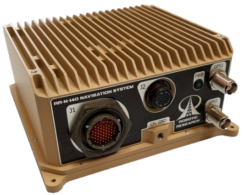
Photo: Robotic Research

Photo: Robotic Research

The RR-N-140 navigation system provides accurate, absolute and relative 3D localization information for ground vehicles of all sizes. It features dual-antenna GNSS for zero-speed heading detection and redundancy. The device delivers exceptional localization performance in GPS-denied or compromised areas. It is designed specifically for use on unmanned ground vehicles and is customizable to incorporate a wide variety of sensor inputs into the navigation solution.
Robotic Research, www.roboticresearch.com

GNSS sensors

Combines numerous interfaces to speed system integration
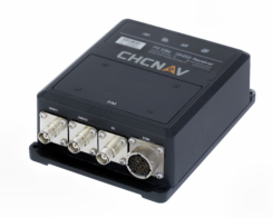
The P2 Elite GNSS sensor. (Photo: CHC Navigation)

The P2 Elite GNSS sensor. (Photo: CHC Navigation)

CHC Navigation’s new P2 GNSS sensor series provides high-accuracy positioning and heading in a compact, rugged enclosure. The series is suitable for a wide variety of applications such as reference stations, marine systems, unmanned navigation, industrial automation, robotics and machine control. The P2 GNSS series is designed to significantly reduce system integration efforts by combining numerous connectivity interfaces including RS232, low-latency PPS output, Ethernet, CAN bus protocol and a comprehensive web interface for configuration set-up. The series integrates the latest GNSS technology in a rugged IP67 and lightweight enclosure. It delivers reliable, uninterrupted, high-accuracy, real-time positioning and heading measurements. The P2 GNSS sensor offers cost-effective and powerful real-time kinematic (RTK) positioning. The P2 Pro GNSS adds a dual-antenna input for precise heading data. The P2 Elite integrates additional 4G and UHF modems to provide a powerful, all-in-one GNSS sensor.
CHC Navigation, www.chcnav.com


TRANSPORTATION

Correction stream

Data enables precision positioning

After 2020, Super Cruise will will be available on all General Motors brands (Photo: GM)

After 2020, Super Cruise will will be available on all General Motors brands (Photo: GM)

RTX Auto is a GNSS software library for use in safety-critical automotive applications. The RTX Auto library can be integrated with any GNSS device and enables the decoding of Trimble’s RTX correction stream for centimeter-level absolute positioning accuracy. It works with other on-vehicle sensors to deliver a certified positioning solution that satisfies advanced driver assistance systems (ADAS) and autonomous driving requirements. It provides RTX-based absolute positioning for General Motors’ Super Cruise, a hands-free driving system for the freeway. After 2020, Super Cruise will will be available on all General Motors brands.
Trimble, trimble.com

Smart antenna

Atlas-capable for marine markets

Photo: Hemisphere GNSS

Photo: Hemisphere GNSS

The Vector V200 single-frequency, multi-GNSS smart antenna with integrated Atlas L-band is designed for general marine applications and markets. Powered by Hemisphere’s Crescent Vector technology, the V200 multi-GNSS compass system utilizes GPS, GLONASS, BeiDou, Galileo and QZSS (with future firmware upgrade and activation) for simultaneous satellite tracking to offer heading, position, heave, pitch and roll output. With support for NMEA 0183 and NMEA 2000, the V200 provides accurate position and heading information to autopilots, chart plotters and other general marine navigation applications.
Hemisphere GNSS, www.hemispheregnss.com

Driver safety solution

Security for intelligent driving

Photo:

Photo: Quectel

The Proactive Security Solution for Intelligent Driving will enhance safety by supporting ADAS and driver monitoring systems (DMS). It integrates Quectel multi-mode LTE Cat 6 smart modules SC600Y/SC600T and an artificial intelligence (AI) algorithm from a third party to realize ADAS and DMS capabilities including monitoring irregular driving behaviors, conducting precise detection of vehicles and traffic signs, sending warnings of potential risks and more. For ADAS, it can precisely identify and locate vehicles, pedestrians, lanes and traffic signs and will send alerts to drivers if an imminent collision or an unintended lane departure is detected. The DMS supports facial recognition and detection, and is able to monitor driver attentiveness and measure eye blinks as well as head movements so that drivers will receive warnings of distractions, smoking, yawning or looking around.
Quectel Wireless Solutions, www.quectel.com

Automotive module

Aimed at urban lane accuracy

The ZED-F9K module is designed to keep cars in their lanes. (Photo: u-blox)

The ZED-F9K module is designed to keep cars in their lanes. (Photo: u-blox)

The ZED-F9K GNSS and dead-reckoning module brings continuous lane-accurate positioning to challenging urban environments. Building on the F9 platform, the module offers both high-precision multi-band GNSS and inertial sensors. It combines the latest generation of GNSS receiver technology, signal processing algorithms and correction services to deliver down to decimeter-level accuracy within seconds. The real-time kinematic (RTK) receiver module receives GNSS signals from all orbiting constellations. The inertial sensors constantly monitor changes in the moving vehicle’s trajectory and continue to deliver lane-accurate positioning when satellite signals are obstructed, such as in parking garages, tunnels, urban canyons or forested areas. The module’s accuracy and low latency make it suitable for automotive OEMs and Tier 1 automakers developing V2X (vehicle-to-everything) communication systems. By continuously sharing their location, V2X systems help increase overall road safety and reduce congestion.
u-blox, www.u-blox.com


UAV

Inertial navigation

Geo-referencing solution improves UAV-based surveying

The Quanta UAV. (Photo: SBG Systems)

The Quanta UAV. (Photo: SBG Systems)

The Quanta UAV series is a line of inertial navigation systems (INS) dedicated to UAV-based surveying integrators. The small, lightweight and low-power INS is offered with two levels of accuracy. Quanta UAV and Quanta UAV Extra have been developed for compact lidar to high-end beyond-visual-line-of-site (BVLOS) mapping solutions. They provide precise orientation and centimeter-level position data both in real time and in post processing, eliminating the need for ground control points and reducing the need for overlaps. SBG’s post-processing software Qinertia gives access to offline real-time kinematic (RTK) corrections from more than 7,000 base stations in 164 countries.
SBG Systems, www.sbg-systems.com

CNPC radio prototype

Being tested as command and non-payload control UAS radio

Photo: Allison Barwacz

Photo: Allison Barwacz

SkyLink is an L-band frequency-modulated CNPC radio intended for point-to-point or networked BVLOS UAS operations. uAvionix has focused on minimizing size, weight, and power consumption (SWaP) while maximizing range and spectrum efficiency. The current 50-gram 10-Watt prototype is testing successfully at ranges exceeding 40 miles at low altitude. uAvionix is testing under an experimental transmit license and approval from the Federal Communications Commission and Federal Aviation Administration, respectively.
uAvionix, uavionix.com

Thermal drone

Designed for solar farm inspections

Photo: SenseFly

Photo: SenseFly

The senseFly Solar 360 UAV is designed to enable the automated and efficient inspection of solar farms. Created in collaboration with software company Raptor Maps, the efficient thermal drone solution enables the automatic assessment of solar plant performance at a sub-module level. Created by combining eBee X fixed-wing drone technology, senseFly’s Duet T thermal mapping camera and Raptor Maps software, senseFly Solar 360 is a fast and fully automated drone. It can be integrated into solar management workflows without requiring either drone piloting skills or the manual analysis of aerial solar-farm data. Solar-farm inspection can be reduced from days to hours, with inspection of utility-scale solar farms completed more quickly, easily and accurately.
SenseFly, www.sensefly.com
Raptor Maps, raptormaps.com

Remote operations

Cloud-based, enables BVLOS
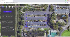
Photo: FlytBase

Photo: FlytBase

FlytGCS is built for subject-matter experts, drone operations managers and UAV operators who wish to automate, simplify and scale their missions. To support automated BVLOS missions, FlytGCS offers features such as connectivity and control over 4G/LTE/5G, live high-definition video feed, fleet management, unlimited missions, remote gimbal control, pre-flight checklist and geofence, mission planner and cockpit view from a web dashboard. FlytGCS is a hardware-agnostic solution that helps securely deploy drones using a mobile app (for DJI drones) or onboard single-board computers (for Ardupilot and PX4 drones).
FlytBase, flytgcs.live

Inspection drone

Collects data in dangerous areas

Photo:

The Elios 2 is a collision-tolerant drone for indoor inspections. (Photo: Flyability)

The Elios 2 UAS is designed for inspection tasks. Routine inspection jobs indoors, underground and around complex pipework become quicker, safer and are fully documented by high-resolution video and stills. The Elios 2 includes a rotatable thermal and high-definition visual camera payload, 10,000-lumen oblique lighting system, and reversible rotors that enable the UAV to back out of tricky situations. The drone’s geodesic-like cage makes it collision-tolerant and enables flight in restricted areas such as refinery enclosures, mines, vats, cargo holds and nuclear containment vessels.
Flyability, www.flyability.com


SURVEY

Battery upgrade

Long-life battery for extended fieldwork

Photo: Geneq

Photo: Geneq

SXblue receivers now have an extended-life battery equipped with 4 Li-ion rechargeable cells that boost its capacity from 3900 mAh to 6000 mAh. When fully charged, the battery can last up to 16 hours depending on the SXblue model and Bluetooth connectivity — an up to 50% increase. The colored LEDs for the battery charge indicator have been enhanced for a better contrast. With only a 6-mm increase in thickness and the same weight as previous models, the user will not notice any change in handiness and ergonomics. The new battery is compatible with all past SXblue II and III models and current iSXblue II+ GPS, SXblue II+ GPS, iSXblue II+ GNSS, SXblue II+ GNSS and SXblue Platinum.
Geneq, geneq.com

Fieldwork tablet

Captures detailed images

DT301X-TR rugged tablet. (Photo: DT Research)

DT301X-TR rugged tablet. (Photo: DT Research)

The DT301X-TR rugged tablet includes an Intel RealSense 3D camera. The lightweight military-grade tablet is built to enhance precision for bridge and construction inspections, 3D surveying and mapping of underground utilities. It provides multi-frequency GNSS real-time kinematic (RTK) with carrier phase for mapping and positioning, and supports GPS, GLONASS, BeiDou, Galileo and QZSS. An optional foldable antenna supports high-accuracy field work, which can be measured with RTK GNSS positioning directly or used to connect to an external antenna for higher precision.
DT Research, www.dtresearch.com

GNSS Receiver

Dual-antenna receiver with heading
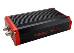
Photo: Tersus GNSS

Photo: Tersus GNSS

The David Plus dual-antenna GNSS receiver offers centimeter-accurate positioning and heading for intelligent transportation, construction, machine control, precision agriculture and navigation. Designed for efficient and rapid integration, the compact, lightweight receiver tracks GPS, GLONASS and BeiDou signals: GPS L1/L2, GLONASS L1/L2, BeiDou B1/B2 from the primary antenna, and GPS L1/GLONASS L1 or GPS L1/BeiDou B1 from the secondary antenna. The modular and flexible design can provide robust positioning and heading accuracy in a compact footprint for UAVs and other smaller autonomous projects.
Tersus GNSS, www.tersus-gnss.com

Tilt compensation

Android and Windows compatible

Screenshot: Trimble

Screenshot: Trimble

Siteworks Software version 1.1 features GNSS tilt-compensation functionality and support for the Android operating system, meaning field workers can use smartphones or tablets. Contractors can run Siteworks on either Windows 10 or Android. Using Trimble Siteworks and a Trimble SPS986 GNSS smart antenna, construction surveyors can take measurements faster and perform more efficient stakeouts. It is designed to shield magnetic interference and can be used effectively anywhere on a construction site. Construction surveyors can capture accurate points without leveling the pole. Three modes support tilt compensation, so contractors can record accurate points while standing, walking or driving the site in a vehicle.
Trimble, www.trimble.com

RTK receiver

Multi-band centimeter-accuracy

Photo: Emlid

Photo: Emlid

The Reach RS2 is a multi-band GNSS receiver that features a built-in LoRa radio, a 3.5G modem, and a survey app for iOS and Android. The receiver determines a fixed solution in seconds and provides positional accuracy down to several millimeters. It tracks GPS/QZSS (L1, L2), GLONASS (L1, L2), BeiDou (B1, B2), Galileo (E1, E5) and SBAS (L1C/A), and reliably works in RTK mode on distances up to 60 kilometers and 100 kilometers in PPK mode. A multi-feed antenna with multipath rejection offers robust performance even in challenging conditions. RINEX raw data logs are compatible with OPUS, CSRS-PPP, AUSPOS and other PPP services so users can now get centimeter-precise results.
Emlid, emlid.com

Publicerad den Lämna en kommentar

Research Roundup: Using UAVs as GNSS satellites

Real-time real-world testbed for new signals

By Daniel S. Maier, Thomas Kraus, Daniela E. Sánchez, Ronny Blum and Thomas Pany, Universität der Bundeswehr München

Testbed with UAVlite, Rx antennas 1 and 2 and the multistation. (Image: Authors)

Testbed with UAVlite, Rx antennas 1 and 2 and the multistation. (Image: Authors)

This research paper presents an update of the authors’ real-time real-world testbed for new GNSS signals. It includes experience gained in setting up an airborne pseudolite, UAVlite, to analyze the code- and phase-ranging performance and to test navigation message authentication schemes.

UAVlites transmit GNSS-like signals free from any local transmitter multipath, in contrast to ground-based transmitters. A software-defined radio allows easy broadcast of new navigation signals, which can be tested in real environments.

Purpose. To improve GNSS signals, it is important to test and analyze signal performance under various conditions and harsh environments. This is done mainly with computer simulation. However, a simulation always relies on assumptions and simplifications of a real-world problem.

Therefore, the authors are developing a flexible, cost-efficient and highly adjustable test system, usable for real test scenarios. With this system, researchers can investigate GNSS signal structures, range performance, authentication methods, channel coding and signal behavior under foliage, blockage, jamming, spoofing and other interferences.

Testbed Setup. Key elements include a UAVlite, two ground stations and a composite binary offset carrier signal. The system has demonstrated decimeter code-range accuracy and millimeter phase-range accuracy. Performance of a Galileo Open Service Navigation Message Authentication implementation was also analyzed.

The testbed has potential in the field of signal analysis and optimization, especially in multipath, channel coding, authentication or robustness against jamming, spoofing or other interference for existing GNSS signals, and for developing potential new GNSS signals.

This paper was presented at ION-GNSS+ 2018. See www.ion.org/publications/browse.cfm.