Publicerad den Lämna en kommentar

GNSS, GIS help small town utilities operate efficiently

Photo: Trimble

Photo: Trimble

Small towns and cities face tight budgets for operating and maintaining public utilities. By sharing resources for common activities, a city can improve cost efficiency in its gas, electric, water and sewer services. In southern Minnesota, the city of New Ulm has modernized its approach to utility asset location and identification management. The effort is reducing costs and improving service for its 13,000 residents.

For more than a decade, the New Ulm Public Utilities group used a computer-aided design (CAD)-based system to track assets for six different utilities. After evaluating its approach for asset mapping, the city transitioned to a geospatial information system (GIS) which provided an opportunity to streamline data collection and management across all of the city-owned utilities.

The city turned to the Trimble Positions Desktop add-in software for Esri ArcGIS Desktop. The approach enables New Ulm field technicians to use Trimble TerraSync field software and Trimble Geo 7X GNSS handhelds for data collection for utility assets and then process the GNSS data in Trimble Positions Desktop. Using this method, the city can provide customized field workflows needed by the different utilities while delivering completed information to a single, centralized GIS database.

In addition to recording the locations and attributes of utility assets, the Trimble solution helps New Ulm technicians return to specific assets when needed. Using real-time GNSS positioning, field crews can navigate directly to specific assets. “Looking for a shutoff valve during a snowstorm isn’t easy,” said New Ulm GIS technician John Bendix. “The Trimble handhelds help them find an asset quickly.”

Bendix uses the Trimble solution to manage connectivity and geographic relationships for new assets. Assets connected to a feature (such as pipes connecting to a manhole) can be automatically adjusted as needed when new field data is checked into the database.

Publicerad den Lämna en kommentar

A straightforward explanation of oblique

How are oblique views derived from aerial imagery?

Typically, a camera takes a field of view of 120 degrees (+/– 60 degrees either side of centerline). The nadir is straight down +/– 5 degrees either side, but everything beyond is considered oblique imagery.

Overlapping imagery is required to ensure clean images and to reduce the angle of obliquity. Too much of an oblique angle causes parallax, which distorts the image, so it is usual for imagery to overlap by 70% each pass, meaning that 30% either side of center is used, but everything except for a small path considered nadir is double imaged.

However, in the case of stereographic imagery, which is required for building a 3D mesh, the overlap has to cover the centerline of the last flight path, so the flights must be much closer together.

Oblique imagery allows 3D meshes to be created, which is a huge benefit to geospatial analysis. It allows the actual terrain to be measured not in a straight line, but in an actual topographic line that includes elevation changes for point-to-point distance.

Additionally, straight lines work when everything looks flat, but in reality straight lines are rare, and point-to-point measurements often have to take advantage of the existing terrain, avoiding steep terrain and aiming to stay on the highest ground to avoid marshy areas.

Oblique imagery also allows for mensuration, which is the measurement of the vertical based on the trigonometry of the sensor’s position and height compared to the target’s angle. More than one oblique image of the same target area allows for stereographic imagery for building the 3D meshes and seeing in 3D. Without the magic of oblique imagery, GIS would be a 2D science.

Publicerad den Lämna en kommentar

UAS enhances utility co-op’s GIS efforts

Photo: Topcon

Photo: Topcon

An electric cooperative that serves more than 33,000 member customers in Lakeside, Ariz. — including the White Mountain Apache Tribe — is using an unmanned aerial system (UAS) to enhance the utility’s GIS effort, working with UAS specialist Skynetwest. Noah Ruiz started Skynetwest in 2015 to provide aerial photographic and videographic services, but seeing the potential of UAS he began making the pivot to high-value data retrieval.

Initial work for the Navopache Electric Cooperative (NEC) included an inspection of an area’s substations. Conducted on a day in which the winds were blowing at 20+ mph, with most other aircraft, the flight would have been extremely risky if not scrapped.

Skynetwest used an Intel Falcon 8+ Drone, Topcon Edition. Windspeed limits for the Falcon 8+ in GPS mode are set at 26 mph; in height mode that threshold is extended to windspeeds as high as 35 mph.

The Falcon 8+ has triple-redundancy inertial measurement units (IMUs), double-redundant compasses, dual-constellation GPS, eight propellers and two batteries. Built into the aircraft’s software is an algorithm that detects the electromagnetic frequencies coming off of power lines and tells the IMUs which one it wants to switch from, which GPS it wants to use, and which compass it wants to use.

The aircraft’s stability is key not only for power line work but also for items like inspection of oil and gas components. For inspection applications — close-up inspections to detect millimeter-sized damage, fine hairline cracks, leaks or heat power losses, for example — the Falcon 8+ payload consists of a Panasonic Lumix DMC-ZS50 camera for true-color RGB images and the FLIRTau 2 640 thermal imaging camera for infrared imaging. The hybrid RGB + 14-Bit RAW data inspection payload combines a near-infrared camera with a high-resolution digital camera mounted in parallel.

The mapping package Skynetwest uses includes a 36-megapixel RGB camera (Sony Alpha 7R) and delivers both orthophotos and 3D models in Topcon ContextCapture software, powered by Bentley Systems.

Upon completion of the substation project, using ContextCapture and Agisoft PhotoScan software, Skynetwest stitched together all of the images it had gathered to create a georeferenced 3D model of that substation. NEC is looking into building more 3D representations of the entire grid and ultimately hoping to build a complete 3D spatial record down to nuts and bolts — all with survey grade data.

Publicerad den Lämna en kommentar

Launchpad: UAV fuel cells, lidar scanners, OEM boards

A roundup of recent products in the GNSS and inertial positioning industry from the August 2019 issue of GPS World magazine.

GNSS module

Ultra-low-power for wearables
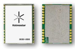
Photo: Kolmostar

Photo: Kolmostar

The JEDI-200 reduces the energy for one position fix by up to 150x compared to traditional GNSS sensors, providing a positioning solution for location-based internet-of-things applications.JEDI-200 specification highlights include 10-mW ultra-low-power consumption (measured) at 1-Hz navigation rate; 1-second ultra-fast time-to-first-fix from cold start, and 2-meter CEP high positioning accuracy. It supports GPS and BeiDou. It offers 100-byte compressed ephemeris (EPH) to enable A-GPS with speedy download via low-power wide-area network (LPWAN) technologies such as LoRaWAN and narrowband internet of things (NB-IoT).
Kolmostar, www.kolmostar.com

Inertial navigation

For GPS-denied environments

Photo: Emcore

Photo: Emcore

The EMCORE EN-300 precision fiber-optic inertial measurement/navigation unit is a high-accuracy inertial system designed to be form, fit and function compatible with a legacy equivalent, but with better performance needed for GPS-denied navigation, precise targeting and line-of-sight stabilization. The EN-300 incorporates EMCORE’s proprietary integrated optics devices to enhance performance. The internal signal processing provides full stand-alone or aided navigation, and as an option can provide standard IMU delta velocity and delta theta. With the option of full navigation capability including coning and skulling compensation and sophisticated Kalman filtering, the unit also is able to statically find north to less than one degree through gyrocompassing.
Emcore, www.emcore.com

GNSS board

For positioning and heading

Phantom 40. (Photo: Hemisphere GNSS)

Phantom 40. (Photo: Hemisphere GNSS)

The Phantom 40 positioning board is the first Lyra-based offering in a line of low-power, high-precision boards. Its multi-frequency, multi-GNSS receiver processes 700 channels with access to Hemisphere’s Atlas GNSS global corrections network. The 60 x 100 mm module with 24-pin and 16-pin headers is a significant upgrade for existing designs using this industry-standard form factor. The new Lyra II digital ASIC and Aquila wideband RF ASIC designs will be available with the new board, as well as Cygnus interference mitigation technology.
Hemisphere GNSS, www.hemispheregnss.com

Helical antennas

Available in housed and embedded OEM versions

The new helical antenna in both housed (left) and unhoused form. (Photo: Tallysman)

The new helical antenna in both housed (left) and unhoused form. (Photo: Tallysman)

The first three products of a new range of helical antennas include the HC871, HC872 and HC600. The active GNSS helical antennas feature a low-current, low-noise amplifier (LNA), and include integrated low-loss pre-filters, to protect against harmonic interference from high amplitude interfering signals, such as 700-MHz band LTE and other near in-band cellular signals. The HC871 is a housed, dual-band, active GNSS antenna supporting GPS L1/L2, GLONASS G1/G2, Galileo E1, and BeiDou B1 (25 grams). The HC872 is a housed, dual-band, active GNSS antenna supporting GPS L1/L2, GLONASS G1/G2, Galileo E1, BeiDou B1, and L-Band services (36 grams). The HC600 is a housed, passive Iridium antenna (18 grams).
Tallysman, www.tallysman.com

Fiber extension KIT

Carries signals up to 10 kilometers
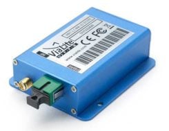
ViaLiteHD Blue OEM module, one of the available formats for the GPS RF over fiber link. (Photo: VitaLink)

ViaLiteHD Blue OEM module, one of the available formats for the GPS RF over fiber link. (Photo: VitaLink)

ViaLite’s new GNSS/GPS Fiber Extension Kit has been qualified for use with Microsemi’s timing and synchronization products, and carries timing signals over optical fiber links to 10+ kilometers. The kit includes the ViaLiteHD GPS Link, designed to provide a remote GNSS/GPS signal or derived timing reference to equipment located where there is no reception, such as inside buildings, tunnels and mines. The kit is suitable for GPS, Galileo, GLONASS and BeiDou bands, and the links provide a wide dynamic range with negligible signal degradation from noise or interference.
ViaLite, www.vialite.com


Lidar scanner

3D mobile scanner for urban areas, roads

Photo: Viametris

Photo: Viametris

The second generation of the vMS3D lidar scanner is now more compact and simplified in both electronic and ergonomic terms to make it more robust and stable in adverse conditions and challenging environments. Despite being lighter, the second generation offers the same technological capacities as its predecessor, but is simpler to use and can be mounted on a vehicle in minutes. The system component (including the sensors) and the element to affix the device to the vehicle (the frame) previously formed one unit, but are now separated in a design that limits vibrations and prevents any strain on the mechanics during acquisition. The scanner’s receiver is a Septentrio AsteRx-m2a and its inertial measurement unit is an SBG Systems Ellipse2-D.
Viametris, www.viametris.com

Job-site monitoring

Real-time 3D construction management gets remote support

Sitelink 2.0. (Photo: Topcon)

Sitelink 2.0.
(Photo: Topcon)

Sitelink 2.0 is the latest edition of Topcon’s real-time 3D job-site monitoring and management system. The update includes a new pay-as-you-go point-based service model, new features to Sitelink Support Desk, and a new Haul Truck application. Remote configuration via the support desk allows Topcon personnel to directly access and configure receiver components on connected machines, while simultaneously retaining an active remote session of Topcon’s 3D-MC grade-control software for machine control.
Topcon, www.topconpositioning.com

Data collector

Connected smartphone for the field

Photo: Trimble

Photo: Trimble

The TDC600 handheld is an ultra-rugged, all-in-one smartphone and GNSS data collector for geographic information system (GIS) and field inspection applications. The rugged handheld runs on Android 8.0 and has a bright sunlight-readable 6-inch display, 2.2-GHz processor, 4-GB memory and an enhanced-capacity all-day battery. It supports the Trimble Catalyst GNSS positioning service that delivers subscription-based accuracy on demand for Android devices. Its built-in receiver supports GPS, GLONASS and BeiDou plus satellite-based augmentation system (SBAS) capabilities for real-time positioning. It is rugged for GIS users in organizations such as environmental management, utilities and government agencies. Wi-Fi, Bluetooth 4.1 and 4G LTE cellular connectivity support data and voice calls, so field workers can use the TDC600 as they would any consumer smartphone, communicating between the field and office, sending emails and texting.
Trimble, www.trimble.com

Vehicle scanner

1,200 scan lines per second

Photo: Cepton

Photo: Cepton

The SORA-P60 is designed to provide accurate 3D scans and to enable automated classification of objects and volumetric scanning, including high-velocity vehicle scanning and classification. Cepton’s Micro-Motion Technology (MMT) lidar in combination with its edge-compute hardware SORA-Edge makes it a powerful, mobile object classification and volumetric measurement device that can send its data over Ethernet, Wi-Fi or LTE to a central processing server. The SORA-P60’s three scan lines, each scanning at 400 Hz, enable accurate scanning for classification of objects traveling at highway speeds — 400 Hz translates to a scan line every 5 centimeters for an object traveling at 50 miles per hour. For example, users can measure the size of a tow hitch and trailer on a vehicle traveling on a highway in real time. The SORA-P60 sensor is free of rotational or frictional components, making it impervious to mechanical wear and tear. In addition, the new SORA-P60 features rugged housing designed to withstand harsh environments, cold climates and salt spray.
Cepton Technologies, www.cepton.com


UAV

Long-flight demonstrator

Completed maiden flight

The XQ-58A Valkyrie demonstrator, a long-range, high subsonic UAV completed its inaugural flight March 5, 2019, at Yuma Proving Grounds, Arizona. (Photo: U.S. Defense Department)

Photo: U.S. Defense Department

The XQ-58A Valkyrie from National Security Solutions provider Kratos completed its maiden flight on March 5 at Yuma Proving Grounds in Arizona. Kratos Unmanned Aerial Systems (KUAS) and the Air Force Research Laboratory (AFRL) partnered on the development of the XQ-58A Valkyrie. During its 76-minute maiden flight, the UAV completed its test objectives. The runway-independent UAV is capable of long-range flights at high-subsonic speeds. Its development falls within AFRL’s Low Cost Attritable Aircraft Technology (LCAAT) portfolio, which has the objective to break the escalating cost trajectory of tactically relevant aircraft.
Kratos Defense & Security Solutions, www.kratosdefense.com

Fuel cells

Long-duration power solution for commercial UAVs

Photo: Ballard

Photo: Ballard

The FCair hydrogen fuel cell can extend UAV flight time to up to 90 minutes, almost three times that of lithium-ion battery-powered drones. The product line includes FCair-600 and FCair-1200 liquid-cooled fuel-cell power systems, with built-in hybrid battery control and charging and delivering 600 and 1200 watts of power, respectively. These systems are in ongoing field trials, having previously been proven in harsh environments and at high altitudes. FCair includes a hydrogen fuel-cell power system, hydrogen storage vessels, pressure regulators, refueling solutions and hydrogen gas supply. The product line supports commercial UAV manufacturers and operators in the delivery of fuel-cell-powered UAV benefits, including: three times the flight duration of batteries; five times the reliability and a fraction of the noise of small internal combustion engines; and significantly reduced operational expenses.
Ballard, www.ballard.com

Lidar platform

Compact for uav deployment

Photo: Teledyne

Photo: Teledyne

The CL-90 is a lightweight compact lidar platform for UAV deployment. It features exceptional canopy penetration, offering low-noise, high-quality survey-grade data to deliver high-quality performance in data accuracy and point precision. The CL-90 provides full lidar performance across the entire operating altitude range of the UAV, and offers a variable field-of-view capability that eliminates the need for multiple passes over a target.
Teledyne, www.teledyne.com

Drone countermeasure

Lightweight, compact handheld gun

Photo: DroneShield

Photo: DroneShield

DroneGun MKIII is a portable pistol-shape drone jammer weighing under 2 kg. DroneGun MKIII is designed to be an alternate product rather than a replacement for the previously released DroneGun Tactical unit. It has a shorter effective range of 500 meters versus 1–2 kilometers for DroneGun Tactical. DroneGun MKIII can be used in combination with other DroneShield products, including the RfPatrol body-worn detection device and the DroneSentinel stationary multi-sensor detection system.
DroneShield Ltd., www.droneshield.com

Publicerad den Lämna en kommentar

European Navigation Conference brings GNSS community together

ENC logo

ENC logo

The 28th edition of the European Navigation Conference (ENC 2020) will be held May 11-14 at the International Congress Center in Dresden, Germany.

The conference is hosted by the German Institute of Navigation (DGON). Because of the rapid development of analog and digital technologies, there is increasing progress in performance of GNSS.

The conference brings together scientists, engineers and international experts to discuss new ideas, latest research results, future developments and new applications. High-level presentations will allow each participant to receive an in-depth view on the current status of satellite navigation technology. Topics include:

  • GNSS Updates & Policies
  • GNSS Algorithms & Techniques
  • Resilience and Autonomy
  • Multi-Sensor & Data Fusion
  • Aviation & Marine Navigation
  • Space & Science Applications
  • Mobility and Transportation

Speakers. Keynote speakers will be Julia Klöckner, Federal Minister of Food and Agriculture, and Dr. Pascale Ehrenfreund, German Aerospace Center, chair of the Executive Board.

Expo. A technical exhibition provides an opportunity for companies, agencies and research institutions to display their offerings; it will be directly placed in the conference area.

Abstracts. The European Navigation Conference aims to provide a forum for both academic and industrial professionals in navigation topics from all over the world and to bring together academicians, researchers, engineers, system analysts, graduate and undergraduate students with government and non-government organizations to share and discuss both theoretical and practical knowledge. Experts are invited to submit outstanding and valuable original research papers and participate in the technical exhibition during the conference. The deadline for abstracts is Nov. 1, 2019.

About Dresden. The city of Dresden is located at the river Elbe and has a long and colorful history. Although Dresden is a relatively recent city of Slavic origin, it is well-known as the capital and royal residence for the Electors and Kings of Saxony, who for centuries furnished the city with cultural and artistic splendor. After the reunification process in 1989, Dresden has regained importance as one of the cultural, educational, political and economic centers of Germany and Europe.

Learn more at the conference website.

Publicerad den Lämna en kommentar

Drotek releases Sirius RTK GNSS rover F9P

Image: Drotek

Image: Drotek

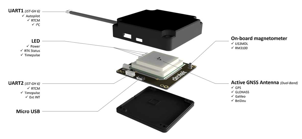
Drotek Electronics is now offering the F9P Sirius RTK GNSS Rover, which is designed to be mounted on a moving vehicle. The u-Blox ZED-F9P module inside provides 1-cm position accuracy, a convergence time under 10 seconds and a navigation update rate up to 20 Hz.

The new Sirius RTK GNSS Rover F9P has a built-in active antenna patch. It receives GPS, Galileo, Beidou and GLONASS signals, providing additional accuracy. The F9 Sirius Rover is designed to fit most setup designs as well as integrate easily into a vehicle. Its six-pin JST-GH connector makes it plug-and-play with the Pixhawk Pro 3 autopilot.

Publicerad den Lämna en kommentar

Swift Navigation expands Skylark precise positioning for autonomous vehicles

Image: Swift Navigation

Image: Swift Navigation

Skylark is now available across the contiguous United States, enabling safe and lane-level accurate positioning.

Swift ​​Navigation’s network-connected Skylark precise positioning service is now available throughout the United States. Full contiguous U.S. (CONUS) coverage reduces initialization times to seconds, ensuring high-accuracy, high-integrity positioning is available when customers need it.

Swift ​​Navigation is ​​a San Francisco-based tech firm providing centimeter-accurate GNSS positioning technology for autonomous vehicles, and the maker of the Piksi Multi and Duro GNSS receivers.

Skylark is built for autonomy at scale and delivers lane-level precision, with safety-of-life integrity, required by mass-market automotive and autonomous applications. Skylark is a scalable network delivering a continuous stream via the cloud of robust, reliable, multi-constellation, multi-frequency corrections, with the latency, security, precision and reliability required for safety and autonomy.

“Since Skylark was introduced last year, the Swift network team has been hard at work deploying infrastructure across the country,” said Rob Hranac, COO of Swift Navigation. “This extensive network helps remove hurdles in precise positioning for our customers and we look forward to partnering with those customers as we expand Skylark internationally.”

Skylark is designed to address the needs of automotive original equipment manufacturers (OEMs) by supporting ASIL-rated (Automotive Safety Integrity Level) systems and Ntrip2 (Networked Transport of RTCM via Internet Protocol) connections in cloud reference station (CRS) mode. It is state space representation (SSR) ready — an emerging industry format.

Skylark is hardware-independent, giving customers a choice in today’s rapidly improving and commodifying the GNSS sensor ecosystem. OEMs are able to benefit from the lane-level positioning Skylark delivers using a host of third-party receivers in addition to Swift’s Piksi Multi and Duro receivers.

Unlike legacy real-time-kinematic (RTK) services designed for smaller regions and precise point positioning (PPP) services that suffer from slow convergence times, Skylark is a high-performance hybrid nationwide U.S. network that delivers initialization times in seconds, better than 10 centimeters of accuracy and integrity required by the most demanding safety-of-life critical applications.

When used with Swift’s Starling positioning engine, Skylark is capable of delivering protection levels (PL) down to 1 meter and target integrity risk (TIR) down to 10-7/hour. Engineered for automotive functional safety standard ISO 26262 (ASIL B), Skylark is designed and built from the ground up to support next-generation GNSS applications, connected car, V2X and advanced driver assistance systems (ADAS).

Skylark packages GNSS precise positioning as an affordable subscription service for ease in deployment for large-scale autonomous vehicle fleets.

Publicerad den Lämna en kommentar

Early earthquake warnings: GNSS could enable 10-second alerts

In February 2016, the USGS rolled out the second-generation ShakeAlert Earthquake Early Warning test system in California. The diagram shows how the system would operate. (Image: USGS)

In February 2016, the USGS rolled out the second-generation ShakeAlert Earthquake Early Warning test system in California. The diagram shows how the system would operate. (Image: USGS)

Previous research suggests that not until halfway through a rupture (90 seconds for a magnitude-9 quake) can magnitude be predicted. Geodetic GNSS data could bring this down to as little as 10 seconds — greatly extending and enhancing earthquake early warning systems.

How soon can we predict the magnitude of an earthquake?

Seismologists Diego Melgar of the University of Oregon and Gavin Hayes of the U.S. Geological Survey (USGS) in Golden, Colorado, tackled this question by chance while Melgar was writing code to simulate earthquakes to check the accuracy of Earthquake Early Warning systems in the Pacific Northwest.

He reached out to Hayes, who curates a database for the USGS that contains “source time functions,” which show how the seismic energy release changes through time as the earthquake ruptures.

As a rupture grows, the speed of growth changes, and source time function captures that change. Melgar and Hayes focused on the acceleration of the energy release in large (M>7) and great (M≥9) earthquakes, and found that acceleration wobbled between 2 and 5 seconds after the quakes began.

However, with the approximately 250 M≥7 earthquakes in their database, they found that between 10 and 15 seconds after rupture began, these larger earthquakes started to behave similarly, and that behavior scales with their final magnitude, Hayes said. “In other words, the acceleration at 10 to 15 seconds is diagnostic of their final magnitude.”

Earthquake ruptures sputter along for about 10 seconds, after which the big ones accelerate, according to Melgar and Hayes. Three different source time function databases showed the same consistency.

Vertical movement near the source of large earthquakes can be between 3 and 5 meters, according to data from GNSS geodetic receivers. Analysis of near-source GNSS data from 12 M≥7 earthquakes showed that for the first 10 seconds after the first indication of an earthquake was recorded, the earthquakes made almost immeasurable movements. But between 10 and 15 seconds, the amount of vertical displacement began to rapidly diverge for the different magnitude groupings. By 20 to 25 seconds, the vertical movement was distinct.

Previous research indicated roughly half the source duration must pass before an accurate prediction could be made. Cutting the prediction time down to 15 seconds would be invaluable to earthquake early warning systems and tsunami prediction algorithms, where every second counts.

GNSS sensors are installed onshore across the globe, but the majority of megathrust earthquakes occur underwater. To integrate Melgar and Hayes’ findings effectively into earthquake early warning systems would require sensors installed along the seafloor, they noted. “You [would also] need to have fiber-optic cables from shore to the bottom of the ocean, winding around with sensors, and then eventually coming back on shore, and that’s not cheap,” Melgar said.

An additional 10 to 30 seconds of warning to a city or nuclear reactor of an imminent quake would have enormous benefits. But if the hypothesis is wrong, using it now would lead to a greater rate of false alarms and missed quakes, eroding the value of these warnings to society. Melgar and Hayes acknowledged their finding needs to be rigorously tested.


Summarized from Temblor’s website. The Temblor Android app and website provide earthquake, landslide, tsunami and flood information.

Citation
Tripathy-Lang A. (2019), “Can the size of a large earthquake be foretold just 10 seconds after it starts?”. Temblorhttp://doi.org/10.32858/temblor.029

Publicerad den Lämna en kommentar

Rugged tablet offers 3D imaging for field work

Photo: DT Research

Photo: DT Research

DT Research has designed a new rugged tablet with 3D imaging that is purpose-built for 3D mapping with a built-in GNSS module.

The DT301X has an Intel RealSense Depth camera that provides real-time 3D imaging combined with dual-frequency GNSS module for real-time mapping and positioning. The digital images are better than high-definition standard, and are suitable for construction building information management (BIM) graphics.

The DT301X rugged tablet is compatible with existing applications with Microsoft Windows 10 IoT Enterprise operating systems for flexible integration, and it brings together the advanced workflow for data capture, accurate positioning and data transmitting.

Key features of the DT301X

  • Highly durable. IP65 and MIL-STD-810G rated tablet in a slim case offers the versatility to be used in the field, office and vehicles.
  • Indoor/outdoor display. A high brightness 10.1-inch touchscreen offers flexible viewing in a wide range of lighting.
  • Wi-Fi and Bluetooth. Long-range Bluetooth for 1000-foot range and 4G LTE mobile broadband for the latest in high-speed communications.
  • High performance. Intel 8th-generation Core i5 or i7 processor offers high-performance while still being energy efficient.
  • Hot-swappable batteries. With high-capacity 60- or 90-watt hot-swappable batteries, the DT301X keeps working continuously.
Publicerad den Lämna en kommentar

Volkswagen, Ford join on self-driving cars

Photo: Argo AI

Photo: Argo AI

In July, Volkswagen AG and Ford Motor Co. provided updates on their development alliance announced in January.

The automakers plan to collaborate on autonomous vehicles, among other programs. Together, they are investing $2.6 billion in Pittsburgh startup Argo AI, which is developing a self-driving technology platform. Ford first invested in Argo two years ago.

The investment includes the resources of VW’s Autonomous Intelligent Driving Group (AID), valued at $1.6 billion. AID will become Argo AI’s European operation.

Volkswagen and Ford hope to achieve a self-driving platform that can be scaled comparatively quickly. Argo AI’s objectives are to

  • build for scale.
  • architect the software to be production quality.
  • have automotive-grade sensors and computers.
  • fully integrate their product with OEMs and automakers.

A benefit to having the Argo AI system on more vehicles means the AI will obtain data through daily operation, enabling it to grow smarter and better.

Argo AI has successfully tested its driverless vehicles in five U.S. cities: Pittsburgh, Palo Alto, Detroit, Miami and Washington, D.C.