Publicerad den Lämna en kommentar

Orolia Defense & Security completes acquisition of Talen-X

Talen-X has joined Orolia Defense & Security to expand its capabilities and resources, enabling the development of more advanced position, navigation and timing (PNT) solutions and to offer more robust customer support.

Photo: Orolia

Orolia Defense & Security has completed the acquisition of Talen-X, a U.S. company specializing in advanced GNSS solutions and interference, detection and mitigation (IDM) technologies.

“Orolia Defense & Security is excited to bring on Talen-X as they offer a complementary portfolio of solutions and bring many years of advanced PNT experience to the team. We look forward to continuing their growth by providing additional resources and capabilities, while ensuring the growth and success of their current customers,” said Hironori Sasaki, president of Orolia Defense & Security.

In early 2019, Orolia Defense & Security spun off as a separate entity from its parent company Orolia, with the mission of providing resilient PNT solutions and custom engineering services to U.S. government agencies, U.S. defense organizations, and their contractors.

Orolia Defense & Security operates as a proxy-regulated company, free of foreign ownership, control or influence (FOCI). As such, Orolia Defense & Security is approved to work on the full spectrum of U.S. government classified and unclassified projects and is positioned to support strategic partnerships in the development of key PNT technologies for the defense market.

“Our culture of innovation, together with our demonstrated testing capabilities, will complement Orolia’s technology expertise and significantly enhance the reliability, performance and safety of military operations,” said Tim Erbes, Orolia Defense & Security’s Director of Engineering. The acquisition also enables Talen-X’s existing resources, operations and capabilities to be scaled and accelerated to better support the warfighter.

At the Modern Day Marine and Association of the U.S. Army (AUSA) exhibitions, Orolia Defense & Security is showcasing its latest technologies such as the BroadSim Wavefront GNSS simulator, ThreatBlocker jamming/spoofing detection and protection device and BroadShield threat detection software.

Authorized for use with U.S. military signals such as GPS L1/L2, P, Y, and M-Code, Orolia’s simulation and IDM solutions serve unique and challenging program requirements.

Publicerad den Lämna en kommentar

Hemisphere GNSS launches GNSS receiver, smart antenna at Intergeo 2019

Hemisphere GNSS has introduced its multi-frequency, multi-GNSS S621 GNSS survey smart antenna and R620 GNSS receiver at Intergeo 2019 in Stuttgart, Germany, and ION GNSS+ 2019 in Miami.

S621 GNSS survey smart antenna

The S621 GNSS survey smart antenna is a complete redesign of Hemisphere's previous generation version, the S321+. (Photo: Allison Barwacz)

The S621 GNSS survey smart antenna is a complete redesign of Hemisphere’s previous generation version, the S321+. (Photo: Allison Barwacz)

The S621, powered by the company’s Phantom 40 GNSS OEM board, is a complete redesign of Hemisphere’s previous generation version, the S321+.

According to the company, the S621 processes and supports more than 800 channels with flexible and scalable simultaneous tracking of every modern and planned GNSS constellation and signal including GPS, GLONASS, BeiDou (including Phase 3), Galileo, QZSS, IRNSS, SBAS and Atlas L-band.

The S621 combines Hemisphere’s Athena GNSS engine and Atlas L-band correction technologies with a new WebUI. It meets IP67 requirements and is immune to magnetic interference. It is designed for use in land or marine survey, GIS, mapping, construction or other applications requiring high-performance precision and positioning, the company added.

“The S621 represents the advanced technology, durability, and ease-of-use that our customers have come to expect,” said Miles Ware, director of marketing at Hemisphere. “By redesigning this system from the ground up with increased functionality and management capabilities, we are offering unbeatable value.”

R620 GNSS receiver

The R620 GNSS receiver is a complete refresh of Hemisphere's previous version, the R330. (Photo: Allison Barwacz)

The R620 GNSS receiver is a complete refresh of Hemisphere’s previous version, the R330. (Photo: Allison Barwacz)

The R620 GNSS receiver, powered by the Vega series, is a complete refresh of Hemisphere’s previous version, the R330, and includes an all-new low-profile ruggedized enclosure.

According to Hemisphere GNSS, the R620 GNSS receiver processes and supports more than 1,100 channels and offers flexible and scalable simultaneous tracking of every modern and planned GNSS constellation and signal including GPS, GLONASS, BeiDou (including Phase 3), Galileo, QZSS, IRNSS, SBAS and Atlas L-band.

The R620 combines Hemisphere’s Athena GNSS engine and Atlas L-band correction technologies with status LEDs and a WebUI. It also comes equipped with UHF (400 MHz and 900 MHz) radio, cellular modem, Bluetooth and Wi-Fi.

“With its all-new design and feature set, the R620 GNSS receiver is Hemisphere’s offering to what the market desires — smaller machine, lower cost and less power,” Ware said. “The receiver boasts a feature- and performance-packed combination of greater performance, improved robustness and excellent value.”

Publicerad den Lämna en kommentar

Defense in front of UAV development

The MQ-9B SkyGuardian will participate in NASA-sponsored flight tests in 2020. (Photo: General Atomics Aeronautical Systems)

The MQ-9B SkyGuardian will participate in NASA-sponsored flight tests in 2020. (Photo: General Atomics Aeronautical Systems)

The defense segment is going from strength to strength — despite a phase not too long ago when defense spending appeared to be dropping. Widespread drone use received a boost with specialized equipment developed for defense forces applications.

The Predator Advances

The General Atomics Predator has gone from a long-distance loiter-and-observe UAV to frontline precision-strike capability, and has been adopted by many military forces around the world.

From first flights in 1994 to initial production in 1997, the Predator has now evolved into many configurations equipped with piston engine, turboprop and jet; line-of-sight radio and satellite command and control; synthetic aperture radar and multi-spectral targeting system; video, TV and thermographic cameras; and laser designators and other payloads.

From pure reconnaissance to various strike and attack configurations, the names have also changed. Predator, Reaper, Gray Eagle, Avenger, Protector, Guardian and SkyGuardian have a host of RQ/MQ designations. For instance, In the RQ-4 Global Hawk name, the “R” means reconnaissance, the “Q” means unmanned aircraft, and the “4” is the series.

The SkyGuardian version of the Predator is a certifiable variant anticipated to ultimately become fully authorized for controlled airspace. It will take part in the NASA Systems Integration and Operationalization (SOI) demonstration program in mid-2020, which will highlight commercial UAS missions using larger drones in the national airspace.

The Predator family has now been evolving for more than 25 years. Unfortunately, the popularity of the Predator family of military unmanned aircraft has led to recent headline news about Predators shot down in the Gulf of Hormuz, or crashed in Afghanistan — such is the price of success!

Global Hawk Gathers Intel

The Northrop Grumman Global Hawk has become a U.S. mainline, high-altitude intelligence gathering asset, deployed by both the U.S. Air Force (RQ-4 Global Hawk) and Navy (MQ-4C Triton). Other friendly nations have also shown various levels of interest in acquiring variants, including Germany, Australia, Canada, Japan and South Korea.

Northrop Grumman has reintroduced the Firebird as a contender in the airborne intelligence, surveillance and reconnaissance (ISR) field. The Firebird can be configured as unmanned (ground control), autonomous or piloted, and has payload flexibility through open architecture, plug-and-play integration.

The North Dakota UAS test range facility at Grand Sky has initiated procurement of two Firebird UAVs, which they intend to supply to their customers for mapping, inspection and monitoring applications using their extensive, long-range BVLOS capabilities.

Skyborg Equipped with AI

And then there’s this U.S. Air Force Skyborg program, which aims to drag the most possible out of artificial intelligence (AI) and automation in an airborne fighter support roll. Kratos has flown the drone hardware a couple of times – the XQ-58A Valkyrie is a “low-cost” unmanned aircraft designed to fly alongside front-line attack aircraft like the F-35 and F-18.

The Air Force Research Laboratory (AFRL) is researching the technology, new sensors, payloads and networking capability these drones will be outfitted with to fly alongside manned fighter jets.

A whole slew of other extremely capable drones are already being operated by the U.S. Army and Navy in a variety of support roles.

The DroneGun Tactical in use in an operational scenario. (Photo: Photo: DroneShield)

The DroneGun Tactical in use in an operational scenario. (Photo: Photo: DroneShield)

Anti-Drone Detection and Prevention

On the flip side, an entirely new related industry segment has come about in the last several years, usually adapting existing radar, sound, infrared or other ground detection systems.

This segment is aimed at circumventing unwelcome drone encroachment over sensitive facilities. Airports, governments, prisons, and energy and water utilities are among the facilities who want to prevent unwanted drones penetrating their airspace.

Solutions may be portable and short range, or ground-based and longer range, with the capability to take down an invading drone or detect where it came from and provide significant warning time.

One solution uses an attack drone that ensnares an intruder-drone in a net and brings it the defender’s location to support second-level investigations. Whatever the solution, drone defense is a growing field.

Publicerad den Lämna en kommentar

Tallysman debuts VeroStar precision antenna, helical antennas at Intergeo 2019

The VSP600L VeroStar supports the full GNSS spectrum, as well as L-band correction services. (Photo: Allison Barwacz)

The VSP600L VeroStar supports the full GNSS spectrum, as well as L-band correction services. (Photo: Allison Barwacz)

Tallysman has released its VSP600L VeroStar precision antenna at Intergeo 2019, which took place Sept. 17-19 in Stuttgart, Germany.

The VeroStar supports the full GNSS spectrum, as well as L-band correction services. The antenna provides low elevation satellite tracking with a high efficiency radiating element, the company said.

It features a light, compact and robust design, in addition to low axial ratios from zenith to horizon. According to Tallysman, the VSP600L VeroStar also provides high receive gain over the full GNSS spectrum from low GNSS band (1164MHz to 1300MHz) L-band correction services (1539MHz to 1559MHz) to high GNSS band (1559MHz to 1610 MHz).

The antenna also boasts a tight phase center variation, low current, invariant performance Fromm m+3 to 16VDC and high gain-to-noise at low elevation angles.


“The most unique feature of the VeroStar antenna is the high gain at low elevations,” Allen Crawford, director of key accounts at Tallysman, told GPS World at the show. “It can track low elevation satellites with a really high signal level, which is really important for those using correction services coming off of geostationary satellites. So as you go further away from the equator, you’re dealing with some very small link margins and you need those extra up to 4dB higher signal strength that this antenna provides.”

According to the company, it will soon be releasing embedded models of the VSP600L VeroStar.

At the show, the company also released an updated line of its helical antennas, including the single frequency HC771, dual frequency (plus L- band corrections) HC882 and the triple band (plus L- band corrections) HC975. The original line of helical antennas, which includes the HC600, HC871 and HC872, were released earlier this year.

Publicerad den Lämna en kommentar

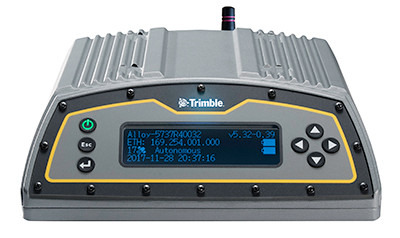
Trimble Pivot, Alloy GNSS receiver now support BDS-3 signals

Photo: Trimble

Photo: Trimble

Trimble has added capabilities to its real-time network (RTN) portfolio, including the Trimble Pivot Platform and the Trimble Alloy GNSS reference receiver.

The new capabilities will enable operators to continue to meet the ongoing demand from surveyors, mapping professionals and precision farmers for accurate, reliable corrections derived from real-time networks.

The announcement was made at Intergeo 2019, the world’s largest conference on geodesy, geoinformatics and land management, taking place this week in Stuttgart, Germany.

Boosting RTN performance. A well-established network software, the Pivot Platform manages and controls small, mid-size and countrywide GNSS networks. By applying sophisticated atmospheric models to reduce systematic errors, highly accurate GNSS corrections are generated and made available for a wide range of field applications.

BDS-3 now supported

Both Pivot and Alloy now access BeiDou Generation III (BDS-3) signals.
Trimble Pivot version 4.3 has been enhanced to track and store BDS-3 — RTN operators worldwide now have the ability to provide their customers with additional satellite signals to offer even more robust and reliable positioning for their applications. This update also includes a simplified Chinese user interface, providing easy-to-use software operations for Chinese RTN operators.

Released in 2018, the Alloy GNSS reference receiver was designed with the processing power needed to deliver high-quality data from multiple GNSS constellations. Alloy version 5.42 firmware tracks all available and planned GPS Block IIIA L1C and BDS-3 signals, empowering operators with a full GNSS constellation dataset.

“These updates keep the Trimble Pivot Platform and Alloy on a future driven path,” said Mark Richter, strategic marketing director, Real-Time Networks and Services portfolio for Trimble’s Advanced Positioning Division. “Our focus is to continue to deliver enhancements influenced by market demands and advancements in technology, which deliver next-generation RTN hardware and software to our customers.”

The Trimble Pivot Platform and Trimble Alloy GNSS reference receiver updates work in conjunction to provide quality GNSS corrections to network operators and end users.

Trimble real-time networks and services

Trimble RTN networks and services are a widely used GNSS infrastructure solution. Spanning a variety of applications and industries worldwide, Trimble’s hardware is specifically developed for RTN real-world environments while the software integrates seamlessly into the RTN solution for exceptional real-time performance.

The flexibility of Trimble’s solution enables users to collect, manage and analyze complex information faster and easier, improving productivity and efficiency.

Publicerad den Lämna en kommentar

GPS Innovation Alliance adds 4 affiliates

Four national organizations join alliance dedicated to furthering GPS innovation, creativity and entrepreneurship 

GPS Innovation AllianceThe GPS Innovation Alliance (GPSIA) has added four national organizations representing a variety of sectors. The organizations join GPSIA’s affiliates program by supporting the alliance’s goal of protecting, promoting and further enhancing GPS — one of the world’s most important enabling technologies.

The new affiliates are:

  • American Council of the Blind (ACB)
  • U.S. Geospatial Executives Organization (U.S. GEO)
  • NENA: The 9-1-1 Association
  • Subsurface Utility Engineering (SUE) Association

“The Alliance has grown in both size and ambition since its inception over six years ago and with increased adoption of GPS-enabled technologies, our dependence on GPS will only continue to grow,” said GPS Innovation Alliance Executive Director J. David Grossman. “Building on the launch of the bipartisan and bicameral GPS Caucus this past March, we look forward to working with these new affiliates in bringing heightened awareness to the critical importance of GPS to our nation’s economy.”

These organizations join GPSIA’s existing affiliates including:

  • Association of Equipment Manufacturers (AEM)
  • American Trucking Associations (ATA)
  • Association for Unmanned Vehicle Systems International (AUVSI)
  • Boat Owner’s Association of the United States (BoatUS)
  • General Aviation Manufacturers Association (GAMA)
  • National Association of Manufacturers (NAM)
  • National Society of Professional Surveyors (NSPS)

The following are comments from representatives of the newly announced affiliates:

Clark Rachfal, Director of Advocacy and Governmental Affairs, American Council of the Blind (ACB)

“Precise GPS technology is enabling a world where people who are blind may navigate their surroundings with greater confidence and live more independently. The American Council of the Blind is pleased to partner with the GPS Innovation Alliance to ensure this vital technology is available and accessible to all people who are blind in order to increase their economic opportunity and quality of life.”

John M. Palatiello, Founder and President, U.S. Geospatial Executives Organization (U.S. GEO) 

“The acquisition, processing, analysis, and application of geospatial data, and its use in geographic information systems (GIS) and other platforms, is greatly dependent on GPS and GNSS. U.S. GEO, representing executives of the nation’s geospatial firms, strongly supports our GPS system and is honored to be part of the GPS Innovation Alliance to assure its continued benefit to the U.S. economy and our quality of life.”

Dan Henry, Director of Government Affairs, NENA: The 9-1-1 Association: 

“Locating a 9-1-1 caller used to be as simple as searching a database for the street address associated with the caller’s phone number, but with over 80% of all 9-1-1 calls now coming from mobile phones, tracking down a caller’s location is no longer so easy. When callers are unable to convey their location to 9-1-1, public safety telecommunicators turn to mobile phones’ sophisticated location-finding system; GPS is the foundation of this system. 9-1-1 saves millions of lives every year — many of these lives would not have been saved if not for GPS.”

John Berrettini, President, Subsurface Utility Engineering (SUE) Association

“The SUE Association is comprised of firms, organizations and individuals engaged in the provision of subsurface utility engineering (SUE) services where the role of GPS/GNSS availability and utilization is vital to field data collection, analysis, and processing. Partnering with the GPS Innovation Alliance helps to meet our organizational charge to promote knowledge, best practices, and the exchange of information in the profession; ensure the protection of public health, welfare and safety; and educate clients and other stakeholders of the value and benefits of subsurface utility engineering services.”

The GPS Innovation Alliance was founded by Deere & Company, Garmin International, Inc. and Trimble Inc. The alliance recognizes the ever increasing importance of GPS and other GNSS technologies to the global economy and infrastructure and is firmly committed to furthering GPS innovation, creativity and entrepreneurship by seeking to protect, promote and enhance the use of GPS.

Publicerad den Lämna en kommentar

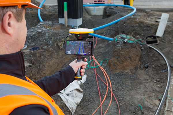
Trimble handheld AR SiteVision takes data visualization outdoors

Photo: Trimble

Photo: Trimble

Trimble has introduced its Trimble SiteVision system, an outdoor augmented reality (AR) solution that enables users to visualize 2D and 3D data on virtually any project site with cellular or internet connectivity for easier and more efficient planning, collaboration and reporting.

Combining hardware and software in an integrated, lightweight handheld or pole-mounted solution, users can view 3D models and assets in a real-world environment at a 1:1 scale, from any angle or position.

The system consists of:

  • Hardware: The Trimble SiteVision integrated positioning system integrates the Trimble Catalyst DA1 antenna, electronic distance measurement (EDM) rangefinder and power management into a lightweight, handheld device that connects to a user-supplied Android mobile phone.
  • Software Subscription: Available to single users on a monthly or yearly basis. The SiteVision software subscription combines Trimble’s high-accuracy positioning services and cloud-based processing technology to create a centimeter-accurate AR system. The system leverages Trimble cloud-based processing to manage and deliver data and design models.

SiteVision enables users to visualize digital models from a wide range of data collection, design and constructible modeling tools in open industry-standard formats including IFC and LandXML.

For civil projects, SiteVision accurately visualizes data from Trimble’s Quantm, Business Center and Novapoint; design data from Civil 3D and Bentley OpenRoads; and GIS data from Esri ArcGIS software.

Photo: Trimble

Photo: Trimble

SiteVision powers building information modeling (BIM) projects with open data from Trimble’s Constructible BIM solutions including SketchUp and Tekla, and BIM data from Autodesk Revit and AutoCAD software. For utility companies, PLS-CADD power line design, Distribution Design Studio (DDS) and other industry-specific design data is also supported.

Using Trimble Connect cloud-based hosting, SiteVision can access models from all stages of the lifecycle of infrastructure and buildings—from initial concepts of roads or buildings through the operations and maintenance phase of the assets—to increase collaboration, enhance work accuracy and ultimately improve operations and utilization.

SiteVision simplifies complex concepts by allowing users to blend digital content with real-world environments. For example, city planners can visualize a new building design in the exact spot it is to be erected, a work crew could identify the exact position of underground cables or pipes before digging, an electric utility can confirm placement of poles and lines with customers and crews, or a construction supervisor could assess the progress of heavy equipment by visualizing actual work performed against the site plan.

“It’s easier to understand complex ideas when we can see them in a real-world context,” said Mark Nichols, general manager at Trimble. “SiteVision improves our understanding of projects and worksites with a handheld device that is accessible to a wide range of users. Augmented reality is now ready for everyday use in a wide range of applications.”

Trimble SiteVision is available to order now through Trimble’s authorized distribution channels for Civil Engineering and Construction, Geospatial and Buildings.

Publicerad den Lämna en kommentar

Hemisphere GNSS debuts OEM boards with next-gen ASIC technology

Hemisphere GNSS has introduced its next-generation digital ASIC, RF ASIC, interference mitigation platforms, and five all-new positioning and heading OEM boards — the first products incorporating these powerful technological advancements.


Hemisphere is showcasing its new boards and technology at the Intergeo expo (hall 3, booth C3.030) and conference in Stuttgart, Germany, and the ION GNSS+ conference (booth 411) in Miami, Florida, both taking place this week.


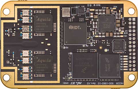
Hemisphere’s Lyra II digital ASIC and Aquila wideband RF ASIC designs optimize performance and provide the ability to track and process more than 800 channels for position-only (the Phantom series boards) and more than 1,100 channels for position and heading (the Vega series boards).

Phantom 40. (Photo: Hemisphere GNSS)

Phantom 40. (Photo: Hemisphere GNSS)

This new ASIC technology offers flexible and scalable access to every modern and planned GNSS constellation and signal, including GPS, GLONASS, Galileo, BeiDou, QZSS, IRNSS, SBAS and Hemisphere’s Atlas L-band.

Signal support and tracking for AltBOC and BS-ACEBOC, BeiDou phase 2 and phase 3, L5 and QZSS/L6 (L6-D and L6-E) are also available.

The Lyra II and Aquila ASIC technology provides the foundation for a new GNSS receiver chipset architecture that significantly reduces the number of board components, thereby reducing complexity, improving reliability, and dramatically lowering power consumption.

Cygnus interference mitigation. The powerful technology platform also includes Hemisphere’s new Cygnus interference mitigation technology with built-in digital filtering capabilities and spectrum analysis. The new Cygnus technology provides enhanced anti-jamming, interference detection, and mitigation.

“This new technology platform and OEM boards represent significant improvements upon previous generation technology and hardware,” said Farlin Halsey, president and chief executive officer of Hemisphere. “With these outstanding advancements in our core technology and hardware, our customers and OEM partners are future-proofed and have flexibility and scalability with the highest-value access to all modern and planned signals.”

Vega 28. (Photo: Hemisphere GNSS)

Vega 28. (Photo: Hemisphere GNSS)

The next-generation Lyra II, Aquila, and Cygnus technologies are available with the new Phantom 20, Phantom 34, Phantom 40, Vega 28, and Vega 40 OEM positioning and heading boards.

The Phantom 20, 34, and 40 positioning boards are the first Lyra II-based offerings in a line of all-new, low-power, high-precision OEM boards. They are multi-frequency, multi-GNSS receivers that boast more than 800 channels including access to Hemisphere’s Atlas GNSS global corrections network and offer serial, USB, Ethernet (Phantom 40-only), and CAN connectivity for ease of use and integration.

The Phantom 20 (41 x 72 mm module with 20-pin header), Phantom 34 (41 x 71 mm module with 34-pin header), and Phantom 40 (60 x 100 mm module with 24-pin and 16-pin headers) are significant upgrades for existing designs using these industry-standard form factors and offer power consumption of less than 1.8 W when tracking all signals, including L-band.

The Vega 40 and 28 are the first introductions in a line of all-new, low-power, high-precision, positioning and heading OEM boards. The multi-frequency, multi-GNSS Vega 40 and 28 GNSS receivers offer access to more than 1,100 channels including Hemisphere’s Atlas GNSS global corrections network.

The Vega 40 is a 60 x 100 mm module with 24-pin and 16-pin headers and is the ideal upgrade for existing designs using this industry-standard form factor. The Vega 28 is a 45 x 71 mm module with 28-pin header and is the smallest GNSS OEM heading module ever offered to the geospatial market by Hemisphere.

Publicerad den Lämna en kommentar

Bluesky debuts MetroVista city mapping service for Europe at Intergeo 2019

The Bluesky MetroVista range includes high-resolution imagery combined with high-accuracy, wide-scale 3D models. (Image: Bluesky)

The Bluesky MetroVista range includes high-resolution imagery combined with high-accuracy, wide-scale 3D models. (Image: Bluesky)

Bluesky International has launched its international MetroVista city mapping service for Europe at Intergeo 2019, which took place Sept. 17-19 in Stuttgart, Germany.

The mapping service incorporates the Leica CityMapper hybrid airborne sensor, which can simultaneously capture vertical and oblique aerial photography, as well as lidar.

According to the company, the Bluesky MetroVista range includes high resolution imagery combined with high accuracy, wide scale 3D models. Bluesky’s CityMapper also has already been used to capture MetroVista data for cities across the United Kingdomm, including London, Manchester, Newcastle and Bristol.

Bluesky’s CityMapper, used to produce the MetroVista data, includes a traditional vertical camera, as well as survey-grade oblique cameras. The sensor, designed for 3D city modeling and urban mapping, incorporates lidar technology to accurately collect elevation and infrared data.


“Here at Intergeo, we’re showing our MetroVista data sets, which are the city meshes,” Ralph Coleman, sales director at Bluesky, told GPS World. The city meshes are extremely dense, they’re very feature-rich, and they’re vey accurate. They provide a vast range of detail for a massive range of applications.”

Bluesky is a United Kingdom-based aerial survey and geographic data company that produces and maintains digital aerial photography and height data. The company has offices in the United Kingdom, United States and the Republic of Ireland, as well as a production center in India.

Publicerad den Lämna en kommentar

Trimble launches X7 3D laser scanner at Intergeo 2019

The Trimble X7 is designed for surveying, construction, industrial and forensic applications. (Photo: Allison Barwacz)

The Trimble X7 is designed for surveying, construction, industrial and forensic applications. (Photo: Allison Barwacz)

Trimble has released its X7 3D laser scanning system at Intergeo 2019, which took place Sept. 17-19 in Stuttgart, Germany. According to the company, the system is designed to enable professionals of all scanning levels to quickly and easily capture precise 3D scanning data to produce high-quality deliverables.

The X7 is designed for surveying, construction, industrial and forensic applications. The scanner features Trimble X-Drive technology, survey-grade self-leveling and a smart calibration system.

“We are really excited to bring the X7 to the market,” Gregory Lepere, marketing director, optical and imaging, Trimble, told GPS World. “It’s a very simple solution but offers a lot of smart technology. Every time you turn the instrument on, the automatic calibration will start, so you’re guaranteed to have all of the specifications all of the time.”

It also integrates streamlined workflows to provide automatic registration of point cloud data in the field with Trimble Registration Assist.

“The feature bringing the most simplicity to the solution is the Trimble Registration Assist technology, which is a full registration in the field, bringing all of the scans together thanks to self-leveling IMU technologies combined with cloud-based software,” Lepere said.


Survey applications

For surveyors and geospatial professionals, the X7 provides fast and balanced performance in both indoor and outdoor environments and is ideal for industrial survey/tank calibration, civil infrastructure, general surveys, road intersection surveys, utilities, mining, and historical documentation and renovation, Trimble said.

The X7 is fully integrated with the Trimble Perspective software, which enables scans and images to be captured, fully registered together, refined, controlled and exported to a variety of established data format for Trimble and non-Trimble software suites.

Building design and construction applications

For users in building design and construction, the X7 assists with measurement problems and improves field productivity for a broad range of applications in architecture, engineering and construction industry projects.

For these applications, the X7 is fully integrated with Trimble Field Link software to provide streamlined workflows specific to the building construction industry — from scanning to modeling to field layout.

Forensics applications

According to Trimble, the X7 can perform in demanding conditions and offers easy setup for investigators and law enforcement. It also pairs with the company’s Trimble Forensics Capture software.

The Trimble X7 is expected to be available in the first quarter of 2020.

In addition, the company announced the availability of its SiteVision augmented reality system at Intergeo.