Publicerad den Lämna en kommentar

SXblue ToolBox Application now available on iOS

Image: SXblue

Image: SXblue

Following the launch of its Android application in 2018, Geneq is now launching an iOS version of its SXblue ToolBox for iOS-compatible SXblue devices.

The application was developed with special interest paid to raw data recording and NTRIP service connection.

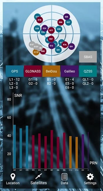
With the SXblue ToolBox iOS application, the user can analyze the position data provided by the SXblue receiver, as well as location metadata.

More important for SXblue clients, the application can record, save and transfer raw data from the GNSS receiver, thereby allowing post-processing activities. The application also acts as a NTRIP client, capable of connecting to a NTRIP server for real-time kinematic (RTK) corrections, and thus allows the receiver to issue very accurate location information.

Receiver configuration is easy through the application, with the ability to set up and save user-defined commands for subsequent use. The settings include constellation to be used, differential source, NTRIP login credentials list and more.

In addition, the iOS application includes a series of audible and visual alarms that are user-configurable to determine the thresholds of information provided by the SXblue GNSS receiver.

The main features of the iOS SXblue ToolBox application are:

  • Display of location information and quality of positioning data
  • Skyplot of all-in-view constellations: GPS, GLONASS, Galileo BeiDou, QZSS, SBAS
  • Recording of raw data and data transfer
  • NTRIP/DIP client to receive RTK corrections
  • Terminal to send commands and view the output data of the SXblue device
  • Audible and visual alarms
  • Activation of options and licenses via the application.
Publicerad den Lämna en kommentar

User question of the Month – Sep’19

After the summer break, we’re back with a new user question.

This month, we want to focus on documentation. Specifically, we’d like to know how you learn how to use QGIS.

The survey is available in English, Spanish, Portuguese, French, Ukrainian, and Indonesian. If you want to help us translate user questions into more languages, please get in touch on the community mailing list!

Nyhet från QGIS, orginal inlägg

Publicerad den Lämna en kommentar

Launchpad: M-code receiver, modules and software

A roundup of recent products in the GNSS and inertial positioning industry from the September 2019 issue of GPS World magazine.


Vehicle tracker

Uses u-blox to detect panic breaking

Photo: u-blox

Photo: u-blox

Arvento’s imt.x1 has a six-axis gyro sensor that can sense three-dimensional movement caused by emergency acceleration, panic braking and directional yaw and drift. With connectivity options including dual CANBus and Bluetooth, the system is eCall compatible and captures and provides data for accident analysis and other vehicle tracking functions. The system also uses the next-generation powerful Arm-based microcontroller. The system’s high position sensitivity and accuracy are based on integration of u-blox’s 2G, 4G and 5G-ready cellular modules as well as GNSS modules.

Arvento, arvento.com; u-blox, u-blox.com

Dual-band GNSS module

Provides mass-market positioning

Image: Quectel

Image: Quectel

The compact LC79D module features concurrent multi-constellation GNSS receivers on dual GNSS bands. It uses L1 and L5 for GPS, Galileo and QZSS, L1 band for GLONASS and BeiDou, and L5 band for IRNSS. It can generally increase the number of visible satellites, significantly improve positioning drifting when driving in urban canyons and enhance positioning accuracy. Embedded with a low-noise amplifier (LNA) and multi-tone active interference, the module provides high sensitivity and reliable anti-jamming capability, ensuring exceptional acquisition and tracking even in weak signal areas.

Quectel Wireless Solutions, quectel.com

Development kit

For testing and interating mosaic

Photo: Septentrio

Photo: Septentrio

The mosaic development kit helps integrate mosaic into an existing system. Mosaic is a compact high-precision multi-frequency GPS/GNSS module that brings precision and reliability of high-end multi-frequency GNSS to mass-market applications. Its light weight and low power consumption makes mosaic suitable for robotics, automation, telematics and wearables. The kit supports connectivity through internet, COM ports, USB 2.0 and an SD Card slot. Mosaic provides Advanced Interference Mitigation (AIM+); extensive corrections support for high-accuracy positioning; integrity needed for safety-critical applications such as autonomous vehicles; and a 100-Hz update rate, suitable for robotics and fast-moving vehicles.

Septentrio, www.septentrio.com

Micro INS

For defense, aviation, aeronautics

Photo: Emcore

Photo: Emcore

The EN-2000 is the newest addition to the Emcore-Orion series of micro-inertial navigation (MINAV) systems. It is compact and lightweight, weighing less than 7 pounds, with very low power consumption of 10 watts. It can deliver twice the performance of the EN-1000 with the same form factor. With its low size, weight and power (SWaP), the compact EN-2000 is suitable for unmanned aerial vehicles, unmanned underwater vehicles, unmanned ground vehicles, manned aircraft, rotorcraft and dismounted soldier applications. Its three-axis design uses a solid-state optical transceiver with advanced integrated optics, combined with new field programmable gate array (FPGA) electronics to deliver stand-alone aircraft-grade navigator performance at one-third the SWaP of legacy systems.

Emcore, emcore.com

M-code receiver

Set for 2020 production deliveries
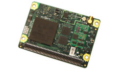
Photo: Collins Aerospace

Photo: Collins Aerospace

The Miniature PLGR Engine – M-Code (MPE-M) GPS receiver is a small Type II form factor ground receiver, and incorporates the company’s recently certified Common GPS Module (CGM). As a drop-in replacement for the thousands of customers using Collins’ Miniature PLGR Engine-SAASM (MPE-S) GPS receiver, the new MPE-M technology provides 10 times stronger anti-jamming capabilities for the direct acquisition of GPS signals than its predecessor. The MPE-M receives the current military Y-code GPS signal along M-code. It provides warfighters with improved security and assured positioning, and it satisfies the U.S. government’s requirement for all military GPS equipment to be M-code capable. It is designed for lightweight, ground-based applications such as radios, blue force trackers, targeting devices, vehicle line-replaceable units (LRUs) and small unmanned aircraft. The MPE-M’s security certification makes the receiver eligible for export to U.S. allies through the Foreign Military Sales (FMS) program.

Collins Aerospace, www.utc.com


Software receiver

Available with usage-based plan

The Catalyst software-defined GNSS receiver for Android phones and tablets is now available with a usage-based service plan: Trimble Catalyst On Demand. The new service plan meets the needs of industries and organizations that need a more flexible payment model. Organizations use Catalyst to record positions, navigate to points, measure relative distance and create digital maps. Trimble Catalyst On Demand provides scalable access to real-time kinematic (RTK)-quality GNSS positioning using a pay-per-use hourly pricing model in addition to the current Catalyst monthly plans. The service also enables automated domain-level email address access, which streamlines license allocation for organizations with a large number of users. (Pictured: Catalyst DA1 antenna).

Trimble, www.trimble.com

Rugged tablet

3D Imaging and built-in gnss

Photo: DT Research

Photo: DT Research

The DT301X is designed for 3D mapping. Its Intel RealSense Depth camera provides real-time 3D imaging combined with a dual-frequency GNSS module for real-time mapping and positioning. The digital images are better than high-definition standard, and are suitable for construction building information management (BIM) graphics. The highly durable IP65 and MIL-STD-810G-rated tablet in a slim case can be used in the field, office and vehicles. A bright 10.1-inch touchscreen provides indoor/outdoor viewing. The tablet includes long-range Bluetooth and 4G LTE mobile broadband for the latest in high-speed communications. An Intel 8th-generation Core i5 or i7 processor offers high performance while still being energy efficient.

DT Research, www.dtresearch.com

Airborne lidar

Mapper for wide-area, mountain, urban and corridor surveys

Photo: Teledyne Optech

Photo: Teledyne Optech

The ALTM Galaxy PRIME wide-area lidar sensor offers collection efficiency, a small form factor and high-quality data sets that meet rigorous USGS lidar standards. It has a 6,000-meter above-ground-level (AGL) collection envelope and 1-MHz on-ground collection rate. Galaxy PRIME includes lidar technology enhancements to increase sensor performance and collection efficiency, improve data quality, and simplify the collection process. It can be used either gyro-stabilized or fixed-mounted, one camera or six, and full waveform or discrete. PulseTRAK technology enables a continuous operating envelope by eliminating data coverage gaps and irregular point density. Applications include wide-area mapping, urban mapping, natural resource management, engineering, infrastructure modeling, and powerline and transportation corridors.

Teledyne Optech, teledyneoptech.com

Imaging sensor

Real-time 3D reality capture

The Leica BLK247. (Photo: Hexagon)

The Leica BLK247. (Photo: Hexagon)

The Leica BLK247 real-time reality-capture device uses sensor fusion technology to detect and report physical changes within a space. It is designed for continuous 3D reality capture, extending capabilities for safety and security applications. The sensor provides real-time situational awareness through edge computing and lidar-enabled change-detection technology. Using artificial intelligence, the BLK247 can tell the difference between still and moving objects — such as a person walking who leaves a suitcase behind — and identify security threats to provide real-time alerts.

Hexagon, hexagon.com

Scientific software

Better data interpretation

Image:: Golden Software

Image:: Golden Software

Version 15 of Grapher has new capabilities to improve the ability to model, analyze and interpret data as well as communicate the results. Grapher users can now access new Fit Curve, Axes and Statistical Plotting capabilities. Also, users are provided greater color customization functions in the latest release. Enhancements give Grapher users a more powerful ability to display and communicate the results of their work to others. The software provides 80 different 2D and 3D plot types for analyzing and displaying scientific data.

Golden Software, goldensoftware.com


Heavy-lift scanning UAV

Ready for longer flights
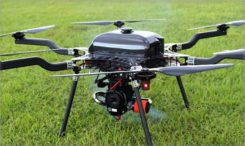
Photo: LiDARUSA

Photo: LiDARUSA

The Harris Aerial H4/H6 Hybrid multicopter is now offered as an integrated package with any Lidar USA scanning system. The Harris Hybrid can provide longer flights with lidar and industrial-grade cameras. The Harris Hybrids use a small generator running on 95 or higher octane fuel to power the UAV for up to five hours.The H6 can carry an A-series high-definition lidar system of 3 kg for 2.5 hours and a V-series of 5 kg up to 1.5 hours. For the lidar operator, this means most projects will require only one or two flights.

Lidar USA, www.lidarusa.com

Commercial drone

Long duration for sensitive tasks

Photo: Impossible Aerospace

Photo: Impossible Aerospace

The US-1 was built with sensitive enterprise and government customers in mind. It was designed from the ground up in the United States with a battery-first approach to enable electric aircraft to compete with conventionally fueled incumbents. The US-1 runs on a secure open-source operating system by Auterion. It provides 78 minutes of flight time and high-resolution optical and thermal cameras. US-1 UAVs have been deployed to fight fires, locate pipeline leaks, and track armed suspects.
Impossible Aerospace, impossible.aero

Auterion, auterion.com

Drone rescue system

Meets ASTM standards

Photo: LiDARUSA

Photo: LiDARUSA

The DRS-M600 reusable parachute safety solution, developed for DJI M600 and DJI M600 Pro, meets specifications of the ASTM F3322-18 standard. The successful completion of the ASTM standard test makes it possible for the Federal Aviation Administration to issue permits for its use on drones over crowds. The ASTM F3322-18 standard is the first standard for parachute systems designed specifically for small UAVs.

Drone Rescue Systems, www.dronerescue.com


GPS/comm radio

WAAS/SBAS with LPV approaches

The GNC 355 is a GPS navigator with localizer performance with vertical (LPV) approach guidance. (Photo: Garmin)

The GNC 355 is a GPS navigator with localizer performance with vertical (LPV) approach guidance. (Photo: Garmin)

The GNS 355 GPS navigator with localizer performance with vertical (LPV) approach guidance gives pilots the benefits of WAAS/SBAS GPS guidance with a modern communications radio. Intended for Class I/II aircraft that weigh 6,000 lbs./2,721 kg. or less, the GNC 355 is certified for more than 700 aircraft makes and models. Aircraft owners can incorporate the GNC 355 into an existing avionics stack because of its standard 6.25-inch wide by 2-inch tall design. The responsive touchscreen display allows pilots to quickly access direct-to functionality, moving map, flight plan, nearest, procedures, waypoint and terrain pages and create customizable data fields and shortcuts for quick, one-touch access to important information. Fully WAAS/SBAS IFR-approach-capable, the GNC 355 gives pilots the benefit of flying LPV, as well as Area Navigation (RNAV) approaches. Many approaches offer vertical approach guidance as low as 200-feet above ground level (AGL).

Garmin, Garmin.com

RTK INS platform

For autonomous vehicles under demanding conditions

Allystar RTK/INS Evaluation Board V1.0. (Photo: Allystar)

Allystar RTK/INS Evaluation Board V1.0. (Photo: Allystar)

The Allystar INS Platform is a dual-antenna, multi-frequency, multi-GNSS inertial navigation system (INS) that delivers accurate and reliable position, velocity and orientation. It combines high-grade, six-axis, temperature-calibrated accelerometers and gyroscopes with a multi-frequency, multi-GNSS engine, the HD9300 series. The HD9300 is a dual-antenna chip-grade real-time kinematic (RTK) GNSS receiver for accurate positioning and heading. The Allystar INS platform contains an on-board sensor-fusion filter, plus navigation and calibration algorithms for different dynamic motions of land vehicles. The Allystar OBD Data Adapter (v1.0) enables users to read and monitor various sensors built into cars, obtaining real-time vehicle speed and gear signals from the on-board diagnostics (OBD) interface, and then output AT (attention) commands by serial port or serial peripheral interface (SPI).

Allystar, www.allystar.com

Publicerad den Lämna en kommentar

SBG Systems provides firmware update for Ellipse

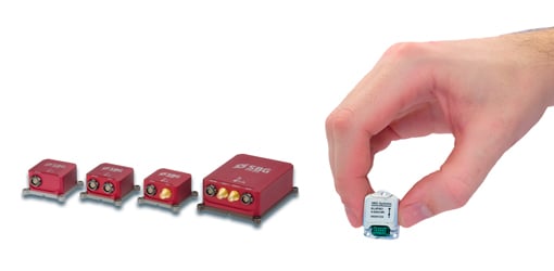
SBG Systems has announced a major firmware update for the Ellipse product line. New features have been added to version 1.7 to enhance performance of the sensor.

Automotive package. New features were developed to better answer needs of the autonomous testing and driving markets. These features include:

  • CAN odometer. Users now have the choice to connect an external odometer (DMI) with pulses or use their car odometer with velocity information. During the installation, users can enter a rough “resolution.” Then, SBG’s inertial sensor refines the odometer installation parameters to automatically obtain the best performance.
  • New outputs. Included are body velocity and slip angle, which calculates the “drift” angle between the vehicle assumed trajectory and its actual (deviated) trajectory.

Fixed lever-arms mode. For precision applications as well as low dynamics, and reduced warm-up time, the new Ellipse firmware allows users to run the Ellipse Kalman filter with no lever-arm estimation. This will ensure centimeter pass-to-pass accuracy for real-time kinematic (RTK) applications and allow operation in lower dynamics while reducing warm-up time.

To precisely calibrate the lever arms, the use of Qinertia Lite can be used to obtain centimeter precise lever arms. For general-purpose applications, the standard mode of operation that refines the lever arms in real time is still available.

Marine applications. The firmware update provides new features for advanced marine applications.

  • DVL aiding support. This helps to reduce drifts from the inertial sensor underwater, providing an interesting opportunity for projects such as short subsea navigation with affordable inertial sensors.
  • New output message (INDYN). INDYN brings support to performance sailing autopilots such as the B&G H5000.

Improved magnetic calibration (sbgCenter). The new sbgCenter embeds a new magnetic calibration algorithm that improves overall performance in challenging calibration while allowing even more difficult calibration conditions. This new calibration procedure also provides improved quality feedback.

The firmware download is protected by a password, the same credentials as for the last version. To request the password, e-mail support@sbg-systems.com.

Photo: SBG Systems

Photo: SBG Systems

Publicerad den Lämna en kommentar

From Animals to Autonomy: RIN gathers experts for top conference

logo: RIN

The Royal Institute of Navigation: International Navigation Conference takes place Nov. 18-21 at the Edinburgh International Conference Centre in Edinburgh, UK.

Navigation and Societal Benefits: From Animals to Autonomy
The International Navigation Conference (INC) offers a unique format, with keynotes morning and afternoon each day, to set the scene for the more in-depth session papers.

Resilient position and precise time are enabling the modern world. INC enables sharing of knowledge and experience to maximize the potential and positive impact of the industry.


Plus:

Pre-INC Training Seminar: Securing Positioning and Timing
On Monday, Nov. 18, RIN is offering a one-day short course to build understanding of satellite navigation vulnerabilities and threats, plus steps to toughen and augment systems.

Learn more, including presenters and to register.


At INC, technology, system and application experts meet with cognitive neuroscientists, human factors, legal, ethical and regulatory experts. Participants feed insights from RIN’s world-leading animal navigation forum and conference, offering insights, perspective and contacts to improve attendees impact and effectiveness.

INC creates value by bringing disciplines together to share knowledge, perspectives and insights. The RIN strives to make INC an enriching experience for all delegates, with a program designed to include plenty of time for networking, including social events on Monday, Tuesday and Wednesday evenings.

RIN aims for each delegate to leave INC with new insights, ideas and contacts.

Session Themes

  • Autonomy and Innovations in Robotics
  • Animal Navigation
  • Resilient PNT
  • Neuroscience and Cognition
  • Human Factors and Wayfinding
  • Innovation: Integrated Sensors and Indoor Navigation
  • Innovation: Artificial Intelligence
  • Innovative Navigation Solutions
  • User Sector Updates: CNI and Maritime
  • Scottish-led Innovation in Positioning, Navigation and Timing
  • Drone Regulation and Protection
  • UK Space and GNSS

For more information, including the programme and keynote speakers, visit the event website.

Publicerad den Lämna en kommentar

RxNetworks extends Location.io service with BeiDou III support

Logo: Rx Networks

Rx Networks Inc., as part of its continued reference network expansion and vendor diversity initiative, has added BeiDou III B1C and B2a signals and messages to Location.io, its feature-rich, modular location platform.

BDS III is available via Location.io in a variety of data formats including regionally optimized, NTRIP, LPP and RRLP, as well as proprietary real-time and predicted formats.

With the addition of BDS III, Location.io is positioned to support mobile devices globally in any configuration, including dual-band or single-band GNSS receivers, and in single or multi-constellation configurations.

“Rx Networks continues to follow up on our promise to deliver Location. Enlightened. products and services,” said Peter Mueller, head of innovation at Rx Networks. “BDS will play a major role in the years to come with the uptake of multiband GNSS in mobile devices including smartphones and internet of things (IoT) devices.”

“The upgrade and expansion of our private global reference network can now offer legacy BDS II signal B1I right up to PRN 63, in addition to the new BDS III B1C and B2a signals, as well as GPS/QZSS/Galileo/GLONASS/NavIC support in L1, L2c and L5/E5. Plus, our network is ready for Galileo E6. This makes Location.io one of the most complete data services available, all with a great Service Level Agreement.”

BDS III will be part of the Location.io software client in early 2020.

Location.io technologies are in use by more than 2 billion smartphones, laptops and wearables worldwide. All Location.io services are delivered from Rx Networks’ geo-redundant and cloud-based service delivery network, ensuring 99.999% service-level availability.

Publicerad den Lämna en kommentar

Trimble, Qualcomm partner on connected vehicle positioning

Companies aim to provide sub-lane-level accuracy to automotive OEMs and Tier 1 suppliers

Image: Trimble

Image: Trimble

Trimble and Qualcomm Technologies, a subsidiary of Qualcomm Incorporated, announced today plans to work together to produce precise-positioning solutions for select automotive applications.

Trimble will work with Qualcomm Technologies to integrate Trimble’s RTX technology with select Qualcomm Snapdragon Automotive 4G and 5G platforms to deliver a highly accurate positioning solution essential for maintaining absolute in-lane positioning.

The new solution will accelerate the adoption of road-level navigation and emergency services applications, as well as satisfy requirements for developing advanced driver-assistance systems (ADAS) and autonomous driving solutions.

The Snapdragon 4G and 5G automotive platforms feature integrated multi-frequency and multi-constellation high-precision GNSS technology. They also support all major global and regional GNSS satellite constellations including GPS, GLONASS, Galileo, BeiDou, and QZSS, operating concurrently on the L1, L2, and L5 frequency bands, including a precise positioning framework.

The framework ensures consistency in access and use of precise positioning information and incorporates the use of GNSS corrections technology.

Tight integration of GNSS functionality in conjunction with the modem reception of the corrections allows for minimum latencies and optimal performance of the precise-positioning solution from the telematics system and provides automakers with a global location platform to meet the requirements of next-generation vehicles.

Trimble RTX technology provides real-time, multi-constellation GNSS corrections and positioning capable of achieving 2-centimeter horizontal accuracy worldwide, compared to uncorrected GNSS positioning that can be accurate to several meters. The combined solution will provide reliable, consistent, high-accuracy positioning, in a broadcast format, to serve even the most precise requirements of the automotive and transportation industries.

“Trimble’s relationship with Qualcomm Technologies establishes a unique alliance between industry leaders, in which both companies are committed to advancing the development of safer, more capable ADAS,” said John Sprivulis, director of autonomous navigation solutions for Trimble’s advanced positioning division. “Together we will offer a solution to the automotive industry that can help accelerate the adoption of precise GNSS positioning in the connected car and transform the way the world drives.”

“Highly accurate positioning is quickly becoming an important element of connected vehicle solutions to support Vehicle-to-Everything (V2X) and other autonomy applications,” said Lars Boeryd, senior director, product marketing, Qualcomm Technologies. “For this very reason, we are working with Trimble to host the RTX precise positioning software library on our Snapdragon Automotive 4G and 5G platforms to offer a robust end-to-end highly accurate position solution for the automotive industry.”

Evaluation kit. An RTX-enabled Snapdragon evaluation kit (EVK) is expected to be available by early 2020, for use by automotive OEMs, Tier 1 suppliers or other stakeholders considering absolute positioning as part of their autonomy solution.

Trimble has also made Trimble RTX Auto an ASIL and ASPICE compliant RTX software library, available to any OEM or supplier who requires a functional safety certified solution.

Publicerad den Lämna en kommentar

Qinetiq, Collins to develop GNSS receivers for UK

QinetiQ and its partner Collins Aerospace have won a £67 million contract with the United Kingdom’s Ministry of Defence (MOD) Defence Equipment and Support (DE&S) to develop multi-constellation satellite receivers under the UK Robust Global Navigation System (R-GNS) program.

The program will deliver critical capability to provide UK Defence with accurate and resilient positioning, navigation and timing (PNT), which will underpin the UK’s ability to undertake 24/7 military operations around the world in demanding and increasingly contested operational environments.

QinetiQ, working with its partner (Collins Aerospace) and sub-contractors (Roke Manor Research, Raytheon Systems Limited, Garfield Microelectronics, Nottingham Scientific Limited, Phixos and a number of other specialist suppliers and manufacturing partners) will work together to provide advanced navigation products that are UK sovereign supplied, low size, weight and power (SWAP) delivering high-accuracy, resilient and secured operational capability.

The use of multi-constellation, multi-service satellite navigation signals, multiple sensors and QinetiQ’s advanced processing technologies will enable secured navigation, ensuring that users and platforms —autonomous land, maritime, air and weapons systems — will be able to navigate accurately, robustly and safely.

“Whether it’s soldiers conducting operations in remote environments or fighter jet pilots flying in contested airspace, our Armed Forces depend on satellite navigation technology,” said Defence Minister Anne-Marie Trevelyan. “These state-of-the-art receivers will help to ensure our armed forces can defend UK interests wherever and whenever they are threatened.”

“Ensuring that UK Forces have the best and most resilient secured navigation capabilities is essential to ensuring that they are able to operate effectively in increasingly challenging operational environments,” Steve Wadey, CEO, QinetiQ said. “We are extremely pleased to be working with MOD, DE&S and DSTL to deliver this critical capability. This programme will exploit QinetiQ’s advanced technologies and, working collaboratively with our partners across the supply base, deliver substantial operational advantage for UK Defence.”

The delivery date for the first R-GNS products is February 2022.


Feature photo: Collins Aerospace

Publicerad den Lämna en kommentar

China adds two more satellites to BeiDou constellation

Photo: Xinhua News Agency

Photo: Xinhua News Agency

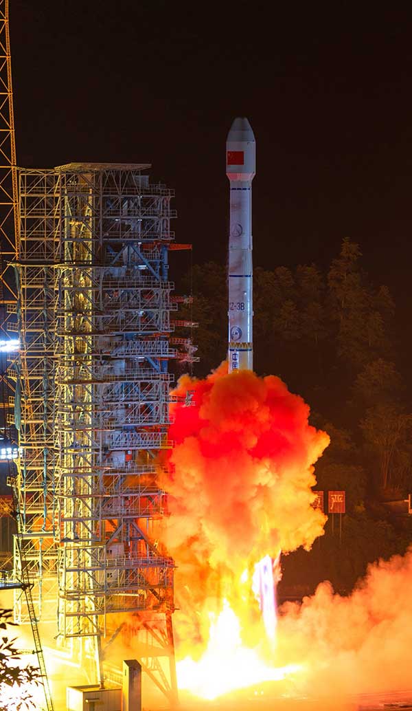
China has launched two more BeiDou III satellites. The launch took place on Sunday, March 23, according to the Xinhua News Agency using a Long March 3B rocket which lifted off from the Xichang space center at 2110 GMT (5:10 p.m. EDT) Sunday.

The satellites have been confirmed as MEO23 and MEO24.

About four hours after liftoff, the upper stage delivered the Beidou satellites into a nearly circular orbit with an average altitude of 13,500 miles (21,800 kilometers) and an inclination of 55 degrees.

The satellites were produced by the China Academy of Space Technology, a government-owned satellite builder.

With Sunday’s launch, China has added five new satellites to the Beidou network this year, halfway to its stated goal of 10 Beidou satellites this year.

The satellites are the 47th and 48th spacecraft launched in the Beidou navigation program.


Feature photo: Xinhua News Agency

Publicerad den Lämna en kommentar

Aktivitet påbörjad kring utbildning och forskning från geodatarådet

Den 11 september träffades den grupp som ska jobba med att undersöka och ta fram en rapport kring högre utbildningar, pågående forskning och befintliga professurer inom arbetsområdena geodesi, fotogrammetri/Laserscanning, teknisk GIS och satellitbaserad fjärranalys.

Arbetet i gruppen ska bland annat ge förståelse för hur många som utbildas i dag, vilken forskning som görs i dag och vilka professurer som finns. Den förståelsen ska sättas mot det behov som finns av kompetens, idag och fem år fram i tiden. Syftet med arbetet är att vid behov kunna agera mot lärosäte och departement.

Under dagen gjordes en handlingsplan där alla deltagare fick olika arbetsuppgifter att göra fram till nästa möte.

Nyhet från geodata.se, orginal inlägg