Publicerad den Lämna en kommentar

Inbjudan till Geodataseminarium

Lantmäteriet och Geodatarådet välkomnar till seminarium torsdag den 30 januari kl. 10-15 på Norra Latin i Stockholm. Seminariet fokuserar på samverkan och samhällsnyttor med geodata.

Under dagen får du bland annat ta dela av:

  • Status i Geodatarådets handlingsplan och information om den uppdaterade Nationella geodatastrategin.
  • Hur läget är i Lantmäteriets regeringsuppdrag – Smartare samhällsbyggnadsprocess och den pilot som genomförts under hösten, hur ser tidplanen ut?
  • Du får också ta del av vad slutrapporterna – Grunddata samt Säker och effektivt informationsutbyte, säger och
  • DIGGs erfarenheter och tankar kring förmågan att utför uppdrag i samverkan.

Vi avslutar dagen med inspirerade föredrag samt en gruppdiskussion med frågor som du ger ditt svar på via din mobil. Läs mer och anmäl dig här.

Nyhet från geodata.se, orginal inlägg

Publicerad den Lämna en kommentar

Spire Aviation announces AirSafe API for ADS-B tracking

Space-to-Cloud Data Analytics Company Announces New Aircraft Tracking Technology

Image: Spire Aviation

Image: Spire Aviation

Spire Global has announced the company’s first product from Spire Aviation with the launch of its new AirSafe API (application program interface.)

Spire Aviation’s AirSafe product uses low-Earth orbit ADS-B technology combined with ground-based collection to provide detail on global aircraft position reports for the world’s aircraft fleet operations.

With more than 70 million position reports every day and growing, AirSafe is positioned to provide best-in-class data over land and the world’s oceans.

The AirSafe product solves the industry’s need for flight tracking data covering both land and oceans at a competitive cost, illuminating trends in aircraft operations, the company said.

Airsafe enables a fixed-based operator to analyze historical data to safely increase productivity by better positioning resources in the future, and then using real-time data to create a proactive alerting system for diversion or air turnbacks.

Spire Aviation is building towards full surveillance of all remote areas of the globe and continues to grow its satellite constellation. Spire’s aggressive roadmap includes launch campaigns to ultimately provide an equatorial ICAO 4D/15 compliant method of aircraft tracking (+/- 15 degrees latitude) and global coverage enabled by inter-satellite links. These satellite launches will produce the an advanced nanosatellite constellation for aviation ADS-B and aviation weather forecasting.

Spire AirSafe also offers Spire’s proprietary weather forecasting products, enabling customers to benefit from fused aircraft location positional data and global winds aloft (Every 1,000 feet MSL) and clear air turbulence forecast.

Learn more about the benefits of working with Global ADS-B data and Spire’s Aviation Weather Forecast during an upcoming webinar.

Publicerad den Lämna en kommentar

EU contracting for GNSS interference detection network

Request for proposals to be issued

The Official Journal of the European Union (EU) will publish a funding opportunity in the near future for a GNSS “Advanced Interference Detection and Robustness Capabilities System,” according to officials familiar with the project.

Advance notice of this procurement was first given in August of last year, with an award projected for the first quarter of 2019. Some observers have speculated that the procurement delay was related to a change in how the final system is envisioned. The current version of the notice asks for a crowdsourcing, software and networked-based solution.

The advance notice calls for the vendor to both establish the system and operate it.


The purpose of the present tender is to establish a new mechanism to detect interference at receiver and antenna level based on crowdsourcing and sharing information coming from any user (individuals or associated ones) and run the service for a period of two years.


While for many “crowdsourcing” suggests the participation of large numbers of individuals, this will likely not be part of the scheme. Speaking to a government advisory board, Jean Yves Courtois, CEO at Orolia, said that battery drain on cell phones would prevent this from being practical. “Privacy concerns would also be an issue,” he said. Each individual would have to affirmatively agree to have their location information used continuously. This additional administrative burden would be significant.

Much easier and preferable would be using Information from already deployed networks of fixed receivers, such as base stations. Unchanging locations and existing network connections make the engineering easier and thorny privacy concerns would be minimized. These ideas are also reflected in the current version of the advance notice:

The activity shall also focus on identifying and engaging users (such as entities currently monitoring vast networks of devices integrating GNSS receivers) by means of an appropriate enrolment scheme ensuring the provision of the data. The design of the system shall ensure that the sensitivity of the data (GNSS vulnerabilities) is always protected.

Crowdsourcing and collating such information is seen by many in industry as a relatively straight-forward engineering problem. Representatives from Orolia and Microsemi, for example, included ideas about crowdsourcing disruption data in recent presentations to the U.S. PNT Advisory Board. Both agreed, though, that there are few commercial incentives to do such work without a government customer.

It is perhaps not a surprise that the EU is taking the lead in this field while other GNSS providers seem to have little interest.

Unlike GPS, GLONASS and BeiDou, which are first and foremost national security systems, Europe’s Galileo was built and is operated by a civil organization focusing on economic and civil benefits. Interference with signals directly undercuts these benefits and can be easily seen in direct economic costs.

Many European countries are using GNSS for road tolling, for example. Small GNSS jammers are easy to acquire off the internet and their illegal use is likely costing nations millions of euros in lost tolls each year. Without the ability to regularly detect, sanction, and deter this activity financial losses will continue to mount.

The interference with tolling problem is not specifically addressed in the EU’s advance notice. It may well be that tolling authorities and others will be expected to install their own application specific interference detectors and then encouraged to link them to the EU backbone and database.

The European Commission has been aware of this vulnerability for some time. In 2015 it contracted with Nottingham Scientific Labs in the UK to lead a multi-nation team and assess the extent of the problem.

The STRIKE3 project was in operation from February 2016 to January 2019. Its goals were to sample and classify interference events, recommend a standard event reporting scheme, and assess the vulnerability of different types of GNSS receivers.

The project’s sampling activity in 23 different countries detected nearly 500,000 interference events. Of these, 59,000 were classified as deliberate attempts to disrupt GNSS signals.

Within the deliberate events the STRIKE3 team were able to identify about 300 jammer “families,” according to Mark Dumville, Co-Founder and Director at Nottingham Scientific. Along with the jammers they were able to classify into groups, there were “some very interesting outliers,” Dumville said. “These are likely evidence of jammer technology continuing to develop and evolve.”

STRIKE3 is viewed as a very successful project by most everyone in the international PNT community, and certainly within the EU, according to officials.

The upcoming announcement and future establishment of an on-going interference detection capability are some of the next logical steps to better securing Europe’s PNT services.

Publicerad den Lämna en kommentar

Robinson helicopter converted for UAV precision farming

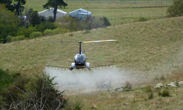
UAVOS has added the R22-UV unmanned helicopter to its agriculture unmanned aircraft portfolio for spraying for diseases, weed and pest control, and vegetative control.

The R22-UV is a manned Robinson-22 helicopter converted by UAVOS to an unmanned aircraft. (Photo: UAVOS)

The R22-UV is a manned Robinson-22 helicopter converted by UAVOS to an unmanned aircraft. (Photo: UAVOS)

The Agro-Drone R22-UV is equipped with a specially developed utility to deliver liquid chemicals — the spray system Simplex model 222.

The R22-UV drone is provided with a 100-liter tank for chemicals and can stay airborne for two hours. Weight of the system is 42 kilograms, boom span is 7 meters, and swath width is 14 to 16 meters.

UAVOS listed several advantages that could maximize the value of such a heavy UAV for farmers:

  • The R22-UV can be operated in the regions without airfields, under severe weather conditions and during night-time, in conditions with a high probability of risk for the pilot.
  • UAVs are excellent for operations in conditions of high humidity, where the use of ground equipment is impossible or difficult. Unlike heavy machinery, which cannot go into a field immediately after a heavy rain, UAV has no impact on the ground. Drone sprayers don’t touch the ground so there will be less soil compaction. This is when heavy machinery like tractors roll over the soil, pressing it down and damaging it. Farmers can fix this with plowing, but it can be harmful to the soil over a long period of time.
  • UAV implementation eliminates manual spraying with backpack sprayers, so workers don’t come into contact with hazardous chemicals.
  • UAVs also enable growers to spray their crops precisely and at will, which is critical for fighting herbicide-resistant weeds. Spraying is better. The rotor of an agricultural drone produces a huge downward rotation force, which promotes the pesticide droplets to penetrate the crop from top to bottom, which is conducive to the pesticide droplets evenly scattered in all parts of the plant, so that the spraying is accurate.
  • Unmanned aircraft can be used for spot spraying weeds with herbicides and are useful for spraying crops with pesticides. A spot-oriented approach based on preliminary analysis of digital images from robot cameras minimizes the cost of agrochemicals, reducing the chemical impact on soil, water, culture and, ultimately, on the consumer’s body, while achieving higher results of crop cultivation than with traditional approaches. The aircraft can be set on a predetermined GPS-defined route to fly over a field, dropping doses of pesticides, herbicides and fungicides as it flies.

“Precision agriculture is based on the use of valuable metrics to make farmers’ crop management efficient and optimized,” said Aliaksei Stratsilatau, CEO of UAVOS. “Validating-of-damage reports used to be on paper. So, unmanned aircraft help our customers to validate the veracity of reports so that we could come up with a comprehensive solution. Generally, agriculture is very complex and there are a lot of problems, but there are solutions available through the new technology.”

Publicerad den Lämna en kommentar

MicaSense offers Altum 3-in-1 sensor for ag drone mapping

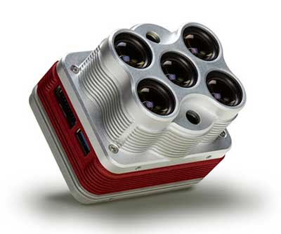
The Altum is a 3-in-1 sensor that combines thermal, high-resolution and multispectral imaging capabilities in one sensor. (Photo: MicaSense)

The Altum is a 3-in-1 sensor that combines thermal, high-resolution and multispectral imaging capabilities. (Photo: MicaSense)

The Altum sensor, offered by MicaSense, is designed for professional-grade agricultural drone mapping by enterprise and academic researchers. The Altum captures synchronized multispectral and thermal imagery, enabling aligned outputs for advanced analytics.

Altum’s multispectral imagers are the highest resolution integrated multispectral solution available for drones, allowing for detailed RGB outputs and advanced crop classifications.

Whereas before they had to fly multiple flights with multiple sensors, researchers, growers and service providers can now capture data for plant health, water stress mapping, phenotyping and more in one flight, with one sensor.

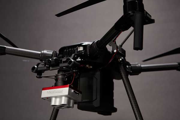
The Microsense RedEdge-MX sensor aboard DJI's M210 RTK drone. (Photo: MicaSense)

The Microsense RedEdge-MX sensor aboard DJI’s M210 RTK drone. (Photo: MicaSense)

“The Altum design resulted from experience developing advanced analytics and understanding needs for advanced research,” said Justin McAllister, CTO and co-founder of MicaSense. “We realized the market is limited by time and cost constraints of owning multiple sensors and flying multiple passes over the same field. The goal of Altum is to simplify the workflow, and with synchronized capture, to provide results that can be correlated and quantified more easily.”

Altum includes MicaSense’s standard five-band configuration of multispectral bands (red, green, blue, near-infrared and red-edge) and an integrated Lepton radiometric thermal longwave infrared sensor from FLIR Systems, providing temperature measurement for every pixel of the scene for additional crop data and optimization.

Expandable high-capacity USB 3.0 storage allows users to fly longer and cover more area without landing to swap storage. In addition, advancements in image capture rate enables faster flight speeds.

Users can process Altum data with industry standard software like Agisoft and Pix4Dmapper to generate an aligned, radiometrically calibrated six band (R, G, B, RE, NIR, T) geotiff, or access the raw data from Altum to process data themselves.

Included with Altum is DLS 2, the patent-pending next generation of the MicaSense Downwelling Light Sensor (DLS). DLS 2 allows for a more streamlined integration as it combines both the DLS and GPS into one product. In addition, through proprietary MicaSense technology, the DLS 2 will offer significantly better calibration for changing light conditions and better measurements over time.

Integrated solutions

Altum’s multiple interface options and open API gives users the ability to utilize Altum on a variety of platforms. In addition to the DJI SkyPort integration, Altum is integrated with drone offerings from the following companies (with more to come):

  • North America: Drone Nerds (U.S.), BirdsEyeView Aerobotics (U.S)., OmniView Tech (Canada), Sky Flight Robotics (U.S.), Blue Skies Drone Rental (U.S.)
  • Europe: 3D Target (IT), Globe Flight (DE), C-Astral (SI), Droneparts.de (DE), Ecobotix (DK), NaviGate (PL), Quantum Systems (DE)
  • Asia: Cybernetech (Japan), Shenzhen Qianhai Yaqi Technology (China)

DJI Payload SDK Program: Altum and RedEdge-MX for DJI M200 Series

Through DJI SkyPort, MicaSense is able to provide seamless integration of its specialized sensors with DJI’s powerful line of enterprise drones, resulting in the MicaSense Altum and RedEdge-MX solutions. This provides users a high-quality drone and sensor combination they can rely on to capture quality data every time – with virtually no set-up time.

The DJI SkyPort integration for Altum and RedEdge-MX features plug-and-play integration for Altum and RedEdge-MX right out of the box, including power and quick connect/disconnect, and enhanced light calibration with MicaSense DLS 2.

“Solutions like the MicaSense Altum and RedEdge-MX demonstrate the value of integrating specialized industrial payloads to DJI’s powerful drone platforms,” said Jan Gasparic, head of Enterprise Partnerships at DJI. “By collaborating with solution providers, we are expanding the benefits of drone technology to more and more industries. In the case of agriculture, a specialized suite of sensors and more advanced level of analytics can truly bring tangible value to business workflows and decision making today.”

The Altum and SkyPort enabled RedEdge-MX and Altum are available today through the MicaSense website.

Publicerad den Lämna en kommentar

NavCom releases Onyx software-upgradeable GNSS OEM board

NavCom Technology Inc., a wholly owned subsidiary of Deere & Company, has released the Onyx multi-frequency GNSS OEM board.

Offering integrated StarFire/RTK GNSS capabilities, Onyx features 255-channel tracking, including multi-constellation support for GPS, GLONASS, Beidou and Galileo. It also provides high-performance in GNSS receiver sensitivity and signal tracking as well as patented multipath mitigation, interference rejection and anti-jamming capabilities.

Photo: NavCom

Photo: NavCom

The new Onyx GNSS OEM board is a fully upgradeable GNSS receiver, allowing the receiver to upgrade from free DGPS signal sources such as WAAS to increased accuracy services with integrated industry leading features StarFire with Rapid Recovery or RTK with RTK Extend through software optioning alone.

The software-enabled features are sold in convenient software bundles, but can also be purchased individually, to suit changing application needs. Integrated StarFire is now simply activated via an over-the-air licensing system that sends a StarFire license via satellite directly to the StarFire-capable receiver from NavCom’s StarFire operations center.

StarFire, NavCom’s global satellite-based augmentation system (SBAS), provides real-time global 5-centimeter accuracy without a base station.

“The release of Onyx advances NavCom’s ability to grow products and services meeting the customer driven demands of uptime, accuracy, and feature rich capabilities,” said Steve Ault, NavCom’s GNSS product marketing manager. “NavCom continues to innovate the StarFire technology through the advanced capabilities inherent to Onyx which will be fully realized over the life of this new product.”

Publicerad den Lämna en kommentar

UAVs skyrocket to industry prominence

Photo: Quantum Systems/u-blox

Photo: Quantum Systems/u-blox

From growing crops to making movies, unmanned aerial vehicles (UAVs) are changing the way we work. UAVs — managed by unmanned aerial systems, or UAS — range from small indoor inspection units to giant Predator drones. They are streamlining how we manage mines and plants, deliver packages, and keep people safe. Read on to find out the latest in this skyrocketing market.

The unmanned aerial system (UAS) industry is in great shape! In the United States., the Federal Aviation Administration (FAA) appears to be helping commercial operations get off the ground, at least for those wishing to fly small unmanned aerial vehicles (UAVs).

Things are certainly hopping for unmanned aircraft in agriculture, mining and construction, facility inspection, newsgathering, movies and promotion. Package delivery is on the way, and, of course, defense is cooking with new innovations. Everywhere you look, a specialized drone or new application seems to appear that has good prospects for success.

One helpful aspect of today’s landscape for UAS operators in the U.S. is the FAA’s supportive approach to small UAS (sUAS) for commercial activities. After providing a regulatory framework with Part 107 rules, albeit with quite a few caveats that require a written waiver application, qualified drone operators are now able to fly their drones in many places — as long as they are below 400 feet, well away from airports, and nowhere near any restricted airspace.

Pilot qualification courses and proficiency testing are both readily available — at 676 commercial facilities across the U.S. according to the FAA website — and a successful online application process should result in a remote pilot’s certificate.

With a drone registered with the FAA, you can use the FAA’s B4UFLY mobile app to check if it’s safe to operate where you intend to. If it is, you can get approval in real time using the FAA’s Low Altitude Authorization and Notification Capability (LAANC) system. The FAA qualified LAANC to clear commercial drone operations, and the service is now provided by a large number of independent UAS service providers.

With the regulatory and approval path in place, it’s now possible for companies and individuals to earn a living with turn-key drone operations, providing services for many applications that have blossomed. There’s work to do beforehand, but it’s less arduous than for manned flight operations.

Let’s look at a few of the applications benefiting from the automation, enhancement and remote operations provided by UAVs as well as their on-board sensor suites and after-flight processing:

  • agriculture
  • mining and construction
  • facility inspection
  • newsgathering, movies and promotion
  • package delivery
  • defense
Crop health analysis: Precisionhawk’s software PrecisionAnalytics—Agriculture automatically generates georeferenced orthomosaics from data collected with drone sensors. (Map: PrecisionHawk)

Crop health analysis: Precisionhawk’s software PrecisionAnalytics—Agriculture automatically generates georeferenced orthomosaics from data collected with drone sensors. (Map: PrecisionHawk)

Agriculture

Agriculture has readily adopted UAVs to monitor, control and improve overall crop growth rates — a part of what is known as precision agriculture. Drones carrying optical, thermal and laser scanning payloads gather stacks of information about the condition and rates of growth in fields. The information is then fed into various analysis tools. A picture emerges over time that indicates the health of crops. This enables farmers to generate a formulas for the nutrient and weed-reduction chemicals used for spraying at various times of the year. It’s a customized “prescription” for each growing area.

Continuing UAV overflights during the growing cycle monitor the effects of growing conditions and the effectiveness of treatments, providing more feedback that lead to even further improvements.

Smaller tech-savvy farms might run their own programs, supported by local agrochemical suppliers that may provide analysis services or sell analysis tools.

However, there has been a real growth in the number of companies that supply an entire turn-key package — supplying and flying drones, gathering data, running analyses and providing written and graphic output to support the farming operation.

Unmanned aircraft are truly an integral part of this approach, which might only have been possible because of semi-autonomous UAS and the evolution of compact sensors: UAV-mounted infrared, high-precision optical and lidar.
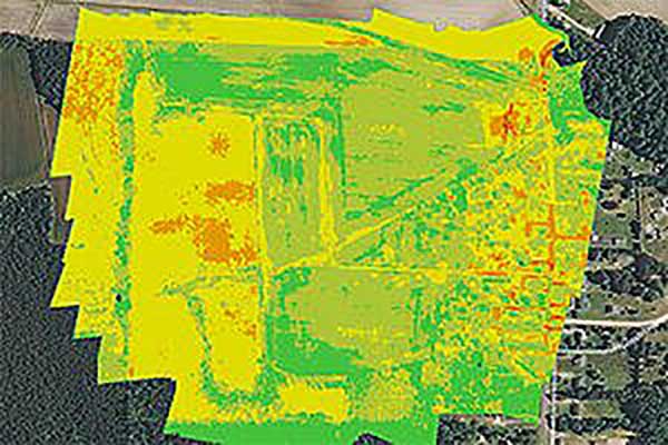
A sample prescription map. (Map: PrecisionHawk)

A sample prescription map. (Map: PrecisionHawk)

Mining and Construction

Any mine site is a busy — even chaotic — place to conduct a commercial business.

Drones provide a way for mining operations to:

  • quickly collect information to enable volume calculations;
  • provide relatively inexpensive site surveys; and
  • manage traffic and set up daily road layouts.

In effect, drones enable more rapid control of a complex and dynamic undertaking. Additionally, they improve safety. Ground surveyors no longer need to dodge huge operating machines and tumbling ore, or scramble around difficult terrain.

An autonomous drone can gather timely, georeferenced imagery that can be turned into a precise 3D model of the site. Site managers can have immediate access to details of the UAV survey. They can see the extent of existing deposits and know where to support further mineral exploration, receive estimates of stockpiles and tailing volumes, ensure that personnel and equipment are in the correct locations, and compare aerial video and photography day by day to check progress and for record-keeping. Drones can carry a wide variety of imaging and sensor packages including visual, infrared, hyperspectral, lidar, sonar and radar.

It’s also quicker. For instance, using the senseFly eBee fixed-wing drone, a full aerial survey of an 88-hectare site took four to five hours, with about half of that time spent placing control points. To achieve the same level of detail, terrestrial surveying would take a single surveyor two to three weeks.

Drones aid in management of complex, dynamic environments such as at this quarry in Ireland. Safety is also improved. This screenshot is from a fly-through animation generated using Pix4D Mapper software. (Screenshot: SenseFly)

Drones aid in management of complex, dynamic environments such as at this quarry in Ireland. Safety is also improved. This screenshot is from a fly-through animation generated using Pix4D Mapper software. (Screenshot: SenseFly)

Construction Operations. The construction sector uses the same drone data-capture techniques for site details, off-line analysis and results tabulation to manage operations of complex work sites. Compared to mining, change can be more intensive during a construction project, so drone surveys might be repeated more often.

Increasingly, drones are being used to inspect dangerous facilities. (Screenshot: General Electric)

Increasingly, drones are being used to inspect dangerous facilities. (Screenshot: General Electric)

Surveying and GIS. Using drones is an industry unto itself, with high-precision RTK GNSS in the air and on the ground, and specialized analysis tools for high-accuracy applications. The speed of data gathering is the principal benefit to an industry that continues to be essential in many sectors. Lower precision GIS for asset tracking and the like could become a subset of the applications and tools already discussed.

Facility inspection. Outdoor and indoor facility inspection is definitely benefiting from the automation that suitably equipped drones and customized analysis tools can bring to both regular and infrequent inspection tasks. The number of regular complex refinery inspections can be significantly reduced. Inspections will no longer interfere with production and will improve safety for inspection staff. For instance, flame stacks that burn off excess gases can be prone to failure, so regular inspection is essential. Using a drone for the task is clearly much safer than using personnel.

An offshore oil and gas construction platform vents gases to relieve pressure. Flame stacks such as these require regular inspection. (Photo: Oil and Gas Photographer/Shutterstock.com )

An offshore oil and gas construction platform vents gases to relieve pressure. Flame stacks such as these require regular inspection. (Photo: Oil and Gas Photographer/Shutterstock.com)

BVLOS for Pipelines and Rail

Automated pipeline and railway track inspection have both become possible as drones are used over much greater distances, thanks to beyond visual line of sight (BVLOS) operational approvals by the FAA.

For BVLOS, users first need a validated sense-and-avoid technology on the drone. Also required is proven radio telemetry with uninterrupted command-and-control of the vehicle during flight, and an independent ground-monitoring system that confirms how the drone maneuvers throughout the flight.

In the case of a BVLOS flight this summer along the Trans-Alaska oil pipeline, a Perimeter UAV manufactured by Skyfront flew about 4 miles, maintaining a constant above-ground altitude of 400 feet with multiple ascents and descents of 1,000 feet on 45-degree slopes. The long-range hybrid multicopter drone was equipped with Iris Automation’s computer vision collision-avoidance system and was monitored by
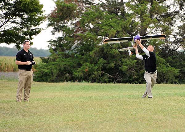
Launching a UAV for a BVLOS flight are (at left) Travis Balthazor, UAS flight operations manager, and Mike Kuni, UAS flight instructor/pilot, both of Kansas State University Polytechnic Campus. (Photo: KDOT, Division of Aviation)

Launching a UAV for a BVLOS flight are (at left) Travis Balthazor, UAS flight operations manager, and Mike Kuni, UAS flight instructor/pilot, both of Kansas State University Polytechnic Campus. (Photo: KDOT, Division of Aviation)

Echodyne radars along the pipeline path, providing airspace situational awareness.
Another BVLOS operation built on the achievements of the Trans-Alaska pipeline trial has been authorized to fly a nine-mile linear inspection of power lines in rural Kansas.

Once again, the Iris Automation system will provide collision avoidance, but this drone also has an independent automated avoidance capability. This gives the drone the self-contained ability to fly around obstacles, so no ground radar or visual tracking is required.

Relieving the requirement for radar tracking or visual observers makes many new operations affordable. Previously, FAA Part 107 BVLOS waivers have all required visual observers or ground-based radar tracking — requirements that are not only expensive, but also restrict where flights are possible.

BVLOS operations like these demonstrate the cost-effectiveness of the technical solution, making long-duration, long-distance inspection using drones feasible.
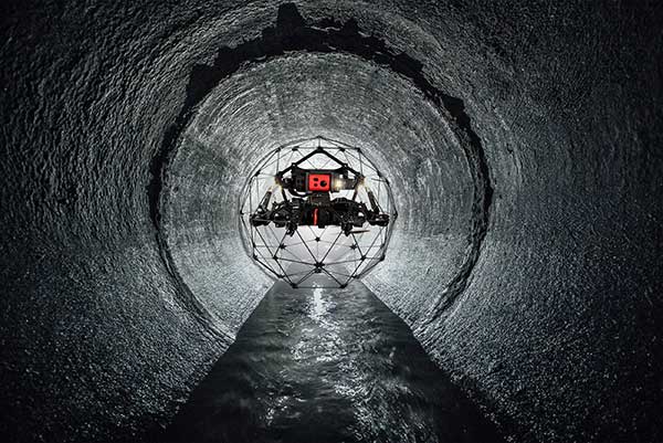
The Elios 2 indoor inspection UAV is encased in a collision-tolerant frame to protect both the drone and the environment it’s inspecting. (Photo: © Flyability)

The Elios 2 indoor inspection UAV is encased in a collision-tolerant frame to protect both the drone and the environment it’s inspecting. (Photo: © Flyability)

Indoor Inspection

Indoor inspection is becoming possible with specialized drones that circumvent the need to expose inspection staff to especially difficult facility environments, which in the past also required production shut-down to protect them. Thermal and visual sensors on swivel mounts enable protected inspection drones to fly into tight spaces — or even back out of tricky situations — and make visual records that may otherwise be virtually impossible.

Searching and recording inside containment vessels at the failed Fukushima nuclear facility may have been significantly advanced by using inspection drones.

Newsgathering, Movies and Promotion

All those panoramic, overhead, moving shots you see on the news, in movies and in ads used to be taken from a manned helicopter or fixed-wing aircraft. Now they are mostly taken by multi-copter drones with high-resolution cameras. This makes cinematography and newsgathering much more affordable, making these fields accessible by smaller operations. In the past, only large media groups could afford to rent a helicopter. And, of course, it’s much quicker to bring a UAV onto an incident site, operated by a crew on the ground.

You’ll need FAA approval to use a drone for commercial newsgathering purposes, or find a suitable qualified UAV and operator. After gaining FAA qualifications, news people are also taking on the job, buying and flying the equipment and managing the video-processing software themselves.

Others using drones for similar purposes are movie makers, producers of TV commercials and real estate agents, to name a few.

uavs have found their way onto movie sets, where cinematographers are taking advantage of improved cameras, better gimbals and sophisticated software. (Image: @DJIGlobalc)

uavs have found their way onto movie sets, where cinematographers are taking advantage of improved cameras, better gimbals and sophisticated software. (Image: @DJIGlobalc)

Delivery by Drone

The ultimate objective of many internet suppliers is to deliver goods that were just ordered within minutes of the order being placed. This is a pretty big objective. It requires a whole network of “fulfillment centers” in and around many cities, a massive purchasing and goods movement capability to keep these centers stocked, and a system that delivers to the end-customer. Currently, we mostly have manned panel trucks of various flavors handling that last step of the delivery process, with real people reading the notes we put on the porch about where to leave our package if we’re out.

Order and Receive. The next wave of delivery changes are expected to include drones carrying your package from the fulfillment center to your backyard. Amazon is looking for approval to begin trials with its larger 88-pound MK-27 Prime Air delivery drone, initially in sparsely populated areas. The MK-27 is equipped with intelligent sense-and-avoid capability, flying around any obstacles it encounters in flight and even during delivery.

UPS is also hoping to get to qualification of its own UAS delivery system by the end of this year, to the same standards that manned aircraft delivery systems are certificated.
Medical Deliveries. Many other trials are underway, especially involving medical deliveries and support. In Africa, trials are underway in Ghana, Malawi and Rwanda. UPS recently proposed a medical supplies delivery service using drones in North Carolina. Many companies that claim expertise in medical deliveries are operating drones.

A UPS drone carries medical supplies.(Photo: UPS)

A UPS drone carries medical supplies.(Photo: UPS)

Food on the Fly. Restaurant food delivery services have seen an upsurge in popularity. It seems likely that soon you’ll be able to order and receive lunch really quickly by drone food delivery services. Ground robot food deliveries at George Mason University are already a huge hit! Uber-Eats is experimenting with drone food deliveries, and 17 drone delivery routes have already been approved in an industrial park in Shanghai.

Meanwhile, Bell has flown its autonomous pod transport (APT) 70 near its base in Fort Worth, Texas, for the first time. The APT 70 can carry a 70-pound package load at over 100 mph, far faster and farther than existing drone delivery systems.

Bell is aiming for package delivery and critical medical transport for disaster relief for APT type drones. It is also participating in the NASA SOI program along with General Atomics’ SkyGuardian.

Bell’s APT 70 will be used as part of a NASA program in 2020. Bell aims to begin BVLOS tests in 2020, and begin commercial service soon after. The electric APT 70 can carry 70 pounds, cruise at 75 mph and cover 35 miles with a fully charged battery. (Image: Bell Helicopter Textron Inc.)

Bell’s APT 70 will be used as part of a NASA program in 2020. Bell aims to begin BVLOS tests in 2020, and begin commercial service soon after. The electric APT 70 can carry 70 pounds, cruise at 75 mph and cover 35 miles with a fully charged battery. (Image: Bell Helicopter Textron Inc.)

Drones are a new tool. The UAS industry will continue to change and adapt these products and this technology in as-yet-unthought-of ways. It’s an exciting time, and right now, there seems to be no end in sight.


For a look at drones in the defense industry, see Murfin’s article “Defense in front of UAV development,” published in September’s Professional OEM + UAV newsletter.

.

Publicerad den Lämna en kommentar

GSA stresses key role of GNSS at Intergeo workshop

GSA Market Development Innovation Officer Eduard Escalona speaks at the Intergeo Galileo workshop. (Photo: GSA)

GSA Market Development Innovation Officer Eduard Escalona speaks at the Intergeo Galileo workshop. (Photo: GSA)

News from the European GNSS Agency (GSA)

Galileo and EGNOS were the focus of attention at a special workshop at this year’s Intergeo in Stuttgart, which took place in September. Intergeo is the world’s leading conference and trade fair for geodesy, geo-information and land management.

Intergeo provided an opportunity to give an update on the status of the Galileo and EGNOS programs and to present user case studies at a special workshop focusing on the geomatics market.

In his presentation at the conference, Eduard Escalona, Market Development Innovation Officer at the European GNSS Agency (GSA), stressed the key role of GNSS.

“GNSS is a cornerstone in many areas: It is a fundamental element for cadastral surveying, in the construction sector, in mining, land surveying and mapping activities, for all geographic information systems (GIS), for infrastructure monitoring and for marine surveying. For all of you who are working in these and many other areas, Galileo is now helping to provide the GNSS services you need,” he said.

Dual-frequency boosts market

The European GNSS programs, Galileo and EGNOS, continue to move forward in terms of adoption by the professional market and among general users, thanks in no small part to the development of dual-frequency capability.

Traditionally, mobile, location-based applications have been powered by single-frequency GNSS receivers operating under stringent battery-power and footprint constraints. With a dual-frequency chipset, these devices now benefit from better accuracy, ionosphere error cancellation, improved tracking and better multipath resistance.

Galileo is leading the way in the area of dual-frequency signal delivery, now with more dual-frequency operational satellites in orbit than any other GNSS system. Market uptake of Galileo receivers has been impressive; in addition to the geomatics-related areas of particular interest to the Intergeo public, dual-frequency GNSS chipsets are also appearing in the automotive sector, where connected cars and autonomous vehicles present a clear and pressing need for accurate and reliable positioning information.

New services to come

“To date, more than one billion Galileo-enabled devices have been sold,” said Escalona, “but Galileo isn’t standing still, waiting. We are proposing new services to appear in the coming years.”

These include the much-anticipated High-Accuracy Service (HAS) and a new Authentication Service. “The HAS will be a free, globally available service providing an accuracy of 20 cm, with PPP [Precise Point Positioning] corrections,” Escalona said.

Meanwhile, the Authentication Service (OS-NMA) will provide protection against jamming, spoofing and meaconing on the E1B signal and a separate Signal Authentication Service (SAS) will provide an even higher level of protection on the E6 signal.

“EGNOS is currently working with GPS, but of course we are looking forward to augmenting Galileo in the near future,” said Sergio Cabrera Bona, EGNOS Service Adoption Tools Engineer at the European Satellite Services Provider, whose core activities comprise EGNOS operations and service provision.

“GNSS is critical in all of these fields, whether it is mapping and GIS, farming, forestry, thermal pictures, management of natural terrains,” Cabrera said. He listed other areas, including management and inspection of utilities, power networks, water supply, telecoms, drones, inventory, surveying, field campaigns and determination of perimeters in agriculture as areas where GNSS plays a key role.

“It is not possible to mention all of the activities where you need reliable positioning. What you have to know is that with EGNOS augmentations you already have a horizontal accuracy below one metre and a vertical accuracy below two metres, so this is a very good accuracy,” he said.

There is much more that could potentially be done right now, Cabrera explained. “Most of the professional equipment is already EGNOS-enabled, but in practice users do not always configure their equipment correctly to exploit this capability. EGNOS adoption and support is going ahead full speed, but in the GNSS device market, many users still do not know they can use EGNOS. So the education process remains an ongoing effort,” he said.

Cabrera explained that the EGNOS user support website can be an important part of this educational drive on the top of the help desk. “We have very interesting tools and resources available online. For example, we will have a new EGNOS usability map available very soon on the website. With this tool you will be able to easily see the current availability of EGNOS signals in your location, which will be very useful especially in urban environments, for example. We also have many user support services and there is a new mobile app coming, so please visit our website and take advantage of EGNOS. It is there for you.”

Introducing the GSC

Galileo services improvement expert Pedro Gómez Martínez informed participants about the European GNSS Service Centre (GSC), defining both the concept of operations as well as the procedures necessary to provide the services that the GSA offers to Galileo users.

“The European GNSS Service Centre is the single interface between the infrastructure and users of the Galileo open services, commercial service and search and rescue service (SAR),” said Gómez. “So the GSC is a center that provides experts, know-how, evaluation of capability, distribution of information and support for the provision of value-added services provided by the Galileo system.”

The GSC website is a core resource for Galileo users, Gómez said, reporting real-time system status and incident notifications, with a bank of key documents and a full-time help desk. “It is very important for us that this is a two-way interactive service that includes your feedback. We need you to report any incidents that you might experience related to the product, service and data provision. We are very interested in user satisfaction, and we want to know how you respond to improvements. And of course, in general, we are here to promote GNSS in all its forms, in all areas, for all users.”

The GSC launched a new version of its website in the run-up to the InterGEO event. “More than ever we are making it easier for you to engage in dialogue with us and to provide your feedback. This is very important to us with new services coming up in the future,” Gomez said.

Research fundamentals

“One of the very important responsibilities of the GSA is the management of a number of EGNSS research and development programmes,” said Eduard Escalona. “We have Horizon 2020, the European Union’s research Framework Programme. There we have a final call for proposals coming up in November, with a deadline in March 2020. The GSA also is overseeing the Fundamental Elements programme, which is funding research specifically targeted at developing Galileo-enabled chipsets, receivers and related technologies.”

To illustrate Escalona’s point, the presentations featured EU-funded GNSS-related research projects leveraging the accuracy and integrity offered by Galileo. Pere Molina of Geonumerics presented the MapKite project. Funded under Horizon 2020 and now completed, MapKite integrates an unmanned aerial system (UAS) and a mobile mapping aystem (MMS) for simultaneous capture of geo-data from the air and from the ground. Molina showed data from a successful corridor mapping exercise run using the MapKite system.

Publicerad den Lämna en kommentar

Shark Bait operation shows value of Galileo search and rescue

News from the European GNSS Service

The huge value of the Galileo Search and Rescue (SAR) service was underlined in a live demonstration off the coast of Belgium on Thursday, Sept. 26.

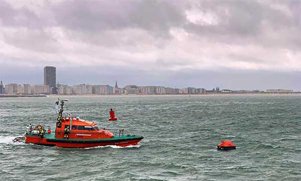
Operation Shark Bait showed how this vital service can quickly trigger a rescue operation and save lives at sea. Despite a grey day and choppy sea conditions, an emergency rescue was initiated in just over three and a half minutes after intrepid “volunteer victim,” Australian broadcaster and explorer Tara Foster, operated her Galileo-enabled SAR beacon from a small life raft buffeted by the waves just offshore from the port of Ostend.

Operation Shark Bait was a specially designed demonstration of the capabilities of the Galileo SAR service that took place around the new state-of-the-art Belgian Maritime Rescue and Coordination Centre (MRCC) in Ostend with an invited audience of VIPs and media. The whole operation was streamed live over YouTube and the Europe By Satellite (EBS) TV service.

The Shark Bait test took just over three and a half minutes to locate the PLB developed under a GSA Horizon 2020 project. (Photo: GSA)

The Shark Bait test took just over three and a half minutes to locate the PLB developed under a GSA Horizon 2020 project. (Photo: GSA)

The scenario was simple. Tara was left alone at sea in a small life raft, but with a 406-MHz Cospas-Sarsat personal locator beacon (PLB). On activating the beacon, the stopwatch started. The time to receive the distress signal, compute her position and alert the relevant rescue authorities was recorded. The Belgian fast rescue boat ORKA R6 then dashed out to sea to pick her up.

Subsequently, a NH90 Cayman SAR helicopter from the Belgian 40th squadron was also scrambled to help transfer “injured” Tara to hospital.

Shark Bait was a great success with just 3 minutes 32 seconds elapsing from Tara activating her Galileo-enabled personal locator beacon (PLB) to the moment commanders at MRCC could dispatch the ORKA to her location.

The location, with an initial accuracy of 100 metres, is provided by the Galileo receiver inside the PLB to the Galileo satellites in view. The Galileo satellites then forward this information to the Cospas-Sarsat infrastructure, where the position is validated.

“The PLB used was developed under one of our Horizon 2020 projects and is the first Galileo-enabled beacon on the market,” said Fiammetta Diani, head of market development at the GSA.

Time saver, life saver

The day started at the MRCC in Ostend with a visit to the operations centre, an inspection of the ORKA Fast Rescue Boat and a chance to talk to Tara Foster before she was “castaway” on the waves.

Dries Boodts, deputy nautical director at MRCC, described the role of the center, which has a single focus on safety at sea. “The globe is divided into Search and Rescue Regions (SRRs),” Boodts said. “The MRCC oversees the Belgian maritime region that extends up to 47 miles off the Belgian coast.”

The region includes major shipping lanes and two large offshore wind energy parks. The MRCC deals with around 450 incidents each year involving a range of craft and issues from collisions at sea to war munitions recovery. It can call on an assortment of assets including its own rescue craft, police and navy vessels and the Belgian air force and the MRCC collaborates extensively with authorities in neighbouring countries.

Galileo is Europe’s contribution to upgrading Cospas-Sarsat, the global satellite-based search-and-rescue system. Since its introduction in 1981, Cospas-Sarsat is estimated to have saved 45,000 lives.

The current MEOSAR (Mid-Earth Orbit Search and Rescue) upgrade is based on the EU’s Galileo satellite constellation that carries a dedicated Cospas-Sarsat payload for the 406-MHz distress beacons that give users free access to global system.

The addition of Galileo (and other GNSS satellites) to the system has already enabled a dramatic increase in performance in terms of better accuracy to locate activated distress beacons and vastly improved global coverage.

“With the Galileo system, all parts of the world will be covered at least every 10 minutes — previously this was up to four hours — and guaranteed location accuracy is reduced from 10 to 2 kilometers,” explained Jolanda van Eijndthoven from the European Commission.

As well as the 23 SAR payloads currently provided by Galileo, with more to come, the EU also provides ground infrastructure including MEO Local User Terminals (LUTs) to pick up the signals relayed from the satellites. These LUTs are not just in Europe, and a fourth facility is o be opened soon on La Reunion island to improve coverage across the Indian Ocean.

Return link reassurance

From the end of the year the Galileo system will also provide a Return Link Service (RLS) that will be able to send an acknowledgement to the victim that their distress signal has been received and help is on its way. This new ability to provide reassurance should deliver a valuable psychological lift to victims and further boost survival rates.

“The PLBs developed under our Horizon 2020 projects will be the first ones on the market to have the RLS capability,” said Fiammetta Diani.

Back on dry land, Tara confessed that the simulation had felt very real to her. “The scariest part was the transfer to the helicopter from the rescue boat,” she said. “The winch was like a lift without a floor and very fast! Stepping from the flimsy life raft to the ORKA was also not easy – those waves were high!”

“The operation went just like clockwork,” concluded Paul Flament Head of the Galileo and EGNOS unit at the European Commission’s DG GROW.

Publicerad den Lämna en kommentar

GSA releases 2019 GNSS Market Report

Image: GSA

Image: GSA

The new GSA GNSS Market Report is now available for download. The report provides a comprehensive overview of the GNSS market and the global industry, as well as a focus on EGNSS differentiators and synergies with Copernicus, according to the publisher, the European GNSS Agency (GSA).

Areas covered include:

  • A general overview of the GNSS market and a global industry overview.
    Analysis of macro-trends affecting GNSS, including climate change and the circular economy, big data, artificial intelligence, the silver economy, cyber security and the sharing economy.
  • A review of the main GNSS market segments in detail, including trends and developments, forecasts for future shipments, revenues and the GNSS installed base, and a look into GNSS user requirements.

GNSS in Space. This year, the report features the “Editor’s Special: GNSS for NewSpace,” a section that introduces GNSS receivers in satellites and their relation to the evolving space sector.

GNSS market monitoring is a key activity of the GSA. Market monitoring supports GNSS stakeholders in their planning and decision-making, and offers a clear tool to understand GNSS trends and evolutions.

Since its launch in 2010, the GSA GNSS Market Report has become the go-to-source for information on the dynamic, global GNSS market segments and applications.