Publicerad den Lämna en kommentar

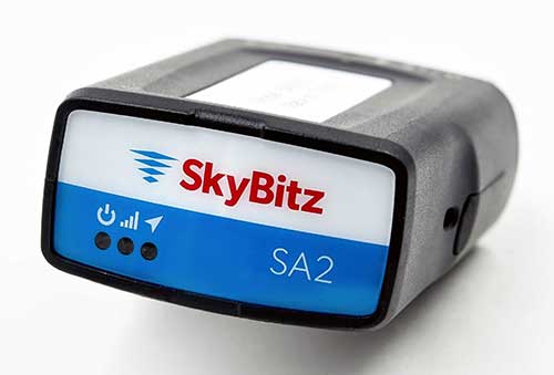
SkyBitz GPS tracker targeted at light- to medium-duty trucks

SA2012 offers customers configurable GPS tracking device on the latest 4G network

Photo: SkyBitz

Photo: SkyBitz

SkyBitz has launched the SA2012, equipped with the latest 4G LTE with 3G fallback, positioned for the light- to medium-duty vehicle tracking market.

With the option to purchase a range of price packages with configurable feature sets, the SA2012 is designed for customers looking for a scalable vehicle telematics solution they can use to increase profit margins and satisfy customer demand.

The hardware can be installed using the Ops Center mobile device, either directly plugging it into the vehicle diagnostic port or covertly installing it behind the dashboard, depending on customer preference.

Once installed, the device feeds into the SkyBitz Ops Center platform, where users can manage the new device alongside all others via a single interface. Customers will have coverage across North America, including Mexico and Canada.

The basic package includes GPS location data and estimated odometer and engine hours. With several options leading up to the Pro package, SkyBitz offers a variety of location, engine, and safety data that can be selected based on the customers’ operational goals and budget.

Customers can configure their solution with minimal training, adding features such as advanced alarms and notification schedules and over-the-air upgrades when future features are released.

“SkyBitz strives to bring the latest technology to market that meets industry demand but also exceeds our customers’ expectations. This is one more device added to the SkyBitz product line that is now delivered on the latest network, and integrated into the SkyBitz Ops Center platform so customers can easily see vehicle and asset data on one dashboard,” said Debbie Sackman, senior product manager with SkyBitz. “This device targets small and medium businesses and offers a flexible package choice where customers can add additional features with OTA upgrades as their business grows.”

Publicerad den Lämna en kommentar

ION seeks abstracts for 2020 JNC, deadline Feb. 3

ION JNC logoThe Institute of Navigation is asking for abstracts for the 2020 ION Joint Navigation Conference. JNC 2020 will be held June 1-3 at the Northern Kentucky Convention Center in Covington, Kentucky/Cincinnati, Ohio.

The US ONLY CLASSIFIED sessions will be held June 4 at the Air Force Institute of Technology in Dayton, Ohio.

Abstracts are due Feb. 3, 2020.

JNC is the largest U.S. military Positioning, Navigation and Timing (PNT) technologies conference of the year with joint service and government participation. The JNC theme is Enhancing Dominance and Resilience for Warfighting and Homeland Security PNT.

The event will focus on technical advances in PNT with emphasis on joint development, test and support of affordable PNT systems, logistics and integration with more than 150 operational presentations.

Abstracts will be accepted through Feb. 3, 2020. For more information about JNC 2020, visit ion.org/jnc.

Exhibit Opportunities
JNC features a technical exhibit and showcase of guidance, navigation and control technology products and services. The exhibit hall (June 2-3) will be open to all conference participants, exhibiting organizations, their employees and related organizations.

All materials displayed in the exhibit hall shall be publicly releasable (Distribution A). For more information on exhibiting, visitwww.ion.org/jnc.

Attendance Restricted Technical Sessions
Conference attendance for both FOUO US ONLY (June 1-3) and US ONLY Secret Clearance (June 4) sessions will be screened by the Joint Navigation Warfare Center and will be restricted to US ONLY. Advance visit requests and approvals are required for all technical participants.

Quick Links for ION JNC 2020

Publicerad den Lämna en kommentar

Kongsberg Geospatial and AiRXOS partner on UTM airspace management for critical infrastructure

New solution integrates the real-time Kongsberg IRIS UAS airspace management picture into the AiRXOS’ Air Mobility Platform to provide integrated unmanned traffic management services around critical infrastructure

AiRXOS, part of GE Aviation, has fully integrated the real-time airspace picture from the Kongsberg Geospatial IRIS airspace management application into its own Air Mobility Platform for unmanned traffic management.

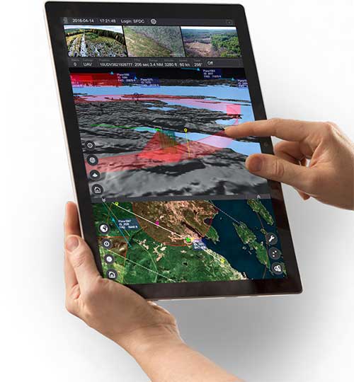
IRIS UAS is a spatial awareness system that allows UAS pilots to operate safely beyond Visual Line-of-Sight (BVLOS). The system is shown here running on a Windows Surface Pro tablet. (Photo: Kongsberg Geospatial)

IRIS UAS is a spatial awareness system that allows UAS pilots to operate safely beyond visual line of sight (BVLOS). The system is shown here running on a Windows Surface Pro tablet. (Photo: Kongsberg Geospatial)

IRIS UAS fuses multiple disparate, real-time sensor feeds to create a highly accurate airspace picture around critical infrastructure locations such as airports.

This provides real-time calculation of aircraft separation, airspace monitoring alerts and communications line-of-sight prediction to enable detect and avoid for safe beyond visual line of sight (BVLOS) operations.

The real-time local airspace picture is then integrated into the cloud-based AiRXOS’ Air Mobility Platform, a dynamic, cloud-based foundation, purpose-built for advanced operations and the evolving future of transportation.

The Air Mobility Platform manages the volume, density, and variety of unmanned traffic management (UTM) data, and provides enterprises with a single platform to connect and manage operations, applications and devices.

Through this collaboration, the companies will provide UTM customers with a fully integrated view of airspace for real-time airspace insights, and greater scalability and repeatability of advanced operations.

“Situational awareness of the airspace across applications, unmanned aerial system (UAS) advanced operations, conformance monitoring, compliance, and pilots is critical to a UTM environment — allowing enterprises to be more responsive and efficient,” said Ken Stewart, CEO, AiRXOS. “Our partnership combines Kongsberg Geospatial’s expertise in airspace management with AiRXOS’ dynamic platform, applications, and services, providing customers with the opportunity to truly scale critical infrastructure advanced UAS operations like BVLOS and multi-vehicle, helping to lower risk and increase savings.”

“We’re very pleased to be working with an unmanned traffic management innovator like AiRXOS,” said Ranald McGillis, president of Kongsberg Geospatial. “Their ability to create a comprehensive surveillance view of operations and then to scale it for a nationwide use provides an excellent and very unique use case for our technology.”

Publicerad den Lämna en kommentar

VW Golf launches in Europe with NXP’s secure V2X technology

Volkswagen and NXP to Deliver Safety to European Roads with Rollout of Communicating Car Technology

NXP Semiconductors N.V., a provider of automotive semiconductors, has rolled out its RoadLINK V2X (vehicle to everything) communication solution in the new Volkswagen Golf.

The recently released eighth-generation Golf is the first volume European car model equipped with V2X, offering a major boost to the deployment of the technology on European roads and beyond.

Life-saving tech. The technology can prevent accidents by having cars communicate with each other, independent of car brands and without the support of cellular infrastructure.

“Road safety forms the core of VW’s commitment to its customers. As a high-volume manufacturer we aim to be a pioneer in this space,” said Johannes Neft, head of Vehicle Body Development for the Volkswagen brand. “The introduction of V2X, together with traffic infrastructure providers and other vehicle manufacturers, is a major milestone in this direction. Volkswagen includes this technology, which doesn’t involve any user fees, as a standard feature to accelerate V2X penetration in Europe.”

“Volkswagen has taken a bold step to seize the road safety initiative through the implementation of V2X,” said Torsten Lehman, senior vice president and general manager of Driver Assistance and Infotainment at NXP. “After proving our technology in more than one million test days globally, we are pleased that our RoadLINK technology, developed in cooperation with Cohda Wireless, was chosen to enable new levels of safety in Europe’s most popular car model, the new Golf.”

NXP and Volkswagen have closely collaborated for high reliability and performance, as well as for standardization of V2X communication that addresses cybersecurity and privacy protection.

V2X in Europe. Wi-Fi-based V2X is a mature technology that has been tested for more than 10 years. Today, 1,000 kilometers (km) of European roads are equipped with V2X technology based on Wi-Fi with 5,000 km planned through the end of 2019.

Its research and development, testing and standardization has occurred within a strong global ecosystem of suppliers and car manufacturers to ensure reliability in diverse road and traffic conditions.

Wi-Fi therefore forms the basis of the European standard that has been chosen for vehicle-to-vehicle and vehicle-to-infrastructure communication, according to NXP. An additional benefit is its availability independent of paid cellular services. Other developing cellular-based technologies can be added complementary to Wi-Fi-based V2X.

Migration to autonomous. V2X communication is set to become a critical part of advanced driving assistance systems (ADAS) and the migration to autonomous cars that communicate with each other and with traffic infrastructure.

The benefit of Wi-Fi-based V2X is its robust, low latency, real-time communication regardless of any car brands.

  • It enables awareness and communication between cars, road infrastructure like traffic lights or street signs, and other road users such as cyclists and pedestrians.
  • It is a technology that is collaborative, allowing it to “tap into” surrounding sensor data from mutually equipped cars to warn of hazards and prevent accidents.
  • V2X is a technology that complements other ADAS sensing technologies such as radar, lidar and cameras.
  • It helps vehicles to “see” more than a mile ahead and around corners to provide early warning of obstacles, hazards and road conditions.
  • It has the ability to “see” through objects, delivering more information than that obtained through line of sight only.
  • Its sensing capabilities are unaffected by poor weather conditions.
Photo: Volkswagen

Photo: Volkswagen

Publicerad den Lämna en kommentar

Navigating testing options: Simulator innovators map out solutions and trends

This tongue-in-cheek photo, courtesy of Racelogic, underlines how simulators help GNSS engineers “road test” multiple positioning products in multiple scenarios. (Photo: Racelogic)

This tongue-in-cheek photo, courtesy of Racelogic, underlines how simulators help GNSS engineers “road test” multiple positioning products in multiple scenarios. (Photo: Racelogic)

The number of GNSS signals, the frequency and sophistication of intentional and unintentional threats to those signals, and the need for integration between GNSS and other positioning, navigation and timing (PNT) sources — especially for indoor and autonomous navigation — are continuing to increase, as is the number of new applications for GNSS. In response, manufacturers of GNSS simulators are creating new and improved models able to simulate all these new signals and scenarios.

Additionally, as GNSS chipsets continue to be further commoditized, simulator manufacturers must address the needs of new entrants into the GNSS receiver market that have lower accuracy requirements and require less technical expertise and, therefore, require units that are smaller and cheaper and have simpler interfaces.

No single manufacturer can address the full spectrum of challenges that these trends present. So, while their products overlap in capabilities and SWaP-C (size, weight, power and cost), each one has chosen its market niche and preferred mix of features.
Even on the deceptively simple question of definition (“What is a GNSS simulator?”), the seven manufacturers featured here give different answers, covering the following capabilities:

  • Simulating GNSS signals as well as inertial navigation data.
  • Enabling users to test hardware, software and new solutions in the lab before deployment.
  • Enabling users to test systems under pristine or extreme conditions, including error conditions.
  • Enabling users to test systems during rare, transitional and prohibited events.
  • Helping to retrofit existing equipment to new and emerging standards.

Innovations being introduced or developed include:

  • an anechoic simulator to test continuous radiation pattern antennas (CRPAs).
  • simulation of a full M-code modernized signal.
  • software-defined simulators.
  • increased automation of repetitive tasks.
  • the capability to record and replay real-world signals.
  • the capability to record and synchronize data on the conditions faced by a test vehicle.

While the universe of GNSS satellites and receivers continues to grow and evolve, the universe of GNSS simulators is keeping pace — or even a step ahead.


Click on the company to be directed to that section.


CAST Navigation

John F. Clark, Vice President, Engineering. (Photo: CAST Navigation)

John F. Clark, Vice President, Engineering. (Photo: CAST Navigation)

In the lab, simulators allow users to “drive” a piece of equipment through 3D space, performing flight testing or checking equipment integration. Simulators also validate operational flight programs (OFPs) for pilots before they are fielded, to ensure that the software is working correctly.

Innovation. CAST’s latest simulator is the CAST 5000 wavefront generator. It allows users to drive GNSS and interference signals that represent a continuous radiation pattern antenna (CRPA), which consists of multiple, smaller antennas all combined into one unit. In real life, each one of those antenna elements is in a different location; therefore, when they receive signals from a jammer or any of the GNSS satellites, each one will see that signal in a slightly different phase from the other elements. “Our simulator allows us to present signals to these antennas that model the same type of phase differentiation that you see in real life,” Clark said.
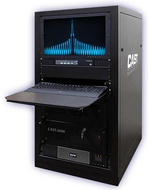
Photo: CAST Navigation

Photo: CAST Navigation

Coming Next. CAST Navigation is constantly improving its software based on user feedback. “We are in the process of enhancing our user interface to make it much more powerful but also much simpler to use,” Clark said. Hardware is also being improved, with implementation of the latest available GNSS always on the list.

Looking Ahead to 2022. Jamming and spoofing are becoming more prevalent, not just for the military but also for consumers. Consumers are starting to encounter more instances of jamming, denying their phone the ability to track a GPS satellite or transmitting incorrect GPS data so the solution that their device gives them is not correct. “Our focus is on products and capabilities that help our customers simulate those types of environments and mitigate those kinds of reactions,” Clark said.


Jackson Labs Technologies Inc.

Said Jackson, President and CTO. (Photo: Jackson Labs)

Said Jackson, President and CTO. (Photo: Jackson Labs)

Jackson Labs’ simulators take a position, navigation or timing signal, re-encode it into an RF signal through a GPS simulation procedure, and output a real-time RF signal that encodes the position, navigation and timing (PNT) information, within milliseconds, into an RF signal that can be fed into existing equipment. “We came up with a general-purpose simulator that is basically a no-frills, low-cost, highly accurate, highly stable, highly reliable, extremely small GPS-only simulator,” explained Jackson. “We only provide GPS L1 simulation, to keep the cost of the product down, because GPS L1 C/A code is the only code required to generate an accurate and assured PNT fix, and because we are looking at simulating to embedded systems, where you only need an L1 C/A code simulator.”
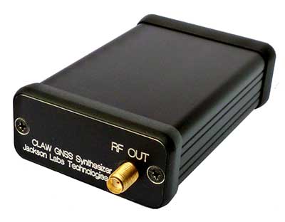
Photo: Jackson Labs

Photo: Jackson Labs

Coming Next. Jackson Labs’ simulators don’t require an external computer for data processing or control. That makes it possible for companies like Toyota to plug the unit into a car on the assembly line, and generate RF output that is fed into their GPS-based navigation systems to pass final quality-assurance checks on the production line. Jackson Labs expects to further reduce SWaP-C (size, weight, power and cost) requirements and potentially add other signals. “We are also looking to potentially combine our simulators with other product lines that we have, such as our comprehensive atomic clock product line,” Jackson said.

Looking Ahead to 2022. Jackson predicts that the sector will split into two paths: an industrial sector with units for manufacturing and deployment, and companies that introduce emerging GNSS systems at much lower price points, smaller SWaP, and with more modular deployment. Inertial navigation systems (INS) are critical for autonomous driving and assured capabilities during spoofing and jamming events, Jackson said. “It is not possible today to very easily simulate INS units.There is a market for innovation in terms of integrating what the military calls ‘assured PNT,’ which includes things like dual navigation.”


Orolia

Stéphane Hamel, Director, Testing and Simulation. (Photo: Orolia)

Stéphane Hamel, Director, Testing and Simulation. (Photo: Orolia)

According to Orolia’s Hamel, a simulator’s purpose is two-fold: first, it must reproduce threats and second, it must prove the solution is working.

Innovation. When Skydel Solutions joined Orolia in March, it brought a professional software-defined simulator that makes possible fast prototyping and development cycles. It integrates advanced interference simulation and can simulate hundreds of threats simultaneously. “When you want to do a repetitive step, automation is the key,” Hamel said. “Our simulator can teach you how to automate, just by clicking on a button and generating source code.” In 2018, Skydel introduced an anechoic simulator to test Controlled reception pattern antennas (CRPAs). Also new is a waveform simulator, so CRPA units can be tested in a conducted (rather than radiated) way.

Image: Orolia

Image: Orolia

Coming Next. In the next three years, Orolia is looking at adding Galileo PRS, GPS M-code, or the next-generation signal. “Being software-defined means that we are very flexible and we can allow our partners to develop their own plug-ins,” Hamel said. “They can build custom signals, restricted or modernized signals. Our simulator will take care of the dynamics of the signal and our partners can focus on the characteristics of the signal, or the things that are secret, classified, or if they simply want to protect their IP.”

Looking Ahead to 2022. Resilience to serious spoofing and jamming threats is high on Orolia’s list, as well as ensuring secure or valid positioning, navigation and timing (PNT) in GPS-denied environments. Alternative signals, sensors and increased complexity require a simulator to address all of these. Companies that develop complex proprietary hardware platforms will be challenged to keep up with the increasing complexity. and a software-defined approach will be an advantage.


Racelogic

Julian Thomas, Managing Director. (Photo: Racelogic)

Julian Thomas, Managing Director. (Photo: Racelogic)

Racelogic’s first LabSat was a recorder with player — the signals were recorded outside, and then replayed in the lab. Racelogic’s simulators now also provide simulation of the signals using software to generate the signals as though they are being sent by the satellites.

Innovation. In 2018, Racelogic introduced the LabSat wideband, which uses the company’s SatGen software. It records at 56 MHz and up to 6 bits of resolution and streams the data to an internal SSD hard drive. It can also replay real-world simulations or ones generated with SatGen. For the automotive world, it records and replays signals such as CAN, RS232, RS485, IMU and other data channels, synchronizing them at the same time. VBOX allows users to record and replay video with the perfectly synchronized recording made on the LabSat. “You see exactly the kinds of conditions of the test vehicle or person who has been subjected to the test,” Thomas said.

Photo: Spirent

Photo: Spirent

Coming Next. Racelogic is providing wider bandwidth, greater bit depth, and multiple channels in a small battery-powered device that records even more signals, including lidar, EtherCAT (an automotive Ethernet format) and CAN-FD (a faster version of the CAN format). It will be able to synchronize with multiple video cameras instead of just one in high resolution. “It is basically the same as what we are selling, but on steroids, and at a very similar price point,” Thomas said.

Looking Ahead to 2022. With multi-GNSS going mainstream, both chip manufacturers and simulator manufacturers will be challenged by the cost of test equipment. Chip makers need to be able to test the new signals on their production lines, while simulator makers will need to provide devices at a price point and ease of use for customers with less stringent or slightly less technical requirements. “They need a simpler interface and a smaller, cheaper unit,” Thomas said.


Rohde & Schwarz

Markus Irsigler, Product Manager, Signal Generators. (Photo: Rohde & Schwarz)

Markus Irsigler, Product Manager, Signal Generators. (Photo: Rohde & Schwarz)

An increasing number of GNSS applications depend on multi-frequency GNSS.

Innovation. In response, Rohde & Schwarz added multi-frequency test capabilities to its entry-level and mid-range test solutions. “We have launched a new GNSS simulator based on the new mid-range vector signal generator R&S SMBV100B,” Irsigler said. A simple and flexible option concept allows users to turn the instrument into a full-featured and powerful GNSS signal source. It addresses a wide range of test applications, from single- and multi-frequency production testing to multi-frequency receiver characterization. The instrument can be equipped with an internal noise generator that allows users to simulate GNSS plus noise or CW interference without using additional external hardware.
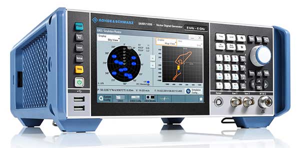
Photo: Rohde & Schwarz

Photo: Rohde & Schwarz

Coming Next. GNSS test solutions from R&S are based on general-purpose vector signal generators. With this approach, GNSS and other signals can be generated at the same time in the same instrument allowing coexistence and interference testing without additional external signal sources. As this results in test solutions that are compact and very flexible to use, R&S will continue to use this approach for upcoming product upgrades and enhancements as well as for its next generation of GNSS test solutions. The company’s upcoming activities will mainly focus on the high-end segment, where the R&S SMW200A with up to 4 RF outputs and up to 144 channels addresses multi-antenna and multi-vehicle GNSS test applications.

Looking Ahead to 2022. With the safety demands of autonomous driving or aircraft landing procedures, multi-frequency testing will become standard. Because such applications must be sufficiently robust against spoofing and jamming threats, there will be an increasing need to test navigation systems against such influences. “Simulating GNSS alone is not enough,” Irsigler said. “Test solutions for autonomous driving will require several other techniques and signals to be applied or simulated, such as RTK/PPP or outputs from other vehicle sensors to perform sensor fusion.”


Spirent Federal Systems

Roger Hart, Director of Engineering. (Photo: Spirent)

Roger Hart, Director of Engineering. (Photo: Spirent)

Spirent’s simulators test with “real-world” signals as well as allowing tests under pristine conditions or under extreme conditions that may never occur in the real world, including error conditions.

Innovation. In December 2018, Spirent released the SimMNSA, which provides a full M-code modernized signal solution. Until now, the GPS Directorate limited M-code simulation to either pseudo-M-code, which provides the same spread-spectrum but uses a commercial encryption standard, or a system of playing back a canned set of M-code limited to certain satellites and dates and times. With the policy change, Spirent can now implement M-code based on the modernized Navstar security algorithm (MNSA), and now offers both an M-code solution with the SimMNSA and a full Y-code with the SimSAAS.

Jeff Martin, Director of Sales. (Photo: Spirent)

Jeff Martin, Director of Sales. (Photo: Spirent)

Coming Next. Spirent plans to provide customers an increased channel count to help test multi-constellation, multi-frequency receivers against multipath, jamming and spoofing. “We are in a period of intense development in terms of AVs, UAVs, and so forth, which don’t use GNSS exclusively,” Hart said, explaining that Spirent is working on testing of GNSS/sensor-fusion platforms.

Looking Ahead to 2022. “As new interface specifications are released, we are proactive in developing new signals,” Hart said. Spirent also is supporting efforts to achieve assured PNT solutions. It is investigating interference-mitigation techniques such as algorithms, directional antennas, and other anti-jam technologies. Signal authentication is another need. “As the systems are becoming more integrated and networked, we are conscious of cyber-security threats and are looking in that area,” Hart said.

Photo: Spirent

Photo: Spirent


Syntony GNSS

Cyrille Gernot, GNSS Receiver Development and Product Manager. (Photo: Syntony GNSS)

Cyrille Gernot, GNSS Receiver Development and Product Manager. (Photo: Syntony GNSS)

GNSS receiver manufacturers use simulators to ensure that their products are robust in challenging situations that can’t be clearly assessed using real-world data. “That’s where the GNSS simulator comes into play,” Gernot said, “by offering controlled and repeatable scenarios.”

Innovation. Syntony’s new pseudo-random-noise code (PRN code) server allows the GNSS simulator user to dynamically send the pseudo-random sequence modulating a carrier. It is especially useful for testing encrypted signals such as the GPS military signal or the IRNSS RS signal. “Access to encryption keys is extremely difficult for a simulator manufacturer to obtain,” Gernot said. “However, the simulator does not actually need to have knowledge of those encryption keys; only the resulting pseudo-random sequence to modulate is required.” The Syntony PRN server allows users to dynamically input their own pseudo-random sequences to be modulated on the target carrier into the simulator.

Coming Next. Syntony’s next simulator will simulate spoofing and synchronous multi-antenna signals for CRPA and antenna network testing.

Photo: Syntony GNSS

Photo: Syntony GNSS

Looking Ahead to 2022. As the threat of spoofing and jamming increases, the receiver industry will have to develop countermeasures and mitigation strategies. One of the best methods remains the use of antenna arrays, Gernot said. “Antenna arrays allow for spatial discrimination that is especially efficient to counter spoofing, jamming or unintentional interferences.To meet the industry’s future demands, Syntony is already working on accurate simulation of antenna arrays while accounting for inherent errors such as inter-antenna phase and amplitude offsets and overcoming obstacles, including phase coherency at the output of the simulator RF channels.”

Publicerad den Lämna en kommentar

Results of the user questionnaire from Sep’19

Last month’s user question focused on QGIS documentation. More specifically, we asked how you learn how to use QGIS. And many of you answered our call. Indeed we collected 824 responses over a period of two weeks:

The answers to the first question show that the top three first sources of information on how to use QGIS features or solve problems are: 1. search engines, 2. Stack Exchange, and 3. the QGIS User Manual:

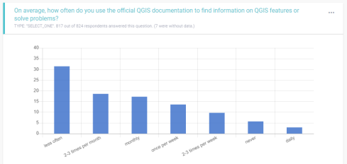
The answers to the second question show that most respondents look for information around 2-3 times a week:

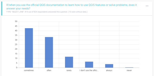
The third question asked specifically about the official QGIS documentation and answers revealed that most users sometimes or often find answers there:

Overall respondents use the official documentation rather rarely:

Finally, there was an open ended question:

You can download the full responses if you’re interested in the details.

The results and lessons we can learn from the responses are currently being discussed on the community mailing list.

Nyhet från QGIS, orginal inlägg

Publicerad den Lämna en kommentar

SimActive used to determine financial assistance after Hurricane Dorian

Photo: SimActive

Photo: SimActive

SimActive Inc., a developer of photogrammetry software, announces that its Correlator3D software has been used by Air Data Solutions (ADS) in Florida to determine financial assistance following Hurricane Dorian.

Aerial imagery was collected before the storm for pre-hurricane assessment and after for damage analysis.

A Phase One 100MP aerial camera owned by ADS was flown to gather high-resolution images of the affected areas. The data was then processed by SimActive software to create mosaics of orthophotos.

The resulting geospatial data helped government authorities to calculate recovery aid funds.

“We have been impressed by the accuracy and speed of Correlator3D to support such a time-critical mission,” said Don Cummins, President of ADS. “Combined with a high-end aerial sensor, SimActive provides the best tool for emergency response.”

Air Data Solutions is an aerial, terrestrial, and aquatic data collection and modeling company.

Publicerad den Lämna en kommentar

LiDARUSA offers new aircraft to carry full range of UAV scanners

Photo: Innoflight Technology

Photo: Innoflight Technology

LiDARUSA has announced a partnership with Innoflight Technology, a manufacturer specializing in UAV systems for surveying, mapping and inspection.

As a result of the partnership, LiDARUSA is offering the Galaxy 950 platform to carry any of its sensors while consistently providing flight times over 30 minutes.

Based in Somerville, Alabama, LiDARUSA specializes in the design and integration of economical lidar sensors.

Innoflight and LiDARUSA’s partnership is another step for both companies to offer turn-key solutions focused on quickly and safely acquiring high-quality data.

Innoflight designed the Galaxy 950 to simplify the flying aspect of remote sensing with UAVs. The helicopter includes a parachute, automatic takeoff and landing, and extended visual-line-of-sight capabilities to maximize productive time.

For corridor/electric utility line projects, the Galaxy 950 pairs well with the recently announced CL-90 by Teledyne Optech. As the first integration partner of the new compact lidar system, LiDARUSA is offering maximum productivity at UAV flight ceilings while achieving improved canopy penetration and exceptional downward point density.

“LiDARUSA and Innoflight Technology are both committed to customer success, and this partnership provides the whole package for lidar mapping solutions with UAV,” said Jeff Fagerman, CEO of LiDARUSA. “Innoflight’s Galaxy 950 offers exceptional performance in safety, flight duration, and ease of use, which is what our customers need for their projects.”

The Galaxy 950 is now available from LiDARUSA as an integrated package with any of their scanning systems.

Publicerad den Lämna en kommentar

EGNOS GEO-3’s launch satellite has solar array problem

Eutelsat Communications is investigating an incident on one of the two solar arrays on its Eutelsat 5 West B satellite. The satellite, launched Oct. 9, carries a payload for the European GNSS Agency (GSA) called GEO-3. GEO-3 is a geostationary satellite designed to augment GNSS signals.

Eutelsat is working to assess the potential impact on the performance of the satellite and will communicate on it as quickly as possible, according to a statement from the company.

Eutelsat Communications said the satellite is fully insured against the eventuality of loss by a launch-plus-one-year insurance.

Eutelsat 5 West B hosts the GEO-3 payload of the European Geostationary Navigation Overlay System (EGNOS) under a 15-year agreement signed in 2017 with the European GNSS Agency (GSA), and valued at approximately $112 million dollars (102 million euros).

The EGNOS payload, manufactured by Airbus Defence and Space, will hone the accuracy of satellite navigation signals over Europe for use in aviation, maritime and other industries as part of the European Geostationary Navigation Overlay System (EGNOS).

Revenues generated in Financial Year (FY) 2018-19 by Eutelsat 5 West A, the satellite that West B is intended to replace, amounted to about $33.3 million (30 million euros).


Feature image: Orbit ATK

Publicerad den Lämna en kommentar

Geneq launches SXPad 1500 rugged data collector

The New Handheld Is Designed for Data Collection for Land Surveying and Geospatial Information Systems (GIS)

Photo: Geneq

Photo: Geneq

Geneq Inc. has added a new data collector to its SXPad product line. The rugged SXPad 1500 data collector features a full alphanumeric QWERTY keypad and long-range Bluetooth, and was designed to meet the rigorous IP67 standard to deal with challenging field conditions.

The SXPad 1500 and its large 5-inch sunlight-readable touchscreen can be connected to any GNSS receiver or compatible robotic total station to ensure the success of all survey projects.

Driven by a 1-GHz processor and the Windows Mobile 6.5 operating system, the field collector is a high-performance device designed to provide the power needed to work with maps and large data sets in the field, as well as many software solutions.

With its integrated cellular modem and Wi-Fi standard, the SXPad 1500 offers wireless connectivity for internet access and GIS data transfer. This feature will be helpful for setting parameters and configuring the SXblue PREMIER and F90 or any real-time kinematic (RTK)-compatible GNSS receiver.

The SXPad 1500 has a GNSS internal module that delivers adequate performance for certain GIS field data collections.

Equipped with an internal memory of 1 GB (memory can be expanded to 16 GB with an SD card), the SXPad 1500 provides enough storage space for data recording. Users will benefit from its high-performance lithium battery allowing uninterrupted field operation for up to 8 hours.