Publicerad den Lämna en kommentar

Thales awarded GSA grant for GIANO Galileo receiver

Photo: Canetti / iStock / Getty Images Plus

Photo: Canetti / iStock / Getty Images Plus

News from the European GNSS Agency (GSA)

Thales Alenia Space has been awarded a grant under the European GNSS Agency’s (GSA) Fundamental Elements funding mechanism for the development of the GIANO (Galileo-based TIming Receiver for CriticAl INfrastructure Robustness) receiver, which aims to make critical infrastructure more robust against interference, jamming and spoofing.

In an increasingly complex GNSS environment in which there is both unintentional and deliberate disruption of satellite signals, the GSA is funding the development of a timing receiver for professional applications to address the needs of the critical infrastructure user community, mainly energy generation and distribution, telecommunications and financial operators.

Improved resilience

The GIANO receiver will leverage Galileo and EGNOS-driven innovation to improve the resilience of the receiver against interference, jamming and spoofing and increase the accuracy and reliability of the time transfer service. The timing platform prototype to be developed and validated will integrate all the latest innovative technologies, including professional products from Thales Alenia Space, paving the way for future Galileo-based timing receivers that offer improved resilience and accuracy at a reasonable cost.

“Critical infrastructure operators use GNSS for timing and synchronisation and are an important target segment for GSA Market Development because Galileo can make a difference. By funding the development of the GIANO receiver, the GSA aims to provide technological solutions to this community for robust and reliable timing,” said GSA head of market development Fiammetta Diani.

Toward this goal, outreach activities have been conducted among potential final users in the main commercial target groups to collect and analyse their needs. Then, following the definition and consolidation of stakeholders’ needs and the platform specifications, the project conducted a preliminary design review at the end of November 2019.

Europe-wide cooperation

The two-year project, funded under a GSA grant related to the Development of a Galileo-based timing receiver for critical infrastructures (GSA/GRANT/05/2017), will be coordinated by Thales Alenia Space in Italy, in collaboration with four European partners: Business Integration Partners S.p.A (BIP, Italy), PIKTime Systems (Poland), Space Research Centre of the Polish Academy of Science (SRC PAS, Poland) and DEIMOS (Portugal).

The project will also benefit from the support of the European Commission’s in-house science service – the Joint Research Centre (JRC) and the Italian National Metrology Institute (INRIM), which will make available its test facilities for verification activities on the developed equipment.

Publicerad den Lämna en kommentar

Broadcom’s second-generation dual-frequency GNSS uses L5 signals

BCM4776 chip utilizes 30 new L5 signals to deliver higher navigational accuracy and yield

Photo: Broadcom

Photo: Broadcom

Broadcom introduced in 2017 the first mass-market implementation of dual frequency: BCM4775. This chip makes use not only of the classic L1 frequency broadcast by every satellite, but also of the more advanced L5 signal broadcast by a subset of the satellites.

The use of this enhanced L5 signal improves the accuracy of GNSS in an urban scenario, as it mitigates the main source of error: the reflections in the nearby buildings, also known as multipath. It also improves GNSS in an open-sky scenario, allowing submeter accuracy, a previously unmet performance bar in smartphones until now. Ever since, the BCM4775 has been adopted in flagship smartphones, smartwatches and fitness devices.

Given the unabated need for better precision and accuracy, Broadcom has introduced its second-generation dual-frequency GNSS solution — the BCM4776.

The new chip is capable of using the new BeiDou-3 constellation’s B2a signals (the Chinese indicator for L5). It will be able to track 30 new L5 signals (60 percent more) with a significant impact on accuracy. End users will experience much higher reliability of the submeter accuracy inherent to dual-frequency L1-L5.

Image: Broadcom

Image: Broadcom

Second generation dual-frequency GNSS will be used for innovative lane-level driving navigation instructions, allowing driving applications to know which highway lane the vehicle is in. Expect instructions like “move one lane to the right so you don’t miss your next highway exit” or “move one lane to the left to take the pool lane and save 10 minutes.”

The BCM4776 is now in production.

Publicerad den Lämna en kommentar

Qualcomm Snapdragon Ride platform designed for autonomous vehicles

Qualcomm Technologies unveiled at CES 2020 its newest addition to the company’s portfolio of automotive products — the Qualcomm Snapdragon Ride Platform.

Snapdragon Ride is an advanced, scalable and open autonomous driving solution consisting of the family of Snapdragon Ride Safety system-on-chips (SoCs), Snapdragon Ride Safety Accelerator and Snapdragon Ride Autonomous Stack.

CES 2020, the massive annual consumer electronics show, is taking place Jan. 7-10 in Las Vegas.

Snapdragon Ride aims to address the complexity of autonomous driving and ADAS by leveraging its high-performance, power-efficient hardware, industry-leading artificial intelligence (AI) technologies and pioneering autonomous driving stack to deliver a comprehensive, cost and energy efficient systems solution.

The unique combination of Snapdragon Ride SoCs, accelerator and autonomous stack offers automakers a scalable solution designed to support three industry segments of autonomous systems, namely L1/L2 Active Safety ADAS for vehicles that include automatic emergency braking, traffic sign recognition and lane keeping assist functions; L2+ Convenience ADAS for vehicles featuring Automated Highway Driving, Self-Parking and Urban Driving in Stop-and-Go traffic; and L4/L5 Fully Autonomous Driving for autonomous urban driving, robo-taxis and robo-logistics.

The Snapdragon Ride Platform, based on the Snapdragon family of automotive SoCs and accelerator, is built on scalable and modular heterogeneous high-performance multi-core CPUs, energy efficient AI and computer vision (CV) engines, industry-leading GPU.

At the Qualcomm CES 2020 press conference, President Cristiano Amon introduced Snapdragon Ride. (Photo: Qualcomm)

At the Qualcomm CES 2020 press conference, President Cristiano Amon introduced Snapdragon Ride. (Photo: Qualcomm)

The platform with combination of SoCs and accelerator can be used as needed to address every market segment offering industry-leading thermal efficiency, from 30 Tera Operations Per Second (TOPS) for L1/L2 applications to over 700 TOPS at 130W for L4/L5 driving.

The platform can therefore result in designs that can be passively or air-cooled, thereby reducing cost, and increasing reliability, avoiding the need for expensive liquid cooled systems and allowing for simpler vehicle designs, and extending the driving range for electric vehicles. The Snapdragon Ride SoCs and accelerator are designed for functional safety ASIL-D systems.

Snapdragon Ride is expected to be available for pre-development to automakers and tier-1 suppliers in the first half of 2020. Qualcomm Technologies anticipates Snapdragon Ride-enabled vehicles to be in production in 2023.

While the company believes the next wave of innovation may be in the L2+ Convenience ADAS segment, the hardware solutions utilized in Snapdragon Ride from a single system-on-chip (SoC) for an Active Safety ADAS system driven by regulatory mandates to a highly scalable architecture of multiple SoCs and dedicated autonomous driving accelerators allowing for fully autonomous self-driving systems.

Qualcomm Technologies’ family of ADAS SoCs and accelerators are built on the fundamental approach of heterogeneous compute capabilities designed for application requirements.

These ADAS SoCs and accelerators effectively manage a large amount of data from onboard systems, leveraging Qualcomm Technologies’ next generation AI engines; image signal processors for camera sensors; enhanced digital signal processors (DSPs) for sensor signal processing; high-performance CPUs for planning and decision making; cutting-edge GPU technology for high-end visualization and immersive user experience; dedicated safety and security subsystems across the SoC and autonomous driving accelerator.

Through the autonomous driving accelerator, Qualcomm Technologies brings energy efficient compute capabilities to mainstream vehicles, which has so far been largely unavailable to the automotive industry due to exceptionally complex and expensive thermal solutions that are fundamentally unscalable because of their power consumption requirements.


Snapdragon Ride Benefits

  • Proven and integrated safety board support package with safe OS and hypervisors
  • Safety frameworks from automotive industry leaders, including Adaptive AUTOSAR
  • Optimized and comprehensive foundational function libraries for computer vision, sensor signal processing, and standard arithmetic libraries
  • AI tools for improving model efficiencies, as well as optimizing runtime on heterogeneous compute units
  • Comprehensive autonomous driving stack for highway functions, such as perception and planning for highway driving functions
  • Cost-efficient localization solution with Qualcomm Vision Enhanced Precise Positioning (VEPP)
  • Hardware and Software in Loop Test environment
  • Data Management Tools for intelligent data collection and automated annotation

Autonomous Stack

Integrated as a part of Snapdragon Ride is Qualcomm Technologies’ new purpose-built autonomous driving software stack, a modular and scalable solution available to automotive OEM and tier-1 suppliers to accelerate their development and innovations.

The software stack facilitates automakers’ abilities to offer increased safety and comfort to everyday driving by offering optimized software and applications for complex use cases, such as self-navigating human-like highway driving, as well as choice of modular options like perception, localization, sensor fusion and behavior planning.

The software infrastructure for Snapdragon Ride supports customer specific stack components to be co-hosted with the Snapdragon Ride Autonomous Stack components.

“Over the years, we have consistently demonstrated our prowess in large-scale deployment of high-performance and highly intelligent cockpit and connected car solutions that operate in power-constrained environments across virtually every class of vehicle. Today, we are pleased to be introducing our first-generation Snapdragon Ride platform, which is highly scalable, open, fully customizable and highly power optimized autonomous driving solution designed to address a range of requirements from NCAP to L2+ Highway Autopilot to Robo Taxis. Combined with our Snapdragon Ride Autonomous Stack, or an automaker or tier-1’s own algorithms, our platform aims at accelerating the deployment of high-performance autonomous driving to mass market vehicles,” said Nakul Duggal, senior vice president, product management, Qualcomm Technologies, Inc. “We’ve spent the last several years researching and developing our new autonomous platform and accompanying driving stack, identifying challenges and gathering insights from data analysis to address the complexities automakers want to solve.”

Publicerad den Lämna en kommentar

HERE’s new HD GNSS enables sub-meter positioning for mass market

The company also announces that HERE Navigation On-Demand is OEM-ready with APCOA as partner

HERE Technologies has introduced at CES 2020  its High Definition Global Navigation Satellite System (HD GNSS) positioning, a cloud-based solution that enables mass-market devices to achieve sub-meter accuracy across the globe.

CES 2020, the massive annual consumer electronics show, is taking place Jan. 7-10 in Las Vegas. Here’s booth is at Central Plaza, Tech East.

HD GNSS enables new user experiences with lane-level navigation, augmented and virtual reality. It combines precise point positioning (PPP) and real-time kinematic (RTK) positioning methods, allowing for fast convergence time, high availability and global coverage.

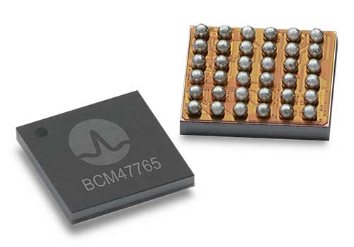
It also supports off-the-shelf mobile devices and internet of things (IoT) trackers equipped with dual frequency chipsets such as the Broadcom BCM47765 and BCM47755.

Photo: HERE

Photo: HERE

More mass-market devices and vehicles are being equipped with dual-frequency GNSS receivers. With the HD GNSS service, the receivers enable high-precision positioning, HERE said, a capability that was cost and geographically prohibitive less than two years ago.

HERE HD GNSS accelerates chipset, hardware and software makers’ ability to offer a step change in what can be delivered to consumers in new product capabilities, features and user experiences, the company said.

HERE HD GNSS data delivery is optimized for mobile devices, requires no additional hardware and comes equipped with spoofing detection and phone sensor integration. It provides global coverage (including China and Japan), with single-frequency mobile device support in the future.

HERE is also working across a partner ecosystem — including reference station operators, chipset manufacturers, module makers, hardware vendors, mobile network operators and system integrators — to jointly improve the positioning accuracy to centimeter levels, and in more challenging environments such as urban canyons.


Automotive use cases

Autonomous driving. For safety, it’s critical that automated vehicles are designed with high levels of redundancy in positioning systems. If an automated vehicle gets caught in bad weather conditions which are degrading optical sensor operations, <0.2m positioning accuracy available via HD GNSS increases safety and operation time in autonomous mode.

Assisted driving. In case of an obstacle on the road, HD GNSS combined with HERE HD maps provide obstacle indication and avoidance functionality.

Mobile device use cases

Road lane guidance and improved ETAs on mobile devices. If a driver is unfamiliar with the roadway, HERE HD GNSS, combined with precision HERE map data, shows the driver the correct lane and path to navigate to the destination fast and safely.

Improved gaming and augmented reality experience. Location-based games are growing and widely popular, however they currently rely on less accurate positioning technologies that inhibit next generation use cases. HERE HD GNSS bring exciting opportunities to design the next version of games with sub-meter positional accuracy.


HERE Navigation On-Demand is OEM-ready with APCOA as partner

HERE Navigation On-Demand is now available for integration in OEM infotainment programs. APCOA Parking is the first non-automotive company to use the Service Package SDK to make its parking services available on HERE Navigation On-Demand.

HERE Technologies’ software-as-a-service solution HERE Navigation On-Demand is available for integration in OEM infotainment programs. With HERE Navigation On-Demand, OEMs and Tier 1 vendors get to deliver both connected services and expandable navigation experiences on both embedded and mobile platforms.

The connected solution cuts development and lifecycle costs by offering cutting-edge, off-the-shelf functionalities while enabling OEMs and Tier 1 vendors to use an SDK to build their own features or integrate third party services.

As a software-as-a-service offering, HERE Navigation On-Demand enables OEMs to remotely configure and monitor the deployed navigation solution making it possible to update and upgrade the experience anytime, even after the sale of the vehicle.

OEMs can further offer any functionality as a subscription option and thus generate new, recurring revenue streams. The end-user accesses the navigation experience through client software which downloads the Service Packages from the cloud.

The highly modular Service Packages include map data, software features, UX elements and references to Cloud Service APIs. Smart caching of these Service Packages ensures that HERE Navigation On-Demand also works offline.

Alexa, Amazon’s cloud-based voice service, is pre-integrated into HERE Navigation On-Demand, making it faster and easier for automakers to deliver an intuitive, voice-first navigation experience to customers in the car.

Publicerad den Lämna en kommentar

NeQuick G code available for download

Global ionospheric map calculated with NeQuick G for the 18 09 2019 at 07 UT (DOY 261, 2019)I (Image: GSA)

Global ionospheric map calculated with NeQuick G for the 18 09 2019 at 07 UT (DOY 261, 2019). (Image: GSA)

News from the European GNSS Agency (GSA)

A version of the NeQuick G algorithm using a new coding approach is now available for download on the GSC website. This version is the result of intensive recoding by engineers at the EU’s Joint Research Centre.

GNSS signals traveling through the ionosphere can be significantly delayed by the electrical charges in this atmospheric layer before reaching the users’ terminal. To compensate for this delay in the signal, Galileo receivers integrate a dynamic model of the ionosphere composition known as the NeQuick G model.

Receiver manufacturers will now be able to benefit from a version of the NeQuick G correction algorithm that implements a new coding approach.

Rigorous testing

The JRC concluded its work recently after successful rigorous testing in the framework of the gLAB tool (GNSS software suite from the Universitat Politecnica de Catalunya). This version of the code has been designed to be highly modular, rendering it more legible for a potential programmer with no specific knowledge about signal propagation in the ionosphere. A library has been also developed to enable its quick integration into existing applications.

This software will be released as free and open source software under the terms of the European Union Public Licence (EUPL), version 1.2.

The open-source code is now ready to be implemented on single-frequency platforms and can be used on a global scale without limitation under the EUPL. This freedom should contribute to a wider adoption of the NeQuick G model at user level.

This version of the NeQuick G code is available for download on the GSC website. Users can register here,  and then download the software here.

Publicerad den Lämna en kommentar

Swift Navigation kicks off 2020 with precision and partnerships

logoSwift ​​Navigation​, ​​a firm specializing in GNSS positioning technology for autonomous vehicles, looks back on a year of progress in 2019 and forward to what’s ahead in 2020.

2019 highlights include the expansion of operations to Australia, continued Firmware Releases to improve Swift’s multi-band, multi-constellation GNSS receivers, the expansion of Skylark cloud corrections service across the United States and announcing a partnership with Arm to bring precise positioning technology to autonomous vehicle compute platforms.

While Swift is proud of these accomplishments, the company is most excited about its shift from a company providing RTK GNSS receivers to one that provides a full ecosystem of precise positioning GNSS solutions for autonomous and mass-market applications.

Swift has made it possible for customers and partners alike to incorporate Swift’s patented technology into a multitude of autonomous platforms.

From the receiver-agnostic Starling positioning engine that enables the accuracy of Swift GNSS receivers and opens it up for industry use, to cloud-based corrections delivered nationwide with Skylark, Swift is poised to bring precise positioning to those who can benefit from centimeter-level location accuracy the most — autonomous platforms and applications.

While Skylark and Starling work independently with many leading industry components and receivers, it is the two paired together that makes the precise positioning powerhouse that will make 2020 a pivotal year for Swift.

At this year’s CES, the following Swift partners and customers are showcasing how they are integrating Swift’s precision positioning solutions in their platforms:

  • Arm — a global leader in semiconductor IP — utilizes Starling to deliver a high-integrity, high-accuracy GNSS positioning solution enabling automotive OEMs, as well as Tier 1 and 2 auto suppliers, to integrate precise positioning into their sensor suite. Arm is hosting meetings by appointment on Level 2 of the Venetian at Veronese 2505 and Veronese 2506.
  • STMicroelectronics — a global semiconductor leader — provides GNSS measurement engines and ASIL-rated processors for autonomous driving and high-accuracy GNSS solutions. ST has integrated Starling on the ST ASIL-rated Telemaco Platform for OEM applications. ST is hosting meetings by appointment only at their Hospitality Suites during CES 2020.
  • Aceinna — a provider of sensing solutions — announced its OpenRTK330 precise positioning module at CES. The new OpenRTK330 is based on the ST TeseoV receiver and includes three ST ASM330LHH IMUs for inertial measurements. Skylark is the preferred corrections provider for the OpenRTK330 and evaluation kits. Aceinna will be demonstrating its new module in booth 6738 in the North Hall Automotive pavilion.

See Swift in action at the CES locations above or contact the Swift team at sales@swiftnav.com to schedule a meeting.

Publicerad den Lämna en kommentar

NovAtel delivers signal generators to modernize FAA’s WAAS

Next-generation NovAtel ground uplink station signal generators delivered for SBAS modernization

Photo: NovAtel

Photo: NovAtel

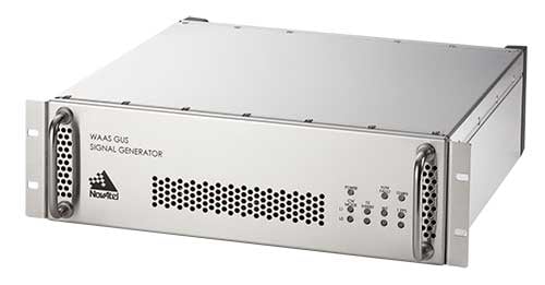
Hexagon/NovAtel announced that shipments of next-generation ground uplink station (GUS) signal generators have commenced in fulfillment of its contract with the United States Federal Aviation Administration (FAA) to support the FAA’s safety of life wide-area augmentation system (WAAS) navigation service.

Developed by the FAA for civil aviation, WAAS is a safety-critical navigation aid that provides integrity monitoring and differential corrections for all phases of flight. The next-generation NovAtel GUS signal generator replaces the legacy product that has operated successfully for more than 15 years and ensures continued operation for years to come.

Along with the GUS signal generator modernization, the contract includes ongoing engineering support services for the complete portfolio of NovAtel ground reference receiver products deployed by the FAA.

“We have a long-standing relationship with the FAA and worked very closely with the WAAS program team to deliver this critical next-generation technology for SBAS modernization,” stated Jonathan Auld, NovAtel Vice President of Engineering and Safety Critical Systems. “We’re very pleased to continue our commitment to support the FAA and their safety of life WAAS service.”

Publicerad den Lämna en kommentar

Uber and Hyundai release full-scale air taxi model at CES

Hyundai is the first Uber Elevate partner with manufacturing capabilities to mass produce Uber Air Taxis

Uber and Hyundai Motor Company announced at CES 2020 a new partnership to develop Uber Air Taxis for a future aerial ride-share network and unveiled a full-scale aircraft concept. Hyundai is the first automotive company to join the Uber Elevate initiative, bringing automotive-scale manufacturing capability and a track record of mass-producing electric vehicles.

CES 2020, the massive annual consumer electronics show, is taking place Jan. 7-10 in Las Vegas. Hyundai Motor’s innovative smart mobility solutions including UAM, PBV, Hub and more are showcased at Booth 5431 in the Las Vegas Convention Center North Hall.

The taxi concept was created in part through Uber’s open design process, a NASA-inspired approach that jump starts innovation by publicly releasing vehicle design concepts so any company can use them to innovate their air taxi models and engineering technologies.

In this partnership, Hyundai will produce and deploy the air vehicles, and Uber will provide airspace support services, connections to ground transportation, and customer interfaces through an aerial ride-share network. Both parties are collaborating on infrastructure concepts to support take-off and landing for this new class of vehicles.

The SA-1 air taxi. (Photo: Uber/Hyundai)

The SA-1 air taxi. (Photo: Uber/Hyundai)

“Our vision of urban air mobility will transform the concept of urban transportation,” said Jaiwon Shin, Executive Vice President and Head of Hyundai’s Urban Air Mobility (UAM) Division. “We expect UAM to vitalize urban communities and provide more quality time to people. We are confident that Uber Elevate is the right partner to make this innovative product readily available to as many customers as possible.”

“Hyundai is our first vehicle partner with experience of manufacturing passenger cars on a global scale. We believe Hyundai has the potential to build Uber Air vehicles at rates unseen in the current aerospace industry, producing high quality, reliable aircraft at high volumes to drive down passenger costs per trip. Combining Hyundai’s manufacturing muscle with Uber’s technology platform represents a giant leap forward for launching a vibrant air taxi network in the coming years,” said Eric Allison, head of Uber Elevate.

In preparation for this announcement, Hyundai worked with Uber Elevate to develop a PAV (personal air vehicle) model, S-A1, that uses innovative design processes to optimize electric vertical take-off and landing (eVTOL) aircraft for aerial ridesharing purposes. S-A1 previous eVTOL designs Uber Elevate has released in the following ways:

  • It is designed for a cruising speed up to 180 miles/hr (290 km/hr), a cruising altitude of around 1,000-2,000 feet (300 – 600 mt) above ground, and to fly trips up to 60 mile (100 km).
  • The Hyundai vehicle will be 100% electric, utilizing distributed electric propulsion and during peak hours will require about five to seven minutes for recharging.
  • Hyundai’s electric aircraft utilizes distributed electric propulsion, powering multiple rotors and propellers around the airframe to increase safety by decreasing any single point of failure. Having several, smaller rotors also reduces noise relative to large rotor helicopters with combustion engines, which is very important to cities.
  • The model is designed to take off vertically, transition to wing-borne lift in cruise, and then transition back to vertical flight to land.
  • The Hyundai vehicle will be piloted initially, but over time they will become autonomous.
  • The cabin is designed with four passenger seats, allowing riders to board and disembark easily and avoid the middle seat with enough space for a personal bag or backpack.

Ushering in the era of seamless mobility, Hyundai’s exploration of future urban transportation incorporates the electric PAV concept with a new ground transportation, the Purpose Built Vehicle (PBV) concept.

Hyundai’s vision for creating communities from future transit systems comes into focus with yet another new infrastructure concept, called the Hub. When many PBVs and PAVs are docked and connected to a Hub, they make a new public space where diverse groups of people can come together.

Artist's concept: Hyundai

Artist’s concept: Hyundai

Publicerad den Lämna en kommentar

US prepares for drone strikes against Middle East targets

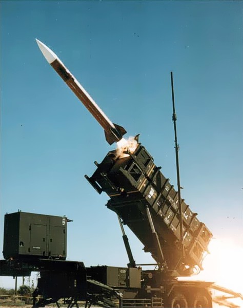
A Patriot missile launch. (Photo: U.S. Army)

A Patriot missile launch.
(Photo: U.S. Army)

U.S. forces and air-defense missile batteries across the Middle East were placed on high alert Jan. 7 in preparation for possible Iranian drone attacks, reports CNN, including all Patriot batteries and forces in the area.

U.S. officials told CNN that intelligence mounted about a threat of an imminent attack against U.S. targets in the wake of the U.S. drone strike that killed Iranian general Qasem Soleimani. U.S. intelligence also observed Iran moving military equipment, including drones and ballistic missiles, over the last several days.

The movement may be an Iranian effort to secure its weapons from a potential U.S. strike, or put them in positions to launch their own attacks.

Iran has put missiles on its drones that have been used in other attacks, including a significant attack on Saudi oil installations last year (see below).

Targets of concern are U.S. locations in Iraq, Kuwait, Saudi Arabia, the United Arab Emirates and Jordan.

2019 Drone Tensions

Drones forces from both sides targeted assets in 2019. In June, Iran shot down a U.S. military drone that it claimed was an intruding American spy drone entering its territory. The U.S. said the drone was shot down in international airspace over the Strait of Hormuz.

In July, U.S. Marines jammed and destroyed an Iranian drone in the Strait of Hormuz from aboard the USS Boxer, an amphibious assault ship, because the drone has closed too close, to approximately 1,000 yards. Iran denied losing any of its drones.

In September, Iran was blamed for an attack on the Saudi oil industry, with drones and cruise missiles assumed launched from an Iranian base in Iran close to the border with Iraq. The Abqaiq oil plant was struck by more than a dozen projectiles.

Maritime Alert

On Monday, the U.S. Maritime Administration issued an alert to commercial vessels operating in the Middle East, citing multiple maritime threats and stating “there remains the possibility of Iranian action against U.S. maritime interests in the region.”

According to the alert, “The U.S. government is continually assessing the maritime security situation in the region to safeguard freedom of navigation, ensure the free flow of commerce, and protect U.S. vessels, personnel, and interests.

“U.S. Fifth Fleet Naval Cooperation and Guidance for Shipping (NCAGS) has the latest information on the dynamic maritime security threats and operational environment in this region. U.S. commercial vessels are advised to exercise caution and coordinate vessel voyage planning for transits of the Persian Gulf, Strait of Hormuz, Gulf of Oman, North Arabian Sea, Gulf of Aden, and Red Sea with NCAGS and follow NCAGS’s recommendations and guidance whenever possible.”

Publicerad den Lämna en kommentar

AVL adds Rohde & Schwarz GNSS simulation to vehicle test environment

A collaboration between AVL and Rohde & Schwarz, two providers of measuring and automotive testing systems, now permits the reproduction of realistic GNSS reception conditions for testbed vehicle testing. As a result, users can reliably test all aspects of GNSS-based vehicle positioning — a core functionality of autonomous vehicles.

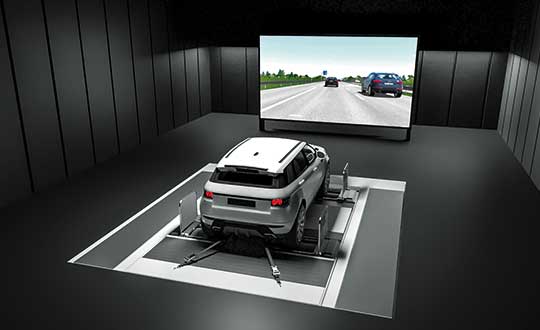
AVL DRIVINGCUBE enables the reproducible testing of driver assistance systems and driving features for self-driving vehicles using a real vehicle within a virtual environment in a variety of different traffic situations. For that purpose, test drives are performed with a real, ready-to-drive vehicle on a chassis dynamometer or powertrain testbed.

With the help of realistic virtual driving scenarios, it is possible to test peripheral sensors, control systems and actuators inside the vehicle in a fully reproducible and reliable manner. Automated vehicle functions are thus sufficiently validated during development and even before testing on the proving ground.

The range of environment simulations carried out with AVL DRIVINGCUBE can now be extended to include GNSS signals, bringing simulation closer to reality than ever before. The vehicle’s GNSS receiver is stimulated realistically using GNSS signals generated on the testbed.

This way, technical engineers can identify exactly how sensors, automated driving features and other actuators respond inside the vehicle. The now possible GNSS-based vehicle positioning feature is a core functionality of automated driving, and the approach ensures that it is reliably tested.

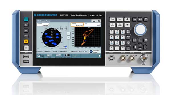
The SMBV100B GNSS simulator. (Photo: Rohde & Schwarz)

The SMBV100B GNSS simulator. (Photo: Rohde & Schwarz)

For generating GNSS signals, Rohde & Schwarz GNSS simulators are used (R&S SMBV100B or R&S SMW200A), which allow the generation of signals for all of the available satellite navigation systems (GPS, Glonass, Galileo, BeiDou, QZSS, SBAS) across all frequency bandwidths (L1, L2, L5). This also makes them suitable for testing multi-frequency receivers, which are playing an increasingly important role in automated driving.

“In Rohde & Schwarz, we now have a strong and reliable partner for GNSS stimulation. By generating consistent GNSS signals in connection with environment simulation, AVL DRIVINGCUBE now provides a test system that allows users to validate GNSS-based driver assistance systems and autonomous driving features,” explains Dr.-Ing. Tobias Düser, Head of Advanced Solution Lab at AVL Deutschland GmbH.

Christoph Pointner, Head of Signal Generators at Rohde & Schwarz, adds: “We are very pleased to bring our expertise in the field of signal generation to this collaboration with AVL and contribute to such an important innovation and trendsetting solution for testing automatized driving features.”

The additional GNSS stimulation makes testbed testing not only more realistic, it is above all a further step in moving testing from the road to the rig. This leads to a much sharper reduction of test drives than was the case previously and major savings in the kilometers driven.

Rohde & Schwarz GNSS stimulators form a flexible, modular system that can be adapted to your requirements and is easily integrated in the AVL DRIVINGCUBE environment. The stimulator is controlled automatically from the simulation platform. GNSS extensions for AVL DRIVINGCUBE are available with immediate effect.

AVL DRIVINGCUBE enables the reproducible testing of driver assistance systems for self-driving vehicles. (Photo: AVL)

AVL DRIVINGCUBE enables the reproducible testing of driver assistance systems for self-driving vehicles. (Photo: AVL)