Publicerad den Lämna en kommentar

EGNOS payload enters service on Eutelsat 5 West B

The EGNOS payload aboard the Eutelsat 5 West B satellite has entered service, according to Eutelsat Communications. The satellite carries a payload for the European GNSS Agency (GSA) called GEO-3. GEO-3 is designed to be aboard a geostationary satellite to augment GNSS signals.

A solar-array problem affected the satellite shortly after its Oct. 9 launch.

Eutelsat 5 West B is hosting the EGNOS payload under a 15-year agreement signed in 2017 with the European GNSS Agency (GSA). The contract also includes technical services and a European ground infrastructure, including two gateways installed at Eutelsat’s Rambouillet and Cagliari teleports.

Image: GSA

Image: GSA

“Eutelsat is proud of the collaboration with its customer GSA, its partners including the European Space Agency, and its suppliers, culminating in the entry into service of this next generation technology of EGNOS on Eutelsat 5 West B,” said Yohann Leroy, Eutelsat’s Deputy CEO and Chief Technical Officer. “We are delighted to host this payload, which will significantly enhance the performance of global navigation satellite systems across Europe, notably Galileo, in the coming years.”

“With this new payload in service, EGNOS is moving towards the transition to its new generation,” said Pascal Claudel, GSA acting executive director and CEO. “This has been done thanks to the constructive collaboration with Eutelsat. Delivery and continuity of satellite services are part of our mission as delegated by the European Commission. It is essential that we, at the GSA, ensure these services to support economic growth and that the European Union’s citizens and companies can benefit from the latest GNSS technology.”

Publicerad den Lämna en kommentar

UAV Navigation compatible with new Trimble UAS1 GNSS receiver

UAV Navigation announced today that its flight control solutions for remotely piloted air systems/unmanned aerial vehicles (RPAS/UAVs) are compatible with the Trimble UAS1, a high-precision GNSS receiver. The core benefits of Trimble’s GNSS solution include centimeter-level precision and easy integration.

Image: UAV Navigation and Trimble

Image: UAV Navigation and Trimble

The light, small Trimble UAS1 receiver is less vulnerable to vibrations or temperature fluctuations, making it suitable for UAVs and RPAS. In addition, the receiver can provide real-time kinematic (RTK) positioning using a base station, enabling users to achieve higher precision for their projects.

Most UAV missions demand precision in its subsystems. The Trimble UAS1 receiver meets these requirements and includes a 336-channel high-precision GNSS engine. It tracks L1/L2 frequencies from the GPS, GLONASS, Galileo and BeiDou constellations.

The Trimble UAS1 supports OmniSTAR and Trimble CenterPoint RTX GNSS corrections, which enable precise and robust positioning without the use of a base station via a subscription service. The receiver also offers an industry-standard camera hot-shoe interface and a wide DC voltage range to work in a broad range of UAVs.

While Trimble is highly specialized in providing advanced GNSS solutions, UAV Navigation’s focus is on innovations in flight control systems. With this combined technology, current UAV/RPAS systems can now operate in more demanding environments and deliver higher precision through better navigation, UAV Navigation stated in a press release.

Publicerad den Lämna en kommentar

Septentrio launches online shop for GNSS receivers

Image: Septentrio

Image: Septentrio

Septentrio’s new web shop offers direct access to mosaic multi-frequency GNSS receiver module. Customers can purchase the mosaic development kit quickly and easily to evaluate this unique module.

Septentrio has opened an online store shop.septentrio.com, selling high-performance GPS/GNSS module receivers. The web shop is accessible via the Septentrio website, offering customers multi-constellation multi-frequency GNSS technology, which provides reliable centimeter level positions suitable for demanding applications.

The first product available for sale online is mosaic, Septentrio’s most compact GNSS receiver module. This light-weight, low-power receiver brings robust high-accuracy positioning to the mass market. With its security-centered anti-jamming and anti-spoofing technology, mosaic provides positioning to numerous demanding applications such as automotive ADAS, logistics automation, and robotics.

“We see a growing demand for reliable high-accuracy positioning across various industries. As GNSS receivers move towards becoming a commodity, we are providing our customers with easier and faster access to GNSS technology,” said Francois Freulon, senior product manager, Septentrio. “We are happy to offer the mosaic development kit as the first product in the shop, which makes it easy for people to purchase and evaluate the mosaic module and discover its capabilities for delivering robust, highly-accurate positions. “

True multi-frequency multi-constellation technology of mosaic ensures access to every possible signal from all available GNSS constellations including the U.S. GPS, European Galileo, Russian GLONASS, Chinese BeiDou and Japanese QZSS satellites. Septentrio’s advanced field-proven algorithms exploit this signal diversity to deliver maximum positioning availability even in the most difficult environments such as under foliage or in urban areas.

GNSS signals can become jammed by nearby electronics or illegal jammers that emit radio signals interfering with GNSS. Mosaic uses jamming-resistant signal processing making it robust against interference. Its design focuses on continuous, reliable high-accuracy positioning making mosaic suitable for demanding applications such as ADAS, UAVs and industrial automation.

Publicerad den Lämna en kommentar

Executive Order requires resilience of critical PNT infrastructure

On Feb. 12, President Donald Trump signed an Executive Order establishing a comprehensive national policy to promote the responsible use of positioning, navigation and timing (PNT) services by the federal government.

The order directs federal agencies to take steps to reduce disruption of critical infrastructure that relies on PNT, including GPS. It also directs critical infrastructure owners and operators to strengthen their systems’ resilience.

Markets affected include including the electrical power grid, communications infrastructure and mobile devices, all modes of transportation, precision agriculture, weather forecasting and emergency response.

The federal government will engage both the public and private sectors to identify and promote responsible use of PNT services, with the goal of ensuring that “critical infrastructure can withstand disruption or manipulation of PNT services.”

“Because of the widespread adoption of PNT services, the disruption or manipulation of these services has the potential to adversely affect the national and economic security of the United States,” the order states. “To strengthen national resilience, the Federal Government must foster the responsible use of PNT services by critical infrastructure owners and operators,” the order reads.

PNT Profiles

The Commerce Department is tasked with developing PNT profiles, due a year from today, for PNT-dependent  systems, networks and assets. The profiles will be developed through consultation with the private sector.

The profiles will also:

  • identify appropriate PNT services;
  • detect the disruption and manipulation of PNT services; and
  • manage the associated risks to the systems, networks and assets dependent on PNT services.

The profiles will be reviewed and updated every two years.

Reaction to the Order

Reacting to the Executive Order on PNT,  J. David Grossman, executive director of the GPS Innovation Alliance (GPSIA), stated:

“The GPS Innovation Alliance (GPSIA) welcomes today’s Executive Order recognizing the critical economic and societal benefits of GPS and other Global Navigation Satellite Systems (GNSS). Resiliency is among the core attributes that have made GPS the gold standard for delivering positioning, navigation, and timing (PNT) functions to our military as well as a wide range of other sectors, including transportation, agriculture, electricity, and finance. Today’s Executive Order represents a crucial next step in ongoing efforts to maintain the security, robustness, and redundancy of PNT capabilities, including GPS, that millions of Americans rely on every day. GPSIA looks forward to working with key government stakeholders to support the implementation of this effort.”

The Department of Transportation stated,

“Our challenge is to enable increased resilience across our transportation systems and ensure the traveling public and freight transporters experience an increased level of safety and efficiency without the possibility of interference caused by loss or manipulation of PNT.

Department of Homeland Security Acting Secretary Chad F. Wolf said,

“From mobile phone applications to automobile navigation, our digital, interconnected society is dependent every day on PNT services.That is why it’s critically important that PNT services remain properly functioning as a major component of the nation’s critical infrastructure. By adopting responsible use of PNT services, the federal government and owners and operators of critical infrastructure can contribute meaningfully to national resilience and ensure the continuous, uninterrupted delivery of services to the nation.”

Photo: adamkaz/E+/Getty Images

Photo: adamkaz/E+/Getty Images

Publicerad den Lämna en kommentar

Orolia’s Sarbe Evo line meets new Cospas-Sarsat requirements

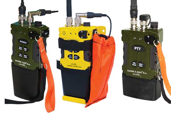
The new line of Sarbe search and rescue beacons. (Photo: Orolia)

The new line of Sarbe search and rescue beacons. (Photo: Orolia)

Orolia is introducing the Sarbe Evo line at the Singapore Air Show, taking place at the Changi Exhibition Centre Feb. 11-16. The line is being exhibited at Orolia’s Booth G10.

The search-and-rescue (SAR) beacon range has been improved to deliver upgraded operational capabilities, to meet the latest Cospas-Sarsat testability and maintenance requirements.

Part of Orolia since 2011, the Sarbe brand is a worldwide market leader for military (tri-forces) Personal Locator Beacons and Emergency Locator Transmitters. Sarbe beacons have been at the forefront of innovation in life saving Locator Beacons and critical communications for over fifty years.

Sarbe equipment is often integrated into air crew clothing such as Air Crew Life Preservers, ejection seats and survival packs, and can be optionally equipped with remote antennas and automatic activation.

The Sarbe Evo line offers new operational improvements in order to meet revised Cospas-Sarsat requirements in operating lifetime, location accuracy, voice signals management, integrated protocols, testability and maintenance.

Orolia’s development of the Sarbe Evo line has focused on the following key elements to improve customer safety:

  • Upgraded battery management with use-monitoring
  • Exceeds Cospas-Sarsat endurance requirements
  • Built-in-test further enhanced
  • More robust and frequent GPS/GNSS position acquisition with GPS, Galileo and GLONASS satellite constellations
  • Audio system improvement for greater clarity under all operating conditions
  • Introduction of the National Location Protocol
  • Rugged and reliability improvement (qualified to MIL-STD-810G standards) to support complex rescue missions in harsh environments

For both commercial and military needs in SAR operations, Orolia’s main goal remains the provision of highly accurate location data, and real-time voice and data communication to SAR operators through robust line of sight transmission.

Publicerad den Lämna en kommentar

L3Harris passes critical design review for digital GPS IIIF payload

L3Harris logoThe design improves capabilities over the 70% digital payload used for GPS III space vehicles 1-10

L3Harris Technologies passed the critical design review (CDR) phase in development of a fully digital navigation payload for the U.S. Air Force’s GPS III Follow-On satellites.

CDR is a major milestone demonstrating the new payload’s design — specifically the fully digital Mission Data Unit (MDU) — is mature enough to proceed to final development, test and delivery.

The new MDU is the heart of the navigation payload and will provide more powerful signals and ensure flawless atomic clock operations. It will also provide improved capabilities over L3Harris’ 70% digital MDU used for GPS III space vehicles 1-10 (GPS III SV 1-10).

“The digital payload is flexible enough to adapt to advances in GPS technology and future warfighter mission needs,” said Ed Zoiss, president, Space and Airborne Systems, L3Harris. “Proceeding to the next stage in the GPS IIIF navigation payload development process moves the program closer to supporting evolving Air Force mission requirements.”

In September 2018, the Air Force selected GPS III prime contractor Lockheed Martin to build up to 22 GPS IIIF satellites, which add even more capabilities and technology to the new GPS III satellites — including the new fully digital navigation payload. GPS IIIF SV11 and 12 are currently under contract.

L3Harris is in a production cadence, having delivered to Lockheed Martin in July the eighth of 10 navigation payloads for the first 10 GPS III satellites.

GPS III SV 01 and 02 launched in December 2018 and August 2019 respectively, and are performing well on orbit. GPS III SV03 is expected to launch in April.

The remaining payloads are in various stages of integration with the satellites in Lockheed’s Colorado facility. L3Harris has provided navigation technology for every U.S. GPS satellite ever launched.

Publicerad den Lämna en kommentar

Routescene 3D mapping solution reveals hotspots at Chernobyl

Logo: Routescene

Researchers from the U.K.’s National Centre for Nuclear Robotics (NCNR) are using Routescene’s UAV lidar technology to map radioactive hotspots in Chernobyl’s Red Forest.

Professor Tom Scott, from the School of Physics at the University of Bristol, U.K., led a group of researchers from NCNR to conduct surveys on multiple sites of interest, including the Buriakivka village, a settlement abandoned following contamination from the power plant accident, and the “Red Forest,” a natural woodland area located the closest to the reactor.

Working closely with local Ukrainian authorities, the team operated unmanned aerial vehicles (UAVs) — Routescene’s LidarPods flown on DJI M600 hexacopter drones — to perform a series of radiation mapping surveys over the course of 10 days.

According to Routescene, the point cloud data collected was processing using its LidarViewer Pro software to generate a detailed digital terrain model. It was then overlaid with the results from a gamma spectrometer survey, undertaken to measure radiation intensity, to locate the exact sites of the radiation hotspots.

“The algorithm converts the aerial radiation intensity recorded by a UAV survey into a ground intensity map,” said Kieran Wood, senior research associate at the University of Bristol. “This process is heavily affected by the distance between the airborne radiation sensor and the ground/buildings. Hence, high accuracy lidar-based models were essential.”

Results

While the general widespread radiation contamination in the Red Forest was already known, the results revealed that the radioactivity was unevenly disturbed. Although radiation intensity had reduced in some areas, other areas remain highly contaminated confirming continued danger to anyone accessing those areas, Routescene reported.

In addition, the researchers detected one unexpected hotspot in the ruins of a facility that was used to separate contaminated waste during clean-up efforts immediately after the accident.

This expedition was the first in a series of surveys NCNR will conduct in Ukraine over the next year. The new maps will help officials prevent risks to visitors to the area and the full results will be published soon, Routescene said.

Publicerad den Lämna en kommentar

Xag creates fund for drones disinfection program to fight coronavirus

Photo: Xag

Photo: Xag

Xag is setting up a 5-million-yuan fund on coronavirus response, calling for voluntary drone disinfection operations in China.

According to Xag, the 5-million-yuan fund is committed to providing Xag’s agricultural drone users with technical support to properly carry out aerial disinfectant sprays that help curb the spread of virus, especially in rural villages with weaker health system and poorer sanitation condition.

Operations will target densely populated outdoor public places and those communities having confirmed or suspected cases of coronavirus, the company added. Another focus of the initiative is to clean and disinfect medical and epidemic prevention vehicles moving between affected and unaffected areas.

According to Xag, it will cover all the spare parts and maintenance expenses for those who voluntarily engage, and disinfection actions would be taken under the permission of Centre for Disease Control and Prevention and relevant government authorities.

Publicerad den Lämna en kommentar

Phase One presents RSM 300mm camera lens at Intergeo 2019

About the Author:

Allison Barwacz is the digital media manager for North Coast Media (NCM). She completed her undergraduate degree at Ohio University where she received a Bachelor of Science in magazine journalism from the E.W. Scripps School of Journalism. She works across a number of digital platforms, which include creating e-newsletters, writing articles and posting across social media sites. She also creates content for NCM’s Pit & Quarry magazine, Portable Plants magazine and Geospatial Solutions. Her understanding of the ever-changing digital media world allows her to quickly grasp what a target audience desires and create content that is appealing and relevant for any client across any platform.

Publicerad den Lämna en kommentar

Apple applies for license to install GPS testing equipment at Apple Park

Logo: Apple

Apple has applied for a license from the Federal Communications Commission (FCC) to install GPS testing equipment within Apple Park.

For the purposes of licensing, GPS transmitters are included in radio broadcasting legislation, and enforced jointly by the FCC and the U.S. National Telecommunications and Information Administration, which is part of the Department of Commerce.

In its application, Apple named two objectives. The first objective is the “illumination of the part of the the facility, located at 1 Apple Parkway, Cupertino, California, with a GPS signal to allow for the testing and experimentation indoors for continued exploration of utilizing GPS technologies within their devices to provide innovation applications and continue to provide safe products.” Its second objective is the “further design, development and enhancement of existing GPS applications to provide greater efficiency and more effective means of utilizing GPS derived information.”

According to Apple Insider, this would mean Apple would install a GPS transmitter or repeater within Apple Park in order to better control and test its own GPS devices. Apple plans to use a GPS repeater called Metro GNSS, Apple Insider added.

The application has not yet been granted, but Apple previously applied three times for licenses to conduct tests regarding cellular and consumer radios, with each application being approved, reported Apple Insider.