Publicerad den Lämna en kommentar

DJI urges FAA to reconsider ‘flawed’ remote ID rule in 89-page response

Photo: IStock.com/valio 84sl, via FAA

Photo: IStock.com/valio 84sl, via FAA

Drone-maker DJI has filed an 89-page formal comment urging the U.S. Federal Aviation Administration (FAA) to allow drone pilots to choose which method of remote identification to use with their drones.

DJI’s filing includes an independent economic study that concludes the FAA’s Remote ID proposal would prove nine times as costly as the FAA’s estimates, imposing $5.6 billion worth of burdens on society over the next decade. The analysis finds many of those costs could be obviated if drone pilots could choose between two different methods of compliance, rather than doing both as the FAA proposed.

The economic analysis was prepared by Christian Dippon, Managing Director at NERA Economic Consulting, who considered the societal costs of the FAA’s proposed rule. He concluded the average monthly cost of a remote ID network-based service for a drone user would be $9.83, rather than the FAA’s $2.50 estimate; that demand for drones would fall 10 percent if the FAA’s proposals were imposed as written; and that total costs over 10 years would be $5.6 billion instead of the FAA’s $582 million estimate.

“We have known for years that Remote ID will be required by governments worldwide and will provide members of the public with confidence in productive drone uses, but the FAA’s deeply flawed proposal poses a real threat to how American businesses, governments, educators, photographers and enthusiasts can use drones,” said DJI vice president of Policy & Legal Affairs Brendan Schulman. “We hope our detailed economic analysis and comments, as well as tens of thousands of comments from other concerned parties, will encourage the FAA to develop a more risk-based, balanced and efficient remote ID rule, so our customers and the entire industry are not hurt by the final outcome.”

DJI’s comment was one of more than 53,000 filed by the FAA’s March 2 deadline, available at this link. DJI’s comment is also available for download.

Remote ID allows authorities to identify and monitor airborne drones in near-real time, so they can see the location of the drone as well as a serial number to identify its owner. Congress tasked the FAA in 2016 with exploring consensus-based technology standards that could lead to Remote ID regulatory solutions.

In late 2019, the FAA proposed that almost all drones should broadcast that information directly to nearby receivers, as well as transmit it over wireless networks to a service provider’s database, with an anticipated monthly subscription fee for that service.

DJI and many other drone stakeholders have instead said the FAA should let drone operators choose whether to use broadcast or network solutions for Remote ID. Any new Remote ID rule is unlikely to take effect before 2024.

Publicerad den Lämna en kommentar

HYBRiX multirotor UAV flies non-stop for 8 hours

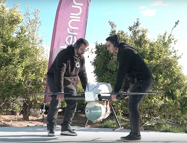
Screenshot: Quaternium video

Screenshot: Quaternium video

On Feb. 3, drone company Quaternium broke its own record for long flight time with a hybrid-fuel electric drone.

The Quaternium HYBRiX UAV took off at 08:52 a.m. in Valencia, Spain, and landed at 17:02 p.m., performing a stationary flight of 490 minutes.

The new endurance record of 8 hours and 10 minutes of non-stop flight time was accomplished with an experimental version of the company’s HYBRiX 2.1 drone, which carries 25 kilograms of maximum take-off weight.

Six years ago, the startup Quaternium developed its first hybrid fuel drone, inspired by hybrid cars from the automotive industry.

In 2015 the company flew its hybrid drone, the multirotor HYBRiX, for 3 hours and 10 minutes. According to the company, Hybrid multirotors multiply flight time more than 10 times compared to electric solutions.

The company has published a flight video with the demonstration of the record.

Most multicopter drones provide flight times of 25 to 40 minutes, with the pilot needing to carry multiple batteries into the field.

The HYBRiX project is supported by the European Union through its Horizon 2020 innovation program, which fosters disruptive projects in innovation, excellent science and industrial leadership. The project has received awards from institutions such as AUVSI, CDTI and the Spanish government.

The Quaternium team was motivated to develop a long-endurance drone because it will help first responders and and firefighters to identify hot spots and search for survivors in the event of a catastrophe, the company said in a press release.

Publicerad den Lämna en kommentar

Qualcomm makes progress on C-V2X introduction in Europe

Photo: Ficosa

Photo: Ficosa

Qualcomm Technologies’ 9150 C-V2X Platform, among several other products from automotive and infrastructure suppliers, has completed certification in accordance with the European Radio Equipment Directive (RED) Certification in Europe, a requirement for placing radio equipment on the market.

This is a major step forward toward the commercial introduction of cellular vehicle-to-everything (C-V2X) in Europe, the company said. C-V2X is a global solution for vehicle-to-vehicle and V2X communication, designed to enhance road safety and facilitate smart transportation systems. C-V2X establishes the foundation to support safety use-cases with a path for integration into next generation 5G technologies, while tapping into the broader 3GPP ecosystem to drive wider adoption. With its evolution to 5G New Radio, C-V2X offers rich and differentiated experiences consumers continue to demand as we usher in the world of 5G and autonomy, the company added.

A new European Standard defining the use of C-V2X as an access layer technology for Intelligent Transportation System (ITS) devices was recently approved through the European Telecommunication Standardization Institute (ETSI). According to Qualcomm, all the ETSI standards and specifications that define other ITS protocols above the access layer have been updated to support utilization of C-V2X as the underlying access layer. These standards and specifications have been included in the ETSI ITS Release 1 specification set and provide the basis for development of interoperable C-V2X ITS implementations and devices from multiple vendors.

Several products, all of which feature the Qualcomm 9150 C-V2X chipset solution, have achieved RED certification, including the Commsignia On-Board Unit, Commsignia Roadside Unit, Ficosa OBU, Kapsch RSU, Savari MobiWAVE 2000 OBU, Savari StreetWAVE SW2000 RSU and WNC module.

“By being one of the very first to achieve the OBU RED certification in June 2019, Ficosa continues its commitment to accelerating and expanding C-V2X as a path to 5G,” said Joan Palacin, business unit director of Ficosa Advanced Communications. “Not only in Europe but also China, USA and globally, we see C-V2X as a key technology to achieve automotive industry challenging safety goals by significantly reducing fatalities on our roads.”

Qualcomm expects early product availability to accelerate adoption of the solution in the region.

Publicerad den Lämna en kommentar

Topcon launches new options for earthmoving projects

Tilt rotation support for automatic excavation, bring-your-own device, mobile apps included

Topcon Positioning Group announces advances to its portfolio of machine control solutions that are designed to provide contractors with better performance and profitability in earthmoving applications. The new solutions include tilt rotator functionality for the Automatic Excavator system, mobile and bring your own device (BYOD) display options, and other additions.

Topcon made the announcement at ConExpo, taking place this week in Las Vegas.

Tilt and rotation for Automatic Excavator

Photo: Topcon

Photo: Topcon

Advanced tilt rotator functionality will allow Automatic Excavator operators to easily swivel or tilt the bucket with automatic boom control for faster and more efficient excavation.

“If excavator operators are in situations such as at the top of the slope, grading a long incline and not totally perpendicularly lined up, positioning the cutting edge of the bucket to the surface is now more easily attainable with the tilt rotator functionality,” said Murray Lodge, senior VP of construction.

“Operators can excavate more quickly, moving the excavator fewer times, with less wear and tear on the chassis — all with the proven hydraulic, automated control the system offers,” Lodge said. “It is also extremely beneficial when navigating around manholes, trenches, and generally tight spaces.

“We have had tilt rotation functionality for a number of years, but in previous systems,” he said. “Now, it will be available for the Automatic Excavator as well. Operators are ready for this tool, and once they see the new capabilities it will bring, they will not want to work without it.”

Bring your own device – MC Mobile

Another resource in the small excavator and compact track loader machine control offering includes bring your own device (BYOD) options that can work as a substitute for control boxes in some applications. This solution incorporates the same hardware for Topcon 3D machine control with an indicate-only option running on Android devices with a free app, Pocket-MC, which is part of the new MC Mobile system family.

“Pocket MC can be downloaded from the Google Store and used right from a phone or tablet either as a simple entry-level machine controller option for contractors who want an inexpensive way to speed up the productivity of their fleet, or as a backup on the job site to a fully featured controller — so, operators are still working, timelines keep moving,” Lodge said.

Pocket MC also allows for a local positioning system (LPS) option for excavation. Now, an LN-150 Layout Navigator total station can be used as an economical alternative to fully featured traditional total stations.

Photo: Topcon

Photo: Topcon

Sitelink3D enhancements

Enhancements also have been made to the Sitelink3D job site monitoring and management system, including a pay-as-you-go point-based service model and a Haul Truck app, giving contractors more visibility into workflow management and the flexibility to use it in the way that best fits their operation.

“These latest releases strengthening the earthmoving portfolio are part of our commitment to continually developing greater connectivity and automation for today’s job site to accelerate efficiency across all aspects of a project,” Lodge said.

Publicerad den Lämna en kommentar

Dynapac, Trimble travel ‘road to autonomy’ with soil rollers

Dynapac and Trimble are partnering to develop commercial-ready autonomy functionality for Dynapac soil rollers.

The companies first demonstrated automation of the soil compaction process at this week’s ConExpo 2020 in Las Vegas, and plans another demonstration during the Trimble Dimensions User Conference Nov. 2-4 in Nashville, Tennessee.

The Dynapac CA3600PD single-drum vibratory roller. (Photo: Dynapac)

The Dynapac CA3600PD single-drum vibratory roller. (Photo: Dynapac)

Dynapac’s “Road to Autonomy” was launched with the introduction of Seismic Soil Rollers in 2019. The Dynapac-exclusive Seismic technology takes the guesswork out of the equation for operators, regarding soil type or frequency settings, the company said.

Dynapac Seismic monitors the soil properties and automatically adjusts the frequency of vibration for optimal compaction and energy efficiency. The Active Bouncing Control System automatically cuts off the vibration of the drum when the material reaches maximum compaction characteristics.

The next step on the “Road to Autonomy” is automatic steering and speed functions on the roller. The operator/site manager can use the machine to map the boundaries of the area to be compacted.

Once the machine is placed in autonomy mode, the system will take over the controls for steering and speed. This functionality will be shown at the Dynapac and Trimble booths during ConExpo 2020.

By automating these functions, operator skill gaps can be bridged, while consistent speed and steering improve compaction quality results.

The autonomous solution is built on Trimble’s control platform and utilizes Trimble’s field-proven positioning technology. Compaction documentation systems, such as Dyn@lyzer or Trimble CCS900 Compaction Control System, work together with automatic speed and automatic steering to provide documentation of the improved quality.

Publicerad den Lämna en kommentar

Trimble launches v2 of Earthworks Grade Control Platform

Trimble’s Earthworks Grade Control Platform version 2.0, announced at ConExpo 2020, includes new features for all machine types.

Trimble also released the Trimble Earthworks Assistant App for in-cab learning material.

ConExpo 2020 is North America’s largest trade show for construction machinery, building material machines, mining machines, construction vehicles and construction equipment. The Trimble booth is located in the Las Vegas Convention Center North Hall #N-1140.

New Features

The improvements are designed to enable faster return on investment, increase productivity and decrease training time for operators.

Horizontal Steering Control for dozers automatically controls the machine to follow any horizontal alignment such as a back of a curb, breakline, roadway centerline or bottom of slope, without operator assistance.

Augmented Reality for excavators enables users to easily understand 3D models, cut/fill information, slope data and other bench points and reference points on the in-cab display in context, without the need to interpret complex 2D plans or stakes.

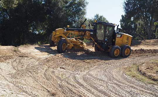
A new mastless motor grader configuration gives operators an improved range of blade motion, allowing for machine control in applications where it was previously not possible.

Integrated Trimble LOADRITE Payload Management displays grade control and accurate payload data on one screen, increasing mass haul productivity and efficiency by preventing underloading, and improving safety by avoiding overloading. Contractors can maximize their investment in Trimble Earthworks by leveraging the versatility of these added options.

Trimble Earthworks is also now available for compact grading attachments with dual GNSS, single GNSS and total station guidance options.

Horizontal Steering Control for Dozers

Horizontal Steering Control allows the operator to focus on the grade and machine productivity rather than worrying about steering, reducing operator fatigue and errors. It enables the machine to follow the horizontal guidance from the 3D model, providing operators increased awareness of their surroundings, better accuracy and improved productivity with decreased overlap and fewer passes.

“Trimble is on the forefront of innovation and cutting-edge technology along the path to automation,” said Scott Crozier, vice president, Trimble’s Civil Engineering and Construction. “Using proven steering technology from Trimble Agriculture, we are continuing to advance construction machine control yet again.”

Mastless motor grader

A new mastless motor grader configuration gives operators an improved range of blade motion. (Photo: Trimble)

A new mastless motor grader configuration gives operators an improved range of blade motion. (Photo: Trimble)

Trimble Earthworks for motor graders mastless configuration mounts one GNSS receiver on the cab and one on the gooseneck of the machine to eliminate masts and cables traditionally located on the blade. Mastless GNSS receivers are ideal for the blade’s maximum range of motion, which is needed for steep slope work and complex designs with tight tolerances. The new configuration enables contractors to decrease risk of damage to the machine, keep valuable receivers safer as well as reduce the time needed to remove and reinstall them each day.

Augmented reality for excavators

Augmented Reality was first released in the Trimble SiteVision™ system and is now available on excavators with Trimble Earthworks. Using a camera mounted on the outside of the machine, operators can view 3D models in a real-world environment at a true-life scale, in the context of existing surroundings. On the Trimble Earthworks display, the model is overlaid onto the existing ground giving the operator a better understanding of the work that needs to be done. Visibility of the bucket gives operators better situational awareness to be able to keep surrounding people and objects safe.

“With the intersection of physical and digital worlds, Trimble is empowering contractors to accelerate their business,” said Cameron Clark, business area manager, Trimble’s Civil Engineering and Construction. “Augmented Reality simplifies complex concepts by allowing users to see a blend of digital content and real-world environments.”

Earthworks Assistant App

Trimble now has an easier way to access critical Earthworks learning material and documentation, allowing for a shorter learning curve and less downtime for operators. This stand-alone app consolidates and simplifies access to training guides and videos inside and outside of the cab. The Earthworks Assistant App makes it easy to learn and troubleshoot using an Android cell phone, even from remote sites.

Publicerad den Lämna en kommentar

HERE offers location services for Microsoft Azure customers

HERE-Azure logo

Microsoft Azure customers now have access to HERE Location Services within their self-hosted Azure environments. HERE is providing a new set of application programming interfaces (APIs) for developers to build location-aware applications.

Microsoft Azure is a cloud computing service for building, testing, deploying and managing applications and services through Microsoft-managed data centers.

According to HERE, HERE Location Services such as Routing, Geocoding and Map Tiles APIs offer developers useful tools while ensuring high performance for an application’s most critical processes.

Software developers rely on the accuracy and scale of HERE Location Services to incorporate core location-oriented components into the enterprise-grade applications they build and manage, the company said.

The HERE Location Services available for self-hosting in Azure Virtual Machine environments are:

  • Routing – provides access to and use of global, real-time and historical traffic information.
  • Forward Geocoder and Reverse Geocoder – provides comprehensive coverage in 196 countries and several territories with a high-precision mapping of geo-coordinates or addresses.
  • Map Tiles – shows fresh day-time map tiles in multiple styles (for example, base and aerial) including rendered live-traffic tiles for flow overlay.

Applications for HERE Location Services include the following.

Fleet management and emergency services

  • Create safe and efficient routing solutions for multiple vehicle types
  • Provide the most efficient routing options based on real-time traffic conditions

Seamless mobility

  • Provide routing options for pedestrians and public transportation
  • Help cities run more smoothly with improved traffic flow and transportation network usage

Business intelligence:

  • Understand trends and behavior of citizens in relation to their location and mobility patterns
  • Understand shifting market dynamics to inform real-estate investments
  • Verify insurance claims and authenticate transactions

HERE Location Services are available to Azure customers who want to manage and deliver highly available location-based services. The self-hosted architecture ensures maximum availability and resiliency for Azure customers running critical business applications that rely on “always-on” location services.

“Location anchors our connected world and HERE Location Services enable industries to solve complex challenges while delivering valuable new products and experiences,” said Mithun Dhar, General Manager, Developer Relations at HERE Technologies. “Demands on business require flexibility in software architecture, and HERE is proud to offer robust and high-quality location services to customers operating across public cloud, self-hosted or hybrid environments.”

HERE Location Services are also available as Serverless Functions on the Azure Marketplace. For the latest Azure developer content, go to HERE | Azure Marketplace.

Publicerad den Lämna en kommentar

China adds to BeiDou as satnav service helps fight coronavirus

China successfully launched the penultimate Beidou navigation satellite on March 9. An official Xinhuanet news release has not yet been issued, but CGTN — a television station partially funded by the Chinese government — posted a video of the launch.

China launched the new satellite from the Xichang Satellite Launch Center in southwest China’s Sichuan Province at 19:55 Monday (Beijing Time), paving the way for its completion and full global coverage in May.

The Long March 3B/E rocket lifted off from Xichang Satellite Launch Center at 7:55 a.m. ET. The Beidou GEO-2 satellite was sent into a geosynchronous transfer orbit.

Coronavirus Fight

China has touted the BeiDou constellation’s role in helping the country fight the novel coronavirus (COVID-19) epidemic with high precision from space.

“When China was building the two makeshift hospitals — Huoshenshan (Fire God Mountain) and Leishenshan (Thunder God Mountain) in Wuhan, the epicenter of the epidemic — equipment based on the BeiDou Navigation Satellite System (BDS) provided high-precision positioning service and accelerated the construction,” stated a press release from the China Aerospace Science and Technology Corp. (CASC).

Drones based on the BDS have been utilized to spray disinfectant, according to the press release. Police in Ruichang, east China’s Jiangxi Province, used BDS-based drones to patrol crowded places to prevent intensive contact between people.

China’s Ministry of Transport sent epidemic prevention and transportation service information to more than 6 million vehicles via the BDS terminals, and provided services for the transportation of emergency materials to the areas most affected by the epidemic.

China Post Group Co. Ltd. has installed 5,000 BDS terminals on its trunk line vehicles, and used the vehicle positioning information to conduct real-time supervision and allocation, so as to ensure timely delivery of epidemic prevention materials.

In Wuhan, the BDS-based robots of the e-commerce and logistics company JD.com delivered medical materials to hospital isolation areas with high speed.

China began to construct its navigation system, named after the Chinese term for the Big Dipper constellation, in the 1990s and started serving the Asia-Pacific Region in 2012.

Over the past two years, China has successfully sent 28 BDS-3 satellites and two BDS-2 satellites into orbit.

With the system’s upgraded intelligent operation and maintenance capabilities, the BDS-3 has provided stable and accurate services, boasting a positioning accuracy of better than five meters.

China plans to launch more BDS satellites in March and May to complete the global network.

Publicerad den Lämna en kommentar

Munich Satellite Navigation Summit canceled due to coronavirus

The annual Munich Satellite Navigation Summit has been canceled.

Organizers stated, “In light of the current situation caused by the coronavirus as well as related travel restrictions and resulting cancellations we unfortunately are forced to cancel the Munich Satellite Navigation Summit 2020 as we are no longer able to provide a well-ordered and appropriate program.”

Those who were attending are asked to be pati​ent as the event organizers proceed to “sort out all necessary administrative issues.”

The summit brings together experts in industry and government; this year, it was go take place in Alte Kongresshalle, Munich, Germany.

Attendees are also told it may be possible to transfer their registration to the 2021 conference.

Publicerad den Lämna en kommentar

Esri ArcGIS map tracks global coronavirus cases

The Center for Systems Science and Engineering at Johns Hopkins University is tracking the the coronavrius, COVID-19, via an Esri ArcGIS map.

The map is updated in almost real time, and it includes a zoomable map identifying confirmed cases of the virus throughout the world. It also includes numerical data on how many cases have been confirmed in each country, as well as deaths and recoveries.

“In response to this ongoing public health emergency, we developed an interactive web-based dashboard hosted by the Center for Systems Science and Engineering at Johns Hopkins University, to visualize and track reported cases in real-time,” John Hopkins stated on its website. “The dashboard, first shared publicly on Jan. 22, illustrates the location and number of confirmed COVID-19 cases, deaths and recoveries for all affected countries. It was developed to provide researchers, public health authorities and the general public with a user-friendly tool to track the outbreak as it unfolds.”

Check out the map, titled “Coronavirus COVID-19 Global Cases by the Center for Systems Science and Engineering at Johns Hopkins University,” here.