Publicerad den Lämna en kommentar

Glonass-M satellite launched into orbit

Russia has launched another Glonass-M satellite, according to Roscosmos, the Russian State Space Corporation.

A Soyuz-2.1b launch vehicle successfully carried the satellite to its planned orbit from the Plesetsk cosmodrome. The launch took place on schedule on March 16.

Ground-based facilities of the G.S. Titov Space Forces VKS immediately took control of the satellite. A stable telemetry connection has been established and maintained with the satellite. The onboard systems of the spacecraft are operating normally.

The launch used a Fregat booster block produced by NPO Lavochkin, part of the Roscosmos State Corporation. The satellite was manufactured by ISS, also part of Roscosmos State Corporation.

The Soyuz-2.1b launch vehicle with encapsulated Glonass-M satellite is transported to the launchpad. (Screenshot: Russian Ministry of Defense video)

The Soyuz-2.1b launch vehicle with encapsulated Glonass-M satellite is transported to the launchpad. (Screenshot: Russian Ministry of Defense video)

Publicerad den Lämna en kommentar

DOT holds first GPS backup technology demonstration

Notes from DoT GPS Backup Demos – Part I

Government officials, advisors, and congressional staff gathered at NASA’s Langley Research Center on Friday, March 13. They were there to discuss the Department of Transportation’s (DoT’s) GPS Backup Technology Demonstration program and view the offerings of six different companies.

A second event to view and discuss technologies offered by the other five companies in the program is scheduled (as of this writing) for Friday, March 20, at Joint Base Cape Cod, Massachusetts.

View from Washington, D.C.

The day began with remarks by Karen Van Dyke from the U.S. Department of Transportation, as well as remarks prepared by Colonel Joseph Frankino, deputy director of the National Coordination Office, a multi-agency staff that supports the National Space-Based Positioning, Navigation, and Timing (PNT) Executive Committee, whose members were unable to attend.

Van Dyke provided an overview of the program and pointed out the increasing importance of resilient PNT. As just one example, improvements in autonomy and self-driving cars are entirely dependent upon consumers having confidence in the entire system, much of which is underpinned by PNT.

Col. Frankino’s remarks reflected the Defense Department’s commitment to and support of DoT’s resilient PNT efforts. He pointed out that the nation’s military depends upon the defense industrial base, which depends upon uninterrupted PNT.

Volpe Transportation Systems Center

The technology demonstration effort is being coordinated by Andrew Hansen from DoT’s Volpe Center. Dr. Hansen pointed out that the ongoing effort, the analysis and assessment of which is expected to be concluded in May, is a series of demonstrations vice tests. This means that the companies involved were showing what their systems could do, vice being measured against set criteria.

He also mentioned that the maturity of all the systems involved seems to have improved significantly over the last year. All are at Technical Readiness Level 6 or better. Also, that things so far had gone very smoothly with no need for any “re-dos.”

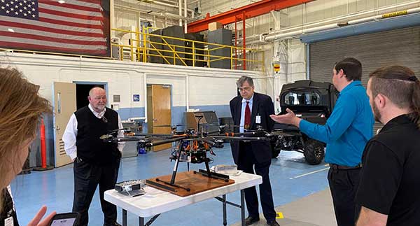
GPS and a cesium clock were being used as reference standards for the demos. Two of the systems, NextNav and Skyhook, were also demonstrated on a drone at Langley’s 150 acre open air site.

Report and Transparency

Data from the demos is not proprietary and belongs to the government which intends to make “as much of it available as possible.” DoT representatives mentioned several times their desire for maximum transparency.

Admiral (ret.) Thad Allen (left), chair of the National PNT Advisory Board, was among the attendees learning about DoT’s GPS Backup Technology Demonstration project at NASA’s Langley Research Center. (Photo: RNT Foundation)

Admiral (ret.) Thad Allen (left), chair of the National PNT Advisory Board, was among the attendees learning about DoT’s GPS Backup Technology Demonstration project at NASA’s Langley Research Center. (Photo: RNT Foundation)

Attendee Observations

After a day of viewing and discussing the six different technologies with their vendors, the group reconvened to offer feedback. All agreed the day was very worthwhile and complemented DoT and NASA on the event.

Kicking off the discussion, the DoT hosts remarked that the department is fully committed to GPS and its modernization. That said, there is broad recognition of the importance of other PNT systems. This is evidenced by the recent White House Executive Order on PNT.

Also, that there is no single solution that will fill the PNT needs of everyone. In fact, GPS does not serve the PNT needs of everyone. The need across sectors for a wide variety of sources to “backup” GPS is why the demonstration project includes some systems that only provide time, or only positioning.

Feedback from attendees included:

  • The reason for this project is that we have a 20th-century GPS and 21st-century threats. New technologies need to be examined for vulnerabilities. Security must be “baked in” from the beginning. Moderators commented that the DHS Conformance Framework was one of the tools that would help with this.
  • Rural and other underserved areas (such as wilderness, remote transportation networks, maritime) need PNT and should be a part of the government calculus.
  • Many systems depend upon infrastructure provided by others versus being self-sufficient.
  • In the view of many in Congress, it is good to see the demos going well. Overall, though, things are about two years late. Members and staff are very interested in when there will be an RFP and schedule for implementing the timing system mandated by the National Timing Resilience and Security Act of 2018.
Monty Johnson of OPNT demonstrates precise time transfer through 100 kilometers of spooled fiber-optic cable. (Photo: RNT Foundation)

Monty Johnson of the company OPNT demonstrates precise time transfer through 100 kilometers of spooled fiber-optic cable. (Photo: RNT Foundation)

Systems Demonstrated at NASA Langley

During the course of the day, attendees had the opportunity to interact with representatives from the following companies and their systems.

Vendor Service Technology
TRX Positioning Inertial Measurement Units
NextNav Positioning & Timing Metropolitan Beacons
Skyhook Positioning WiFi, cell ranging, very large proprietary database of site locations
Echo Ridge Positioning & Timing Uses Global Star LEO constellation of 24
OPNT Timing Timing Fiber & White Rabbit protocol
Seven Solutions Timing Timing Fiber & White Rabbit protocol
Publicerad den Lämna en kommentar

Komatsu partners with Cesium on Smart Construction solutions

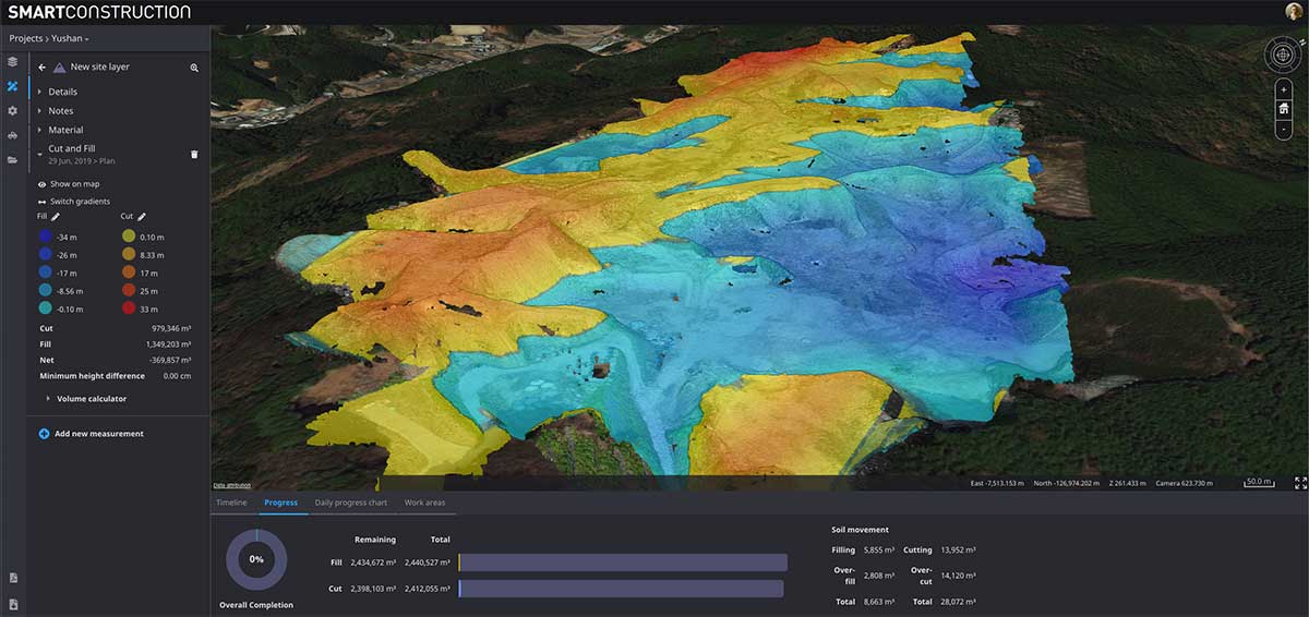
Screenshot: Cesium

Screenshot: Cesium

Cesium’s 3D technology will power smart construction dashboard to make construction safer, more efficient and more profitable

Komatsu has officially announced an incoming suite of the company’s Smart Construction solutions, which will include the 3D visualization power and geospatial accuracy of Cesium, a platform to visualize, analyze and share 3D data.

“Together, Komatsu and Cesium are bringing a new era of innovation to the construction industry,” said Rod Schrader, Chairman and CEO of Komatsu’s North American operations. “As experts in 3D data visualization, computer graphics and open-source software, Cesium’s technology will help power our Smart Construction Dashboard.”

Komatsu made the announcement at ConExpo 2020, held this week in Las Vegas.

As the key strategic partner for 3D data visualization, Cesium built the company’s Smart Construction dashboard. The dashboard enables users to monitor a construction site from anywhere in the world, see how it changes over time and compare architectural plans with real-world data.

It is compatible with different types of data — collected from sensors on individual construction machines, drone surveys, or computer generated files like BIM/CAD models — allowing users to visualize them all in a single scene within a web browser, as well as calculate precise measurements for cut and fill, slope, contours and more.

As Komatsu noted today, the worldwide construction industry is on the cusp of rapid change and innovation driven by technology. Collecting data from people and machines — and connecting all of it across an open platform — optimizes processes and delivers insights that will enable customers to make data-driven decisions.

Komatsu chose to partner with Cesium because of its powerful 3D visualization engine and accuracy in tying data to precise locations on the globe. Cesium’s ability to keep millimeter-level accuracy while tracking satellites in complex orbits was important to attain the level of precision Komatsu’s Smart Construction initiative demands.

“We believe in Komatsu’s vision to create construction sites that are safer and more efficient through Smart Construction.” said Cesium CEO Patrick Cozzi. “We are proud that visualization and analytics with the hallmark precision of Cesium will provide technology for the industry’s digital transformation.”

Publicerad den Lämna en kommentar

AUVSI Xponential show postponed until August

AUVSI Xponential 2020 logoThe AUVSI Xponential trade show has been postponed due to COVID-19, with a tentative reschedule date planned for August.

AUVSI Xponential 2020 was scheduled be held at the Boston Convention and Exhibition Center May 4-7. AUVSI has identified Aug. 10-12, as tentative dates to reschedule the event.

AUVSI Xponential is a large event for the unmanned aerial vehicle (UAV) and unmanned, autonomous industries. Held for the past 47 years, the conference attracts more than 8,500 attendees and 700 exhibitors from around the world.

“Based on currently available information, and with the best interests of our members, exhibitors, attendees and the global community in mind, the AUVSI Board of Directors has made the difficult but necessary decision to postpone AUVSI Xponential 2020,” said Brian Wynne, president and CEO of AUVSI.

Plans to conduct Xponential 2020 in August may change given how rapidly the COVID-19 situation is evolving. In the meantime, AUVSI will provide updates as information becomes available.

“We will continue to actively assess all potential opportunities to best serve the needs of our community while delivering the world-class event you have come to expect from AUVSI,” Wynne said.

AUVSI has created an email address, XPO20updates@auvsi.org, for submitting inquiries about the plans to reschedule Xponential 2020. The association’s staff will respond to questions and concerns about the conference as quickly as possible.

“We appreciate the incredible support, cooperation and patience we have received from the unmanned systems community as we work through this evolving global issue,” Wynne said.

Publicerad den Lämna en kommentar

UAVOS and King Abdulaziz City collaborate on flight control system

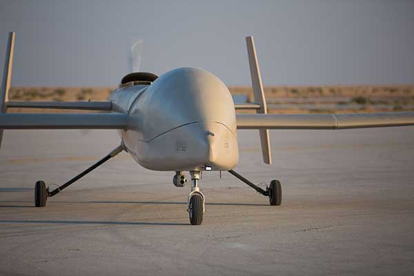
Photo: UAVOS

Photo: UAVOS

UAVOS company is collaborating with King Abdulaziz City for Science and Technology (KACST), Saudi Arabia, on scientific research and development of a new Flight Control System (FCS). The FCS is designed to fit and leverage multi-mission, multi-domain UAV platforms.

Together, the research and development (R&D) partners have created a Saker-1B Medium Altitude Long Endurance (MALE) UAS (unmanned aerial system). The specifications of the UAV system has been confirmed by more than 500 hours of day and night test missions under various weather conditions.

A total of 1,000 hours of take-off and landing test missions were successfully performed, with the long-endurance flights lasting up to 19 hours. The UAV is equipped with a satellite communication data link for beyond-visual-line-of-sight (BVLOS) operation.

Watch the Saker-1B in action:

UAVOS and KACST have been jointly developing Flight Control System capability for UAS for 10 years. R&D partners have completed performing the flight tests of their UAS in Saudi Arabia to verify easy and fully autonomous online and offline operation of the unmanned aircraft from takeoff to landing.

These test missions followed various other successful operational exercises performed in the last few months. The Saker-1B MALE UAS has been proven to operate in harsh desert with long-endurance, high-altitude and high-speed flights. High performance of satellite data link for command and control was demonstrated.

Due to availability of the current UAVOS autopilot technology, the UAS received sustainability to jamming attacks and advanced data security.

The Saker-1B performed a series of heavy weight landing tests with the maximum weight (MTOW) 2,500 pounds (1,100 kilograms). A number of different payloads were tested in surveillance experimental missions to confirm overall system performance and its readiness for real applications.

The UAS uses a direct radio link when flying within line of sight, switching seamlessly to a satellite link when flying BVLOS.

The Saker-1B MALE is an advanced unmanned aerial system with fully autonomous operation capability. It is equipped with automatic taxi-takeoff and landing systems, satellite communication for extended range, and fully redundant avionics.

The UAV is designed to operate in harsh environments and is adapted to perform in an extremely hostile, dry and dusty ambient air. The UAS is capable of flying for more than 19 hours at an altitude of up to 16,500 feet (5000 м) with a range 1600 miles (2600 km).

“We’re excited to work with KACST, a world-class organization in science and technology, fostering innovation and promoting a knowledge-based society in the Kingdom of Saudi Arabia,” said UAVOS CEO and Lead Developer Aliaksei Stratsilatau. “Our ultimate goal of the scientific research and development partnership is to make UAV technologies, which can turn vision into the UAV of tomorrow. For 10 years in partnering with KACST, we hold to a singular and enduring mission: to make breakthrough technologies for the unmanned system industry,”Aliaksei Stratsilatau added.

Publicerad den Lämna en kommentar

US Air Force equips U-2 pilots with Garmin GPS watch

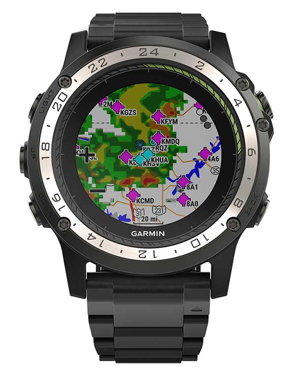
Weather radar overlay feature within Garmin D2 Charlie. (Photo: Garmin)

Weather radar overlay feature within Garmin D2 Charlie. (Photo: Garmin)

The U.S. Air Force is expected to take delivery of more than 100 D2 Charlie aviator watches for the specialized pilot group that flies the Lockheed U-2 aircraft.

Garmin’s D2 Charlie aviator watch has been selected by the United States Air Force (USAF) for use by the pilots of the Lockheed U-2 aircraft.

The high-sensitivity WAAS GPS-enabled D2 Charlie aviator watch incorporates global navigation capability, rich and colorful moving maps and more, providing pilots in the USAF with an exclusive, back-up navigation timepiece in the cockpit.

The watch receives both GPS and GLONASS signals.

U-2 for reconnaissance. The U-2 is a versatile, ultra-high-altitude reconnaissance aircraft used for intelligence gathering, research and communication purposes.

The U-2 provides high-altitude, all-weather surveillance and reconnaissance, day or night, in direct support of U.S. and allied forces. It delivers critical imagery and signals intelligence to decision makers throughout all phases of conflict, including peacetime indications and warnings, low-intensity conflict, and large-scale hostilities.

100 watches ordered. The USAF is expected to take delivery of more than 100 D2 Charlie aviator watches for the specialized pilot group that flies the Lockheed U-2 aircraft. With a service ceiling of 70,000 feet, the D2 Charlie will provide unique benefits such as barometric-based O2 alerting and GPS-specific features including track, distance to the next waypoint, estimated time enroute and more.

“Garmin is honored to have been selected by the United States Air Force to equip the men and women who fly one of the most iconic aircraft in the history of aviation,” said Carl Wolf, Garmin vice president of aviation sales and marketing. “The D2 Charlie aviator watch will be an integral and functional part of the U-2 pilot’s toolkit.”

A U.S. Air Force U-2 Dragon Lady flies a training mission. (Photo: U.S. Air Force photo by Master Sgt. Rose Reynolds):

A U.S. Air Force U-2 Dragon Lady flies a training mission. (Photo: U.S. Air Force photo by Master Sgt. Rose Reynolds):

Designed with pilots of varying backgrounds and missions, the D2 Charlie aviator watch features a colorful, dynamic moving map which depicts airports, navaids, roads, bodies of water, cities and more, offering greater situational awareness.

When the D2 Charlie is paired with Garmin Connect on a connected mobile device, pilots can view weather radar on top of the map display relative to flight plan information.

Pilots can also display estimated time enroute (ETE), universal coordinated time (UTC) or other pilot-selectable data fields overtop the map so it’s easy to monitor the progress of a flight and view pertinent flight information simultaneously.

The Direct-to feature within D2 Charlie watch. (Photo: Garmin)

The Direct-to feature within D2 Charlie watch. (Photo: Garmin)

Standalone navigator. An advanced, standalone navigator, the D2 Charlie aviator watch incorporates exclusive navigation functions and capabilities, including dedicated direct-to and nearest buttons along the side of the bezel that allow the user to easily build or modify flight plans.

Airport information pages display communication frequencies, runway information (including dimensions and surface type), weather data and more for a specified airport.

The flight log page allows pilots to conveniently reference recent flights at their wrist, displaying date, flight duration, total distance and more of a particular flight. Additionally, improved flight planning capabilities include the option to add multiple waypoints within a single flight plan and the ability to navigate direct to any waypoint in a flight plan.

Heart-rate monitor. The D2 Charlie is made of premium materials, including a sapphire scratch-resistant crystal lens and a diamond-like carbon-coated titanium bezel for improved durability. A sunlight-readable, high-resolution color display with an LED backlight on the watch face allows pilots to view data in most lighting conditions in the cockpit.

The D2 Charlie offers up to 20 hours of battery life in GPS mode and up to 12 days in smartwatch mode.

Garmin Elevate wrist heart rate technology allows pilots to measure heart rate 24/7 alongside daily activity tracking. The D2 Charlie aviator watch also comes preloaded with a full multisport toolset for running, golfing, cycling, swimming, skiing and more. Water rated to 100 meters, it can also withstand swimming and other water activities. When paired with a compatible smartphone, customers can also view phone calls, text and email smart notifications at their wrist.

Publicerad den Lämna en kommentar

IEEE/ION PLANS Conference canceled due to COVID-19 concerns

Logo: IONThe IEEE/ION PLANS Conference has been canceled. The conference — officially the IEEE/ION Position Location and Navigation Symposium (PLANS) — was scheduled to take place April 20-23 in Portland, Oregon.

“After careful consideration, the ION Executive Committee, in cooperation with the IEEE/ION PLANS program committee, made the decision this afternoon to cancel,” said  ION Executive Director Lisa Beaty in an email sent March 12.

The Institute of Navigation’s (ION’s) official position has been posted here.

The ION National Office has notified PLANS authors, exhibitors and vendors and provided each with additional information pertaining to their particular relationship or circumstance.

“The ION Executive Committee will be discussing additional follow-up considerations later this month,” Beaty said.

Publicerad den Lämna en kommentar

NASA Langley opens registration for SAND Challenge

Logo: NASA Langley SAND Challenge

NASA Langley opened registration for its Safeguard with Autonomous Navigation Demonstration (SAND) Challenge, which will be held May 2020 in Hampton, Virginia. According to NASA Langley, the SAND Challenge will be an opportunity for small businesses to compete in an autonomous unmanned aerial vehicle (UAV) competition.

The challenge will address some of the safety critical risks associated with flying UAVs in the national airspace system.

NASA released the competition scenario, which reads:
Hampton, Virginia, was hit by a large and devastating hurricane. The effect of the hurricane was to flood much of the area, knock down trees, damage houses/buildings, disrupt power lines and cause some injuries to residents. As part of the recovery effort, crews are working to locate incapacitated people, assess the damage to neighborhoods, look for downed power lines and determine the extend of the remaining flooding. To meet those objectives, both manned and unmanned aircraft are being leveraged to expedite the response. The Concept of Operations employed assumes UAS will remain within a specific volume of airspace to ensure the safety of unmanned aircraft operating in the vicinity, as well as the safety of first responders that are working in adjacent zones. UAS are assigned to specific areas to perform search and surveillance efforts. Safeguard provides range containment for vehicles independent of the UAS operator’s ability to monitor the vehicle, either by direct line of sight or through telemetered data. Its use for SAND is similar to beyond visual line of sight applications.

NASA Langley’s patented Safeguard technology will be used to help small business competitors mitigate such risks while they complete a set of complex mission profiles. For this competition, it will be configured to warn competitors (and auto-pilots) of impending excursions (or violations) while also objectively measuring performance with respect to the rules of the competition. The challenge will follow the Federal Aviation Administration Part 107 Regulation Small Unmanned Aircraft Regulations.

The winning team will receive a $20,000 grand prize. Register for the competition here.

Publicerad den Lämna en kommentar

Wingtra adds enhanced data capability with Trimble Business Center

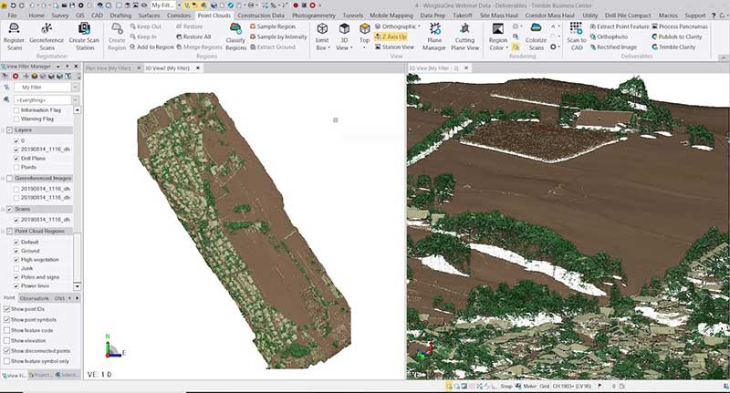
Photo: Wingtra

Photo: Wingtra

With Wingtra’s latest software release, surveyors and geospatial professionals can now directly import WingtraOne drone data into the Trimble Business Center (TBC).

According to Wingtra, the new integration seamlessly combines WingtraOne high-accuracy drone data within TBC, optimizing drone mapping workflows for survey and construction projects within a single software platform.

The integration allows users to drag and drop data into the software suite. Automated point cloud tools, such as classification and feature extraction, can then be used to quickly generate surface models, topographic plans and as-built deliverables.

Photo: Wingtra

Photo: Wingtra

“It’s a solid step forward to enable our data to work smoothly with Trimble Business Center,” said Francois Gervaix, Wingtra’s geospatial expert. “TBC is a reference software in the industry, because of its success as a data hub for construction and geospatial workflows. Optimizing the workflow lets TBC users smoothly integrate data from the fastest drone data capture platform on the market — WingtraOne.”

This latest Wingtra software release that introduced JobXML (TBC file format) compatibility also brought various other product updates. Namely, high-altitude flight capabilities, longer flight times and more intuitive battery level readings in-flight, Wingtra added.

Publicerad den Lämna en kommentar

Lunchseminarium 2020

Lantmäteriet erbjuder under 2020 fyra webbsända lunchseminarier där du bland annat får information om arbetet med att uppdatera den Nationella geodatastrategin och status i de aktiviteter som pågår i Geodatarådets handlingsplan.

Just nu pågår arbete med att uppdatera den Nationella geodatastrategin för 2021-2025. Strategin ska omfatta hur geodata kan bidra till att lösa viktiga samhällsutmaningar samtidigt som skyddet av Sveriges säkerhet och informationssäkerhet värnas. Strategin ska särskilt inriktas mot att bidra till det svenska genomförandet av Agenda 2030. Uppdraget ska redovisas till regeringen senast den 30 augusti 2020.
Torsdag den 12 mars, bjöd Lantmäteriet in till årets första lunchseminarium, för att informera om arbetet med strategin, Geodatarådets handlingsplan och status Inspire. Ta del av inspelningen här.

Nyhet från geodata.se, orginal inlägg