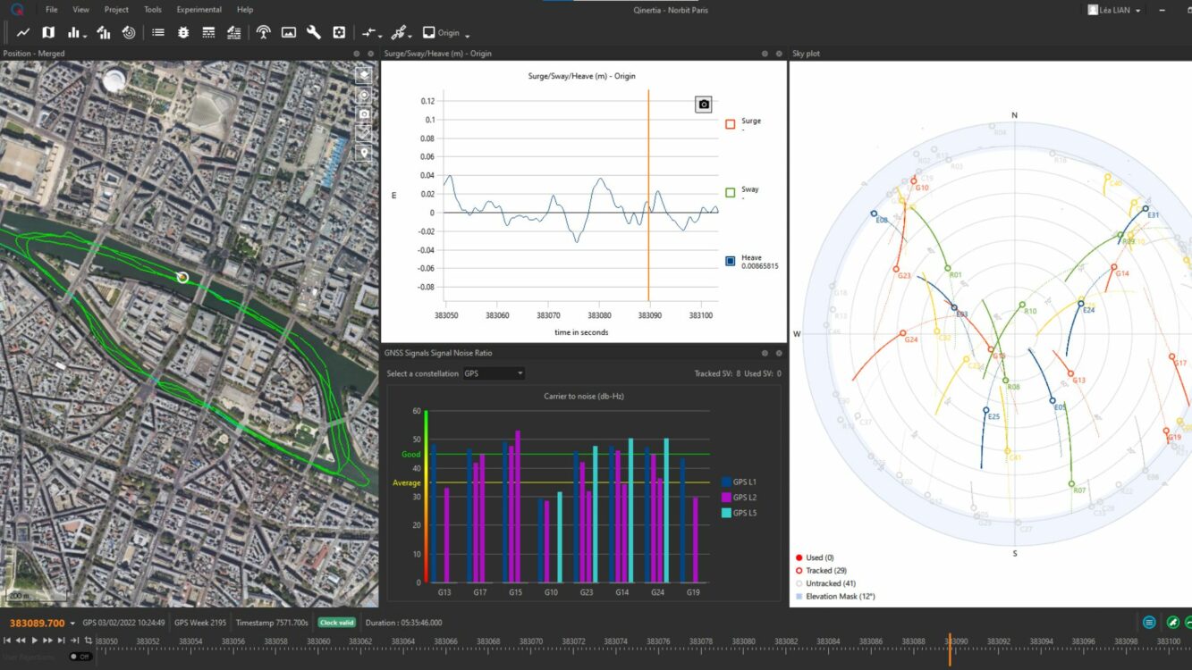
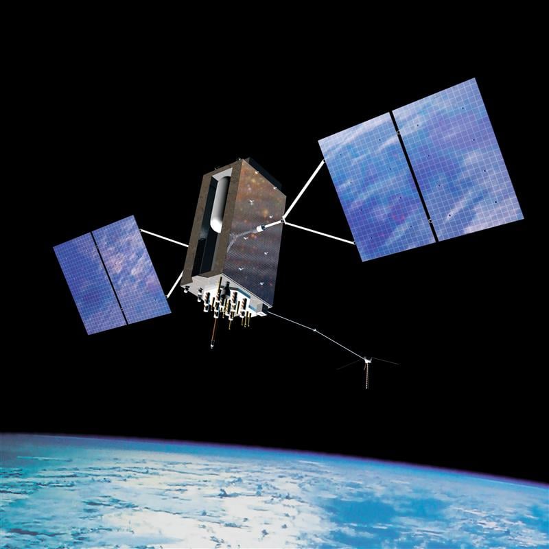
Publicerad den Lämna en kommentar

Tallysman releases new L-Band GNSS antenna

Image: Tallysman

Image: Tallysman

Tallysman Wireless has released the ARM972XF triple-band plus L-Band GNSS antenna.

The ARM972XF uses Tallysman’s accutenna technology providing GPS/QZSS L1/L2/L5, GLONASS-G1/G2/G3, Galileo E1/E5a/E5b, and BeiDou B1/B2a/B2b + L-Band coverage. The technology is designed for precision triple-frequency positioning where light weight and a low profile are required.
Tallysman’s ARM972XF is a small and lightweight housed triple-band precision mini ARINC GNSS antenna. It has an average phase center variation of less than 10 mm for all frequencies and overall azimuths and elevation angles. Additionally, both models are available with components qualified for low Earth orbit (LEO).

Housed in a weatherproof (IP67) enclosure, the ARM972XF is available in four versions. Model ARM972XF-1 (ARM972XF-1-S for LEO space-qualified components) has an integrated 100 mm ground plane, while model ARM972XF-2 (ARM972XF-2-S for LEO space-qualified components) is 83 mm in diameter.

The antenna also includes Tallysman’s eXtended filtering (XF) technology, designed to mitigate GNSS interference.

Publicerad den Lämna en kommentar

OxTS introduces INS for land and air applications

Image: OxTS

Image: OxTS

OxTS has released the xRED3000, its lightest and smallest inertial navigation system (INS) suitable for land- and air-based applications.

Combining two survey-grade GNSS receivers and OxTS’ latest IMU10 inertial technology, the xRED3000 is designed to be the GNSS/INS component for products requiring accurate localization, even in harsh environments.

The xRED3000 uses OxTS lidar inertial odometry (LIO), which takes data from a lidar in post-processing to reduce IMU drift and improve accuracy in areas with poor or no GNSS signal such as urban canyons. The technology also provides a position accuracy of 0.5 m, even after 60 seconds of no GNSS signal.

The INS is compatible with OxTS Georeferencer, a post-processing and calibration software that aims to improve the accuracy and clarity of user’s pointcloud data. It warms up to specification in three minutes, even with low-dynamic movement, increasing flight time for aerial applications and reducing the space needed for land-based warmups.

Publicerad den Lämna en kommentar

Syntony launches CRPA GNSS receiver

Image: Syntony GNSS

Image: Syntony GNSS

Syntony GNSS has released CERBER, a GNSS receiver embedded in a CRPA solution.

A classic CRPA system consists of embedded GNSS antennas and antijamming treatments. However, CERBER relies on the tight integration of a CRPA treatment (with a 4-array antenna) and the embedded GNSS receiver.

The estimation of GNSS direction of arrival (DoA) is enabled and allows the receiver to check whether those DoA estimations are compatible with GNSS constellations or originate from very few directions. Therefore, users will be able to detect and locate spoofing devices or receivers instantly.
The receivers are also able to constantly recalibrate the chains of reception based on the DoA and GNSS signals.

CERBER’s embedded approach also enables a 6dB power gain in satellites’ directions, the continuity of GNSS signals’ phase when the space-time adaptive processing (STAP) filter is updated, the absence of additional noise that a GNSS receiver would imply with the re-generation and re-digitalization of RF signals and an improved rejection performance when compared to a classic CRPA + independent GNSS receiver solution.
This technology is designed for the protection and the surveillance of civil critical infrastructures, including Galileo’s and EGNOS’ ground segments, airports or any infrastructure requiring precise and resilient GNSS timing.

Publicerad den Lämna en kommentar

Hexagon expands TerraStar-X GNSS correction service to South Korea

Image: metamorworks/iStock/Getty Images Plus/Getty Images

Image: metamorworks/iStock/Getty Images Plus/Getty Images

Hexagon’s Autonomy & Positioning division and Munhwa Broadcasting Corporation (MBC) have partnered to bring precise positioning to South Korea through the TerraStar-X Enterprise Correction Service. The hardware-agnostic correction service provides instant convergence and lane-level accuracy in automotive, mobile and autonomous applications.

As a leader in real-time kinematic (RTK) positioning across South Korea, MBC’s atmospheric data enhances the redundancy of Hexagon’s fast converging and reliable precise point positioning (PPP) network across the country. Through this collaboration, the TerraStar-X Enterprise service is now supported in testbeds across South Korea, China, Japan, Europe, and North America to accelerate development for advanced driver assistance systems, safety-critical applications, micromobility, industrial and smartphone applications.

“With TerraStar-X Enterprise Correction Services now available across autonomous and consumer market applications, developers can design once and then deploy that design at scale worldwide,” said Paul Verlaine Gakne, positioning services product manager at Hexagon’s Autonomy & Positioning division. “TerraStar-X Enterprise is designed to be as flexible as possible for large-scale testing and deployment.”

Publicerad den Lämna en kommentar

Topcon joins Septentrio’s Agnostic Corrections Partner Program

Image: Septentrio

Image: Septentrio

Topcon Positioning Systems is joining Septentrio’s Agnostic Corrections Partner Program. This program was launched earlier this year to facilitate the use of Septentrio receivers with various high-accuracy services, offering integrators the flexibility to choose the most suitable correction service for their specific application.

Topcon’s Topnet Live is a real-time GNSS corrections service that delivers high-quality centimeter-level real-time kinematic (RTK) corrections data with a broad worldwide network coverage and a variety of subscription options.

“This collaboration with Topcon enables us to bring more high-quality corrections options to our customers,” Gustavo Lopez, senior market access manager at Septentrio said. “Septentrio’s robust GNSS receivers combined with Topcon’s reputable infrastructure creates a powerful synergy that offers high precision and reliability to industrial sectors, including construction and mining, while also catering to emerging applications such as robotics and automation.”

Publicerad den Lämna en kommentar

ComNav Technology and Dominican Republic forge advanced CORS network

ComNav Technology has collaborated with FUNDCORSRD, a non-profit institution, to establish a comprehensive network of continuous reference stations (CORS) across the Dominican Republic for conducting topographic surveys.

As a result of this collaborative effort, there are now 32 CORS stations spread throughout the Dominican Republic that are fully implemented with the SinoGNSS CORS solution from ComNav.

ComNav Technology’s choice of equipment for this project included the M300 Pro GNSS receivers and AT600 choke ring antennas for the CORS reference stations.

The M300 Pro features robust satellite tracking capabilities, supporting multiple satellite constellations such as GPS, GLONASS, BeiDou, Galileo, SBAS, L-band, and QZSS. It also comes equipped with a built-in web server, interfaces for external devices, a user-friendly front panel display, optical fiber interface, and a secure TF-card with password protection.

The AT600 high-performance choke ring antenna features high gain, accuracy, and reliability, along with full-constellation compatibility.

Publicerad den Lämna en kommentar

SBG Systems unveils Qinertia 4

Image: SBG Systems

Image: SBG Systems

SBG Systems will release the newest version of its Qintertia technology, Qinertia 4, on November 7, 2023. This version introduces several innovative features that provide users with a complete solution for precise trajectory and motion analysis.

Qinertia is a post-processing software delivering better precision and reliability compared to RTK systems. Qinertia 4 has an enhanced Geodesy engine to boasts an extensive selection of preconfigured coordinate reference systems (CRS) and transformations, making it a versatile solution in applications that use diverse geodetic data, including land surveying, hydrography, airborne surveys, construction and more.

To tackle the challenges of variable ionospheric activity, the new technology uses Ionoshield PPK mode. This feature compensates for ionospheric conditions and baseline distances, allowing users to perform post-processing kinematics (PPK) even for long baselines or harsh ionospheric conditions.

Another addition to Qinertia 4 is extended continuously operating reference stations (CORS) network support. This feature offers users a vast network of 5000 SmartNet for reliable GNSS data processing.

Qinertia has more than 10,000 bases in 164 countries. This global coverage ensures that Qinertia remains a reliable and efficient solution, regardless of geographic location. In addition, users can import their own base station data and verify its position integrity with precise point positioning (PPP).

For data that cannot be processed using PPK, Qinertia 4 offers an alternative solution with its new tightly coupled PPP algorithm. This new processing mode, available for all users with active Qinertia maintenance, provides post-processing anywhere in the world without a base station, with a horizontal accuracy of 4cm and a vertical accuracy of 8cm.

Qinertia’s new functionalities will be demonstrated live at Intergeo 2023 in Berlin.

Publicerad den Lämna en kommentar

Inside the box: GPS and relativity

Image: GPS.gov

Image: GPS.gov

Clocks are at the heart of GPS. Advances in space-qualified atomic clocks that kept time to within 10 nanoseconds over a day were a key development that made GPS possible. It turns out that GPS must account for both special relativity and general relativity to deliver position at 1-meter level and time at 100-nanosecond level to its users. We’ll use these round numbers as user expectations from GPS.

In the simple engineering analysis below, we consider the problems that would have arisen if the engineers had ignored relativity in their design of GPS. The issues related to positioning and time transfer are distinct, so we treat them separately.

GPS is basically a bunch of synchronized, near-perfect clocks in orbit

It’s a mantra worth repeating: To measure ranges to GPS satellites with meter-level accuracy, the clocks on the satellites must keep time with nanosecond-level accuracy.

The clocks aboard GPS satellites are extraordinarily stable, typically to one part in 1013 over a day, which is another way saying that they could gain or lose on average 10-8 seconds, or 10 nanoseconds, over 105 seconds, which is roughly the length of a day. It’s a simple calculation. Suppose you measure a time interval of length with an oscillator advertised to have frequency by counting its periods of oscillation. If the actual frequency is (f + Δf ), you’d measure the time interval as (T + Δt). It is easily shown that:

The fractional frequency stability (f / Δf ) is a key parameter. For an oscillator with stability (f / Δf ) of 10-13  over a day, as noted above, we can limit to 10 nanoseconds on average with data uploads to satellites once a day to re-sync the clocks. An error of 10 nano-seconds in time amounts to an error of about 3 meters in range computation and, speaking roughly, an error of about 3 meters in the position computed by the receiver. We can live with that.

Gravitational and motional effects on GPS clocks

Our previous calculation of the timekeeping error of a satellite clock would have been fine had we not overlooked an important fact: We pretended as though the clocks were at rest on Earth at mean sea level. So, let’s see what relativity has to say about clocks in 20,000-kilometer-high circular orbits around Earth. The satellite orbits are not perfectly circular, or identical, but for now let’s pretend that they are. We call that modeling. The clocks would move at a rate of about 4 kilometers per second and exist in an environment where Earth’s gravity is only about one-fourth that at sea level.

According to the theory of special relativity, a moving clock ticks more slowly when compared with one that’s stationary at sea level. A clock aboard a GPS satellite will lose about 7 microseconds per day. That is three orders of magnitude larger than our budget for satellite clock error discussed earlier, therefore we can’t simply ignore it.

According to the theory of general relativity, on the other hand, a clock in a weaker gravitational field will tick faster than one that’s stationary at sea level. Apparently, gravity weighs down time, too. A clock aboard a GPS satellite in a medium Earth orbit will gain about 45 microseconds per day over a clock that’s at sea level on the earth.

The net effect: A GPS satellite clock will gain about 38 microseconds per day over a clock at rest at mean sea level. This effect is secular, meaning the time offset will grow from day to day.

So, you ask: Can you show me how you came up with these numbers, 7 micro-seconds and 45 microseconds? No, but I can point you to the references listed below and I can come close using simple mathematical models: (i) Earth’s gravitational potential is complicated and to simplify things we model Earth as homogeneous in composition and spherical in shape with a radius (rE) of 6,400 kilometers; (ii) aGPS satellite orbit is a circle with radius 4 rE; and (iii) the satellites move at the rate of 4 kilometers/second. We saved ourselves a lot of trouble by agreeing on this simple model.

sidebar

sidebar

The calculation of the fractional frequency stability (f / Δf ) due to the relativistic effects is now easy and given in the sidebar. The answers are only approximate, but surprisingly close to the numbers cited above. That’s the beauty of good models. To calculate time gained or lost over a day, multiply by the length of a day in seconds.

As an interesting aside, note that the effects predicted by special relativity and general relativity cancel each other for clocks located at sea level anywhere on Earth. Consider two clocks, one located at the North or South Pole, and the other at the equator. The clock at the equator would tick slower because of its relative speed due to Earth’s spin, but faster because of its greater distance from Earth’s center of mass (about 22 kilometers) due to Earth’s flattening. Because Earth’s spin rate determines its shape, the two effects are not independent, and it’s no coincidence that they cancel exactly.

What if GPS forgot about relativity?

What would have happened if the engineers responsible for designing GPS had disregarded relativity? If the GPS satellites were in fact in identical, circular or-bits, their clocks would have shown a puzzling, but identical, behavior of gaining time over clocks of the Control Segment on Earth at a steady rate, about 38 microseconds over a day, the combined effect of special and general relativity.

What would that do to range measurements? A GPS receiver would have meas-ured the ranges to all satellites in view as too short by a common amount (up to about 11 kilometers between daily uploads of clock corrections). However, GPS receivers don’t measure ranges. To measure ranges, the receiver clock would have to be synchronized with the satellite clocks, an onerous requirement. The receivers use inexpensive clocks that drift and have frequency stability no bet-ter than . The receivers measure pseudoranges, i.e., ranges with a common bias on account of the receiver clock offset relative to GPS Time. This bias is es-timated by the receiver, along with its three-dimensional position. The price of an inexpensive receiver clock is that we now have four parameters to estimate and need pseudorange measurements from four satellites.

So, what would that do to positioning? The answer is that the common bias introduced by the relativistic effects would get lumped with the typically much larger bias introduced by the offset in the receiver clock. The position estimate would be unaffected.

Now, what about time from GPS? A GPS receiver used for timing is typically stationary with its antenna location carefully surveyed. In principle, a single pseu-dorange measurement can sync it to GPS Time (and UTC). So, if the relativistic effects had been ignored, the timing accuracy would have suffered to the ex-tent of 38 microseconds per day between updates of the clock parameters. That’s a deal-breaker, considering that we expect 100-nanosecond accuracy.

The relativistic effects discussed so far can be compensated for easily by setting the frequency of the satellite clocks lower (by 0.0045674 hertz) in what’s called “factory offset”: The frequency of a satellite clock is set to 10.22999999543 megahertz so that it will tick in orbit at the same rate as a 10.23-megahertz atomic standard at sea level on Earth. What an ingenious solution!

This factory offset would have accounted for the relativistic effects completely if the GPS satellite orbits were perfectly circular and identical. They are not. You can’t control an orbit perfectly.

So, what about eccentric orbits?

Yes, that’s a complication.

Each orbit is distinct and slightly elliptical. A consequence of this is that the sat-ellite speed is not constant (due to Kepler’s second law): the farther away a sat-ellite gets from Earth in its elliptical orbit, the slower it moves; and the farther away the satellite, the lower is the gravity field. That means the clocks in differ-ent satellites are speeding up and slowing down at different times and at differ-ent rates. The effect for each clock is periodic and quasi-sinusoidal. Averaging the effect over an orbit, we get zero.

For a satellite in an orbit with an eccentricity of 0.02, the net effect is that a clock can be ahead or behind by as much as 45 nanoseconds. The corresponding range error would amount to ± 15 meters. This effect must be accounted for specifically for each orbit. It would require serious bookkeeping on where the satellite has been in its elliptical orbit since the last data upload to sync its clock. It’s a messy business but can be simplified. We’d leave it at that. See ICD-GPS-200C, Section 20.3.3.3.3.1, if you want to see how it is implemented in your GPS receiver.

There is more to relativity than the special theory and general theory. There is the Sagnac effect associated with our rotating reference frames attached to Earth, in which we’d like to determine a position. The principle of constancy of the speed of light cannot be applied in a rotating reference frame, where the paths of the radio rays are not straight lines, but spirals. (Receivers at rest on Earth are moving quite rapidly: 465 meters per second at the equator.) There is also the Shapiro delay associated with the slowing of electromagnetic waves as they near Earth, which amounts to a fraction of a nanosecond. See the refer-ences for more on these topics.

Final thought: Could Einstein have imagined one hundred years ago that a bil-lion people would unknowingly account for the effects of his esoteric theory in their everyday activities?


Refrences 

  1. Ashby (1993), “Relativity and GPS,” Innovation column in GPS World
  2. Ashby (2003), Relativity in the Global Positioning System. Living Reviews in Relativity https://link.springer.com/article/10.12942/lrr-2003-1
  3. https://www.gps.gov/technical/icwg/ICD-GPS-200C.pdf
Publicerad den Lämna en kommentar

INTERGEO 2023 is fast approaching

INTERGEO 2023 will take place Oct. 10-12, in Berlin, Germany, and GPS World staff will be in attendance. The main topics of the annual conference include Earth observation, maritime solutions, unmanned systems and building information modeling (BIM).

The three-day event will also cover the topics of GIS and artificial intelligence, metaverse and cloud applications, Earth observation and environmental monitoring, smart city, infrastructure BIM, digital twins, satellite services COPERNICUS and Galileo, 4D geodata, 3D cadastre, smart mapping applications, Geobasis 2030 and 3D point clouds illuminated.

In addition to international keynote speakers, the conference will focus on expert exchange and live experiences with panel discussions and networking events.

While GPS World will not have a booth, attendees can catch Matteo Luccio, the magazine’s editor-in-chief, on the show floor.

The INTERGEO conference program can be found here.

Publicerad den Lämna en kommentar

Virtual Surveyor launches smart UAV survey software

Image: Virtual Surveyor

Image: Virtual Surveyor

Virtual Surveyor has added drone photogrammetry capabilities to its Virtual Surveyor smart UAV surveying software. The new Terrain Creator app photogrammetrically processes UAV images to generate survey-grade terrains which then transfer into the traditional Virtual Surveyor workspace.

The Virtual Surveyor software is now two desk apps in one subscription package, creating a seamless end-to-end UAV survey workflow, said Tom Op‘t Eyndt, Virtual Surveyor’s CEO.

Terrain Creator aims to simplify the aerial photogrammetry process by offering a visual and intuitive application to produce an orthomosaic and digital surface model (DSM) from drone photos, the company said.

Virtual Surveyor software was originally developed to bridge the gap between UAV photogrammetric processing applications and engineering design packages.

Prior to this new release, users had to rely on third-party software to generate elevation models and an orthomosaic on which they could work with the Virtual Surveyor toolset. Now, users can derive the 3D topographic information necessary for construction, surface mining and excavation projects in one package.

Once the survey-grade terrains flow from the Terrain Creator into the Virtual Surveyor desktop app, users can access an interactive virtual environment and robust toolsets to generate CAD models, create cut-and-fill maps and calculations, or calculate volume reports.

Users currently subscribed to Virtual Surveyor Ridge and Peak editions will see their software updated automatically with Terrain Creator. A flexible licensing setup will allow two users within a subscribing organization to use the Terrain Creator and Virtual Surveyor applications simultaneously from different computers.