Publicerad den Lämna en kommentar

Are we ready for autonomous planes?

Headshot: Tracy Cozzens

Tracy Cozzens

Our cover story this issue is all about autonomous vehicles. Retirees — not usually considered early adopters of technology — are trusting autonomous vehicles to ferry them from point to point using the technology our industry can offer.

We have also used a lot of magazine space to discuss unmanned aerial vehicles, or drones, and shown how they are taking on a lot of tasks formerly done by manned pilots or workers, such as aerial mapping or factory inspections.

So is the idea of an autonomous plane such a stretch?

At June’s Paris Air Show, Christian Scherer, chief commercial officer for Airbus, told the Associated Press that his company already has the technology to fly passenger planes without pilots.

Scherer also said in the AP interview that Airbus hopes to be selling hybrid or electric passenger jets by around 2035.

Airbus already has “the technology for autonomous flying.”

But having the tech is one thing. Winning over regulators and potential travelers is quite another.

“When can we introduce it in large commercial aircraft? That is a matter we are discussing with regulators and customers, but technology-wise, we don’t see a hurdle,” Scherer said.

In fact, in a new study, seven out of 10 people say they would be willing to travel in an unpiloted plane at some point in their lifetime. The survey was conducted by U.S. software firm Ansys, which is working to provide digital replicas of how planes and cars react in different situations.

Passengers would be more willing to embrace automation if firms could show that a computer would react in the best and quickest way if anything unexpected happens.

But are we there yet? Michael Wiggins, the chairman of the aeronautical science department at Embry-Riddle Aeronautical University in Florida, addressed the autonomous-flight adoption question for the New York Times.

“From what I see, could it happen in the distant future? I think it probably could. Will it happen in the near future? I don’t think so,” Wiggins said. “Right now, any progress toward that area should be done very slowly, very measured and only after a bunch of research with results that suggest we should do that.”

Publicerad den Lämna en kommentar

Autonomous street sweeper relies on Unicore precision

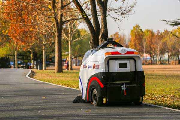
The sweeper Woxiaobai has been in service for a year. (Photo: Unicore)

The sweeper Woxiaobai has been in service for a year. (Photo: Unicore)

Fall is a beautiful time of year. But when the leaves drop, it means a lot of sweeping for most of us. Not so for the 200 campuses and parks in China using IdriverPlus’ WO series of unmanned sweepers.

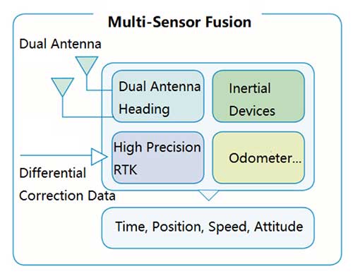
High-precision GNSS positioning plays an important role in making the autonomous units possible, providing real-time high-precision position, speed and time information.

The sweeper in Beijing’s Haidian Park. (Photo: Unicore)

The sweeper in Beijing’s Haidian Park. (Photo: Unicore)

Unicore’s high-precision GNSS technology and their products’ high reliability have enabled IdriverPlus’ unmanned sweepers and logistics vehicles — China’s first mass-produced products in intelligent driving. In January, IdriverPlus received the green light to test self-driving cars in Beijing.

Diagram: Unicore

Diagram: Unicore

Sweepers and logistics vehicles are not only used in open-sky areas, but also in complex environments shadowed by buildings or trees or experience multipath. These areas include school campuses, factory and science parks, and community squares.

Complex environments result in different GNSS availability, reliability and convergence. In autonomous driving, the inputs the vehicle receives from GNSS and other sensors must be accurate and reliable.

A customer removes her express package from the Wobida logistics vehicle. (Photo: Unicore)

A customer removes her express package from the Wobida logistics vehicle. (Photo: Unicore)

The UM482 module used by the IdriverPlus is characterized by dual antennas, compact dimensions, high performance and low cost, providing anti-jamming performance.

Integrated with on-board MEMS and Unicore’s U-Fusion combination technology, the UM482 can effectively solve the disruption of positioning results caused by the loss of satellite signal, and further optimize the continuity and reliability of positioning and heading outputs in complex environments such as city canyons, buildings and tunnels.


See also Age of acceptance: Retirement communities embrace driverless shuttles.

Publicerad den Lämna en kommentar

Age of acceptance: Retirement communities embrace driverless shuttles

Two companies have integrated GPS/PNT tech into a growing autonomous vehicle market: driverless shuttles for retirement communities. Powering the service, a cloud-based GNSS corrections system delivers centimeter-level accuracy without deploying and maintaining a GNSS network. This leading-edge application targets autonomy at scale and enables high-precision positioning for mass-market automotive and autonomous vehicle applications.

Photo: Voyage

Photo: Voyage

For many seniors, retirement communities offer the best of both worlds: the freedom to live in their own homes and access to immediate assistance when they need it.

Driverless cars are an option several retirement communities have embraced to better serve residents who no longer have the ability or desire to drive, but want to retain the ability to come and go as they please.

“Autonomous vehicles are a great fit for any community where the environment is well-understood, less complex than dense urban areas, and the transportation demand is high,” said Justin Erlich, vice president of strategy, policy and legal for Palo Alto, California-based Voyage, a company that employs existing technology to develop fleets of autonomous vehicles. “Retirement communities satisfy all of these characteristics.”

Serving Seniors

Voyage deployed driverless shuttles to serve 130,000 retirees at The Villages, a massive retirement community encompassing more than 50 square miles in Sumter County, Florida.

“The community’s residents enjoy an extremely active lifestyle, but often face challenges getting around,” Erlich said. “Autonomous vehicles are perfectly suited to meet this demand.”

The six vehicles in the fleet stay within the confines of the retirement community, where all roads have been precisely mapped, speed limits are lower and traffic patterns are more clearly defined than in a typical city. The vehicles travel over a network of roads that span 750 miles.


THE VILLAGES

Location: Sumter County, Florida
Area: 50 square miles
Road span: 750 miles
Number of retiree residents: More than 130,000
Number of Voyage autonomous vehicles: 6


To request one of Voyage’s autonomous vehicles, a resident can summon the shuttle on-demand with a smartphone. Voyage is working with residents on the possibility of using other shuttle-request options, including text messages, phone calls and well-marked pickup zones in crowded downtown areas, Erlich said.

All passengers ride with Voyage safety drivers in the front seat. The drivers take note of any “events” during rides so Voyage can investigate how to improve the riding experience.

Photo: Voyage

Photo: Voyage

Eventually, residents will be the only passengers in the vehicles. If they need assistance during a ride, they will be able to communicate with remotely located Voyage employees, Erlich said.

Testing and rolling out fleets of driverless vehicles in private communities like The Villages allows Voyage to develop and perfect the autonomous vehicle technology it uses. As a result, the company can deliver the service to new clients in mere months.

Voyage, which has been working on its autonomous technology for more than two years, uses daily customer feedback to constantly adjust to its technologies to better serve riders.

“Feedback collected during test drives is one of the biggest factors in shaping our technology roadmap,” Erlich said. “Driving data — collected across all sensors and traffic scenarios — is automatically processed each night, highlighting interesting ‘events’ for our engineering team to analyze and review.”

During Voyage’s beta test process at The Villages, residents applied to be part of the company’s Pioneer Program for early access to the autonomous vehicles and the ability to offer feedback early on. Riders who test the service complete scorecards after each trip to help improve the experience for all riders.


Europe Takes the Lead

(Tire photo: iStock.com / TANAPHONG)

(Tire photo: iStock.com / TANAPHONG)

Autonomous vehicle technology is taking off in Europe, shows a study published by the European Patent Office and conducted with the European Council for Automotive Research & Development. From 2011 to 2017, European patent applications related to automated driving increased 20 times faster than other technologies in recent years. The “Patents and self-driving vehicles” study reveals automated driving patent applications at the European Patent Office rose 330%, compared with 16% for all technologies during the same time.


“As one of the only self-driving car companies that are picking up actual passengers as a part of our Pioneer Program, we believe we can learn a lot from the feedback we hear from our initial Pioneer riders as we try to make this the best service for The Villages,” said Oliver Cameron, co-founder and CEO of Voyage. “We are excited to see so much interest from other residents to become a part of this program.”

When developing autonomous technology, safety is Voyage’s top priority, Erlich said. Every change to the hardware and software used undergoes a multi-stage validation process. Company engineers perform “on-desk” tests of every change using unit tests, functional tests and a driving simulation environment. Then, an operations team runs suites of real-world traffic and validation tests in a completely controlled environment at a closed-course testing facility in San Jose, California

“Voyage makes extensive use of simulation testing and closed-course validation before any of our vehicles are driven in our partner communities,” Erlich said. “All changes must pass these closed-course tests before making their way onto the roads of our partner communities.”

Vehicle design also ensures riders stay safe. “Our fleet vehicles have been designed with multiple levels of safety redundancies for braking, steering and power, and leverage an advanced diagnostics system to automatically detect anomalies and safely stop the vehicle,” he explained. “In addition, we have developed a remote teleoperations solution that allows the vehicle to request additional help when a driver is not physically in the vehicle.”
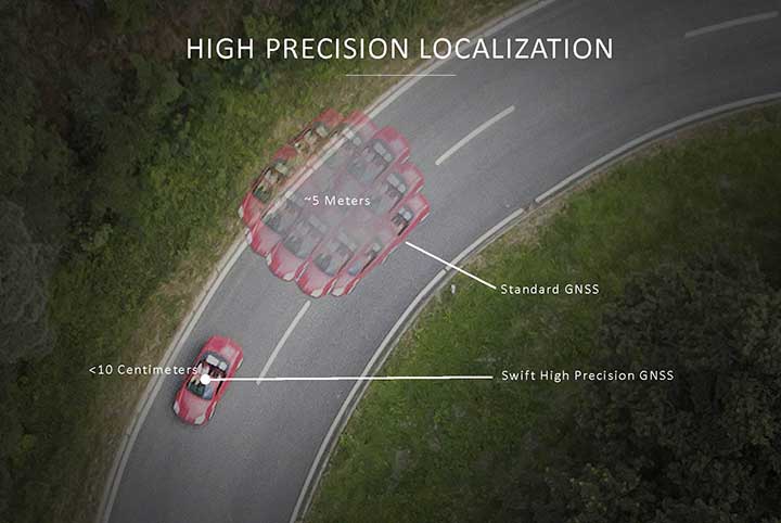
Skylark provides high-precision localization. (Image: Swift Navigation)

Skylark provides high-precision localization. (Image: Swift Navigation)

Making Autonomous Work

When building an autonomous system, localization — knowing exactly where you are in the world — is critical. Erlich said it’s often difficult to estimate your position within an accuracy of several feet when using more traditional GPS solutions.

“For autonomous driving, you need to be able to estimate within several centimeters,” he added.
Voyage uses Swift Navigation’s GNSS receivers and Skylark network as one of the primary inputs into its localization solution.

Swift Navigation is a San Francisco-based tech firm that develops GPS technology to power autonomous vehicles. It is working to extend the Skylark network across the contiguous United States, and then plans to expand globally.

“Coupled with high-definition maps, odometry sensors and other inputs, we’ve been able to use Swift Navigation’s differential GPS solution to achieve the localization results we needed to deliver a true autonomous driving service,” Erlich said.

Voyage’s autonomous vehicles are equipped with a suite of sensors on their roof racks that includes the Swift Navigation Piksi Multi GNSS receiver, lidar devices, cameras, radar and an inertial measurement unit. They create and constantly update a 3D map of the vehicle’s surroundings.

Duro – Piksi enclosure. (Photo: Swift Navigation)

Swift Navigation’s Duro is one of two GNSS receivers Voyage uses for its autonomous vehicles. (Photo: Swift Navigation)

A computer in the trunk integrates all sensor signals and uses the vehicle’s Controller Area Network (CAN) bus to operate steering, braking and other functions.

Skylark, Swift Navigation’s cloud-based GNSS corrections service, provides Voyage’s autonomous vehicles with precise positioning to eliminate the complexity of deploying and maintaining GNSS networks.

Skylark offers a plug-and-play experience that delivers convergence times measured in seconds. Its positioning algorithms provide a continuous data stream to individual devices from the cloud. This data stream allows for quick positioning and high reliability and availability.

The correction service enables receivers to connect to a constantly adapting, cloud-based model to obtain GNSS observations. Dependence on base stations in each area of deployment is eliminated, increasing the geographic area in which they can travel. Skylark works seamlessly with both of Swift Navigation’s GNSS receivers — Piksi Multi and Duro.

In addition to Piksi Multi and Duro, Voyage uses third-party receivers and microprocessors that benefit from the lane-level positioning Skylark delivers.


Equipment Specs

Photo: Swift Navigation

Photo: Swift Navigation

GNSS receiver one. Swift Navigation — Piksi Multi
• Dual-frequency and multi-constellation
• Up to 20-Hz solution rates
• Raw data outputs from on-board MEMS IMU
GNSS receiver two. Swift Navigation — Duro
• IP67 rated
• Centimeter-level positioning
• Raw data outputs from on-board MEMS IMU
Lidar devices. Velodyne — VLS-128
• 128 channels
• Up to 300-meter range
• Up to 360-degree surround view
Cameras. iDS — Global-Shutter units
Proximity sensors. Chrysler OEM
Inertial measurement unit. Xsens — MTi-300
• 375-Hz bandwith for accelerometers
• 415-Hz bandwith for gyroscopes
Antenna. Swift Navigation — Mini-survey for the Duro RTK unit
• 1 L1/L2 GPS/GLONASS/BeiDou mini-survey


The Swift product suite delivers centimeter-level localization —important to riders who may have mobility issues that require vehicles with smooth starts and stops.

Skylark was built specifically to deliver the speed, security, precision and reliability demanded by automotive manufacturers with autonomous and safety applications architected to support ASIL-rated (Automotive Safety Integrity Level) systems.

Because Skylark is a network, it is fault tolerant. In the unlikely event an individual cloud reference station goes offline, Skylark’s positioning algorithms will continue to provide a continuous stream of corrections.

Once connected, Skylark creates a precise and constantly adapting model of the atmosphere and related errors affecting GNSS. Connected users simply turn on their devices to get the precise positioning data they need.

Safety Drivers

As drivers get older, their mental and physical health can affect their ability to operate vehicles safely. Vision and hearing loss keep many older drivers off the road. Fear of driving at night or in the rain also can be a problem for older drivers. According to the Centers for Disease Control and Prevention (CDC), about 7,400 adults over the age of 65 died as a result of car accidents in 2016. That same year, more than 290,000 of adults over the age of 65 were treated in emergency departments for injuries sustained in motor vehicle accidents.

Residents at The Villages who have used the autonomous vehicles report positive feedback, Erlich said. They consider the service a major improvement to their day-to-day activities because it’s convenient. Plus, they prefer the ability to be more carefree during happy hour, fewer hassles with traffic and parking, and lack of interactions with poor drivers.

Being on the cutting-edge of a generational technology also is a positive for many residents, Erlich said. “Autonomous vehicles create a clear path to safer, more accessible, and reliable transportation for everyone. From a safety perspective, autonomous vehicles have the potential to significantly reduce the more than 37,000 deaths attributed each year to driving. From a lifestyle perspective, there are also huge opportunities: from reclaiming daily commute time, to providing a reliable means of transportation to people with mobility challenges.”


Photo: Hexagon

Photo: Hexagon

Positioning Intelligence Key to Autonomous

Hexagon’s Positioning Intelligence (PI) division is an integral partner in many autonomous vehicle development projects, providing technologies such as SPAN (GNSS+INS technology), TerraStar-X corrections, and Automated Research and Development Platforms from its brands including NovAtel, VERIPOS and AutonomouStuff.

NovAtel hardware and software products, along with engineering support, address the need for accurate, reliable and robust GNSS positioning. TerraStar-X correction services deliver worldwide coverage and assured positioning with continuous availability, and provide the accuracy and rapid convergence needed to achieve lane-level precision for safe autonomous operation.

For developers of autonomous consumer transportation, integrated research and development automotive platforms from AutonomouStuff accelerate time to market.

Making It Safe. For large-scale automotive production, safety is the main focus. The Hexagon PI software positioning engine and TerraStar-X technology are being developed to ASIL-B (Automotive Safety Integrity Level B) standards to provide precise positioning for lane-level performance in autonomous applications.


Image: Trimble

Image: Trimble

Road Corrections

Incorporating precise and consistent absolute location information is an essential component of enabling advanced driver assistance (ADAS) and autonomous driving (AD) technology for vehicles.

To help meet this need, Trimble recently released Trimble RTX Auto. The Trimble RTX Auto correction service provides a precise point position (PPP) solution that can be used to correct the position of any auto grade GNSS chipset. RTX Auto works in parallel with other on-vehicle sensors to deliver a positioning solution that satisfies ADAS and AD requirements.

Absolute position contributes to many features:

  • Lane centering. Systems designed to keep a car centered in a lane, relieving the driver of the task of steering, is often achieved with cameras and absolute position data. Absolute position can be used when lines disappear, or weather prevents them from being seen.
  • Map aiding. a combination of precise map and location data helps to navigate junctions, lane changes, roundabouts or intersections where lane information is essential to safe driving.
  • Prediction of future road structure. Both allow a vehicle to begin slowing in advance of a bend in the road and to avoid harsh braking that would happen if the system only relied on short range sensors.
  • Adhering to the speed limit. This helps drivers anticipate changes in speed limits when a downpour prevents cameras from seeing the speed limit signs or when they might be obscured by natural surroundings or another vehicle.

RTX Auto is both Automotive Safety Integrity Level (ASIL) and Automotive Software Process Improvement and Capability Determination (ASPICE) certified. These certifications validate that Trimble RTX Auto meets functional safety requirements for ADAS and autonomous applications in the auto industry.

Super Cruising. Trimble is on the road today providing RTX-based absolute positioning within General Motors’ Super Cruise driver assistance feature, a hands-free driving system for the freeway. For more information on Super Cruise, visit www.cadillac.com/world-of-cadillac/innovation/super-cruise.


See also Autonomous street sweeper relies on Unicore precision.

Publicerad den Lämna en kommentar

Galileo’s initial services rocky patch continues

The Galileo signal outage, ongoing since Thursday, July 11, has been attributed to a problem with the system’s ground infrastructure, according to a Monday announcement by the European GNSS Agency (GSA). “Experts are working to restore the situation as soon as possible,” states the GSA. “An Anomaly Review Board has been immediately set up to analyse the exact root cause and to implement recovery actions.”

No update has appeared at this time as to when service will resume.

[Photo: Galileo’s Ground Mission Segment in the Fucino Control Centre in Italy oversees Galileo navigation services and satellite payload operations. Photo: Telespazio.]

The announcement points out that Galileo is currently in its initial services phase, wherein its signals are available for use in combination with other GNSS and do not provide a complete solution in and of themselves. This status is expressly designed to allow for “the detection of technical issues before the system becomes fully operational,” according to the GSA.

Indeed, experiments undertaken with Galileo-capable smartphones found that these devices excluded Galileo participation in their position solution. This is likely true of commercial receivers as well, which employ sophisticated signal checks as well as following system notice advisories, which have been issued in this case.

Such experiments were conducted by the Navigation Signal Analysis and Simulation (NavSAS) Group at the Istituto Superiore Mario Boella and the Politecnico di Torino. In their account they state that, using a software receiver that tracked the Galileo signals in space (SISs), “the position solution computed using both the GPS and Galileo constellation is affected by errors on the order of 500 meters or even more.”

In a detailed technical analysis, the NavSAS Group found three other curious and unexpected aspects of the situation, all explored at the abovementioned page.

Publicerad den Lämna en kommentar

Galileo down over weekend

The entire Galileo system suffered an unexpected and hitherto unexplained signal outage, beginning on Thursday, July 11 at 1:00 pm Central European Time. At about that time, users noticed that all ephemeris stopped broadcasting, and then a Notice Advice to Galileo Users (NAGU) appeared:

NAGU Subject: Service Degradation

Satellite Affected: ALL

“Event Description: Until further notices, users may experience service degradation on all Galileo satellites.s this means that the signals may not be available nor meet the minimum performance levels defined in the service definition documents and should be employed at users’ own risk. The nominal service will be resumed as soon as possible.” 
The signal outage has persisted for more than two days (as of Saturday) and as yet no word has emerged as to the cause or duration of the signal outage. 

On the evening of July 13, a second NAGU appeared, saying simply that “Until further notice, users experience a service outage. the signals are not to be used.”

On the European GNSS Service Centre’s constellation status page, 22 Galileo satellites are listed as “Not Usable” with cause being “Service Outage.”
Publicerad den Lämna en kommentar

Live from the 2019 ION Joint Navigation Conference and Esri User Conference

The GPS World staff reported live from the Institute of Navigation’s (ION) 2019 Joint Navigation Conference, which took place July 8-11 in Long Beach, California, and the Esri 2019 User Conference, which took place July 8-12 in San Diego. Check out news, photos and videos from the shows.

Esri User Conference

July 8-12 // San Diego

NEWS

 
Trimble launches usage-based service plan for Catalyst GNSS receiver (7/11/19)
Esri, Jane Goodall Institute partner to protect ecosystems (7/9/19)


ION Joint Navigation Conference

July 8-12 // Long Beach, California

NEWS

 
KVH launches TACNAV 3D inertial navigation system (7/10/19)

VIDEOS

Publicerad den Lämna en kommentar

NASA wants to use GPS at the Moon for Artemis missions

News from NASA’s Goddard Space Flight Center

GPS could be used to pilot in and around lunar orbit during future Artemis missions.

A team at NASA is developing a special receiver that would be able to pick up location signals provided by the 24 to 32 operational GPS satellites. Such a capability could soon also provide navigational solutions to astronauts and ground controllers operating the Orion spacecraft, the Gateway in orbit around the Moon, and lunar surface missions.

The advanced GPS receiver would be paired with precise mapping data to help astronauts track their locations in space between the Earth and the Moon, or on the lunar surface.

Artist’s concept of NASA’s Magnetospheric Multiscale mission consists of four identically equipped observatories that rely on Navigator GPS to maintain an exacting orbit that is at its highest point nearly half-way to the Moon. (Image: NASA)

Artist’s concept of NASA’s Magnetospheric Multiscale mission consists of four identically equipped observatories that rely on Navigator GPS to maintain an exacting orbit that is at its highest point nearly halfway to the Moon. (Image: NASA)

Navigation services near the Moon have historically been provided by NASA’s communications networks. The GPS network could help ease the load on NASA’s networks, freeing up that bandwidth for other data transmission.

“What we’re trying to do is use existing infrastructure for navigational purposes, instead of building new infrastructure around the Moon,” said engineer and principal investigator Munther Hassouneh at Goddard Space Flight Center in Greenbelt, Maryland.

NASA has been working to extend GPS-based navigation to high altitudes, above the orbit of the GPS satellites, for more than a decade. The agency now believes its use at the Moon, which is about 250,000 miles from Earth, can be done.

“We’re using infrastructure that was built for surface navigation on Earth for applications beyond Earth,” said Jason Mitchell, chief technologist for Goddard’s Mission Engineering and Systems Analysis Division. “Its use for higher altitude navigation has now been firmly established with the success of missions like Magnetospheric Multiscale mission (MMS) and the Geostationary Operational Environmental Satellites (GOES). In fact, with MMS, we’re already nearly halfway to the Moon.”

Navigator GPS

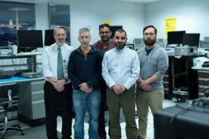
The team developing a GPS receiver for use in and around lunar orbit (from left): Jason Mitchell, Luke Winternitz, Luke Thomas, Munther Hassouneh and Sam Price. (Photo: NASA/T. Mickal)

The team developing a GPS receiver for use in and around lunar orbit (from left): Jason Mitchell, Luke Winternitz, Luke Thomas, Munther Hassouneh and Sam Price. (Photo: NASA/T. Mickal)

The lunar GPS receiver is based on the Goddard-developed Navigator GPS, which engineers began developing in the early 2000s specifically for NASA’s MMS mission, the first-ever mission to study how the Sun’s and Earth’s magnetic fields connect and disconnect. The goal was to build a spacecraft-based receiver and associated algorithms that could quickly acquire and track GPS radio waves even in weak-signal areas. Navigator is now considered an enabling technology for MMS.

Without Navigator GPS, the four identically equipped MMS spacecraft couldn’t fly in their tight formation in an orbit that reaches as far as 115,000 miles from Earth’s center — far above the GPS constellation and about halfway to the Moon.

“NASA has been pushing high-altitude GPS technology for years,” said Luke Winternitz, the MMS Navigator receiver system architect. “GPS around the Moon is the next frontier.”Extending the use of GPS to the Moon will require some enhancements over MMS’s onboard GPS system, including a high-gain antenna, an enhanced clock and updated electronics.

“Goddard’s IRAD (Internal Research and Development) program has positioned us to solve some of the problems associated with using GPS in and around the Moon,” Mitchell said, adding that a smaller, more robust GPS receiver could also support the navigational needs of SmallSats, including a new SmallSat platform Goddard engineers are now developing.

Building on NavCube

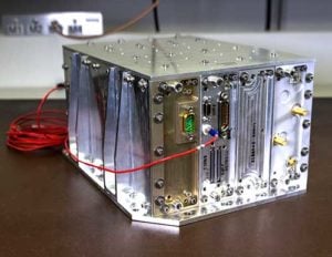
NavCube, which will be tested aboard the International Space Station later this year, is being used as a baseline for a lunar GPS receiver. (Photo: NASA/W. Hrybyk)

NavCube, which will be tested aboard the International Space Station later this year, is being used as a baseline for a lunar GPS receiver. (Photo: NASA/W. Hrybyk)

The team’s current lunar GPS receiver concept is based on NavCube, a new capability developed from the merger of MMS’s Navigator GPS and SpaceCube, a reconfigurable, very fast flight computer platform. The more powerful NavCube, developed with IRAD support, was recently launched to the International Space Station where it is expected to employ its enhanced ability to process GPS signals as part of a demonstration of X-ray communications in space.

The GPS processing power of NavCube combined with a receiver for lunar distances should provide the capabilities needed to use GPS at the Moon. Earlier this year, the team simulated the performance of the lunar GPS receiver and found promising results. By the end of this year, the team plans to complete the lunar NavCube hardware prototype and explore options for a flight demonstration.

“NASA and our partners are returning to the Moon for good,” Mitchell said. “NASA will need navigation capabilities such as this for a sustainable presence at the Moon, and we’re developing enabling technologies to make it happen.”

Publicerad den Lämna en kommentar

Talen-X displays Broadsim Wavefront simulator, Threatblocker and BroadSense Nano at ION JNC 2019

About the Author:

Allison Barwacz is the digital media manager for North Coast Media (NCM). She completed her undergraduate degree at Ohio University where she received a Bachelor of Science in magazine journalism from the E.W. Scripps School of Journalism. She works across a number of digital platforms, which include creating e-newsletters, writing articles and posting across social media sites. She also creates content for NCM’s Pit & Quarry magazine, Portable Plants magazine and Geospatial Solutions. Her understanding of the ever-changing digital media world allows her to quickly grasp what a target audience desires and create content that is appealing and relevant for any client across any platform.

Publicerad den Lämna en kommentar

Trimble launches usage-based service plan for Catalyst GNSS receiver

Trimble Catalyst On Demand enables automated domain-level email address access, which streamlines license allocation for organizations with a large number of users. (Photo: Allison Barwacz)

Trimble Catalyst On Demand enables automated domain-level email address access, which streamlines license allocation for organizations with a large number of users. (Photo: Allison Barwacz)

Trimble’s Catalyst software-defined Global Navigation Satellite System (GNSS) receiver for Android phones and tablets is now available with a usage-based service plan: Trimble Catalyst On Demand.

According to the company, the new service plan is focused on satisfying the requirements of a growing number of industries and organizations who recognize the benefits of using high-accuracy GNSS technology in the field, but need a more flexible payment model.

Trimble Catalyst On Demand provides scalable access to RTK-quality GNSS positioning using an affordable pay-per-use hourly pricing model in addition to the current Catalyst monthly plans, the company added. The service also enables automated domain-level email address access, which streamlines license allocation for organizations with a large number of users.

“Catalyst On Demand is Trimble’s response to the growing number of individuals and organizations needing flexible access to high-accuracy GNSS technology,” said Rachel Blair Winkler, business area manager, mapping and GIS, for Trimble. “By providing a usage-based payment model for Catalyst, we are empowering more users inside and outside the geospatial profession to record positions, navigate to points, measure relative distance and create digital maps. This results in better work and better decisions.”

Trimble Catalyst service subscriptions and the Catalyst DA1 antenna are available through Trimble’s Authorized GIS Distribution Network.

Publicerad den Lämna en kommentar

LiDARUSA integrates lidar scanners with heavy-lift drones

Photo: LiDARUSA

Photo: LiDARUSA

LiDARUSA is announcing the integration of itts UAV scanning systems with the Harris Aerial H4/H6 Hybrid multicopters.

As surveyors and mappers experience growth, they assume larger and larger projects, making longer flight times increasingly important. The Harris Hybrid can provide such flights with lidar and industrial-grade cameras, allowing for far greater coverage in a single flight.

“The beauty of the Harris Hybrid, is that the pilot continues to enjoy the flexibility of a multicopter, availability of fuel, and relatively compact packaging at an affordable price,” said Jeff Fagerman, CEO of LiDARUSA. “While it is louder than an all-electric system, for particularly large, rural projects it is a very nice solution.”

Harris Aerial, a drone manufacturer near Orlando, Florida, builds and sells heavy-lift hybrid multicopters. These copters use a small generator running on 95 (or higher) octane fuel to power the UAV for up to 5 hours. The H6 can carry an A-series HD lidar system of 3 kg for 2.5 hours and a V-series of 5 kg up to 1.5 hours.

For the lidar operator, most projects require only one or two flights. On projects that are relatively flat with a clear line of sight to the horizon in all directions, these systems can cover everything legally possible in a single flight.

LiDARUSA offers the Harris Aerial H4/H6 Hybrid an integrated package with any LiDARUSA scanning system.