Publicerad den Lämna en kommentar

Seen & Heard: Microsatellites, tethered drones and ladybugs

“Seen & Heard” is a monthly feature of GPS World magazine, traveling the world to capture interesting and unusual news stories involving the GNSS/PNT industry.

Madrid stadium drone. (Photo: Elistair)

Madrid stadium drone. (Photo: Elistair)

Tethered drone

Spanish police used a tethered drone system for traffic monitoring, crowd control and surveillance of the UEFA Champions League Final, played June 1 at the Wanda Metropolitano stadium in Madrid. An Elistair tethered U06 Plus drone oversaw 67,000 fans in the stadium and 200,000 in nearby streets. Use of the drone was in response to a heightened terrorist threat level in Spain, making it part of the largest security operation for any sporting event in the Spanish capital. Continuously supplied with power, the drone maintained its position at 50 meters high for 8 hours.

CYGNSS satellite launch. (Artist’s concept/NASA)

CYGNSS satellite launch. (Artist’s concept/NASA)

Tricky Signals

NASA’s eight CYGNSS (Cyclone Global Navigation Satellite System) microsatellites collect radio signals from GPS beacons to characterize hurricanes. A month after launch in December 2016, the CYGNSS team noticed the signals were wavering when the U.S. began to boost the radio power on 10 GPS satellites as they passed over northern Syria. The swings don’t interfere with other scientific uses of GPS, but for CYGNSS the measurements of high winds varied by 5 meters a second or more — the difference between a category-2 and category-3 hurricane. After two years of work, the CYGNSS team has compensated by repurposing a secondary antenna on the satellites to measure GPS signal strength.

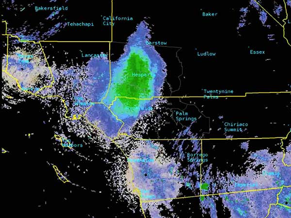
The ladybug blob tracked by Doppler radar. (Image: National Weather Service)

The ladybug blob tracked by Doppler radar. (Image: National Weather Service)

Ladybug, ladybug, fly away home

In this case, California. In June, a millions-strong swarm of ladybugs showed up on radar as a weather event when the insects took to the sky to hunt for aphids. One explanation for the unusual swarm is that a large population of ladybugs had been spread out in a mountainous area, and rising temperatures triggered their mass migration to valleys where they might find an abundance of aphids to eat.

Photo: Auckland Rescue Helicopter Trust

Photo: Auckland Rescue Helicopter Trust

New Zealand joins Aussies on SBAS

Land Information New Zealand (LINZ) will work with Australian counterpart Geoscience Australia to investigate ways to deliver a regional satellite-based augmentation system (SBAS) to significantly improve GPS accuracy. The proposed SBAS will support emergency helicopter crews, providing pilots with accurate vertical guidance for landing, enabling them to reach people faster in difficult terrain and bad weather. The SBAS will also improve the safety of self-driving cars. The new system will improve accuracy to less than a meter, and in some devices to 10 centimeters.

Publicerad den Lämna en kommentar

Without Galileo, life goes on

Galileo's Control Centre in Fucino is used to oversee the satellites' navigation payloads and services.(Photo: ESA)

Galileo’s Control Centre in Fucino is used to oversee the satellites’ navigation payloads and services. (Photo: ESA)

Global markets learned something important from the brown-out of Galileo signals over a week’s time in July: Life goes on without a hiccup in the absence of the European GNSS.

Very unfortunately for the backers and boosters of Galileo, this message will reverberate down through the years. If vital affairs proceed unaffected by Galileo’s travails, or triumphs for that matter, who needs it? The response, a shrug. I’m tempted to say a Gallic shrug, were it not that the Gauls, the French, are prime among the system’s boosters and backers.

I’m among that number as well. Galileo and I have known each other all our lives, all our professional lives. When I started on this magazine 19 years ago, the first story I edited was on Galileo’s public-private partnership.

Galileo then was just a collective gleam in several politicians’ and scientists’ eyes. Look how far it has come: 20 satellites flying in various operational or testing states.

The European GNSS Agency was very careful to point out during the crisis that Galileo is in its initial services phase. Its signals are available for use in combination with other GNSS and are not intended to provide a complete solution by themselves. This status is expressly designed to allow for “the detection of technical issues before the system becomes fully operational.”

So, it doesn’t count. Because, the game hasn’t really started yet. Right?

Not quite.

Because this episode occurred, it will be remembered. Because it lasted so long, it will be factored. Because the official announcements about it were so obscurantist, the system may find it more difficult to regain trust.

Of course a full, careful, in-depth investigation must take place before officially announcing what caused the debacle. But more than was said could surely have been said, during the crisis. A full week now, as of this writing, after the week-long outage concluded, we still have no indication as to which piece of ground equipment or software failed and why there wasn’t a smooth transition from the Italian to the German control station.

Redundancy was built into the system to preclude exactly such failures as this. Why didn’t redundancy work?
Transparency is a rhyming word that goes well with redundancy.

Trust — corporate confidence — is fundamental to installation in multi-GNSS chips, boards, modules, all manner of devices. Four systems compete for spots at a table that may comfortably fit only three. Even three could be a stretch.

GLONASS suffered a much shorter (11-hour) timing glitch in 2014, and has yet to climb back into the public-confidence ring.

Here’s a very public lesson in transparency: When the GPS satellite SVN49 failed rather spectacularly in 2009, the GPS Directorate was very forthcoming, almost embarrassingly so, about what happened and why. GPS never lost a step in the public’s and the industry’s eyes.

Publicerad den Lämna en kommentar

New Arvento vehicle tracker uses u-blox to detect panic breaking

imt.x1 uses u-blox positioning technology to deliver high levels of positioning sensitivity and accuracy.

Photo: u-blox

Photo: u-blox

U-blox and Arvento Mobile Systems are launching the imt.x1 vehicle tracking system. The companies previously partnered on the Treyki Mini tracker.

Arvento’s imt.x1 has a six-axis gyro sensor that can sense three-dimensional movement caused by emergency acceleration, panic braking and directional yaw and drift.

With connectivity options including dual CANBus and Bluetooth, the system is also eCall compatible and captures and provides data for accident analysis and other vehicle tracking functions. The system also uses the next-generation powerful Arm-based microcontroller.

This latest launch is yet another product of a successful, eight-year strategic partnership between Arvento and u-blox. “U-blox is more than a supplier,” said Özer Hıncal, Arvento’s general manager. “As a global leader in the IoT [internet of things] industry providing high-performance IoT modules, platforms and support services, u-blox is our trusted solutions partner, working closely with us to address customer demands and issues.”

As for previous Arvento products, collaboration with u-blox was a key factor in the imt.x1 product development process. The system’s high position sensitivity and accuracy are based on integration of u-blox’s 2G, 4G and 5G-ready cellular modules as well as GNSS modules.

The development of the imt.x1 aligns with Arvento’s vision and mission as a developer of advanced fleet telematics and vehicle tracking devices and will be available from August 2019.

Publicerad den Lämna en kommentar

Racelogic announces Galileo update for SatGen software

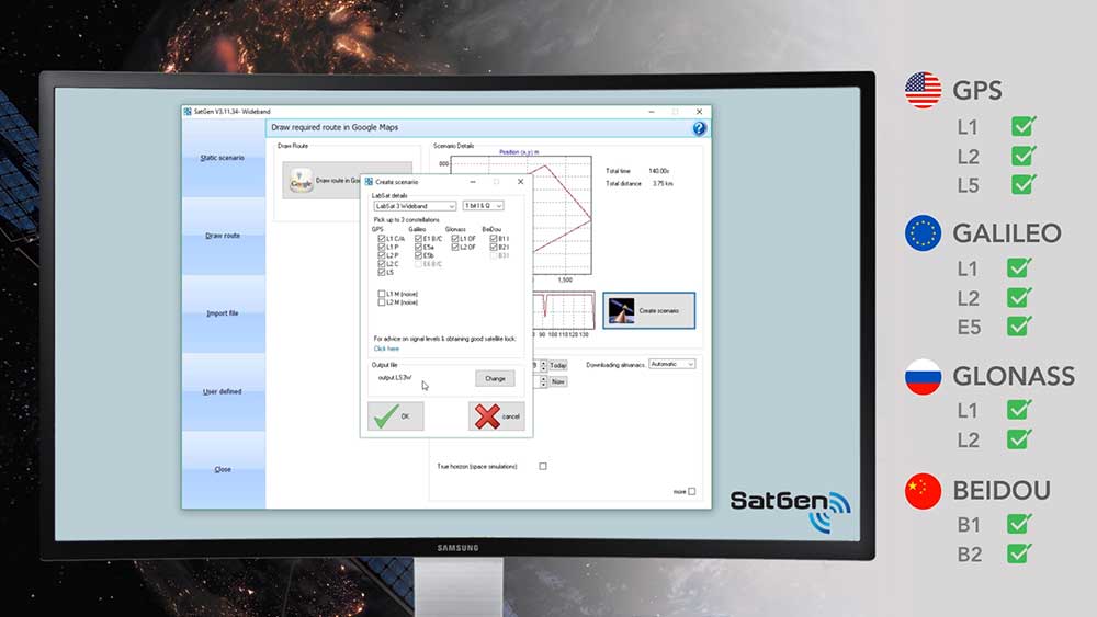
Image: Racelogic

Image: Racelogic

Racelogic Ltd., experts in the field of GPS testing and data logging, has announced the latest update to its SatGen GNSS simulation software for PC, which now incorporates Galileo RF simulation.

Designed to create a GNSS RF I&Q or IF data file based on a user-generated trajectory file, the updated software can now accurately simulate the European Galileo GNSS satellite constellation alongside existing GPS, GLONASS and BeiDou RF signal generation.

The full range of Galileo frequencies that SatGen can simulate are Galileo E1 B/C, E5a, E5b and E6 B/C (see below for details).


SatGen 3.11.39 Galileo simulated RF frequencies

Galileo E1 B/C. Transmitted by all Galileo satellites on the E1 (1575.42 MHz) frequency, same as GPS L1. Standard precision Open Service signal consisting of Data component B and Pilot component C.

Galileo E5a. Transmitted by all Galileo satellites on the E5a (1176.45 MHz) frequency, same as GPS L5. Open Service signal consisting of Data component I with the F/NAV navigation message and Pilot component Q. Intended to be used together with E1 B/C to improve accuracy.

Galileo E5b. Transmitted by all Galileo satellites on the E5b (1207.14 MHz) frequency, same as BeiDou B2. Open Service signal consisting of Data component I with the I/NAV navigation message and Pilot component Q. Intended to be used together with E1 B/C to improve accuracy.

Galileo E6 B/C. Transmitted by all Galileo satellites on the E6 (1278.75 MHz) frequency. High accuracy Commercial Service signal consisting of Data component B and Pilot component C. Because the content of the C/NAV navigation message is encrypted, SatGen transmits a dummy navigation message, which should be accepted by all receivers.


“Given the vast improvements in navigation and timing that Galileo has brought to its global users, we extremely excited to be releasing a version of SatGen that allows engineers to generate Galileo-specific scenarios for their test procedures,” said Mark Sampson, LabSat product manager.

Other changes to the software include various user interface tweaks, performance optimization and fixes.

For more information on SatGen, contact Katie Harland or call Racelogic LabSat at +44 1280 823 803.

SatGen simulation software now features Galileo RF simulation from Racelogic VBOX on Vimeo.

Publicerad den Lämna en kommentar

SMDC takes lead in Army’s navigation and PNT operations

News from the U.S. Army Space and Missile Defense Command/Army Forces Strategic Command

The secretary of the United States Army has designated the U.S. Army Space and Missile Defense Command/Army Forces Strategic Command as the Army’s representative to identify and advocate for positioning, navigation and timing (PNT) information as well as establish and formalize joint navigation warfare, or NAVWAR, requirements.

“Navigation warfare is really about taking a look at different position, navigation, and timing signals and figuring out how the signals flow; the potential for adversaries to disrupt our ability to use them in the future; and how can we not only protect ourselves from the enemy denying us with those abilities, but also how can we do the same to our enemies and affect them and disrupt them in a multi-domain operational environment,” said Col. Timothy G. Dalton, USASMDC/ARSTRAT U.S. Army Training and Doctrine Command, or TRADOC, Capabilities Manager for Space and High Altitude, or TCM SHA.

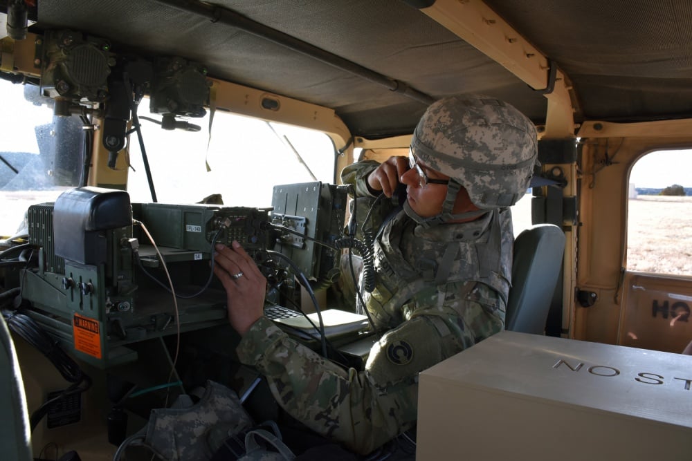
Soldiers in the field learn how to operate in a NAVWAR environment. (Photo: U.S. Army)

Soldiers in the field learn how to operate in a NAVWAR environment. (Photo: U.S. Army)

What NAVWAR Does. NAVWAR allows the Army to take deliberate defensive and offensive actions to assure U.S. forces PNT information through coordinated employment of space, cyberspace and electronic warfare operations. PNT data enables the Army to precisely move, shoot and communicate; extend its operational reach; control the tempo of operations; and perform mission command, all without adversarial interruption.

NAVWAR capabilities include electronic protection which includes systems and capabilities required to defend platforms and systems against electronic acts in the GNSS electromagnetic spectrum.


The Army has more than 250,000 GPS-dependent systems.


Additionally NAVWAR provides electronic support to sensors and software used to search for, intercept, identify, locate or localize, and report sources of intentional and unintentional radiated GNSS electromagnetic interference for mitigation and planning future operations.

NAVWAR can also provide electronic attack with capabilities to seize and sustain the initiative by actively degrading or denying the GNSS electromagnetic spectrum to adversaries in multi-domain operations.

The Army is dependent on the use of this data with a typical brigade combat team depending on more than 28 different systems and 600 total systems that leverage PNT. The Army has more than 250,000 GPS-dependent systems.

“As the Army goes forward in multi-domain operations, what we see the battlefield becoming is a contested environment,” Dalton said. “What that means is there are adversaries that will look to challenge the United States across all operational phases and domains. These enemies will have the capability to disrupt signals, like GPS, that can impact a wide range of military and civilian activities.

New NAVWAR Concept. SMDC is developing a TRADOC-sponsored Army NAVWAR concept that will be used to establish a baseline for how the Army will execute the NAVWAR fight.

The Army is highly dependent on the use of GPS-delivered PNT data. NAVWAR prevents the use of GPS by hostile forces while ensuring unimpeded use for U.S. forces and allies.

“In the command’s advocacy role we work with the joint and Army communities to examine what the Army needs to be able to accomplish the mission through navigational warfare,” Dalton said. “We work with a community of interest to determine the requirements that will build capability and reduce shortfalls in this mission area.

“This includes activities like updating doctrine, our organizational structure, ability to train the force, and ultimately determine if we need additional equipment, or holistic solutions to protect capabilities and disrupt the enemy on the navigation warfare side,” he added.

Training and Research. SMDC, in conjunction with U.S. Forces Command and the Joint Navigation Warfare Center, supports training events under degraded GPS conditions. The goal is to enable tactical formations to develop and train tactics, techniques and procedures that enable Army formations to work.

“We help develop and focus the capability requirements for the Army,” Dalton said. “But we are integrating with a larger community, led by the Assured Positioning, Navigation and Timing Cross-Functional Team that is focused on modernizing the Army in this mission area.”

SMDC is the Army lead for institutional unity of effort on NAVWAR with several research, development, test and evaluation and capability integration efforts working on the issue independent of one another.

“It is definitely an exciting time for NAVWAR,” Dalton said. “The Army, services and Department of Defense, as a whole, have started to embrace the importance of this mission area and understand the competitive advantage the U.S. and our partners can gain while denying the adversary the ability to conduct operations with respect to navigational warfare.”

Publicerad den Lämna en kommentar

AFRL tests Chimera to battle spoofers and hackers

L1C Signal Could Be Watermarked as Countermeasure

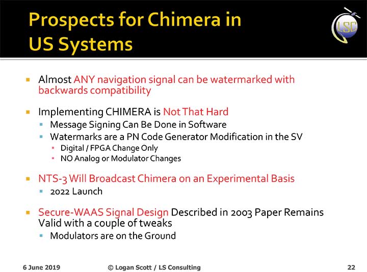
The U.S. Air Force will load a new signal feature, designed to make spoofing detectable, aboard a satellite that will broadcast it from space as a security overlay for the GPS L1C signal, but not until 2022 at the earliest.

The Chips Message Robust Authentication (Chimera) is now in testing under the auspices of the Air Force Research Laboratory (AFRL), getting ready to fly on the Navigation Technology Satellite 3 (NTS-3), which will trial a number of new PNT techniques and technologies.

Chimera inserts encrypted digital signatures and watermarks within the L1C signal. A GPS receiver with the requisite additional capability for this purpose can then detect whether the signal is real or fake and also authenticate the location of a GPS receiver that is remotely located.

This key feature could provide a defense against hacking by blocking access from anyone unable to prove they are at an anticipated or licensed site. Hacking, of course, is a growing threat to all sorts of infrastructure: financial, security, utility grid and more.
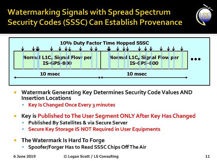
Presentation slide from PNT Advisory Board briefing by Logan Scott.

Presentation slide from PNT Advisory Board briefing by Logan Scott.

Consultant Logan Scott first proposed the Chimera technology in 2003, when he affirmed that “Some of the spoofing detection measures in wide use offer a false sense of security. Authenticatable signal architectures are needed.” In June, he made a presentation to the PNT Advisory Board: “The Role of Civil Signal Authentication in Trustable Systems.” The two slides accompanying this article appeared in that presentation.

“Chimera represents a fundamental paradigm shift in PVT security paradigms,” Scott related in a subsequent conversation. “Trust takes time and memory on a personal level and, in this case, in GNSS signals, too.
“You don’t trust somebody as soon as you meet them. Over a period of time, you get to know them. If you can’t remember anything, you can’t develop trust either.”

“In the GNSS world, there are a lot of applications where you don’t need output in real time,” Scott said. “For example, to align an inertial. The inertial provides the real-time aspect. You don’t want to send anything to the IMU that is factually incorrect. When building to aid inertial, I can afford to have a delay from real time as long as I tell it where it was 10 seconds ago. The power of that is, if I don’t have to give real-time output, I can ponder and think about things.

“If a spoofer attacks, there’s an evolution that happens there. If I, as the receiver, can see the developing scenario, and how it starts to look at little screwy, I can stop and not send anything to the IMU that might corrupt it.”

How It Works. The core concept of Chimera involves the satellites sending encrypted watermarks, encoded into the signal by the satellite. After a slight delay, the satellite sends the key used to generate those encrypted watermarks. Once a key is sent, the system changes the key.

Since the receiver has already recorded the signal with its watermarks before the key is sent, spoofers cannot know the correct key ahead of time, in time to insert correct watermarks of their own. This means that any spoofed signals can be easily spotted: either the subsequent key won’t match up with the spoofed watermarks, or there will be no watermarks at all.

“Another reason it’s hard for someone to generate these watermarks on their own is because the signal is buried below the noise,” added Scott. “The watermarks are hidden.”

A number of different time delays between signal and key are possible within this concept and within the general set-up of GPS. Scott and the AFRL have, for various practical reasons, provisionally settled on a 6-second delay on the fast watermark channel and a 3-minute delay for the slow watermark channel.

The signal enhancement could be incorporated into the Wide Area Augmentation System (WAAS). This has yet to be fully determined, but this route would lead to a faster implementation of Chimera. Scott thinks that going the WAAS route could bring Chimera capability into action within two years.

The AFRL, however, is looking at a much longer timeline. The NTS-3 satellite, where it first intends to test Chimera, will not launch until 2022 — three years hence. And that’s only a test, not an enactment or a system-wide implementation.
Slide: Logan Scott

Slide: Logan Scott

Verification. One key benefit for commercial entities, particularly those in financial infrastructure and other systems that increasingly fall victim to hacking, is that Chimera gives them the ability to verify customers’ or partners’ locations before granting any kind of access. The customer’s or other erstwhile user’s GPS receiver would record the full signal, including the watermarks, and transmit that data to the company, entity or data center needing location verification, before the keys are published. Each combination of watermarks and signals is unique to the place where it was recorded, thus it is possible to tell whether the user is actually where they say they are, or in an authorized or pre-identified location before granting access or accepting further input (such as commands).

Scott claims that Chimera affords a 99.9% probability of detecting spoofers. “I have a 99.9% chance of detecting that the watermark is not there, because they don’t know how to generate it. This is based on how you’re processing the signal. It’s designed to be very flexible in how the receiver uses the signal.”
Just One Problem. Receiver manufacturers will have to develop new Chimera-capable receivers, and customers will have to buy them. An additional cost for the added processing, above and beyond that required for normal GPS operation, is unavoidable.

And a Hiccup. Chimera, while an acronym, is as a name perhaps not a totally felicitous choice. In Greek mythology, the chimera is a fire-breathing female monster with a lion’s head, a goat’s body, and a serpent’s tail. These historic ancestors have evolved into the word’s more current use: a thing that is hoped or wished for but that is in fact illusory or impossible to achieve.

AFRL Wants Your Opinion. The Air Force Research Laboratory seeks feedback from the PNT community on the Chimera enhancement for the L1C signal. The specification is here. And, you can download a comment form

Publicerad den Lämna en kommentar

What value does precise timing hold for GPS?

This just in: a Final Report on the Economic Benefits of GPS. Sponsored by National Institute of Standards and Technology, the study began a couple of years ago, conducted by RTI International, one of the nation’s oldest and largest research firms.

The report runs 306 pages and examines the benefits derived from GPS by 10 U.S. industries: agriculture, electricity, finance, location-based services, mining, maritime, oil and gas, surveying, telecommunications and telematics.

Among other issues, the research explored the potential effect of a 30-day GPS outage, assuming that other GNSS would be disrupted as well, and found the outage would have a $1 billion per-day impact. The 30-day outage scenario was specifically added at the request of the National Executive Committee for Space-Based Positioning, Navigation and Timing.

While a disruption lasting 30 days seems unlikely, as the report says, “understanding the relative magnitude of potential impacts is important for making informed decisions about investments in back-up systems and contingency plans.”

Relating a sense of the full report is beyond the scope of this small space, but I encourage all readers to download it (link at ) and examine it either in its entirety, or in its applicability to your particular industrial sector. Here

I’ll focus briefly on GPS’s precise timing capability, which supports telecommunications.

Precise timing enables service providers to more efficiently use available spectrum and deliver high-speed wireless services. Given American society’s intensive use of these two lifelines, it is not surprising that benefits related to telecommunications are substantial: $685 billion, more than twice that of the second-ranked industry in terms of economic benefits, and more than half of the total benefits.

GPS reduces/eliminates dropped calls and increases bandwidth, enabling more advanced networks such as 4G LTE, which we now have, and 5G, which is coming at breakneck speed.

Wireless network infrastructure has evolved to rely heavily on GPS. In fact, GPS has shaped the telecommunications industry: its technology has evolved around GPS. See last month’s cover story for more details.

Interestingly, to calculate the economic benefits of GPS in the telecom sector, the researchers used two indices as a baseboard: radio spectrum auction data showing telecom service providers’ willingness to pay (WTP) for spectrum to provide 4G LTE, and consumers’ WTP for the broadband speeds enabled by 4G LTE. Both these numbers are going up, up, up.

While the number of wireless subscribers in the United States increased at a respectable rate from 2009 to 2017 — about 35% — the average bandwidth used by those subscribers expanded at an astonishing 2,200%!

Experts interviewed on the prospect of an extended GPS outage agreed that, eventually, a user would have to remain stationary to maintain a wireless connection, albeit a degraded one. After some time of steady degradation of quality of service, wireless service would cease to function altogether.

It’s hard to imagine which would be worse: a world without mobile telecoms, or one without GPS. However, we don’t have to strain, because in this case we would lose both.

To avoid the unimaginable…plan, plan, plan, and backup, backup, backup.

Publicerad den Lämna en kommentar

SiTime offers MEMS timing solutions for rugged GNSS

Endura MEMS timing products. (Photo: SiTime)

Endura MEMS timing products. (Photo: SiTime)

SiTime Corp. has unveiled its Endura micro-electro-mechanical system (MEMS) timing solutions for aerospace and defense applications including precision GNSS, as well as field and satellite communications, avionic and space.

The Endura products are engineered to provide high performance in harsh conditions — severe shock, vibration and extreme temperature — that are routinely experienced in these applications.

SiTime offers customers 5 million possible part numbers that can be created from 17 programmable products.

“When exposed to high levels of shock, vibration, and extreme temperatures, legacy timing components have been prone to failure, degrading system performance and reliability,” said Piyush Sevalia, executive vice president of marketing. “To solve these problems, SiTime created an oscillator system of silicon MEMS, analog circuits, compensation algorithms, and advanced packaging, which is designed to outperform any other available timing solution in harsh environments.

“For example, Endura precision TCXOs deliver 4 parts per trillion per g (ppt/g) of acceleration sensitivity, which is 50 times better than legacy quartz-based solutions. With such performance, we believe that Endura will transform the oscillator landscape in aerospace and defense.”

Highlights of the company’s solutions include:

  • 4 parts per trillion per g force of acceleration (50 times better than quartz)
  • Supports –55º C and +125º C operation
  • Key timing specifications conform to MIL-PRF-55310
  • Five million possible part numbers

Endura Super-TCXOs (temperature compensated oscillators) for use in high-speed communications and GNSS applications include:

  • SiT5146/SiT5147 – 1 to 220 MHz, ±0.5 to ±2.5 ppm, -40°C to +105°C
  • SiT5346/SiT5347 – 1 to 220 MHz, precision ±0.1 to ±0.25 ppm, -40°C to +105°C
  • SiT5348/SiT5349 – 1 to 220 MHz, ultra-precision ±0.05 ppm

SiTime’s portfolio of commercial off-the-shelf (COTS) Endura products spans six oscillator types and 17 products. All devices offer programmable options such as frequency, operating voltage and stability.

In addition, some devices offer specialized programmable features such as spread spectrum, pull-range, and differential output type.

Endura products are available with up to two grades of acceleration sensitivity, as low as 4 ppt/g (typical). This breadth of products provides customers with a large selection and the ability to configure each device for their application requirements.

Endura products are also designed for continuity of supply for long-life programs.

Publicerad den Lämna en kommentar

Jane Goodall Institute releases StoryMap highlighting chimp habitat conservation

In collaboration with Esri and Blue Raster, the Jane Goodall Institute (JGI) released a StoryMap that highlights Jane Goodall’s research, her Tacare approach and chimpanzee habitat conservation.

The StoryMap highlights how many remaining chimpanzee habitats are outside of protected areas, and how that habitat is in the care of local people and decision-makers. It also walks through JGI’s Tacare community-centered conservation approach which employs GIS and other tools to empower local communities in the pursuit of local conservation.

The StoryMap features a map showing where chimpanzees live in Tanzania. (Photo: Esri, HERE, GARMIN, USGS | Esri © OpenStreetMap contributors, HERE, Garmin, FAO, NOAA, USGS | Lilian Pintea, the Jane Goodall Institute and TANAPA)

The StoryMap features a map depicting where chimpanzees live in Tanzania. (Photo: Esri, HERE, GARMIN, USGS | Esri © OpenStreetMap contributors, HERE, Garmin, FAO, NOAA, USGS | Lilian Pintea, the Jane Goodall Institute and TANAPA)

The StoryMap explains the start of Jane Goodall’s career and how she discovered that chimpanzees make and use tools, which led to the discovery that chimpanzees share 98.6% of human DNA. It also covers the importance of conserving chimpanzees and their habitats, specifically noting their habitats in Tanzania. Finally, it explains how Tanzanians are using mobile technology, paired with the Esri Survey-123 app, to turn land-use plans into reality.

The StorMap also offers an overview of JGI’s Tacare community-centered conservation approach, which emphasizes four steps: engage, listen, understand and act.

Check out the map here.


Earlier this year, the Jane Goodall Institute also partnered with Esri to develop a set of tools that will help communities map and manage the ecosystems around them, aided by GIS software.

Publicerad den Lämna en kommentar

NASA Disasters Program aids with disaster relief efforts

Satellite imagery and mapping have proven to be critical technologies when it comes to disaster relief efforts.

The NASA Earth Science Disasters Program has harnessed these technologies to help communities and governments recover from natural disasters like earthquakes, hurricanes and more.

“[The goal of the program is to] try to prevent natural disasters or limit their impact and also help people recover from them more quickly,” Jeremy Kirkendall, senior GIS administrator for the NASA Disasters Program, told GPS World in an exclusive interview at the 2019 Esri User Conference in San Diego. “We provide the products free to anyone to use, and data is only available if there is a good satellite pass.”

When a natural disaster strikes, researchers at the NASA Disasters Program will take satellite imagery of the affected location and create a map to show what the area looks like from an aerial perspective. Authorities who request this information can then compare the disaster map with maps of what the area looked like before the disaster took place.

“We do take requests from agencies or governments for disasters if they need help if data is available,” Kirkendall said. “We’ll create the products that show where the earthquake damage happened, where the fire burned or where the flooding is, and then users take that — combined with their local information — to determine what needs to be checked.”


For example, the NASA Disasters Program was able to map out the magnitude 6.4 July 4 Southern California earthquake.

“The earthquake that happened on July 4 caused a lot of deformation to the ground, so we mapped out that surface deformation and shared that information with other emergency managers, the Federal Emergency Management Agency, National Guard and U.S. Navy,” Kirkendall said. “You can look at things like roads, utilities, underground pipes for natural gas or geothermal wells, or fiberoptic cables. Then when you provide the product to these end users, they can overlay it with utility and infrastructure information to identify what’s the most at risk and what needs to be investigated.”

Sometimes, when a natural disaster occurs over a longer period of time, data is mapped throughout the duration of the occurrence, as well. This can help with search-and-rescue missions, infrastructure repairs and post-disaster analysis.

“We will create products during responses that can last a long time, like for Hurricane Florence or the flooding that recently happened in the Midwest,” Kirkendall said. “We’ll keep turning out flood products day after day when there’s good satellite passes that show that information.”

Kirkendall added that the National Guard has used the live data, along with 911 calls, to find individuals trapped in flooded houses. The data also serves as a tool for post-disaster analysis to understand where damage occurred, ways to fix it and how to prevent it from happening again.

“The program itself is gearing toward a resiliency effort, where we can provide these products when communities says, ‘We get flooded here all the time, over and over,’” Kirkendall said. “That’s where we need to be prepared to fix something. We need to do something to prevent that.”