Publicerad den Lämna en kommentar

Autonomous vehicles can reduce road fatalities

Mothers Against Drunk Driving (MADD) has partnered with Velodyne Lidar, a provider of real-time 3D perception systems for a range of commercial applications, including autonomous vehicles. The initiative includes a website on the safety benefits of autonomous vehicle technology (see velodynelidar.com/madd-partnership.html) and an October conference on autonomous safety.

“We have learned that technology is essential to getting us to our goal of zero deaths caused by drunk driving,” said MADD President Helen Witty. “Autonomous vehicle technology holds the incredible promise of helping us eliminate drunk driving.”


World Safety Summit on Autonomous Technology
Levi’s Stadium in Santa Clara, California | October 2, 2019

The summit is designed to advance understanding of the safety benefits that can be achieved with autonomous vehicle technology. It is designed for business, government, public safety and community leaders. Attendees will have the opportunity to ride in autonomous vehicles.


Marta Hall, Velodyne Lidar’s president and chief business development officer, added, “Our goal is to design, develop and mass-produce lower cost lidar sold for every model of car and truck.”

The two organizations partnered in 2018 to create the website with information on how autonomous vehicles can help prevent roadway collisions. The site explains the basics of autonomous driving in easy-to-understand language for all audiences. Content modules include “Lidar 101,” explaining how lidar sensor technology is an essential component of self-driving vehicles.

A 3D lidar sensor such as the Velodyne Alpha Puck can deliver information to help enable vehicle autonomy and advanced driver-assistance systems. (Image: Velodyne)

A 3D lidar sensor such as the Velodyne Alpha Puck can deliver information to help enable vehicle autonomy and advanced driver-assistance systems. (Image: Velodyne)

“The promise of safe, self-driving cars is very exciting, particularly for those of us who have seen the devastation that impaired driving and human error can bring,” said former MADD President Colleen Sheehey-Church.

Puck Sensor.
The Velodyne Alpha Puck is a lidar sensor specifically made for autonomous driving and advanced vehicle safety at highway speeds. In a session at July’s Automated Vehicle Symposium, company speakers presented “High-Definition 3D Lidars: An Integral Part of Future Autonomous Driving,” including use cases that have proven elusive for solutions based on camera and radar; and “State of Solid-State 3D Lidar,” a technical presentation on application-specific integrated circuits (ASICs).

“Core lidar electronics are moving from a printed circuit board to an ASIC, which provides advantages such as higher density, lower cost and improved reliability,” said UAV and Robotics Business Manager Frank Bertini. “The trend roughly follows Moore’s Law, leading to dramatic decreases in size, weight and cost over relatively short time periods.”
Publicerad den Lämna en kommentar

Arm to offer Swift Navigation positioning for autonomous vehicles

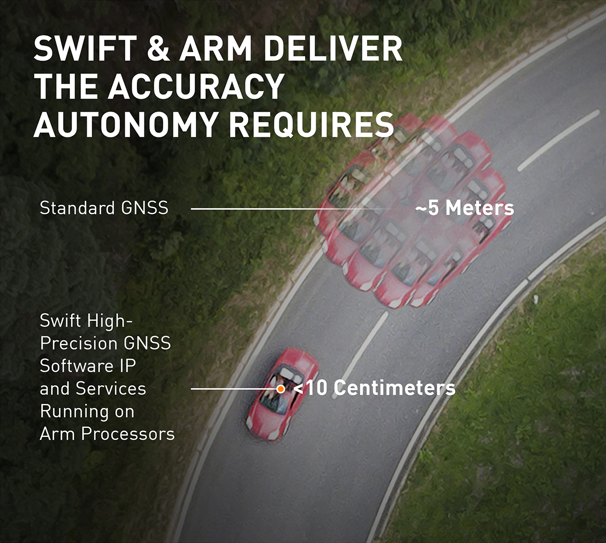
The Swift/Arm partnership means Arm will offer Swift Navigation’s high-integrity, high-accuracy GNSS positioning solutions as an option on Arm-based platforms to developers of autonomous and connected vehicles. (Image: Swift Navigation)

The Swift/Arm partnership means Arm will offer Swift Navigation’s high-integrity, high-accuracy GNSS positioning solutions as an option on Arm-based platforms to developers of autonomous and connected vehicles. (Image: Swift Navigation)

Swift Navigation is partnering with Arm, a global leader in semiconductor IP.

The partnership means Arm will offer Swift Navigation’s high-integrity, high-accuracy GNSS positioning solutions as an option on Arm-based platforms to developers of autonomous and connected vehicles.

Swift Navigation is a San Francisco-based tech firm redefining GNSS positioning technology for autonomous vehicles.

Standard GNSS positioning is three to five meters in depth which is not suitable for safety-critical systems requiring lane-level accuracy. For higher levels of autonomous capability, a vehicle needs to be able to determine its absolute location. To achieve this, high-precision localization is needed to get to accuracy down to the centimeter.

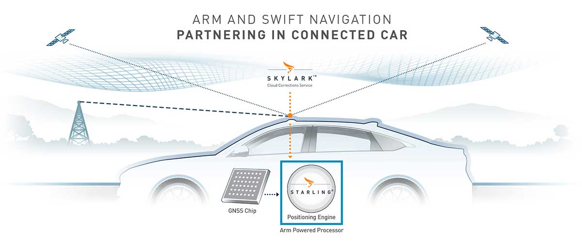
Swift’s partnership with Arm will deliver a high-integrity, high-accuracy GNSS positioning solution for silicon makers and Tier 1 and 2 auto suppliers to integrate precise positioning into the sensor suite.

Swift Navigation’s Starling is a GNSS positioning engine designed for just such automotive and autonomous vehicle applications. Starling’s software enhances the measurements for commercially available GNSS receivers to provide true precision and integrity capabilities. Starling is receiver-agnostic, so it is ideal for Arm customers as it works with a variety of automotive grade chipsets and inertial sensors.

Swift’s partnership with Arm will deliver a high-integrity, high-accuracy GNSS positioning solution for silicon makers and Tier 1 and 2 auto suppliers to integrate precise positioning into the sensor suite. (Image: Swift Navigation)

Swift’s partnership with Arm will deliver a high-integrity, high-accuracy GNSS positioning solution for silicon makers and Tier 1 and 2 auto suppliers to integrate precise positioning into the sensor suite. (Image: Swift Navigation)

Swift and Arm are working together to provide developers of autonomous and connected vehicles a cost-effective, scalable and high-integrity positioning solution. Starling is designed to be compatible with industry leading silicon makers who build their solutions on Arm.

Starling works with a variety of GNSS measurements engines and is a hardware proven, end-to-end solution, tunable for the specific requirements of a customer’s platform. This partnership elevates the capabilities of the connected car and simplifies the integration of high-precision GNSS into Tier 1 and 2, Silicon and Platform and Automotive OEM vendors.

“We are pleased to join the ecosystem of Arm technology partners to deliver precise positioning solutions to its automotive and autonomous vehicle customers,” said Timothy Harris, chief executive officer of Swift Navigation. “This partnership opens up a broader audience of customers who can benefit from Swift’s positioning technology and builds on our mission to enable a future of autonomous vehicles.”

“As we strive toward an autonomous future, the requirements of the automotive market are changing, and a more solution-based approach is needed,” said Dipti Vachani, senior vice president and general Manager, automotive and IoT line of business, Arm. “The combination of Arm IP uniquely designed for automotive and Swift’s GNSS solution gives our partners another key component on the road to the effective deployment of autonomous vehicles at scale.”

Available for purchase today for Arm-based processors, the Starling positioning engine provides a rapid deployment, low total cost of ownership solution to enable widespread adoption of ADAS, connected car, C-V2X and autonomous solutions.

Interested parties should visit this website to get more information on using the Starling positioning engine on Arm-based devices.

The joint solution will be also be showcased at the IAA New Mobility World 2019 event from Sept. 10-15 at the Arm booth, Hall 5.0, stand A10, Frankfurt Messegelände.

Publicerad den Lämna en kommentar

Septentrio unveils GNSS/INS receiver for drones

Septentrio has introduced a GNSS/INS receiver designed specifically for unmanned aerial vehicles (UAVs). The AsteRx-i S UAS combines GNSS technology with industrial-grade inertial sensor to provide high-accuracy, reliable positioning and 3D orientation (heading, roll, pitch) to aerial drones and other compact robotic systems.

Septentrio’s introduction of AsteRx-i S UAS builds on top of the success of the company’s existing UAV products, AsteRx m2 and m2a UAS. Its optimized SWaP (size, weight and power) increases UAV battery life resulting in longer flight times and improved productivity.


Septentrio will showcase the new AsteRx-i S at

  • ION GNSS+, Sept. 16-20, Miami, Florida, U.S.
  • Intergeo, Hall 1, Booth D1.040, Sept. 17-19, Stuttgart, Germany

This credit-card-sized receiver is designed for easy integration into any UAS (unmanned aerial system) and is compatible with popular autopilots such as Pixhawk and ArduPilot. It is a single-package GNSS/INS product, with an on-board IMU (inertial measurement unit) and standard connectors, allowing flexibility of sensor choice.

Photo: Septentrio

Photo: Septentrio

“Quick receiver integration makes the lives of our customers easier. It also speeds up their system’s time-to-market,” said Danilo Sabbatini, Product Manager at Septentrio. “Our goal was to combine a high-performance product with a simple and flexible plug-and-play integration design, suitable for any aerial system.”

Septentrio reliable centimeter-level positioning is based on multi-frequency, multi-constellation GNSS technology (GPS, GLONASS, Galileo, BeiDou, QZSS). AsteRx-i S UAS combines a GNSS receiver with a high-quality IMU to deliver reliable positioning together with 3D orientation.

Photo: FAA

Photo: FAA

Septentrio’s unique GNSS — IMU integration algorithm provides continuous positioning during short GNSS outages (coasting) which can happen in flight near high structures, under bridges or during banking turns.

AsteRx-i S UAS comes with built-in industry leading Advanced Interference Mitigation (AIM+) technology. In aerial drones, where lots of electronics are crammed into a small space, neighboring devices can emit electromagnetic radiation which interferes with GPS and GNSS signals.

AIM+ offers protection against such interference resulting in faster set-up times and robust continuous operation. A built-in power spectrum plot allows users to analyze interference, helping locate its source and mitigating it.

Publicerad den Lämna en kommentar

Geodata.se – Nyhetsbrev nr 5 – 2019

Nationella geodatastrategin och digitaliseringen av samhällsbyggnadsprocessen

Tisdag den 15 oktober, kl. 12-13, bjuder Lantmäteriet in till webbsänt lunchseminarium för att informera om arbetet med nya aktiviteter i Geodatarådets handlingsplan 2019-20, uppdatering av den Nationella geodatastrategin samt hur långt vi har kommit i arbetet med smartare samhällsbyggnadsprocess. Du deltar i webbsändningen via denna länk.

Uppdrag Grundkarta

Detaljplan

En detaljplan består, enligt 4 kap. 30 § PBL, av en plankarta med tillhörande planbestämmelser och en planbeskrivning. Plankartan skall visa för vilket område detaljplanen gäller. Detaljplanen är juridiskt gällande och ska följas för bygglov och vid fastighetsbildning.

För att detaljplanen ska kunna åskådliggöras tas det fram en Grundkarta som visar hur ”verkligheten” ser ut när planen antas samt en fastighetsförteckning. Grundkartan ska vara aktuell och innehålla nödvändig informationsmängd med den geometriska kvalitet som krävs för detaljplanens ändamål.

Det är grundkartan som planförfattaren (kommunen) ska förhålla sig till vid utformning av detaljplanen och planbestämmelserna, detaljplanen ska anpassas efter grundkartans innehåll.

uppdrag grundkarta.png

Uppdrag Grundkarta

I arbetet med regeringsuppdraget Digitalt Först – en smartare samhällsbyggnadsprocess har det identifierats ett behov att standardisera de informationsmängder som ligger till grund för begreppet Grundkarta i PBL. Lantmäteriet har från regeringen fått rätt att meddela föreskrifter om standarder för utformning av Grundkarta enligt 5 kap. 8 § PBL.

Styrgruppen för projektet Smartare samhällsbyggnadsprocess har beslutat att Uppdrag Grundkarta i ett första steg inte ska ta fram en föreskrift utan en handledning för Grundkarta. Anledningen är att det ännu inte finns informationsspecifikationer klara för alla informationsmängder i grundkartan.

Vi kommer därför i steg 1 av vårt uppdrag att under hösten 2019 och våren 2020 ta fram en handledning (handbok) för Grundkarta. Handledningen ska innehålla processer, informations-mängder, kvalitetsuppgifter och utseende (2D och 3D) med koppling till specifikationerna.

Handledning Grundkarta ska vara klar för beslut av styrgruppen till halvårsskiftet 2020 och därefter publiceras på Lantmäteriets hemsida. Vi kommer att utgå från den mall som används för HMK, med tydliga rekommendationer och förtydligande text.

Kommuner, andra myndigheter och systemleverantörer kommer att delta i arbetet, i arbetsgrupp och referensgrupp samt för dialog och remiss.

I steg 2, med början hösten 2020 planeras delar av handledningen att utgöra grunden för att ta fram Föreskrift Grundkarta.

Särskilt värdefulla datamängder

Välkommen att delta på webbseminarium om PSI och särskilt värdefulla datamängder.

Seminariet sänds den 11 september kl. 09:00 och pågår ca 30 minuter.
Ni hälsas välkomna av vår GD Susanne Ås Sivborg, och det kommer ges information om uppdraget, PSI-direktivet och det pågående arbetet.

Under sändningen finns ingen möjlighet att ställa frågor eller ha dialog, utan vi hänvisar till psi@lm.se för de eventuella frågor eller funderingar som dyker upp.

Det kommer även finnas möjlighet att ta del av informationen i efterhand via www.lantmateriet.se/psiuppdrag (öppnas i nytt fönster).

För att koppla upp er den 11 september kl. 09:00 följ denna länk (öppnas i nytt fönster).

Nyhet från geodata.se, orginal inlägg

Publicerad den Lämna en kommentar

GMV to develop autonomous vehicle positioning for BMW

GMV has been awarded a contract for development of a precise GNSS positioning system with integrity for the new generation of autonomous vehicles of the German carmaker BMW Group.

The Spanish multi-national’s technology solution is going to be developed for the first time in BMW Group’s autonomous vehicles. GMV’s positioning software calculates the vehicle’s position and other magnitudes, using advanced GMV-developed algorithms, including components that have already been patented. These algorithms have been especially modified and adapted to meet BMW Group’s performance and safety requirements.

Photo: BMW Group

Photo: BMW Group

The developed software will abide by the most demanding automotive standards and the highest quality levels of safety-critical software, GMV said.

Another key component provided by GMV is a GNSS correction service to be run in a secure infrastructure using data from a global network of monitoring stations to be set up by GMV under this contract.

This new project cements GMV’s position as a supplier of GNSS-based autonomous-car positioning solutions, the company said.

“GMV has been investing for many years in the key GNSS technologies that are essential for autonomous driving systems,” said Miguel Ángel Martínez Olagüe, GMV’s general manager of Intelligent Transportation Systems. “For our company this contract represents a unique opportunity to capitalize on all that effort, providing a product of outstanding performance for the automotive industry.”

Publicerad den Lämna en kommentar

Skyfront drone performs first BVLOS flight under FAA Part 107

Members from the Alaska IPP team gather around the Skyfront Perimeter UAV after a successful BVLOS mission. (PRNewsfoto/Skyfront Corp.)

Members from the Alaska IPP team gather around the Skyfront Perimeter UAV after a successful BVLOS mission. (PRNewsfoto/Skyfront Corp.)

Skyfront’s Perimeter 4 long-range hybrid gas-electric drone this summer successfully performed the first civilian beyond-visual-line-of-sight (BVLOS) flight without visual observers under the FAA’s Part 107 rules.

The flight serves as a significant step toward the safe integration of unmanned aerial vehicles into the national airspace, according to the company.

During the round-trip flight, the Perimeter UAV flew over mountainous, rugged terrain along a four-mile stretch of the Trans-Alaska pipeline. The UAV maintained a constant above-ground altitude of 400 feet with multiple ascents and descents of 1,000 feet on 45-degree slopes. Radio-based telemetry, command and control of the vehicle was uninterrupted during the flight.

FAA representatives observed all aspects of the mission, including planning, system setup and ground-station operation. The Perimeter “did [the flight] safely, effectively and efficiently. It accomplished a beyond-visual-line-of-sight mission, and it was approved by the FAA,” said Robert Huber, program manager for the Integration Pilot Program (IPP) of the FAA.

“Today’s flight was a milestone in the unmanned community. We at Skyfront are excited to be pushing the limits of unmanned aerial vehicles here in the United States,” said Troy Mestler, CEO of Skyfront.

The Perimeter UAV was integrated with Iris Automation’s Casia collision avoidance system and was observed by Echodyne’s ground-based detect and avoid systems.

The University of Alaska Fairbanks and the Alaska Center for Unmanned Aircraft Systems Integration purchased the UAV and organized the flight over the pipeline, with the approval of the Alyeska Pipeline Service Company.

Publicerad den Lämna en kommentar

Terra Drone expands to Australia with investment in C4D Intel

Japan-based Terra Drone’s newest branch, Terra Drone Australia, will focus on the mining, oil and gas, power and forestry sectors.

Terra Drone Corporation, an industrial drone services provider headquartered in Tokyo, has finalized its expansion into the Australian market after completing an equity investment in Australian firm C4D Intel Pty Ltd. As part of the deal, C4D Intel will immediately rebrand to Terra Drone Australia.

Photo: C4D Intel

Photo: C4D Intel

The move by Terra Drone is the latest of the company’s investments into drone technology businesses across the globe and demonstrates the Japanese company’s commitment to the Australian market. The terms of the transaction were not disclosed.

Founded in 2016, C4D Intel provides surveying, inspection and 3D modeling services to a diverse client base across mining, oil and gas, power and forestry industries in Western Australia.

The company specializes in large-scale unmanned aerial surveys, confined space infrastructure inspections, high-altitude inspections, bridge and pipeline inspections, and asset 3D modeling.

As Terra Drone Australia, the company will be able to leverage the additional growth capital to expand its service offering to include unmanned airborne lidar, bring innovative Terra Group technologies to Australia, and expand its operations to the East coast of Australia, Terra Drone stated in a press release.

The Australian drone service provider’s existing clients include mining companies Rio Tinto and Fortescue Metals Group, and large utilities such as ATCO Gas Australia and Synergy.

“We are delighted to join the No.1 industrial drone services company in the world, Terra Drone. When the world’s fastest-growing drone business chooses to expand to Australia, and selects our business to invest in, it speaks volumes about the opportunities available here and the vision we have for the company,” C4D Intel Operations Manager Will Wishart said.

“There are many advantages of being a part of a global organization and this next phase of growth makes for very exciting times. We have already leveraged Terra Drone’s international network to bring new technology to Australia and look forward to accelerating this as we expand our operations across the Australian continent.”

Terra Drone Corporation CEO Toru Tokushige added, “The establishment of Terra Drone Australia is another milestone for our international expansion strategy. Australia bears a strategic significance in our growth plans. Having a local presence in the region allows us to be close to our customers and strengthen our support to them.”

Later this month, Terra Drone Australia will bring innovative drone technology from The Netherlands to Australia for proof-of-concept trials for global mining company Rio Tinto. The Terra UT Drone from Terra Inspectioneering will allow Terra Drone Australia to offer ultrasonic thickness testing of steel in hard to reach places, such as bin walls which are subject to wear.

Publicerad den Lämna en kommentar

USDOT prepares for GPS backup demonstrations

Diana Furchtgott-Roth (Photo: DOT)

Diana Furchtgott-Roth (Photo: DOT)

The U.S Department of Transportation is preparing for a GPS backup and complementary positioning, navigation and timing demonstration for the Department of Defense at the Joint Base Cape Cod, Massachusetts.

Demonstration for testing is expected to begin in the spring of 2020, and DOT is seeking contractors to make Building #2410 at the base functional so that the demonstrations can be held there.

Diana Furchtgott-Roth, deputy assistant secretary of Transportation for Research and Technology, is leading the project. Working through the Volpe National Transportation Systems Center, Furchtgott-Roth’s goal is to demonstrate as many of the technologies as possible and conclude the effort by March of next year.

Learn more about the project here.

Publicerad den Lämna en kommentar

Sensonor launches new high-accuracy tactical-grade IMU

The new high-accuracy tactical-grade STIM318 inertial measurement unit (IMU) from Sensonor provides greatly increased accelerometer performance to support demanding guidance and navigation applications. Its performance can in many applications competitively replace fiber-optic gyros (FOGs).

Offering improved system performance with respect to robustness, reliability, size, weight, power and cost, it is designed for use in autonomous machine control, UAV payloads, satellites, portable target acquisition systems, land navigations systems, turret stabilization, missile stability and navigation, and mortar aiming systems.

STIM318 is comprised of three highly accurate MEMS gyros, three high-stability accelerometers and three inclinometers. Its development took place in close cooperation with a global customer developing autonomous machine control for accurate contour guidance. The IMU is built on the established STIM design that is field proven in commercial and military applications.

An ITAR-free product, STIM318 is available in export controlled and non-export controlled versions. It is compatible with Sensonor’s STIM300 IMU, and can bring additional capability to applications already using STIM300. STIM318 is available from stock.

In addition to the performance increase, STIM318 comes with a new Bias Trim Offset (BTO) function. This allows the user to individually zero out any bias of all 9 axes. The bias offset can be stored in flash, and then recalled at next system startup.

Photo: Sensonor

Photo: Sensonor

Publicerad den Lämna en kommentar

Trimble TerraFlex now has offline data transfer

TerraFlex users can now synchronize data directly to their on-premise Esri geographic information system without cloud services.

Photo: Trimble

Photo: Trimble

Trimble TerraFlex field software now supports the transfer of data between the field and office without the use of Trimble cloud services. The new software workflow — called offline data transfer — is possible through the integration of Trimble TerraFlex and the Trimble Positions Desktop add-in for Esri ArcGIS Desktop.

TerraFlex is a field solution that enables mobile workers to easily collect, manage and edit their geospatial feature data.

The new workflow provides an alternative to using Trimble cloud services for storing and transferring GIS feature data collected with the TerraFlex platform. In addition, TerraFlex field data collected via this workflow using a Trimble GNSS receiver can be post-processed directly inside the Trimble Positions Desktop add-in for improved positional accuracy.

“With this new feature, TerraFlex fulfills the need of organizations such as government agencies and utility providers who cannot keep their data in the cloud because of regulatory constraints or business rules,” said Rachel Blair-Winker, business area manager for Trimble Mapping & GIS solutions.

“By introducing the new workflow to our TerraFlex software platform, customers who prefer direct desktop methods of transferring data between field and office (such as USB) and need post-processing capabilities can now benefit using this new solution without having to change their current business practices,” Blair-Winker said.

Trimble TerraFlex is available online or through Trimble’s Authorized Geospatial distribution channel. The mobile apps are available in Apple’s App Store and the Google Play store.

The Trimble Positions Desktop add-in is available through the Trimble Geospatial distribution channel. The new workflow functionality will require the latest version of both applications.