Publicerad den Lämna en kommentar

Septentrio GNSS receivers to guide train systems for Wabtec

Septentrio is providing GPS/GNSS receivers to Wabtec, a global company specializing in equipment, digital solutions and services for freight and transit rail systems.

Wabtec is implementing Septentrio GNSS receivers in its GoLINC Edge platform, providing positioning, connectivity, data storage and enhancing positive train control (PTC) with the adoption of higher precision positioning technology.

The enhanced navigational reference capability can benefit U.S. railroad operations as Septentrio GNSS receivers are installed on Wabtec’s latest GoLINC mobile data center platform operating onboard freight locomotives. Two GNSS receivers are being installed on each locomotive to provide precise positioning information as part of the GoLINC system.

Septentrio receivers are also being installed as position reference modules along 30,000 miles of track. They will provide GNSS corrections to the rover receivers aboard the locomotives for reliable and accurate positioning, even in difficult environments such as when tracks run alongside mountains, around cliffs or under foliage.

“The Septentrio GNSS receiver was chosen based upon its superior performance and has proven to have the technology advantage that our customers are looking for,” said Michael Miner, GoLINC product manager at Wabtec.

Wabtec’s GoLINC system — comprising networking, communications and applications management platforms — makes trains smarter by collecting numerous parameters about the train and its route.

GoLINC is integrated with Wabtec’s PTC solution, which functions as a safety overlay and is designed to enforce existing railroad signal indications and other operating rules. Moreover, PTC provides critical information about proximity of work zones, movement authorization, switch positions and other operational data.

“For two decades, Septentrio has been delivering GNSS receivers to customers requiring accuracy, reliability and safety,” said Neil Vancans, Septentrio vice president of global sales. “We have pioneered and fine-tuned capabilities such as position reliability and interference robustness driven by our customers in markets such as offshore energy, mining and construction.

“Over the last several years, we have been working closely with the transportation and logistics sector as well,” Vancans said. “Cooperation with Wabtec offers an excellent opportunity to further deploy our high-precision positioning technology in the rail industry, where the unique capabilities of our GNSS hardware and software match perfectly with the accuracy and safety demands of positive train control.”

Beyond PTC, the high-precision GPS infrastructure along the track will enable other applications such as drone flights for rail inspection.

Septentrio will be exhibiting its latest GNSS receivers at the Railway Interchange exhibition and technical conference, which runs Sept. 22-25 in Minneapolis, Minn., USA.


Feature photo: Septentrio
Publicerad den Lämna en kommentar

CHC Navigation’s new i90 GNSS receiver improves RTK

Photo: CHC Navigation

Photo: CHC Navigation

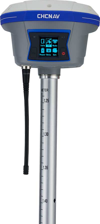
CHC Navigation has released and is immediately shipping its new i90 IMU-RTK GNSS Series receiver. The i90 IMU-RTK GNSS Series is designed to dramatically increase GNSS real-time kinematic (RTK) availability and reliability.

The i90 is powered by the company’s latest inertial measurement unit (IMU) and RTK technology to provide robust and accurate GNSS positioning in any circumstances.

Unlike standard micro-electro-mechanical (MEMS)-based GNSS receivers, the i90 GNSS IMU-RTK combines a high-end calibration and interference-free IMU sensor with a state-of-the-art GNSS RTK engine and advanced GNSS tracking capabilities.

The i90 is designed to increase productivity and reliability of survey projects. No complicated calibration process, rotation, leveling or accessories are necessary with the i90 GNSS Series. Just a few meters’ walk will initialize the i90 internal IMU sensor and enable RTK survey in difficult field environments. The i90 GNSS automatic pole-tilt compensation boosts survey and stakeout speed by up to 20%.

“Our new i90 IMU-RTK GNSS Series is pushing the boundaries of conventional GNSS survey by extending RTK positioning availability and reliability,” said George Zhao, CEO of CHC Navigation. “CHCNAV is the GNSS technology enabler, making high-end GNSS solutions available for every surveyor.”

Publicerad den Lämna en kommentar

Inbjudan till seminarium – Geodata för forskning, utbildning och kulturverksamheter

Lantmäteriet anordnar tillsammans med Sveriges lantbruksuniversitet (SLU) och Kungliga Tekniska Högskolan, KTH ett seminarium som vänder sig till forsknings-, utbildnings- och kulturverksamheter som har tecknat eller önskar teckna avtal för tillgång till geodata.

Nyhet från geodata.se, orginal inlägg

Publicerad den Lämna en kommentar

CEA-Leti and Orolia announce FlexFusion positioning and navigation technology

​Combining data from GNSS and IMUs ensures accuracy during GNSS outages.

Leti, a research institute of France’s CEA Tech, and Orolia have announced a new sensor-data-fusion engine that ensures resilient positioning and navigation even in cases of GNSS jamming or spoofing.

Orolia is a leader in accuracy and performance for terrestrial, aeronautic and naval transportation positioning, navigation and timing applications.

Called FlexFusion, the algorithm technology processes data from GNSS, inertial management units (IMU) and odometers to provide precise positioning in all conditions.


Orolia will present its latest technological developments at ION GNSS+, booth 311, taking place in Miami, Florida, Sept. 17-19.


FlexFusion’s design relies on a modelization of GNSS and IMU (triple-axis accelerometer, triple-axis gyrometer and triple-axis magnetometer) output for synthetic trajectory generation.

The fusion approach exploits Bayesian estimators, such as Kalman filters. The first algorithm was setup on modeling signals, and its optimization relies on an extensive real-life sample database acquired through field test. This process used CEA-Leti’s HYLOC reference platform, which provides a reference positioning of a few centimeters.

More than 100 trajectory samples were collected in urban, suburban, forest and mountain environments with different GNSS outage conditions.

The new positioning technology supports edge artificial intelligence (AI) because the data-fusion algorithm is performed locally to ensure that positioning and navigation information is available locally and is failsafe even in case of jamming or spoofing of GNSS data.

“Recent events have demonstrated that it is possible to change the course of a ship or force a drone to land in a hostile area by simply spoofing GPS signals,” said CEA-Leti CEO Emmanuel Sabonnadière. “The increasing reliance on a GNSS for the execution of military operations and terrestrial, aeronautic and naval transportation requires using positioning and navigation systems that are able to detect GNSS outages and provide resilient position and navigation features.”

A version of FlexFusion that demands less of the CPU implements a loose coupling algorithm that uses GNSS receiver-output positions as entry of the algorithm. An advanced version implements a tight coupling fusion algorithm of GNSS and IMU data that significantly enhances the resilience of positioning and navigation under real-world conditions.

This novel approach enables total control of treatments and filtering applied to raw signals, which increases performance of the fusion. It also improves positioning performance in particular if there are fewer than four GNSS satellites available, or when there are recurrent multi-trajectories, which sometimes occur in urban canyons.

CEA-Leti has licensed the patented FlexFusion algorithm to Orolia.

“Orolia is integrating FlexFusion in a new version of its VersaPNT product, the first compact, all-in-one and resilient positioning, navigation and timing (PNT) system for vehicles and blue force tracking, tactical UAV navigation and marine applications,” said Thierry Delhomme, EMEA general manager, Orolia. “This powerful algorithm helps deliver on the promise of VersaPNT as an always-accurate PNT system that operates in any environment.”

FlexFusion development was supported and partially funded by the Easytech program of IRT Nanoelec, thanks to the French National Program “Programme d’Investissement d’Avenir” ANR-10-AIRT-05.

Publicerad den Lämna en kommentar

U-blox GNSS modules help UAVs carry out life-saving work

The u-blox ZED-F9P, a high-precision GNSS module that delivers centimeter-level accuracy within seconds, has been incorporated into the latest electric Tron F90+ fixed-wing unmanned aerial vehicles (UAVs).

Quantum-Systems, a German company that specializes in electric VTOL (vertical take-off and landing) aircraft for civilian use, manufactures the Tron F90+, which is employed in mission-critical logistical activities such transporting emergency blood reserves to remote locations. Other uses include mining and agriculture-related tasks.


Quantum-Systems and u-blox are both exhibiting at Intergeo in Stuttgart, Germany, Sept. 17-20. Quantum-Systems is at booth K1.074, and u-blox at booth L1.025.


The Tron F90+ has a 3.5-meter wingspan and can travel at speeds of up to 160 km/hour with a 100-km flight range. It is the latest addition to the Quantum-Systems eVTOL UAV platform designed for cargo, inspection, survey and mapping, and reconnaissance in adverse conditions. Other models include the Trinity F9, Scorpion and Vector UAVs, all of which feature u-blox F9 high-precision GNSS technology.

In developing the Tron F90+ UAV, the Quantum-Systems engineering team needed accurate enough position data to ensure that VTOL operations would always go smoothly, and the valuable payloads were protected from damage.

Through the multi-band real-time kinematic (RTK) and raw code and carrier-phase data available to the ZED-F9P, the necessary positioning correction is assured and the pilot can complete even difficult maneuvers. Absolute position accuracy can be brought down to 3-5 centimeters.

Publicerad den Lämna en kommentar

Hemisphere’s all-new OEM boards with next-gen ASIC technology

[SPONSORED CONTENT] Hemisphere GNSS, a leader in high-precision positioning and heading GNSS technology, discusses the rational for developing and bringing to market its all-new Phantom™ and Vega™ OEM boards, powered by next-generation digital and RF ASIC and interference mitigation technology.

Users wanted a low-power, low-cost system in a smaller machine. Responding to customer needs, Hemisphere researched and developed for several years to create the new Phantom and Vega positioning technology that fits into customer applications to make day-to-day work easier.

Hemisphere’s new (Lyra™ II) digital and (Aquila™) wideband RF ASIC designs optimize performance and provide the ability to track and process over 1,100 channels from all GNSS constellations and signals including GPS, GLONASS, Galileo, BeiDou, QZSS, IRNSS, SBAS, and L-Band (Atlas®). Signal support and tracking for AltBOC and BS-ACEBOC, BeiDou Phase 2 and 3, L5, and QZSS/L6 (L6-D and L6-E) are also available.

This new ASIC technology offers scalable access to every modern GNSS signal available. Also, the Lyra II and Aquila ASIC technology provide the foundation for a new GNSS receiver chipset architecture that significantly reduces the number of board components required, thereby reducing complexity, improving reliability, and lowering power consumption.

The powerful technology platform also includes Hemisphere’s new Cygnus™ interference mitigation technology with built-in digital filtering capabilities and spectrum analysis. The new Cygnus technology provides enhanced anti-jamming, interference detection, and mitigation.

Publicerad den Lämna en kommentar

Geodata.se – Nyhetsbrev nr 6 – 2019

Inbjudan till seminarium – Geodata för forskning, utbildning och kulturverksamheter

Vi riktar oss till dig som vill ha svar på följande frågor:

Vad kan jag använda geodata till? Vilka geodata finns tillgängliga för min utbildning, forskning eller min kulturverksamhet? Hur får jag tillgång till geodata? Hur ser villkoren för användning ut? Har min organisation tillgång till geodata?

Här presenterar vi exempel på praktisk användning av geodata, vilka geodata som är tillgängliga och hur du kan använda dessa för forskning, utbildning och kulturverksamhet.

Seminariet vänder sig till forsknings-, utbildnings- och kulturverksamheter som har tecknat eller önskar teckna avtal för tillgång till geodata.

Hur får vi tillgång till geodata?

Genom ett avtal får studenter och forskare vid utbildningsinstitutioner och medarbetare vid kulturinstitutioner tillgång till geodata från ett antal myndigheter. Geodata är digital information som kan kopplas till ett geografiskt läge. Till exempel kartor, flygbilder och laserdata från Lantmäteriet, sjökort från Sjöfartsverket, data om berg och jordarter från SGU samt befolkningsstatistik från SCB.

Arrangörer

Det är Lantmäteriet som nationell samordnare för geodataområdet som bjuder in till seminarium om geodata för forskning, utbildning och kulturverksamheter. Seminariet arrangeras tillsammans med Sveriges lantbruksuniversitet (SLU) och Kungliga Tekniska Högskolan, KTH. I programmet medverkar de myndigheter som erbjuder sin geodata: Statistiska centralbyrån (SCB), Sveriges geologiska undersökning (SGU), Sjöfartsverket och Lantmäteriet.

Tid och plats

  • Tid: 8 oktober 2019, kl. 10.00 – ca 16.00
  • Plats: Kungliga Tekniska Högskolan, KTH, lokal Ångdomen, Osquars backe 31, Stockholm

Anmälan

Anmäl ditt deltagande senast den 20 september 2019 via detta anmälningsformulär.

Detaljerat program kommer att skickas ut i september.

Fika på för- och eftermiddag samt lunch ingår. Seminariet är kostnadsfritt. Det är begränsat deltagarantal eftersom lokalen rymmer max 96 personer. Har ni frågor om seminariet kontakta geodatasekretariatet@lm.se

Välkomna!

Nyhet från geodata.se, orginal inlägg

Publicerad den Lämna en kommentar

ViaLite’s latest GPS splitter designed to save rack space

Photo: ViaLite

Photo: ViaLite

ViaLite’s new Local Integrated GPS Splitter was designed to minimize rack space. Suitable to applications requiring a fan-out of GPS/GNSS signals within a single local area, the unit can accept optical inputs from up to four antennas.

Though it has a height of only one rack unit, the system is suitable for feeding timing and synchronization signals to single or multiple floors or rooms through 8 to 32 optical fiber links with no system loss.

Available with 1×8, 2×8, 4×8, 1×16 and 2×16 options, the easy-to-install GPS Splitter has a 1000-1800-MHz frequency range. Built-in simple network management protocol (SNMP) control is included as well as dual-redundant power supply units.

Typical application areas include data centers, banking institutions, scientific research establishments, cellular test environments, fixed satcom Earth stations and teleports, oil and gas platforms, and big data.

“Our new GPS Splitter was developed in response to customer demand across a wide range of sectors,” said ViaLite Product Manager John Golding. “We are pleased to have been able to meet their needs by providing a very high-quality product at a reasonable cost.”

Publicerad den Lämna en kommentar

Septentrio introduces GNSS/INS system in rugged housing

The AsteRX-SBi has a rugged housing, making it suitable for machine control and other outdoor uses. (Photo: Septentrio)

The AsteRX-SBi has a rugged housing, making it suitable for machine control and other outdoor uses. (Photo: Septentrio)

Septentrio has expanded its GNSS/INS portfolio with the AsteRx SBi, a new housed GNSS/INS receiver. The ruggedized AsteRx SBi fuses high-accuracy GPS/GNSS with a high-performance inertial sensor to provide reliable positioning and 3D orientation for machine control and logistic applications.

Within its rugged, waterproof enclosure, a high-performance GPS/GNSS is coupled with an industrial-grade inertial sensor to provide high-accuracy, reliable positioning and 3D orientation (heading, pitch, roll).

Offering the flexibility of either single or dual antenna, AsteRx SBi is designed for quick and easy integration into any machine monitoring or control system. AsteRx SBi packs performance and durability into a single, compact box. Reliable location and 3D orientation data is streamed with a high update rate and constant low latency.

“AsteRx SBi was designed with ease of integration and reliability in mind. Its compact, ruggedized housing is optimized for easy clamping to any machinery,” said Danilo Sabbatini, product manager at Septentrio. “It has all the features and tools needed for straightforward integration into machines or large robotic systems.”

Septentrio reliable centimeter-level positioning is based on true multi-frequency, multi-constellation GNSS (GPS, GLONASS, Galileo, BeiDou, QZSS) technology. AsteRx SBi combines GPS/GNSS and an industry-grade IMU (inertial measurement unit) to deliver precise positioning together with 3D attitude.

The AsteRx SBi is a robust positioning solution for machinery operating in environments challenging for GNSS. (Photo: Septentrio)

The AsteRx SBi is a robust positioning solution for machinery operating in environments challenging for GNSS. (Photo: Septentrio)

Septentrio’s unique GNSS–IMU integration algorithm enables continuous positioning in environments of low satellite visibility where short GNSS outages are possible. This is referred to as coasting or dead reckoning, and can happen near high structures, under bridges or under thick foliage. This makes AsteRx SBi a robust positioning solution for machinery operating in environments challenging for GNSS, such as in container yards, urban canyons or near cliffs.

AsteRx SBi comes with built-in industry leading Advanced Interference Mitigation (AIM+) technology. In busy urban environments electromagnetic waves can interfere with GPS and GNSS signals. AIM+ offers protection against such interference resulting in faster set-up times and robust continuous operation. A built-in power spectrum plot allows users to analyze interference, helping locate its source and mitigating it.

Publicerad den Lämna en kommentar

Racelogic introduces VBOX Touch GNSS datalogger

VBOX Touch datalogger. (Photo: Racelogic)

VBOX Touch datalogger. (Photo: Racelogic)

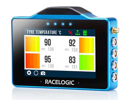
The VBOX Touch from Racelogic is the first in a new generation of highly flexible, enhanced accuracy GNSS dataloggers. The powerful hardware can be used in many types of diverse automotive tests such as acceleration, braking, speed verification, tyre temperature monitoring, lap-timing and durability, according to the company.

The VBOX Touch comes preloaded with a sophisticated performance application that covers many common use cases. Other applications can be downloaded free of charge from the Racelogic online library. Racelogic can also write custom scripts based on customer requirements.

The VBOX Touch has a daylight readable colour touchscreen, 10-Hz GNSS engine, Wi-Fi, Bluetooth, twin CAN ports, serial port, digital input and four multi-color LEDs.

Applications are written in Python script, offering greater flexibility as well as the potential for users to write code to solve their specific testing requirements. If you need a configurable, touchscreen display which can interact with two different CAN buses, log data, know the precise position and speed whilst giving clear feedback to drivers, then the VBOX Touch is for you.

A high-accuracy 2-cm RTK GPS version is available, which uses the latest dual-frequency GPS, GLONASS and Galileo signals to deliver accuracy even under difficult conditions. These new signals significantly increase the RTK resilience near trees and tall buildings, providing precise lap-timing, position triggers and trajectory maps in places where 2-cm GPS has typically not been available.

Founded in 1992, RACELOGIC are based in Buckingham, UK, and have supplied the Automotive industry with reliable and accurate GPS dataloggers for the last 18 years. In the development of the VBOX Touch we have worked closely with our end users to create a powerful tool to help them deliver results faster and more accurately on the test track or open road.