Publicerad den Lämna en kommentar

Trimble’s compact GNSS board gives high-precision positioning to UAVs

The UAS1 GNSS receiver module has been designed for UAV/UAS applications requiring centimeter accuracy in a small package.(Photo: Trimble)

The UAS1 GNSS receiver module has been designed for UAV/UAS applications requiring centimeter accuracy in a small package.(Photo: Trimble)

Trimble has introduced a compact, high-precision GNSS board specifically designed for unmanned aerial systems (UAS).

The Trimble UAS1 has a simple connectivity and configuration to allow UAS system integrators to easily add satellite-based positioning — with the ability to upgrade its capabilities — using rugged connectors and Trimble’s easy-to-use software interface.

The new UAS1 incorporates the latest Trimble Maxwell technology with advances in high-precision GNSS positioning. Its GNSS engine with 336 channels is capable of tracking L1/L2 frequencies from the GPS, GLONASS, Galileo and BeiDou constellations for robust centimeter-level, real-time kinematic (RTK) positioning.

The compact board includes a broad range of receiver capabilities — from high-accuracy GPS-only to full GNSS features for positioning. Firmware options and features are password upgradeable, allowing functionality to be added as requirements change.

The receiver also supports fault detection and exclusion (FDE) and receiver autonomous integrity monitoring (RAIM). System integrators also have the ability to detect interference with the RF Spectrum Monitoring and Analysis tool embedded in the receiver.

“UAS manufacturers demand high performance, reliability and high-quality customized support for their positioning solutions,” said Thomas Utzmeier, general manager of Trimble’s Integrated Technologies Division. “The new UAS1 board delivers the latest GNSS technology in an easy-to-integrate form factor for UAV/UAS applications.”

Designed for easy integration and rugged dependability, the Trimble UAS1 has a Remote Network Driver Interface Specification (RNDIS) that enables manufacturers to access the web UI with the USB connector. As with similar Trimble embedded boards and modules, easy-to-use software commands can simplify integration and reduce development times.

Features also include integrated Trimble RTX technology, an industry-standard camera hot-shoe interface to geo-position photographs, and LED indicators for status checks. The Trimble UAS1 can also output to RINEX, a common postprocessing format.

The Trimble UAS1 supports Trimble CenterPoint RTX GNSS corrections, which enable precise and robust positioning without the use of a base station via a subscription service. CenterPoint RTX allows users to achieve better than 2-centimeter horizontal and 5-centimeter vertical accuracy.

Trimble’s UAS1 is suitable for UAS applications requiring centimeter accuracy in a small package. Manufactured and tested to Trimble’s highest quality standards, the compact design allows for easy setup, configuration and installation in a customers’
system.

Using a full metal shield (the form factor is 71 x 46 x 13 millimeters), the board’s design enables high-precision GNSS signal protection from electromagnetic interference (EMI) on the host UAS platform. In addition, the receiver is FCC- and CE-certified, which speeds compliance for the customer’s overall system and can reduce time to market.
Publicerad den Lämna en kommentar

GPS III Ground System Operations Contingency Program nearing operational acceptance

The Global Positioning System enterprise reached another major milestone on Oct. 21, when the GPS III Contingency Operations Program (COps) successfully connected with the first GPS III satellite on orbit. The COps system will allow the Air Force to operationally command and control the new, more powerful GPS III satellites as well as legacy GPS satellites currently in the constellation. The first GPS III satellite was launched on Dec. 23, 2018.

The GPS III COps program achieved several successes in recent months. First, the program completed final ground control system software testing and verification in May 2019. This was followed by delivery to sustainment and final system test completion in June 2019. After final system test, the Air Force approved installation of COps to command and control legacy operations at the Master Control Station at Schriever Air Force Base in Colorado Springs, Colo., and at the Alternate Master Control Station at Vandenberg, Air Force Base near Lompoc, Calif. In October 2019, the COps program received approval from Air Force Space Command’s Operations and Communications Directorate (A3/6) to enter a trial period. The trial period includes testing COps command and control with the live, on-orbit GPS III satellite, which allows the program office to conduct developmental and operational testing needed to thoroughly verify requirements and functionality of the satellite. The testing aims to confirm readiness for operational acceptance targeted for December 2019 and April 2020 for the GPS III satellite and COps respectively.

The GPS III COps program is managed by the U.S. Air Force Space and Missile Systems Center, Production Corps, Command and Control Systems Division, located at Los Angeles Air Force Base in El Segundo, California. The Production Corps is an 800 plus person team managing 26 programs across the Air Force’s space portfolio.

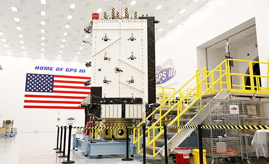
Image provided by Lockheed Martin.

Publicerad den Lämna en kommentar

Taoglas launches Edge Locate for cm-level GNSS positioning for IoT

Photo: Taoglas

Photo: Taoglas

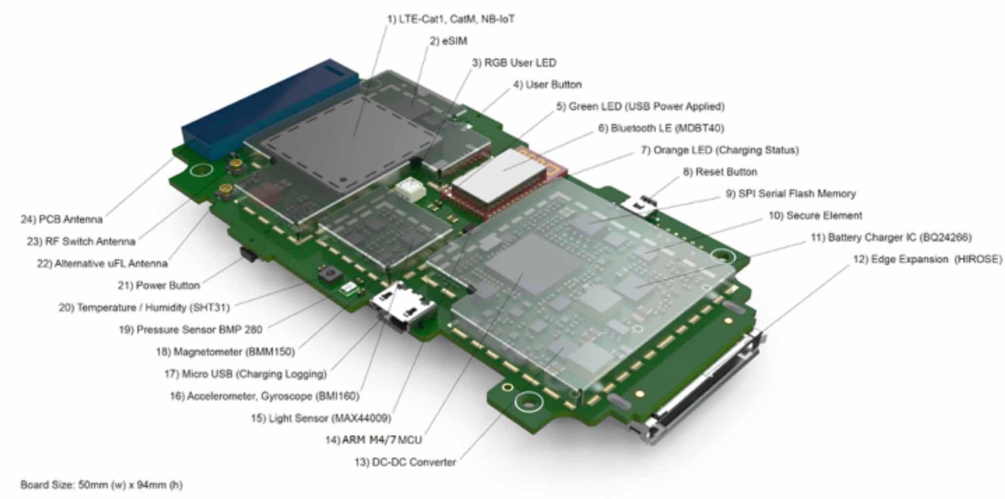
Taoglas, a provider of next-generation Internet of Things (IoT) solutions, has launched Edge Locate, a GNSS L1/L2/E5 module that combines antenna, RF electronics and receiver technology to deliver reliable centimeter-level positioning.

Taoglas, in partnership with u-blox, created a smart antenna that uses multi-band GNSS technology, providing between 1- to 3-centimeter-level accuracy.

With Edge Locate, manufacturers can quickly and effectively build devices with centimeter-level positioning technology, without having to invest in costly and lengthy RF design, integration and testing processes.

The device features multiband GNSS positioning that can be used in conjunction with cost-effective real-time kinematic (RTK) positioning capability.

Traditionally, most IoT devices use single-band GPS technology, delivering on average 10-meter accuracy with existing GPS modules and antennas, Taoglas said in a press release. This enables location-specific, mission-critical services such as emergency response, smart infrastructure, precision agriculture and microbility mobility applications where precise location provides critical value to the IoT application.

Taoglas can also consult and install the RTK network in any global location for any IoT use case.

“Centimeter-level positioning is absolutely key to the next-generation of IoT enabled applications,” said Ronan Quinlan, Co-CEO of Taoglas. “Take an example from the burgeoning micro-mobility industry. When granting licenses from a trial, the city authorities would like to monitor the riders of e-scooters, ensuring riders are staying off footpaths, or parking in designated areas. The problem is that today’s legacy GPS solutions don’t often know which side of the road a scooter is on. Whereas with our solution, fleet operators can pinpoint within just a few centimeters where a device is located. We do this by working with our customers to enable the whole solution and we make sure it works reliably in real life.”

Edge Locate can greatly accelerate the latest GNSS multiband product launch plans by offering a plug-and-play product that uses a common connector for integration into any electronics device. It also connects directly to the Taoglas Edge board for immediately connectivity options.

Taoglas is exhibiting at Mobile World Congress Americas, Booth 2602 in the South Hall of the Los Angeles Convention Center.

Publicerad den Lämna en kommentar

Parkinson questions long delay resolving Ligado issue

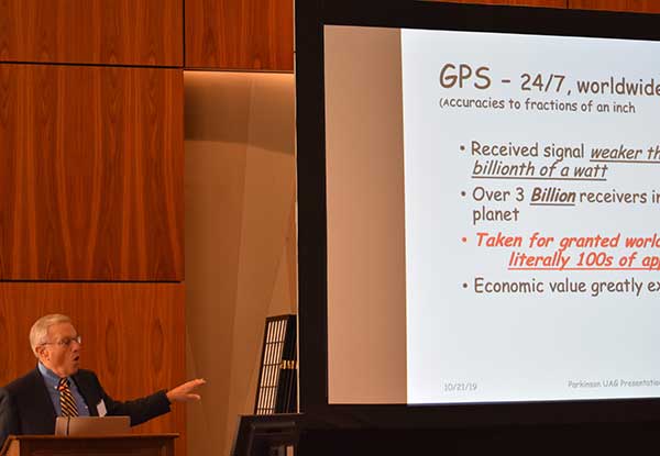
Brad Parkinson called the Ligado proposal “a grave threat to GPS.” (Photo: Dana Goward)

Brad Parkinson called the Ligado proposal “a grave threat to GPS.” (Photo: Dana Goward)

Tells Space Advisory group spectrum issues a concern for all

Speaking to a gathering of space industry leaders, Dr. Brad Parkinson, the original Chief Architect for establishment of the Global Positioning System, outlined the threats to GPS signals posed by a proposal from Ligado Networks that is before the Federal Communications Commission (FCC). The proposal, which was initially approved, has been pending since 2011 over concerns about its impact on reception of GPS signals.

When asked why the proposal has been pending for so long, Parkinson speculated a combination of the enormous sums of money potentially involved and difficulties for the FCC in arriving at an equitable solution were to blame.

“I hope they find some spectrum for Ligado,” he said. “Just not the spectrum they are asking for.” Referring to the powerful proposed transmissions in frequencies adjacent to those used by weak GPS signals, he said “You don’t want to put a rock band next to a retirement home.”


“You don’t want to put a rock band next to a retirement home.”


Parkinson was speaking to the National Space Council’s User Advisory Group (UAG). The UAG was chartered under the Federal Advisory Committee Act in December 2017. Membership includes the CEOs of Lockheed, Boeing and other companies with interests in space, the Governor of Alabama, five former astronauts, and other leaders in space technology and policy.

This was the first time the UAG’s agenda focused on GPS and positioning, navigation, and timing issues. Parkinson was invited to discuss the activities of the U.S. National Space-based Positioning, Navigation, and Timing Advisory Board. The UAG was interested in learning from the PNT Advisory Board’s experience, and about some of the issues it has encountered over the 15 years since its establishment in 2004.

Parkinson used the PNT board’s experience with adjacent band compatibility and the Ligado proposal as an example of a particularly thorny issue. He said the Ligado issue was an ongoing concern that the UAG should share.

Brad Parkinson shared his concerns over lack of Ligado decision with the National Space Council’s User Advisory Group (UAG). (Photo: Dana Goward)

Brad Parkinson shared his concerns over lack of Ligado decision with the National Space Council’s User Advisory Group (UAG). (Photo: Dana Goward)

Also that spectrum issues writ large should be of great concern to all users of space as the competition for spectrum from terrestrial users will continue increase. He called the Ligado proposal “a grave threat to GPS,” especially for aviation and high-precision users.

During the course of the presentation Parkinson asked for the UAG’s support of the PNT Board’s recommendations on the Ligado proposal. He also asked the group to endorse the National PNT Executive Committee’s adjacent band compatibility methodology to any future such proposals.

Parkinson’s presentation concluded with a discussion of how GPS is increasingly being used to support activities in space. It has long been used for booster guidance during the initial phase of space flight.

Relatively recent work using side lobe signals from GPS satellites has caused engineers to recognize a Space Service Volume for GPS. This allows use of the signals for mid-course launch corrections, satellite station-keeping, rendezvous, and potentially trans-lunar navigation.

Parkinson’s presentation is available online.

Publicerad den Lämna en kommentar

Geodata.se – Nyhetsbrev nr 7 – 2019

Inbjudan till Geodataseminarium

Lantmäteriet och Geodatarådet välkomnar till seminarium torsdag den 30 januari kl. 10-15 på Norra Latin i Stockholm. Seminariet fokuserar på samverkan och samhällsnyttor med geodata.

Under dagen får du bland annat ta dela av:

  • Status i Geodatarådets handlingsplan och information om den uppdaterade Nationella geodatastrategin.
  • Hur läget är i Lantmäteriets regeringsuppdrag – Smartare samhällsbyggnadsprocess och den pilot som genomförts under hösten, hur ser tidplanen ut?
  • Du får också ta del av vad slutrapporterna – Grunddata samt Säker och effektivt informationsutbyte, säger och
  • DIGGs erfarenheter och tankar kring förmågan att utför uppdrag i samverkan.

Vi avslutar dagen med inspirerade föredrag samt en gruppdiskussion med frågor som du ger ditt svar på via din mobil. Läs mer och anmäl dig här.

Detaljerade leveransspecifikationer för Geodata-BIM i bygglovsprocessen – Kan Geodata och BIM samspela?

Smart Built-projektet Leveransspecifikationer för Geodata-BIM, vilket även är en ingående del i Geodatarådets handlingsplans aktivitet 3c – Geodata i 3D och relationen geodata-BIM, går nu in i sin avslutningsfas.

Huvudrapporten, de tre arbetspaketsrapporterna, samt bilagor är ute på remiss och ett avslutningsseminarium är inplanerat.

Du som har ett intresse av att få höra mer är Välkommen till projektet Leveransspecifikationer för Geodata-BIMs avslutningsseminarium där vi kommer berätta om projektets resultat, verifierade genom tester, hur dagens ritningsbaserade nybyggnadskarta och situationsplan/planritning/fasadritning/sektionsritning samt relationsritningar kan ersättas med morgondagens digitalt maskinläsbara modeller.

Lite om projektet

Vad har Geodatamodell för nybyggnad, Bygglovsmodell BIM och en ny nationell byggnadsmodell i CityGML gemensamt? Jo, de är samtliga framtagna och praktiskt testade och utvärderade specifikationer inom Smart Built Environment-projektet Leveransspecifikationer för Geodata-BIM.

Projektet har haft möjlighet att göra mer än så; bland annat ta fram testdata för de olika skedena, vilka är fria att användas av systemutvecklare till att testa mottagning och leverans av data enligt leveransspecifikationerna. Det är viktigt att skapa förutsättningar för aktörerna att ta del av digitaliseringens möjligheter!

Projektets genom tester verifierade lösningar, ger förutsättningar att underlätta framtida datautbyte genom enhetliga digitala leveranser av 3D-Geodata och BIM i bygglovsprocessen mellan privata företag, kommuner och myndigheter. Projektets resultat ger förutsättningar att effektivisera och vidareutveckla samhällsbyggandet där digitala geodata och BIM-data behövs och efterfrågas.

Mer precist: Projektets resultat bidrar till effektivisering av plan- och byggprocessen genom att skapa förutsättningar för att ersätta dagens ritningsbaserade leveranser i form av nybyggnadskarta och situationsplan/planritning/fasadritning/sektionsritning samt relationsritningar. Detta leder bland annat till förkortade tider vid bygglovsansökan, säkrare beslutsunderlag samt möjlighet till automatisk uppdatering av geodatabaser.

Välkommen att höra om våra resultat och vad som mer gjorts inom projektet!

Anmälan

Vi möts på Stockholm Waterfront Congress Center, Nils Ericsons Plan 4, 111 64 Stockholm. 

Inbjudan är öppen för alla som har ett intresse av detta, och anmälan stänger senast 2019-11-08. Lokalen har en gräns för antal besökare, så ”först till kvarn”-principen gäller.

Anmälan görs här och är kostnadsfri.

Nyhet från geodata.se, orginal inlägg

Publicerad den Lämna en kommentar

Bentley Systems, Topcon launch Digital Construction Works venture

Bentley Systems and Topcon Positioning Systems have announced that its new, jointly owned company —Digital Construction Works  — is open for business.

Bentley is a global provider of comprehensive software and digital twin cloud services for advancing the design, construction, and operations of infrastructure, and Topcon is a leader in positioning technology for the survey and construction industries.

The companies made the announcement at The Year in Infrastructure Conference, held Oct. 21 in Singapore.

Digital Construction Works has a global staff of digital construction experts and provides digital automation, integration and “twinning” services around a portfolio of fit-for-purpose software and cloud services from Topcon, Bentley, and other software vendors. The venture was created to realize the “breakthrough potential of constructioneering” for industrializing construction, according to a press release.

Bentley Systems and Topcon joined forces in 2016 to jointly develop enhanced integration between their respective MAGNET and ProjectWise cloud services so that engineering and construction workflows could be integrated for improved project quality and performance.

Since then, Bentley and Topcon have continuously introduced innovations in surveying, reality modeling, scheduling and logistics, work packaging, machine control, and progressive assurance for construction.

In 2017, they opened Constructioneering Academies, including at Topcon’s “sandbox” facilities, for construction professionals to experience new digital best practices, first-hand. During 2018, the companies assimilated Bentley’s SYNCHRO and Topcon’s ClearEdge3D acquisitions into constructioneering offerings.

Digital Construction Works is chartered to embed its experts within constructors’ major project teams to advance and optimize constructioneering processes for delivering better design-build outcomes.

Through its digital integration services, to connect and automate constructors’ existing processes with constructioneering, Digital Construction Works can make the best projects better while also helping to institutionalize these digital workflows throughout a constructor’s full project portfolio, the companies said.

At the same time, experiences gained by Digital Construction Works will help guide Bentley Systems and Topcon in prioritizing their constructioneering software development investments.

Digital Construction Works is led by CEO Ted Lamboo, previously senior vice president of strategic partnerships for Bentley Systems, and COO Jason Hallett, formerly vice president of digital construction and business development for Topcon.

Greg Bentley, CEO of Bentley Systems, said, “When we and Topcon recognized the opportunity for constructioneering to finally industrialize capital project delivery, we committed respectively to completing its software requirements. Indeed, our new software capabilities make possible construction digital twins—converging digital context, digital components, and digital chronology. What remains, in going digital for infrastructure construction, is for constructors’ people and processes to take advantage of the technology. We and Topcon have now in turn committed many of our best resources, professionals experienced in both construction and software, to serve shoulder-to-shoulder, in virtual hardhats, to innovatively advance the required digital integration. The Digital Construction Works joint venture has the full management and capital commitments of both our companies, multiplying its unique strengths for helping to realize constructioneering’s potential to close the world’s infrastructure gap.”

Ray O’Connor, president and CEO of Topcon Positioning Systems, said, “What Topcon and Bentley Systems initiated in recent years was done in the spirit of changing mindsets and processes on how we approach construction, and that collaboration has led to the development of this joint venture. The creation of Digital Construction Works perfectly aligns with our focus of helping the industry succeed in meeting infrastructure demands through technological innovations. Through the new organization, companies will have the opportunity to integrate hardware and software capabilities to more quickly and efficiently adopt new technology for more rapid productivity improvements. With customized services to address the individual needs of an organization, widespread adoption and technology improvements can be more readily realized. We are excited to take this journey with Bentley Systems in moving the industry forward.”

Publicerad den Lämna en kommentar

U-blox meter-level positioning technology offers enhanced GNSS for autos

Photo: u-blox

Photo: u-blox

The ultra-robust M9 technology platform will suit demanding automotive and high-end telematics.

U-blox a global provider of positioning and wireless communication technologies, has launched its new ultra-robust meter-level M9 global positioning technology platform, designed for demanding automotive, telematics, and UAV applications.

Because of the high-performance GNSS UBX-M9140 chip, the M9 technology platform and the NEO-M9N (the first module based on the platform) can receive signals from up to four GNSS constellations (GPS, GLONASS, Beidou and Galileo) concurrently. It can achieve high positional accuracy even in difficult conditions such as deep urban canyons, u-blox said in a press release.

The u-blox M9 offers a position update rate of up to 25 Hz, enabling dynamic applications like UAVs to receive position information with low latency. It also features special filtering against RF interference and jamming, spoofing detection and advanced detection algorithms that enable it to report fraudulent attacks quickly so that users’ systems can react to them in a timely fashion.

A SAW (surface acoustic wave) filter combined with an LNA (low noise amplifier) in the RF path is integrated in the NEO-M9N module. This setup guarantees normal operations even under strong RF interferences, such as when a cellular modem is co-located with the NEO-M9N.

“We’ve developed the u-blox M9 as a follow-on from our very successful u-blox M8 GNSS platform, offering even more robust meter-level positioning technology and security features to protect the integrity of applications in the automotive, telematics, and UAV markets,” said Bernd Heidtmann, product manager, Product Strategy GNSS, Product Center Positioning, at u-blox.

Users of the u-blox M9 will benefit from it being part of the wider u-blox product family, which means that developers will be able to design a single PCB and then migrate to a different positioning technology — such as dead-reckoning augmenting GNSS technology — with little change to the board design.

Explorer kit released

U-blox has also released the Explorer Kit M9 (XPLR-M9), a development board for designers who want to assess the technology. The miniature plug-and-play device is supplied with user-friendly u-start software, which includes preset scenarios to enable users to explore the performance of the new device.

The u-blox M9 technology platform complies with the ISO/TS 16949, ISO 16750, AEC-Q100 standards. Engineering samples of the NEO-M9N, the first module based on the M9 platform, the UBX-M9140 high-performance chip, and the Explorer Kit are available now.

To learn more about M9, visit the u-blox booth, Hall South, S.2702, at Mobile World Congress 2019 in Los Angeles, Oct. 22-24.

Publicerad den Lämna en kommentar

Satelles completes funding round for secure PNT platform

Satelles Inc., provider of highly secure satellite-based time and location services, has raised $26 million in Series C funding. C5 Capital led the round, with participation from Iridium Communications and existing investors.

The new investment brings Satelles’s total funding since the launch of its platform to $39 million and will help the company expand its sales and marketing efforts, broaden its partner network, and accelerate product development.

In 2016, Satelles demonstrated sub-microsecond timing using its Satellite Time & Location (STL) service with a stand-alone TCXO-based receiver. In February 2018, the company released new tests using configurations with a differential source and with a more accurate OCXO clock, producing timing accuracy of 160 nanoseconds.

Industry and government requirements for positioning, navigation, and timing (PNT) are expanding at a rapid pace, and the Satellite Time and Location (STL) broadcast signal from Satelles provides assured PNT across a range of applications and at scale.

“Today’s world runs on systems requiring trusted time and location information, and C5 Capital shares our commitment to make it a more secure and better place,” said Michael O’Connor, CEO of Satelles. “We are delighted that C5 led this latest investment round because they bring great insight into cybersecurity, and their international network is unparalleled.”

Attacks such as jamming and spoofing — where a radio transmitter near the target is used to interfere with legitimate GPS or GNSS signals — and hacking are becoming more of a threat because of the key role that GPS and GNSS play in the operation of critical infrastructure.

The STL signal strength is much greater than GNSS because the LEO satellites are much closer. (Slide: Satelles)

The STL signal strength is much greater than GNSS because the LEO satellites are much closer. (Slide: Satelles)

According to the company, the Satelles STL platform brings security to telecommunications networks, financial exchanges, electrical grids, maritime transportation systems, and many other sectors that depend on timing or location information.

Downtime or malfunctions in these systems due to such attacks would be very costly. A June 2019 report sponsored by the National Institute of Standards and Technology estimated a $45 billion loss to the U.S. economy if GPS were to experience a 30-day service disruption.

The Satellite Time and Location broadcast service from Satelles is encrypted to thwart malefactors aspiring to spoof or otherwise disrupt the STL signal, which is delivered via the low-Earth-orbit (LEO) satellite constellation operated by Iridium, an investor in this financing round.

“STL addresses a critical and growing need across many applications and industries, so Iridium’s investment in Satelles aligns with our strategic vision,” said Matt Desch, CEO of Iridium Communications. “Satelles’s technology is unique and powerful, and we are proud to host such an innovative service that solves important problems and leverages the unique capabilities of our network.”

The Iridium satellite constellation-based system offers many advantages:

  • A signal 1,000 times stronger than GPS/GNSS is better at reaching users and facilities in GPS/GNSS-challenged environments such as inside buildings, underground locations, and urban canyons.
  • Overlapping and constantly moving spot beams enable revolutionary cybersecurity solutions that can rely on trusted time and location for authentication and data access.
  • Polar-orbiting, cross-linked satellites ensure truly global coverage.
  • The L-band frequency range allows small, low-cost equipment to receive the Satelles STL signal.

“The capabilities of Satellite Time and Location are enhanced by the technical and service delivery attributes of low-Earth-orbit satellites,” said Dr. Gregory Gutt, President and CTO of Satelles. “An extraordinary constellation such as Iridium’s gives us an incredible platform from which to deliver our trusted PNT solutions, so we remain committed to LEO technologies going forward.”

Commenting on the closure of the Series C investment in Satelles, Andre Pienaar, Managing Partner of C5 Capital, said, “Space is a rapidly developing battleground for cyber threats to critical infrastructure, and GPS is unable to meet all these challenges. Satelles has developed a powerful solution which not only prevents attacks but provides a stronger and more effective service through STL. We are pleased to have led this funding round and look forward to working closely with this remarkable business.”

Publicerad den Lämna en kommentar

OriginGPS and Broadcom introduce L1 + L5 chip at MWC19 Los Angeles

OriginGPS has collaborated with Broadcom to create a new miniature module with L1 + L5 support provided by the BCM47758 chip, enabling ultra-accurate GNSS positioning. The module was developed for solutions requiring super-precision GNSS and a dual-frequency combination.

Photo: OriginGPS

Photo: OriginGPS

The ORG4600-B01 is OriginGPS’ first dual-frequency GNSS module. The module enables customers to build solutions with sub-1-meter accuracy without implementing external components.

Measuring 10 x 10 mm, the ORG4600-B01 module supports L1 + L5 GNSS reception with one RF port, enabling the use of a low-cost, dual-band antenna delivering sub-1-meter accuracy performance in real-world operating conditions.

Alternate Build. An alternate build option allows for separate L1/L5 RF outputs when dual antennas are required. The ORG4600-B01 is suitable for solutions requiring ultra-accurate positioning, such as telematics, the Internet of Things (IoT) and auto OBD applications.

When GPS World reported that dual-frequency chips were about to hit the mass market in December 2018, OriginGPS stated in a press release, it was clear that long-awaited dual-frequency infrastructure support had arrived. ABI Research predicted that dual-frequency chips would account for more than a billion chipset shipments in 2023.

“This year has seen several satellites launched into orbit every month, most of them fitted with L5/E5 capabilities, and the Chinese and European Union governments plan to have their satellite constellations fully operational by 2020.” said Haim Goldberger, CEO of OriginGPS.

Developing the ORG4600-B01 module with the BCM47758 GNSS receiver chip by Broadcom Inc. was the fastest and surest way to add a high-quality dual-frequency module to our portfolio and meet our customers’ increasing requirements for ultra-accurate GNSS modules,” Goldberger said.

“Size is a crucial parameter in GNSS dual-frequency solutions,” said Prasan Pai, product marketing director for the Wireless Communications and Connectivity Division at Broadcom. “The collaboration with OriginGPS has created the industry’s smallest dual-frequency module with ‘no compromise’ quality. For our customers seeking an ultra-accurate GNSS solution in a compact form factor, the ORG4600-B01 fits the bill. The collaboration enables Broadcom to reach new markets, such as precision agriculture, security, children tracking and fleet management.”

“OriginGPS is interested in additional partnerships to enable bringing advanced solutions to market quickly,” said Haim Goldberger, CEO of OriginGPS.

OriginGPS is presenting its products with real-life demonstrations at MWC 2019, Los Angeles, Oct 22-24, Booth S2938.

Publicerad den Lämna en kommentar

Geotab and Ford launch integrated telematics solution

Geotab Integrated Solution for Ford Vehicles offers fleet managers the ability to incorporate Ford vehicle data into the MyGeotab platform for single view of entire fleet. (Photo: Ford)

Geotab Integrated Solution for Ford Vehicles offers fleet managers the ability to incorporate Ford vehicle data into the MyGeotab platform for single view of entire fleet. (Photo: Ford)

Geotab, an IoT and connected transportation company, now offers the Geotab Integrated Solution for Ford Vehicles. Integrating Ford vehicle data into the MyGeotab platform gives fleet managers one dedicated portal with powerful tools to process data from vehicles with an embedded modem as well as those which require a third-party device.

Through this integration, Ford Data Services will securely transfer data from Ford vehicles with a factory installed modem (or Ford Plug-In Modem, where required) to Geotab’s cloud environment, eliminating the need for third-party hardware in Ford vehicles.

A business unit of Ford Smart Mobility, Ford Commercial Solutions help fleets improve their operational effectiveness by offering OEM-grade data verified by Ford engineers such as fuel use and vehicle health alerts. The Transportation Mobility Cloud (TMC), an open platform that securely manages information flow to and from Ford vehicles’ embedded modems, facilitates both new products.

Simplifying the task of mixed-fleet management, the latest solution from Ford and Geotab provides fleet managers with the ability to oversee their entire fleet in one portal while also presenting the added benefit of access to the Geotab Marketplace, a portfolio of mobile apps, hardware add-ons and software add-ins that enable Geotab customers to further customize their fleet management solution.

“Ford Data Services provides the ‘Power of Choice’ so that businesses can get manufacturer-grade vehicle information from the telematics provider of their choice, such as Geotab,” said Michelle Moody, director at Ford Commercial Solutions. “With the launch of Geotab Integrated Solution for Ford Vehicles, fleets are able to access vehicle information such as fuel usage, vehicle health and driver behavior, through the Geotab platform for vehicles with a Ford modem.”

With the solution, fleet managers can access proprietary Ford-specific data available for all Ford 2020 or newer models in the United States.

“The Geotab Integrated Solution for Ford Vehicles will allow fleet managers to benefit from the combination of Geotab’s actionable data insights and powerful rules engine with the rich diagnostic data from Ford’s factory-fitted modem,” said Geotab’s Sherry Calkins, Vice President, Strategic Partners. “This means that regardless of whether they are utilizing an embedded or externally installed telematics solution, the entire fleet can be managed from one platform.”