Publicerad den Lämna en kommentar

Leica lidar sensor improves deep water surveying

Image: Hexagon

Image: Hexagon

Leica Geosystems, part of Hexagon, has launched the Leica HawkEye-5, a new high-performance airborne bathymetric lidar solution for deep water surveying.

Leica’s HawkEye-5 increases survey efficiency by up to 25% compared to previous generations. The technology expands the capabilities of the Leica Chiroptera-5 bathymetric lidar system, enhancing the productivity of applications such as nautical charting, environmental monitoring, and maritime surveillance in deep waters.

The technology is designed to fit the Leica PAV100 gyro-stabilized mount, which isolates the sensor from unwanted aircraft movements — resulting in consistent data density and more efficient area coverage.

The HawkEye-5 combined with the Chiroptera-5 features three lidar sensors, one four-band camera, and a QC camera to collect data from the seabed to land.

The Lidar Survey Studio software suite provides full waveform analysis, automatic data classification and advanced turbid water enhancement to support multiple applications.

Publicerad den Lämna en kommentar

Septentrio launches agnostic corrections program

Image: Septentrio

Image: Septentrio

Septentrio, a leader in high-precision GNSS positioning solutions, has launched the Agnostic Corrections Partner Program.

The program facilitates the use of Septentrio receivers with high-accuracy services that provide varying levels of accuracy, coverage and delivery methods. This also allows users to select the service that suits specific applications and business models.

The Agnostic Correction Partner Program, which includes Polaris from Point One, Skylark from Swift Navigation, and PointPerfect from u-blox, provides documentation for the use of Septentrio receivers with these high-accuracy services.

Agnostic GNSS corrections refer to correction services that are not specific to a particular GNSS receiver or device. It provides correction data that can be used by any receiver that can process the correction signal. Agnostic corrections are useful in situations where multiple types of GNSS receivers are being used, such as in a large-scale surveying project or in a fleet of vehicles that use different types of navigation systems.

Publicerad den Lämna en kommentar

Vietnam collaborates with Thales Alenia Space on SAR solution

Image: Thales Alenia Space

Image: Thales Alenia Space

Thales Alenia Space, along with Viettel and MKE, have been selected by Vinamarine to provide Vietnam with a MEOLUT Next ground station. MEOLUT Next will operate as a part of the COSPAS-SARSAT global medium orbit search-and-rescue (SAR) network.

The SAR solution will enable the detection and location of distress signals from COSPAS-SARSAT beacons on land, in the air, and at sea over a radius of 2,500 km around Haiphong, Vietnam, mainly using signals from Galileo.

Thales Alenia Space’s MEOLUT Next solution employs a phased array antenna and can track more than 30 satellites, which enhances distress beacon detection and expands coverage. The solution can detect and locate distress signals from more than 5,000 km away.

MEOLUT Next is used by other COSPAS-SARSAT users including Canada, the United States, France, the European Union, Togo and Thailand.

Publicerad den Lämna en kommentar

Seen & Heard: Can GPS forecast rain?

“Seen & Heard” is a monthly feature of GPS World, traveling the world to capture interesting and unusual news stories involving the GNSS/PNT industry.


Image: Licence plate, Reviver

Image: Reviver

Digital license plates gone wrong

A security research team has gained administrative access to Reviver, the only company in California that sells digital license plates, which has allowed them to track the physical location of all of Reviver’s customers. With this vulnerability, anyone could remotely update, track and delete someone’s Reviver plate. The access also enabled the researchers to change a section of the text at the bottom of the plate, designed for personalized messages, to anything they want, according to Vice.com. California launched the option to buy a digital license plate in October 2022, and Reviver has since addressed the license plates’ security vulnerability.


AirTag. (Image: David Peperkamp/iStock / Getty Images Plus/ Getty Images)

Image: David Peperkamp/iStock / Getty Images Plus/ Getty Images)

Bill makes secret tracking illegal

Indiana state legislators have filed a bill that would make tracking someone with a GPS-based device without their knowledge a crime, reported WTHR of Indianapolis. The bill is in response to the growing number of criminal cases involving Apple AirTags and other GPS-based tracking devices. Tracking someone secretly is not currently a crime in Indiana; however, laws vary from state to state. Under the proposed bill, the penalty would be increased from a Class C misdemeanor to a Class A misdemeanor if the person tracked is under a protective order. The penalty could be enhanced for someone convicted of using a tracking device when committing a felony. Similar incidents are on the rise around the United States involving the use of AirTags and other tracking devices for criminal purposes.


Image: big-dan/ iStock / Getty Images Plus/ Getty Images

Image: big-dan/ iStock / Getty Images Plus/ Getty Images

Cellphones cause demise

On New Year’s Day, six rockets were launched from a United States-made Himars rocket system at a vocational college in Ukraine, killing at least 89 Russian soldiers. Russia is blaming this on illegal cellphone usage by Russian soldiers, defying a ban. Ukrainian officials say 400 Russian soldiers were killed and another 300 were wounded, contradicting Russia’s report. However, this is the largest number of deaths Russia has acknowledged during the war. Russia says that the obvious cause of the attack was the use of mobile phones, as the enemy was able to locate and determine the troops’ coordinates for the strike. Two of the rockets were shot down before reaching Makiivka in the occupied Donetsk area of Ukraine. 


Image: Angelo F-/ iStock / Getty Images Plus/Getty Image

Image: Angelo F-/ iStock / Getty Images Plus/Getty Image

Can GPS forecast rain?

Researchers at the Department of Marine Geology and Geophysics at the Cochin University of Science and Technology in Kochi, India, say that heavy rainfall can be detected more than six hours in advance using GPS signals, reported The Hindu. During rainy seasons, as GPS signals pass through the atmosphere, how much they are delayed depends on the amount of water vapor present. By using continuous GPS signals and rainfall data collected in Thiruvananthapuram, the study showed that any heavy rainfall could be detected using this delay. 

Publicerad den Lämna en kommentar

Hybrid GNSS+INS sensor: Navigates challenging environments

Image: CHC Navigation

Image: CHC Navigation

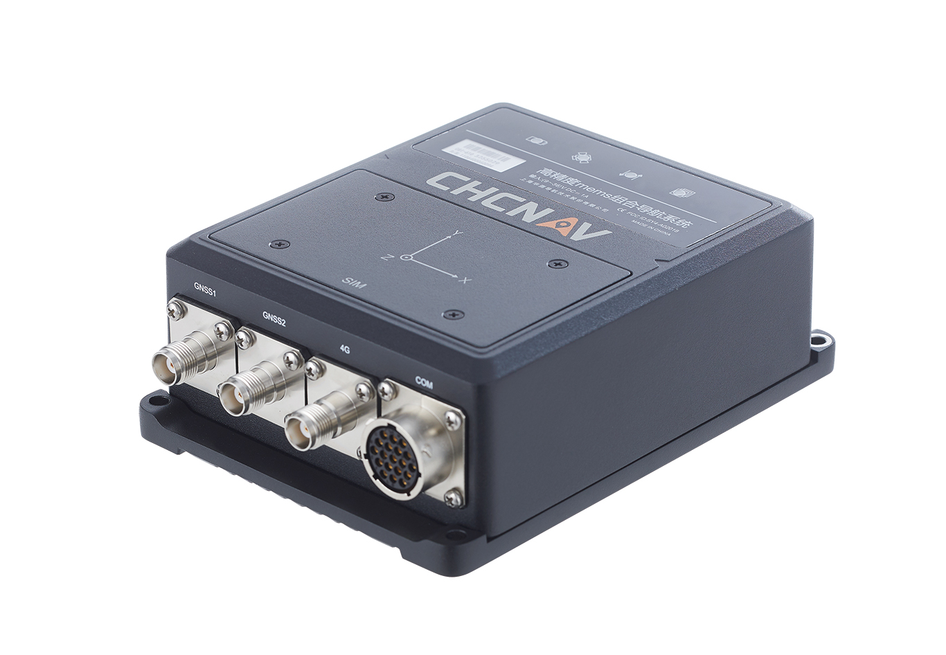
The CHCNAV CGI-610 GNSS/INS sensor is an advanced dual-antenna receiver designed for reliable and accurate navigation and positioning in challenging terrestrial, marine or airborne applications.

Designed to meet the needs of 3D positioning and autonomous vehicle guidance applications, it provides high performance in urban canyons and other harsh environments where GNSS signals are lost or degraded. Incorporating the latest GNSS technology and an industrial-grade inertial measurement unit, the sensor delivers accurate hybrid position, attitude and velocity data up to 100 Hz, driven by CHCNAV algorithms.

Its rugged and lightweight package ensures uninterrupted performance and meets high protection standards.

Publicerad den Lämna en kommentar

BAE Systems and Lockheed Martin tests UAS

Image: Air Force Staff Sgt. Rachel Simones/ Department of Defense.

Image: Air Force Staff Sgt. Rachel Simones/ Department of Defense.

BAE Systems and Lockheed Martin Skunk Works partnered to test the Skunk Works Stalker and Indago UAS on BAE Systems’ amphibious combat vehicle (ACV) command, control, communication and computers (C4)/UAS variant. The UAS will provide reconnaissance capabilities to support U.S. Marine Corps expeditionary warfare and battle management capabilities.

BAE Systems tested the Stalker and Indago UAS — in addition to other technology suppliers — as a part of contractor verification testing. With contractor verification testing complete, the USMC plans to conduct additional tests to evaluate whether the AVC C4/UAS is a solution for the Advanced Reconnaissance Vehicle program.

“By integrating Stalker and Indago on BAE Systems’ ACV platform, we are delivering greater mission flexibility in a small form factor that supports Marine Corps operations,” Jacob Johnson, Skunk Works UAS and attritable systems director, said.

The Skunk Works Stalker and Indago UAS provide a broad operating envelope and endurance, which enables diverse and demanding missions while maintaining a small operational footprint and crew requirement.

BAE Systems’ ACV C4/UAS vehicle is a mobile systems integration lab built to demonstrate the technology Marines need to conduct reconnaissance, surveillance and acquisition capabilities, including the ability to sense and communicate targets over the horizon using C4 systems.

Publicerad den Lämna en kommentar

OxTS product now available with additional features

OxTS Georeferencer 2.5

Image: OxTS

OxTS has released its Georeferencer 2.5 with the anyNAV feature and eight lidar sensors from RoboSense. Georeferencer 2.5 featuring anyNAV software is suitable for survey applications.

Users of Georeferencer 2.5 with anyNAV feature enabled can boresight payloads and georeference lidar data using the user’s navigation data. The anyNAV software enables lidar surveyors to create accurate pointclouds quickly.

Georeferencer 2.5 now takes navigation data from third-party inertial navigation systems, which enables users to use that data to georeference raw lidar data from multiple sensor families. The resulting data can then be viewed in many pointcloud viewer software packages.

Publicerad den Lämna en kommentar

Safran Electronics and Defense releases defense PNT system

NAVKITE on board a vessel. (Image: Safran Electronics and Defense)

NAVKITE on board a vessel. (Image: Safran Electronics and Defense)

Safran Electronics and Defense and Fuscolab, the innovation lab for the French Marine Corps, released a resilient position, navigation, and timing (PNT) system, NAVKITE. It provides navigation integrity and performance over long periods of time and under demanding circumstances on land and at sea.

NAVKITE meets operational requirements for the French Navy Commandos and will be integrated in Embarcation Commando a Usage Multiple Embarquable (ECUME) — a transportable, multirole, semi-rigid boat purpose-designed for commandos and other special forces.

NAVKITE’s capabilities depend on the coupling of Safran’s Geonyx M inertial navigation system with the VersaSync time/frequency server. Together, they handle the transmission of PNT data to ensure mission continuity.

The first sea trials of the system, conducted by Fuscolab and the Ponchardier commando unit, demonstrated NAVKITE’s performance under operational conditions. It was then successfully deployed in February in the joint services exercise Hemex, during phase two of Orion, a large-scale operation for resilient, innovative and interoperable armed forces focused on high-intensity conflicts.

Publicerad den Lämna en kommentar

Sikorsky partners with CMC Electronics for FMS

Image: CMC Electronics

Image: CMC Electronics

CMC Electronics has entered a multi-year contract with Sikorsky, a Lockheed Martin company, to supply its CMA-2082MC military flight management system (FMS) for several Sikorsky helicopter models, including the UH-60M, HH-60M, HH-60W, S-70i and the S-70M.

CMA-2082MC is a complete FMS with integrated radio management, which provides centralized control of navigation sensors, communication radios, mission avionics and more. It is also highly reliable while operating in harsh environments.

The helicopters complete with CMA-2082MC military FMS will be delivered to the U.S. Army and the U.S. Air Force, as well as several Black Hawk customers for use in a wide range of missions including search and rescue, troop transport, medical evacuation, disaster relief, aerial firefighting and border patrol.

Publicerad den Lämna en kommentar

Raytheon completes JPALS delivery to U.S. Nav

Image: U.S. Department of Defense / Raytheon Technologies

Image: U.S. Department of Defense / Raytheon Technologies

Raytheon Technologies has delivered all 23 contracted Joint Precision Approach and Landing Systems (JPALS) low-rate production units to the U.S. Navy to ship to Japan. Raytheon announced the contract with the Navy back in February to provide JPALS to the Japan Maritime Self-Defense Force (JMSDF), which will be deployed on the JMSDF JS Izumo carrier in 2024.

JPALS is a software-based GPS navigation and precision approach landing system that guides aircraft onto carriers and amphibious assault ships regardless of sea state or weather conditions, bolstering safety and operational capability.

JPALS is deployed on all U.S. Navy aircraft carriers and amphibious assault ships, as well as all F-35 aircraft. In addition, JPALS are deployed on platforms from two countries: the UK Royal Navy’s HMS Queen Elizabeth, and the ITS Cavour, an Italian aircraft carrier, to support their F-35 squadrons.

Raytheon has also developed an expeditionary variant of JPALS called eJPALS, which is a smaller, portable system that could be packaged in ruggedized cases, mounted on small vehicles, and deployed in austere, remote locations for precision landings. The system could establish up to 50 different landing points within a 20-nautical-mile radius.