Publicerad den Lämna en kommentar

Cosmic-ray muons navigate underground

Image: Hiroyuki K.M. Tanaka

Image: Hiroyuki K.M. Tanaka

By using muon-detecting ground stations synchronized with an underground muon-detecting receiver, researchers at the University of Tokyo were able to calculate a receiver’s position in the basement of a six-story building without requiring GPS signals. The muometric positioning system (muPS) team was led by Hiroyuki Tanaka.

As GNSS cannot penetrate rock or water, muon technology could be used in future search and rescue efforts, to monitor undersea volcanoes, and guide autonomous vehicles underground and underwater. Muons are fast, subatomic-sized particles that have been used to wirelessly navigate underground.

MuPS was first created to help detect seafloor changes caused by underwater volcanoes or tectonic movement. It uses four muon-detecting reference stations above ground to provide coordinates for a muon-detecting receiver underground.

Early versions of muPS required the receiver to be connected to a ground station by a wire. However, new research uses high-precision quartz clocks to synchronize the ground stations with the receiver. The four parameters provided by the reference stations plus the synchronized clocks used to measure the muons’ “time-of-flight” enables the receiver’s coordinates to be determined. This system is called the muometric wireless navigation system (MuWNS).

To test the navigation ability of MuWNS, reference detectors were placed on the sixth floor of a building while a researcher took a receiver detector to the basement floor. They slowly walked up and down the corridors of the basement while holding the receiver. Rather than navigating in real time, measurements were taken and used to calculate their route and confirm the path they had taken.

The full published study can be found here.

Publicerad den Lämna en kommentar

OEMs take tech to the next level

OEM products are vital to many industries. Companies such as Septentrio and SBG Systems design and produce a variety of OEM devices for many different applications. (Image: sankai/E+/Getty Images)

OEM products are vital to many industries. Companies such as Septentrio and SBG Systems design and produce a variety of OEM devices for many different applications. (Image: sankai/E+/Getty Images)

OEM devices are an integral part of many applications requiring precise positioning technology. As the OEM market grows and performance requirements become more demanding, it is critical for OEM devices to be reliable, accurate, and easy to integrate. From precision agriculture, to surveying and mapping, to UAV missions, there are OEM devices on the market suitable for demanding applications.

Survey and Map Like a Pro

Surveying and mapping is one area in which OEM boards are embedded deep in many products. Septentrio designs and manufactures multi-frequency, multi-constellation, GPS/GNSS positioning technology and offers a variety of OEM products for demanding applications.

Image: Septentrio

Image: Septentrio

The AsteRx-m3 Pro is an ultra-low power GNSS rover receiver. It is compact and high-performance, making it suitable for integration into high-precision industrial applications. It incorporates multi-frequency, multi-constellation GNSS technology as well as anti-jamming algorithms for availability and reliability. The AsteRx-m3 Pro features AIM+ advanced anti-jamming and anti-spoofing technology as a part of Septentrio’s GNSS+ Technology Suite.

This receiver is designed for rover (mobile) applications, making it an easy-to-integrate solution for any kinematic application where reliable high-accuracy positioning is needed. It is available in single or dual antenna mode, for high quality heading and pitch, or heading and roll information.

GNSS heading is available directly from initialization and removes reliance on vehicle dynamics or magnetic sensors. This is an optional feature.

“Septentrio OEM receivers come in a variety of form factors, from compact modules to credit-card boards,” Danilo Sabbatini, OEM product manager at Septentrio, stated. “Our multi-frequency OEM receiver portfolio includes products that fit various user needs from purely rover GNSS high accuracy positioning to heading receivers, as well as GNSS/INS boards for inertial navigation or mapping.”

Image: Septentrio

Image: Septentrio

Aside from surveying and mapping, the AsteRx-m3 Pro is suitable for assured position, navigation and timing (PNT), autonomous vehicles, precision agriculture, logistics and port operations, mining and construction, rail, robotics, space and UAV applications.

Plowing the Way

The increase in demand for food due to population growth challenges farmers to increase production. To help them do this, Septentrio is working with manufacturers of agricultural machinery to enable them to achieve centimeter-level positioning accuracy.

Image: Septentrio

Image: Septentrio

The AsteRx-i3 D Pro is a ready-to-use GNSS/INS single-board receiver that delivers reliable centimeter-level positioning combined with 3D orientation (heading, pitch and roll) in demanding environments. Its inertial sensor provides orientation and positional dead-reckoning, making it suitable for systems that require continuous positioning even during short GNSS outages. It provides reliable and accurate positioning by enhancing GNSS with an inertial measurement unit (IMU).

Image: Septentrio

Image: Septentrio

The AsteRx-i3 D Pro is quad-constellation and multi-frequency. It provides all-in-view real-time kinematic positioning and features AIM+ unique interference monitoring and mitigation system and other advanced GNSS+ algorithms.

Like the AsteRx-m3 Pro, the AsteRx-i3 D Pro is also suitable for assured PNT, autonomous vehicles, logistics and port operations, mining and construction, rail, robotics, space, survey and mapping, and UAV applications.

For more information about Septentrio’s OEM boards, click here.

Flying High

SBG Systems has released Ekinox Micro, a compact and rugged high-performance inertial navigation solution designed to deliver accuracy in challenging environments. Ekinox Micro combines a high-performance MEMS tactical inertial sensor with a quad-constellation, dual-antenna GNSS receiver, making it suitable for mission-critical applications.

Image: SBG Systems

Image: SBG Systems

GPS World caught up with Yoann Plénet, head of products at SBG Systems, at AUSVI XPONENTIAL in May. He elaborated on Ekinox Micro’s key markets and features.
“This is Quanta Micro in a box with the same performance and the same benefits that you get [with the Quanta Micro]: inertia, enhanced GNSS, and complement[ing] the GNSS,” Yoann said. “At the same time, we are targeting very rough environments, especially larger drones which are most likely military ones. So, [Ekinox Micro] is a very rugged product.”

Ekinox Micro includes pre-configured motion profiles for land, air and marine applications, enabling the sensor and algorithms to be tuned for maximum performance in any condition. The device is designed for ease of use and integration, with simple connectors, a web configuration interface, a datalogger, Ethernet connectivity, a PTP server, a REST API for configuration, and multiple input and output formats.

Image: SBG Systems

Image: SBG Systems

Ekinox Micro is compatible with real-time kinematic (RTK) and based on a tactical 0.8°/h class inertial measurement unit calibrated across the entire operating temperature range. It features accuracy roll/pitch of 0.015°, accuracy heading of 0.035°, and accuracy position of 1.2 m without any corrections or 1 cm in RTK.

Yoann also said that with the rise of jamming and spoofing, Ekinox Micro is designed with enhanced technology to mitigate those threats.

“Jamming and spoofing is ongoing and is an issue for more and more of our clients. So, we have worked a lot — and that is something that is beneficial to all of our product ranges — on enhancing our algorithms and our technology so we can better detect jamming and spoofing than we could before,” Yoann said.

Ekinox Micro will be commercially available in September. Click here for more information on Ekinox Micro.

Bonus Device

Image: Septentrio

Image: Septentrio

The Septentrio mosaic-X5 is a multi-band, multi-constellation GNSS receiver in a low power surface mount module with a wide array of interfaces. It is designed for mass market applications such as robotics and autonomous systems — capable of tracking all GNSS constellations, supporting current and future signals.

The mosaic-X5 has an update rate of 100 Hz, is easy to integrate, and is optimized for automated assembly.
Antoon De Proft, Septentrio’s CEO, mentioned in the April 2023 issue of GPS World the company’s innovation in Leuven, Belgium.

“Septentrio’s 20 years of experience in GNSS technology as well as our strategic partnership with the European Space Agency and close collaboration with the IMEC semiconductor technology hub has enabled us to produce the mosaic-X5 receiver,” he said. “This compact module is one of the highest performing and resilient GNSS receivers on the market. It is used in a wide array of applications, especially where the position is mission critical. Examples include a wide variety of autonomous devices, including drones that benefit from mosaic’s lightweight and low-power design.”

Francois Freulon, head of product management, added, “Reliability and resilience to GNSS vulnerabilities is a key pillar on which we base our receiver design. RF interference in the form of jamming and spoofing* is increasingly common, which is why we are investing heavily in securing our receivers at the core with the latest hardware and software techniques. In addition to the AIM+ patented technology, the mosaic module already includes OSNMA functionality, which will offer end-to-end authentication on Galileo’s civilian signals, protecting receivers from GNSS spoofing attacks.”
For more information about Septentrio’s mosaic GPS/GNSS modules, click here.

Publicerad den Lämna en kommentar

Flying cars

The U.S. government has visibly and physically conveyed its interest in getting air taxis into operation, through a visit of 70 people — attached to the newly formed Advanced Air Mobility (AAM) Coordination group — to Archer Aviation. The group talked with the executives of the company developing the “Midnight’ air-taxi aircraft and watched a flight test.

The AAM group includes members from leading government agencies concerned with making and keeping this segment of aviation successful, including the Federal Aviation Administration (FAA), the Department of Transportation (DOT), the National Aeronautics and Space Administration (NASA), the Department of Defense (DOD) and other agencies.

AAM group visits Archer Aviation. (Image: Archer Aviation)

AAM group visits Archer Aviation. (Image: Archer Aviation)

Gathering the views of Archer and other electric vertical takeoff and landing (eVTOL) developer executives should be an essential part of the AAM group’s information collection task. And while it’s great to see that the interagency group has every intention of promoting the AAM concept of air taxis, it would perhaps be better if the group also had access to representatives of manufacturers, developers, and those with UAS experience. It’s clear that we need to start by spreading the word, but also by including people in the group who have dedicated themselves to bringing these capabilities to market — that may make the process more efficient.

Along the way, it may also help to understand that the processes we have used in the past to get airframes like this into passenger carrying operations might not work well with this new industry. It’s understandable that it should take a lengthy period to assess, verify, qualify and certify such vehicles in the name of safety, but if companies run out of cash and fold in the interim — which is highly likely with this “start-up industry” — then shouldn’t we be looking for a better way to get these guys off the ground?

No one wants safety to be sacrificed, but could there be some way to streamline, speed up, or simplify the process without skipping essential steps — a way to get new technology into use before it’s obsolete, or a lack of start-up money dooms its progress? The forecast for the economy in the near future is in the billions of dollars. So, providing funding to improve the current processes does make sense. DOD has started to put serious effort into speeding up its acquisition process and has empowered the Defense Innovation Unit (DIU) to find quicker ways to bring commercial technologies into defense.

The processes used to bring new technologies into use are tried and proven, but they are lengthy. In defense, if our opposition can field things quicker than we do, they have an edge in strategy, tactics and a higher probability of winning in battle. These countries are using the same approaches in the commercial world too, and we need to be wary that they may also have a greater chance of winning the “economic war.”

Nevertheless, Archer in California and others such as Joby, also in California, and Liliam in Germany, plod on through varying stages of FAA and European Union Aviation Safety Agency (EASA) certification paths. An example of the effort that a company has been required to put into fulfilling the requirements of a certification agency is that of Lilium, which first applied for its Design Organization Approval (DOA) in 2017, is still churning through the qualification efforts and does not expect approval until 2025. Of course, the answer is “Don’t get on the certification ‘hamster-wheel’ unless you can stand the journey.” However, we do want these systems and vehicles to make it in order to overcome some of the traffic nightmare that we are living through in our major cities and to contribute to the growth in the economy.

Meanwhile, the great hope (even expectation) of the “flying car” is being kept alive by Doroni in Miami with its two seat H1 eVTOL. Having largely burnt through its $3.6 million StartEngine launch money, Doroni is looking for its second round of funding to build more prototypes and join the certification race. However, other single seat eVTOL flying cars have taken the easier route to certify under the FAA Ultralight category.

Doroni H1 prototype. (Image: Doroni)

Doroni H1 prototype. (Image: Doroni)

The H1 has semi-autonomous capability, which Doroni claims will make its eVTOL easy to fly, and allow general sales to any car driver. With air bags, an aerodynamic fuselage — which generates lift — 10 independent propulsion systems (four double prop ducted fans and two forward thrust props), an airframe that can behave as a parachute and “dissipate energy” in case of a crash, and landing gear, the H1 also has multiple independent batteries — all aimed at safety, which will help make it through certification verification. So, if you happen to have the $250,000 proposed sale price and are willing to wait on the completion of FAA certification, you could own your own “flying car.”

Doroni just announced that they have already made 50 test flights within their manufacturing facility along that test and qualification road.


Meanwhile, Ryse Aerotech in Ohio, recently demonstrated a manned test flight of its single seat Recon eVTOL — billed as an aid to farmers, with a top speed around 58 mph, a range of about 25 miles and with the right FAA clearance it could even reach an altitude of 700 ft — an airborne ATV for inspecting crops and the like.

Recon manned test flight in June 2023. (Image: Ryse Aerotech)

Recon manned test flight in June 2023. (Image: Ryse Aerotech)

The path to market that Ryse has selected, however, should see more vehicles in earlier use than Doroni’s H1. All you may need is a driver’s license to take off in a Recon because it’s qualified as an Ultralight craft — just buy and fly. Beware, you cannot fly anywhere near an airport or after dark. FAA has restrictions on Ultralight craft.

So, progress on the semi-autonomous “flying-car” front and a plea to consider the economic benefits and to look to how to improve the efficiency of the existing certification process — not a request to cut corners, rather a request to speed up the processes and save this start-up industry before it goes broke.

Publicerad den Lämna en kommentar

Trimble Terra Office workflow integrates with Esri ArcGIS Pro

Image: Trimble Geospatial 

Image: Trimble Geospatial

Trimble has released the Trimble Terra Office add-in for Esri ArcGIS Pro. The add-in is a part of Trimble’s Terra Office suite of desktop solutions for integrating Trimble TerraFlex field data collection software with GIS systems of record.

With a streamlined user interface, the new Terra Office add-in for ArcGIS Pro enables users to connect TerraFlex workflows directly to the ArcGIS platform from within ArcGIS Pro — Esri’s desktop GIS application. ArcGIS Pro users can now create and manage TerraFlex geospatial data collection projects without leaving ArcGIS.

Organizations that collect data in TerraFlex and bring it into ArcGIS through the add-in can also use the Trimble Offline GNSS Corrections service, for situations where real-time correction services are intermittent or unavailable. With this service, all data from the field is automatically processed in the cloud without user intervention, and the most accurate real-time or post-processed position is stored for each feature and made available for download through the Terra Office add-in for ArcGIS Pro.

For more information on the Terra Office add-in and its availability, click here.

Publicerad den Lämna en kommentar

Launchpad: Mobile mapping, timing modules and UAVs

A roundup of recent products in the GNSS and inertial positioning industry from the July 2023 issue of GPS World magazine.


TIMING
Image: Hexagon

PTP Firmware
To synchronize accurate time from GNSS

The 7.09.00 firmware with a precise timing protocol (PTP) feature enables users to synchronize accurate time from GNSS with other devices and sensors on a shared network. The 7.09.00 firmware’s PTP feature brings stable timing to a user’s other sensor systems connected through a local network to best support positioning, navigation and timing (PNT) and automotive and autonomous applications. The firmware includes SPAN GNSS+INS technology improvements — including a secondary INS solution for built-in redundancy and reliability in challenging conditions. The enhancements are available on all OEM7 cards and enclosures, including all PwrPak7 and CPT7 enclosure variants. The 7.09.00 firmware also features improvements to the time to first fix, a secondary SPAN solution for a more accurate and reliable GNSS+INS output and more. The 7.09.00 firmware is not for precision agriculture applications and is not supported on NovAtel’s SMART antenna products.
Hexagon | NovAtel, novatel.com

Image: Furuno

Timing Antenna
A multi-GNSS and high-performance device

The AU-500 antenna is suitable for time synchronization applications. It supports all constellations in the L1 and L5 bands, including GPS, QZSS, GLONASS, Galileo, BeiDou, and NavIC. A built-in noise filter eliminates interference in the vicinity of 1.5 GHz caused by 4G/LTE mobile base stations as well as other radio waves that can adversely affect GNSS reception. The antenna is equipped with lightening protection and features a high-quality polymer radome that prevents snow accumulation. It is also waterproof and dustproof in compliance with IP67. The AU-500 achieves the best performance in time accuracy and robustness fundamental in critical infrastructure, when combined with Furuno’s GNSS receiver, GT-100. The antenna will be available this month.
Furuno, furuno.com
The u-blox NEO-F10T (Image: u-blox)

Timing Module
Dual-band and secure for 5G communications

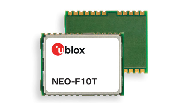
The NEO-F10T offers nanosecond-level timing accuracy, meeting the stringent timing requirements for 5G communications. It is compliant with the u-blox NEO form factor (12.2 mm x 16 mm), allowing space-constrained designs to be realized without the need to compromise on size. The NEO-F10T is the successor to the NEO-M8T module, providing an easy upgrade path to dual-band timing technology. This allows NEO-M8T users to access nanosecond-level timing accuracy and enhanced security. Dual-band technology mitigates ionospheric errors and greatly reduces timing errors, without the need of an external GNSS correction service. Additionally, when within the operational area of a satellite-based augmentation system (SBAS), the NEO-F10T offers the possibility to improve the timing performance by using the ionospheric corrections provided by the SBAS system.
The NEO-F10T supports all four GNSS and L1/L5/E5a configurations, simplifying global deployments. It includes advanced security features such as secure boot, secure interfaces, configuration lock and T-RAIM to provide the highest-level timing integrity and ensure reliable, uninterrupted service.
u-blox, u-blox.com


MOBILE
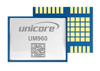
Image: Unicore Communications

Image: Unicore Communications

GNSS RTK Module
A high precision module for multiple applications

The UM960 module can be used for a wide range of applications, such as robotic mowers, deformation monitoring, UAVs, handheld GIS, and more. It features a high position fix rate and provides accurate and reliable GNSS positioning data. The UM960 module supports BDS B1I/B2I/B3I/B1c/B2a, GPS L1/L2/L5, Galileo E1/E5b/E5a, GLONASS G1/G2, and QZSS L1/L2/L5. The module also has 1,408 channels. In addition to its small size, the UM960 features low power consumption — less than 450 mW. The UM960 also supports single point positioning and real-time kinematic (RTK) positioning data output at 20 Hz.
Unicore Communications, unicore.euTualcom
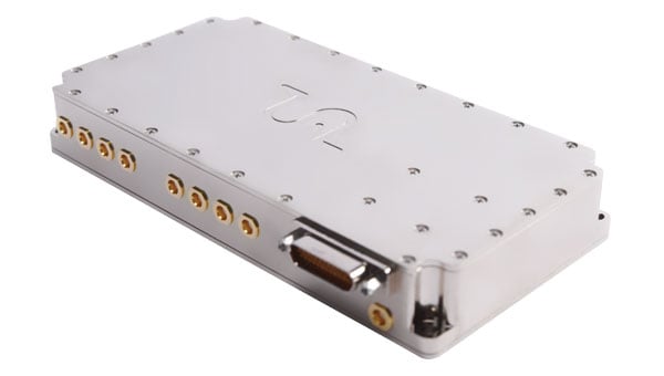
CRPA System
A GPS/GNSS anti-jamming system

This system eliminates interference by applying novel beam forming techniques. With an 8-array CRPA antenna, the system can assure the normal operation of a GNSS receiver in the presence of multiple jamming sources. The anti-jam GNSS CRPA system can be deployed using various configurations and operates with civil and military GPS receivers for land, sea, air platforms (including unmanned aerial systems), and fixed installations. The device has an embedded GNSS receiver that supports all satellite constellations. The device is lightweight and compact. It requires minimal integration training and easily integrates into new or legacy platforms. The antenna also offers assured positioning, navigation and timing.
Tualcom, tualcom.com

KP Vehicle Antenna

IoT Antennas
Rugged and designed to enhance connectivity

KP Performance Antennas’ internet of things (IoT) multiband combination antennas are designed to enhance connectivity for vehicle fleets and base stations. The IoT multiband combination antennas have dedicated ports for cellular, Wi-Fi and GPS bands. They are also indoor and outdoor IP69K rated and can withstand harsh environmental conditions, such as extreme temperatures, water and dust. The antennas are suitable for transportation emergency response and agriculture applications. The IoT multiband combination antennas are in-stock and available now.
KP Performance Antennas, kpperformance.com

Image: Tallysman Wireless

Smart Antennas
With integrated technology for centimeter-accuracy

PointPerfect PPP-RTK augmented smart antennas combine the ZED-F9R high precision GNSS and the NEO-D9S L-band receivers from u-blox and Tallysman Accutenna technology. The multi-band (L1/L2 or L1/L5) architecture removes ionospheric errors, and the multi-stage enhanced XF filtering improves noise immunity while relying on the dual-feed Accutenna element to mitigate multi-path signal interference rejection. Some versions of the new smart antenna solutions include an inertial measurement unit (for dead reckoning) and an integrated L-band corrections receiver to ensure operation beyond terrestrial network reach. The PointPerfect GNSS augmentation service is now available in North America, Europe and parts of Asia Pacific.
Tallysman Wireless, tallysman.com/u-blox, u-blox.com


SURVEYING & MAPPING

Photo:

Airborne Laser Scanner
Suitable for mapping applications

The compact and lightweight VQ-580 II-S meets the increasing requirements of compact laser scanners for medium- and wide-area mapping as well as for corridor mapping. The successor of the VQ-580 II airborne laser scanner, provides a maximum measurement range of 2.45 m. It can be integrated with gyro-stabilized mounts as well as into the VQX-1 Wing Pod. It features high accuracy ranging based on waveform-lidar technology. The VQ-580 II-S also has a mechanical and electrical interface for inertial measurement unit (IMU)/GNSS integration.
RIEGL, rieglusa.com

Photo:

Tablet and GNSS Solution
For surveying applications

The RT5 rugged tablet data collector and the RTk5 GNSS solution, which integrate the form factor of the RT5 with real-time kinematic GNSS performance, are suitable for land surveyors, engineers, GIS professionals, and users in need of advanced GNSS positioning with an RTK rover. The RT5 is designed for surveying, stakeouts, construction layout and GIS mapping, and is bundled with Carlson SurvPC — the Windows-based data collection program. The RT5 can run SurvPC with Esri OEM for use in the field. The RTk5 adds an advanced GNSS solution to the RT5, enabling accuracy in a compact, light and versatile package. It comes with a custom-built pole and cradle, a survey-grade antenna, and a small portable helix antenna for handheld GNSS use.
Carlson Software, carlsonsw.comDJI Enterprise

Lidar and RGB Solution
Suitable for aerial surveying

The Zenmuse L1 integrates a Livox lidar module, a high-accuracy inertial measurement unit (IMU), and a camera with a 1 in CMOS on a 3-axis stabilized gimbal. When used with Matrice 300 real-time kinematic (RTK) and DJI Terra, the L1 forms a complete solution that gives users real-time 3D data, capturing the details of complex structures and delivering highly accurate reconstructed models. Users can render centimeter-accurate reconstructions with the high-accuracy IMU, a vision sensor for positioning accuracy, and the incorporation of GNSS data. The solution’s IP54 rating allows the L1 to be operated in rainy or foggy environments. The lidar module’s active scanning method enables users to fly at night.
DJI Enterprise, enterprise.dji.com

Mapping Platform
Real-time, crowd-sourced map data

CityStream Live is a real-time mapping (RTM) platform that enables the mobility industry — including connected vehicles, maps, mobility services, digital twins or smart city applications — to access a continuous stream of crowdsourced road data. This platform provides real-time data on nearly every road across the United States at a reduced cost. Utilizing a crowdsourcing network and artificial intelligence software, CityStream Live offers users and developers a live data feed to increase situational awareness, enhance driving capabilities, increase safety and more. By combining massive data aggregation with real-time data curation, CityStream Live is the first platform to deliver road data streams in real time and at scale, supporting several urban and highway use cases.
Nexar, us.getnexar.com
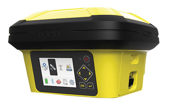
Leica iCON gps 160 (Image: Leica Geosystems)

Leica iCON gps 160 (Image: Leica Geosystems)

Smart Antenna
Contains features that increase productivity on construction sites

The iCON gps 160 is a versatile solution for various applications. It can be used as a base station, as a rover or for machine guidance. The device is a modernization and enhancement of the successful Leica iCON gps 60, which has been well accepted in the market. The result is a smaller, more compact GNSS antenna with additional features and a larger display for ease of use. The Leica iCON gps 160 is particularly suited to complex construction environments with different GNSS requirements because the ability to switch between the different applications is at the users’ fingertips. Besides checking grade, cut and fill, stakeout points and lines, users can also benefit from using this solution for basic-level GNSS machine guidance. It has an integrated color display, a user-friendly interface, smart setup wizards and an intuitive construction-specific workflow to help contractors get the most out of their investment from day one. Size and weight reductions make the iCON gps 160 easy to handle, while the latest GNSS and communication technologies improve data reception.
Leica Geosystems, leica-geosystems.com


UAVPhoto:

Positioning Solution
For UAV delivery applications

The PX-1 RTX is designed for accurate, robust positioning and heading for commercial UAV delivery applications. This solution enables UAV integration companies to add precise positioning capabilities so operators can plan and execute takeoff, navigation and landing tasks as UAV delivery advances to take on more challenging operations. The PX-1 RTX leverages CenterPoint RTX corrections and small, high-performance GNSS-inertial hardware to provide real-time, centimeter-level positioning and accurate inertial-derived true heading measurements. This solution allows operators precise control of UAVs during takeoff and landing to tackle more demanding operations in tight or partially obstructed spaces. It also minimizes operational risks from poor sensor performance or magnetic interference by ensuring greater positioning redundancy, which is especially important as commercial UAV delivery operations venture into difficult urban and suburban environments.
Trimble Applanix, applanix.com

Certification Reference Guide
A guide for the AAM industry

Business and government leaders, engineers, members of the media and any user with an interest in the future of flight can use the Honeywell State of UAS and UAM Certification Guide to help navigate and communicate the complexities of vehicle certification and operational approval across multiple vehicle segments. Industry professionals can access the living document online at aerospace.honeywell.com/us/en/products-and-services/industry/urban-air-mobility. The certification reference guide summarizes evolving Federal Aviation Administration and European Union Aviation Safety Agency rules across multiple advanced air mobility (AAM) segments. It also links to documents that AAM professionals can reference to better understand detailed certification requirements.
Honeywell Aerospace, aerospace.honeywell.com

Photo:

Image: A2Z Drone Delivery

Delivery UAV
Suitable for aerial mapping, UAV inspection, forestry services, search and rescue operations, water sample collection, offshore deliveries, mining, and more

The RDSX Pelican leverages a hybrid vertical takeoff and landing (VTOL) airframe with no control surfaces to combine the reliability and flight stability of a multirotor platform, with the extended range of a fixed-wing craft. With no ailerons, elevator, or rudder, the Pelican’s durable design eliminates common points of failure and extends operational time between maintenance overhauls. Designed to meet the 55 lb takeoff weight limitation for Federal Aviation Administration Part 107 compliance, the Pelican can carry payloads of 5 kg on missions up to 40 km, roundtrip. The Pelican can be optimized for extended range operations or to deliver payloads from altitude with the company’s RDS2 UAV delivery winch. Available in multiple configurations, the RDSX Pelican can be customized for an array of missions. The Pelican enables deliveries from altitude where spinning propellers are kept far from people and property, mitigating consumer privacy concerns of low-flying UAVs while abating intrusive rotor noise. Alternatively, for missions in which the UAV can safely land at its destination, a simple servo-release mechanism can release payloads and expand the Pelican’s payload capacity.
A2Z Drone Delivery, a2zdronedelivery.com

UAS
Suitable for mapping applications

The Trinity Pro UAS features Quantum-Skynode autopilot, using a Linux mission computer. This provides additional onboard computing power, increased internal storage, versatility and interoperability. Included in the Trinity Pro system is QBase 3D operations software. As the Trinity Pro is built on the Trinity F90+ UAS, its new capabilities include planning functions for missions requiring takeoff and landing at different locations, allowing for efficient and safe long corridor flights and beyond visual line of sight operations. The platform also incorporates advanced self-diagnostics to ensure safe operation. The UAS now includes an enhanced terrain- following system. Additionally, improvements to trigger point calculations results in improved image overlap and higher data quality. The Trinity Pro features automatic wind simulation for crash avoidance in bad weather and a linear approach for landing. The UAS is equipped with a downfacing lidar scanner that provides highly accurate ground avoidance and landing control. The system features USB-C ports for faster data transfer. The Trinity Pro is protected against dust and water damage and features increased wind limits of up to 14 m/s in cruise mode and 11 m/s during hover.
Quantum Systems, quantum-systems.com

Publicerad den Lämna en kommentar

Inertial Labs awarded GSA schedule contract

Inertial Labs logo

Inertial Labs has been awarded a General Services Administration (GSA) Multiple Award Schedule (MAS) contract. With the contract in place, federal, state and local government agencies will gain streamlined access to Inertial Labs’ products and services.

The GSA Schedule contract aims to simplify the procurement process, allowing government entities to acquire solutions for navigation, positioning and motion-sensing systems. The products and services offered by Inertial Labs cater to a wide range of applications, including unmanned systems, defense, aerospace, transportation and more.

“We are extremely proud to have been awarded a GSA Schedule contract,” Jamie Marraccini, CEO of Inertial Labs said. “We look forward to supporting the critical missions of our government partners and providing them with the advanced technology they require.”

Publicerad den Lämna en kommentar

Burning ring of fire: Mapping high ocean temps off Florida coast

The ocean off the Gulf of Mexico is undergoing a marine heat wave that could pose a threat to coral reefs, as water temperatures reach 90°F. A coral reef watch map, provided by the National Environmental Satellite, Data, and Information Service of the National Oceanic and Atmospheric Administration (NOAA), shows that the water near the Florida Keys is significantly higher than usual, which causes coral bleaching and other marine life concerns.

Image: NOAA

Image: NOAA

The Gulf of Mexico is not the only place that is suffering this marine heat wave. 40% of the globe is experiencing extreme temperatures, Dillon Amaya, a physical scientist at NOAA, stated in an interview with the New York Times.  

This map provides water temperatures globally. The blue-green colors represent cooler temperatures whereas yellow-orange colors represent hot temperatures. (Image: NOAA)

This map provides water temperatures globally. The blue-green colors represent cooler temperatures whereas yellow-orange colors represent hot temperatures. (Image: NOAA)

The current water temperatures are the hottest ever recorded. Scientists say that these high temperatures are typical, but not until August or September. It is only July. 

The marine heat wave is mainly due to a climate phenomenon, El Niño, that typically brings warmer ocean temperatures. However, now El Niño is coming on top of long-term warming caused by greenhouse gas emissions and worldwide contribution to global warming.  

When sea temperatures rise too high, corals bleach, expelling the algae they need to live. If the water does not cool quickly enough, and if bleaching events happen frequently, the corals die. Coral reefs are vital to the marine life that relies on them and 25% of all marine life — including more than 4,000 kinds of fish — depends on reefs, according to NOAA. 

Publicerad den Lämna en kommentar

EAB Q&A: Could a new PNT constellation replace GNSS?

“Could a new PNT constellation using LEO satellites fully replace the services provided by the four existing GNSS constellations?”


Mitch Narins

Mitch Narins

“From a pure capabilities standpoint, the answer is “Yes”. LEO constellations can provide the PNT performance metrics that users require. However, should this strategy be followed, it would lack the diverse, complementary solutions needed to ensure the safety, security, and efficiency of critical infrastructure. Many have recognized the need for resilient PNT solutions and identified system-of-systems approaches. Multiple satellite constellations — MEOs and LEOs (despite the number of platforms) — lack this needed resilience. A resilient system-of-systems should include satellites in multiple orbits and complementary ground-based PNT infrastructure, each providing needed performance and overall demonstrating resilience from diverse threats.”

— Mitch Narins
Strategic Synergies


Photo: Orolia

John Fischer

“In theory, yes. With a much stronger signal (antijam) that is encrypted (antijam), they counter GNSS’s two main vulnerabilities. However, with a paid service business model, it is difficult to compete with a free service. Moreover, large constellations are needed to overcome GDOP. OneWeb, Starlink, et al. already have launched and will continue to launch large constellations, so they must compete with these high bandwidth communications constellations that can provide accurate PNT as a side service and don’t have a GDOP limitation because of their size. Adoption of a single-purpose PNT system will be difficult.”

— John Fischer
Orolia


Bernard Gruber

Bernard Gruber

“Yes, it could. That said, as with any new product or technology, evolution of PNT capabilities will be dependent on competition, value or threats that undermine the current environment. Burgeoning systems such as Xona, Satelles or any number of augmentations utilizing “signal of interest” such as Starlink will rightly contribute to the evolution of enhanced PNT. Current advantages of LEO-based systems such as increased received power, decreased convergence time and numerical diversity are noteworthy, but replacing an investment of $100B+ government backed GNSS systems that adhere to well established policies and published ICDs is another.”

— Bernie Gruber
Northrop Grumman


Headshot: Jules McNeff

Jules McNeff

“As my colleagues above note, the answer is yes from a technical perspective. However, in practice, not so much. Even with software-defined receivers, issues of signal reception and processing, interface standards, comm/nav service prioritization, security, integration into complex systems, integrity assurance, etc. make use of such nav services in lieu of purpose-built GNSS services impractical.”

Jules McNeff
Overlook Systems Technologies 

Publicerad den Lämna en kommentar

Advanced Navigation expands IMU portfolio

Image: Advanced Navigation

Image: Advanced Navigation

Advanced Navigation has expanded it Boreas digital fiber-optic gyroscope (DFOG) range, with the  A series.

The Boreas A90 and A70 are strategic-grade inertial measurement units (IMU) that deliver acceleration and orientation with accuracy, stability and reliability under all conditions with no reliance on GNSS. They also feature automatic gyrocompassing.

The IMUs contain ultra-high accuracy DFOG and high performance closed-loop accelerometers. The Boreas A90 and A70 are both suitable for surveying, mapping and navigation across subsea, marine, land and air applications.

The Boreas A90 and A70 also offer an optional license to add INS capabilities and enable integration with external GNSS receivers using Advanced Navigation’s range of interfaces and communication protocols.

For more features and information click here.

Publicerad den Lämna en kommentar

Fairview Microwave releases commercial marine-grade RF antennas

Image: Fairview Microwave

Image: Fairview Microwave

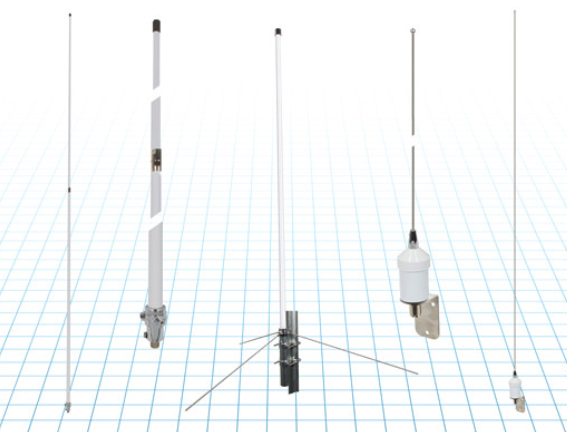
Fairview Microwave has launched commercial marine-grade ship/boat RF antennas that provide accurate positioning with L1 band and multiband capabilities, and offer a 28 dBi gain for reliable positioning.

Fairview’s antennas offer full-spectrum connectivity and operate within the universal marine frequency range of 156 MHz to 163 MHz and CB-27 MHz, 10m-HAM, ensuring unbroken connections at sea. The antennas are also weatherproof, rated IP67 for water ingress.

The antennas are offered with three types of mounts, making it easier to integrate into any vessel.

All antennas are crafted from robust stainless steel or fiberglass for durability and reliable performance. Various antenna lengths are available for users to select based on their signal performance needs.

The commercial marine-grade ship/boat RF antennas are available on the Fairview Microwave website.