Publicerad den Lämna en kommentar

Innoviz Technologies develop lidar platform for Level 3 BMW automated vehicles

Image: Innoviz Technologies

Image: Innoviz Technologies

Innoviz Technologies, a lidar technology company, and the BMW Group, a manufacturer of vehicles and motorcycles, have collaborated on a B-sample development phase for a new-generation of lidar. Under the development agreement, Innoviz will develop the B-samples based on its second-generation InnovizTwo lidar sensor to enable Level 3 automated driving capabilities.

“Lidar is one of the critical technologies underpinning Level 3 or even higher automated functions,” Nicolai Martin, BMW Group’s SVP of driving experience, said. “Optimizing lidar technologies and costs are the major challenges in order to bring Level 3 highly automated driving into the mainstream.”

The companies already have been working together for a few years on an existing program that includes the first deployment of lidar-enabled highly automated technology on the BMW 7 Series, which will launch later this year.

In addition to the lidar solution for the BMW 7 Series, the BMW Group and Innoviz have started the first phase of development for a lidar-based minimal risk maneuver system (MRM). The MRM acts as a secondary safety driving decision platform that will leverage the InnovizTwo lidar sensor to manage real-time driving decisions.

Publicerad den Lämna en kommentar

Advancing geomatics tradecraft and education in the public interest

Image: stock_colors/E+/Getty Images

Image: stock_colors/E+/Getty Images

Anyone keeping up with my columns may know that I have been highlighting the geodesy crisis and programs that advance the science of geodesy (July 2020, November 2022, December 2022, and March 2023). On June 13-15, I had the privilege of participating in a working group event convened by the Geomatics Emerging Scientist Consortium for Education, Research and Capabilities Enhancement (GEO-ESCON). The GEO-ESCON, established in the summer of 2022, is a multi-university consortium serving the need of the Office of Geomatics of the National Geospatial-Intelligence Agency (NGA) for personnel with advanced geomatics expertise, a sustainable pipeline of critical geomatics skillsets, and capabilities enhancement in geomatics and other applied sciences. The 15-member consortium is led by The Ohio State University (OSU), which serves as GEO-ESCON’s managing higher education partner.

GEO-ESCON is part of OSU’s Battelle Center for Science, Engineering and Public Policy in the John Glenn College of Public Affairs. As stated in an OSU press release, OSU was selected for its role with GEO-ESCON because of its longstanding commitment to geodetic education — its collegiate geodetic program is the oldest in the United States and offers undergraduate and graduate degrees in both geodetic engineering and geodetic science.

OSU is home to more than 80 researchers across six colleges who focus on core research and development aspects of geospatial science and technology, including geodesy, remote sensing, photogrammetry, GIS, positioning, navigation, and timing (PNT), computer vision, mobility, smart cities, data analytics, autonomous systems (UAS, UUS and UGV), medical imaging, and precision agriculture.

The GEO-ESCON consortium is designed to create a geographically distributed, multi-disciplinary network of universities to educate the federal geomatics workforce at advanced levels and provide opportunities for applied research and technology development. Higher education institutions are invited to participate in GEO-ESCON based on their capabilities in geomatics. As of July 18, the consortium has 15 members and two additional universities are in the process of becoming members. Click here for all GEO-ESCON member institutions.

GEO-ESCON convened the June Geomatics Challenge Working Group to discuss pressing geomatics challenges and discuss potential solutions. The event facilitated dialogue between representatives from NGA’s Office of Geomatics and academic attendees on geomatics challenges of national priority that could result in actionable proposals to address the challenges. The working group enables representatives of GEO-ESCON member institutions to gain a deeper understanding of NGA’s geomatics priorities, build relationships with NGA leaders, collaborate with colleagues at other institutions, and provide recommendations to GEO-ESCON and the NGA. There were 47 academic participants representing 14 universities.

NGA aims to encourage institutions with varied expertise to propose solutions that achieve greater outcomes through collaborative work. The agency provided six broad categories of geomatics challenges for discussion. See the image below for the categories of interest.

Proposals submitted in response to the June Geomatics Challenges Request for Proposals (RFP) will be eligible for funding consideration and selected activities are expected to be awarded before the fall semester.

The word “tradecraft” in the categories of interest was intriguing. In general, tradecraft refers to the skills, techniques, and practices used by professionals in various fields to carry out their work effectively and discreetly. During World War II, however, the term became associated with spy work and now is mostly used to refer to the techniques and procedures of espionage. NGA is concerned with the dramatic drop in the number of individuals pursuing careers in geodesy — that is, the geodesy crisis in the United States.

Event attendees were asked to prioritize the topic(s) that most interested them, so that they could join a small group on the topic to identify issues, and discuss approaches, solutions, and potential actions for the challenge. Several universities had multiple representatives, so they selected different topics aligned with their individual interest.

The meeting had professional workshop facilitators, technical advisors, NGA subject matter experts (SME), and student recorders. Facilitators encouraged the full participation of all attendees to elicit a range of viewpoints and generate previously unconsidered solutions that could bridge differences in approach — resulting in solutions that were supported by many.

The small groups aligned with a specific challenge utilized the expertise of technical advisors — experts in geomatics or related fields with considerable industry, government, and/or research experience — who supported the development and maturation of proposed Geomatics Challenge solutions. The role of technical advisors was to work with the other leaders in their small group to encourage the full participation of all attendees and mentor the groups toward the generation of novel solutions. I was a technical advisor for the “unified height” topic.

NGA’s SME participated in the working group activities and provided additional context for the individual topics, and other unclassified details related to the Geomatics Challenges.

To capture the discussions at the group meetings, student recorders took detailed notes during the small group discussions. The recorders were graduate students — primarily in geodesy or other STEM fields — and they did an excellent job of capturing the discussion, action items, and potential proposals.

As previously stated, individuals self-selected the topic that interested them but over the course of the three-day meeting individuals were asked to participate in other Geomatics Challenge small groups to provide constructive critiques to produce the best research projects. This was an excellent concept that, in my opinion, helped to improve draft proposals and identify new collaborative projects.

As an example, the need for a unified height system that defines, assesses and correlates all height measurement processes became very evident when individuals participating in the “remote sensing and geophysics” topic engaged with the “unified height” topic members. This joint-topic group meeting helped form new partnerships and formulate new proposals.

The GEO-ESCON and the participating institutions have an ambitious schedule of submitting and awarding the grant proposals before the end of the government’s fiscal year. That said, the participants appeared to be up to the challenge and prepared to make it happen. For obvious reasons, I cannot describe any of the projects discussed, but I will highlight them when they become available for public distribution.

For now, I would like to state that GEO-ESCON is a great program, and it supports the advancement of the science of geodesy and geomatics. I believe that integrated and collaborative organizations are necessary for the successful development of geospatial products and services, and GEO-ESCON is the epitome of this concept. If you believe your institution would benefit from joining this consortium, I encourage you to visit their website to learn more or reach out directly to GEO-ESCON’s team (geoescon@osu.edu). Click here to subscribe and stay up to date on GEO-ESCON news.

In conclusion, as in my previous column, I would like to remind everyone that geodesy is the foundation for all geospatial products and services.

Publicerad den Lämna en kommentar

NextNav tests 3D PNT service leveraging cellular infrastructure

NextNav logo

NextNav has successfully tested its positioning and timing solution that combines the company’s assured position, navigation and timing (PNT) TerraPoiNT system with existing LTE and 5G network signals. The test, which took place in San Jose, California, demonstrated how TerraPoiNT signals can be integrated with existing cellular signals to deliver accurate 3D positioning and timing information that is not reliant on GPS and GNSS signals.

Using dedicated terrestrial transmitters and LTE/5G signals, NextNav’s system delivers accurate and reliable 3D positioning and timing information and can augment or complement GPS in places where GPS signals may not be available. Integrating TerraPoiNT with LTE and 5G signals provides a rapid and cost-effective approach to scaling resilient PNT solutions in GPS-denied environments.

“Whether its utilities, banks, data centers, transportation, or emergency services, critical infrastructure today is reliant on GPS for position, navigation and timing services, making it highly vulnerable to GPS as a single point of failure” said Ganesh Pattabiraman, co-founder and CEO of NextNav. “With this integration, we have demonstrated a highly scalable and lower cost alternative — a 3D PNT solution which overcomes the vulnerabilities of GPS with a complementary ground-based resilient PNT layer that extends PNT capabilities in urban and indoor environments.”

Publicerad den Lämna en kommentar

L3Harris completes AUV launch and recovery from underway submarine

Image: L3Harris

Image: L3Harris

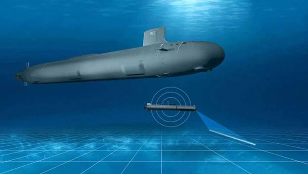
L3Harris has completed a fully autonomous launch and recovery of an autonomous underwater vehicle (AUV) from an underway submarine, referred to as Torpedo Tube Launch and Recovery (TTL&R). The launch used Iver4 AUV technology from L3Harris.

The L3Harris team worked closely with the U.S. Navy to demonstrate AUV launch and recovery through a test program aboard submarines and Navy support vessels.

The recovery of AUVs into an underway submarine allows the host platform to remain covert while the AUV performs surveys and missions in areas inaccessible to the host platform. The AUVs return with data that can be used for tactical and navigational planning — delivering manned and unmanned teaming to a fleet.

According to L3Harris, the company welcomes the continued opportunity to support the Navy in the development of manned and unmanned operational concepts. This capability will increase operational effectiveness and allow SSN-class submarines to serve as an AUV mothership.

Publicerad den Lämna en kommentar

Thales partners with ESA on Galileo cybersecurity and enhancements

From left to right: Sylvain Loddo, director of the Galileo ground segment program at ESA, Ennio Guarino, head of the EGNOS and Galileo programs at ESA, Lionel Salmon, director of cybersecurity for information systems at Thales, and Alexandra Porez, director of cybersecurity for satellite systems at Thales. (Image: Thales)

From left to right: Sylvain Loddo, director of the Galileo ground segment program at ESA, Ennio Guarino, head of the EGNOS and Galileo programs at ESA, Lionel Salmon, director of cybersecurity for information systems at Thales, and Alexandra Porez, director of cybersecurity for satellite systems at Thales. (Image: Thales)

Thales and the European Space Agency (ESA) will be working together on the cybersecurity aspects of the Galileo Second Generation (G2G) program.

Under the partnership, Thales’ scalable and flexible architecture, and security equipment will enable the G2G program to strengthen its ability to detect and respond to new cyberthreats. The end-to-end solution Thales proposed will contribute to the development of greater security and resilience of satellites.

In addition, Thales Alenia Space has partnered with the ESA to design and build the G2G ground mission segment, as well as support system engineering and technical assistance activities. The company also will provide six of the 12 satellites of the constellation.

The second-generation ground mission segment is designed to generate and connect the navigation services to the Galileo satellites and to keep the satellites synchronized with a common time reference. The first version will arrive in time for the launch of the first second-generation satellites and for the validation of the system’s in-orbit capabilities. The second version will be responsible for the missions of both the first- and second-generation Galileo satellites.

The new ground mission system, which includes several major technological innovations, will provide more than four billion users worldwide with improved performance in terms of positioning, navigation and synchronization.

Publicerad den Lämna en kommentar

ComNav device aids in skyscraper completion

Image: ComNav Technology

Image: ComNav Technology

Four T300’s from ComNav Technology have been used as active control GNSS points on the top of Sweden’s tallest building, Karlatornet, during its construction to deliver 3D coordinates to total stations and one was used as a base station. The building is set to be complete this month.

The T300 is a receiver with radio frequency, a baseband chip built in, and a unique quantum-real-time kinematic (RTK) algorithm. It supports full constellation systems including BDS-2, BDS-3, GPS, GLONASS, Galileo, QZSS and NavIC.

The receiver is designed for demanding surveying tasks, features tilt compensation, 4G/Wi-Fi connection, 8-GB internal memory and an easy survey workflow with Android-based Survey Master Software. It is designed to make collecting accurate data easy and fast, whether done by a beginner or experienced professional surveyor, the company said.

Publicerad den Lämna en kommentar

China threatens U.S. GNSS dominance

Photo:

Image: Nikada/E+/Getty Images

A report by CNBC — based on a paper published by Harvard’s’ Belfer Center for Science and International Affairs and written by Sarah Sewall — noted a growing concern that China’s BeiDou is technologically superior to GPS and serves much of the population better.

Experts in the CNBC report explained that BeiDou supports China’s military ambitions, has spurred economic growth in the country, and has increased its diplomatic leverage.

The first BeiDou satellite was launched in 2000 and served only mainland China. The system now consists of 45 operational satellites with 30 of them being the latest generation BDS-3 satellites.

Image: Bedou.gov

Image: Bedou.gov

In 2020, China launched the last BeiDou satellite, completing the constellation. Since then, the influence of BeiDou has grown, with an estimated 1.1 billion people now using the system.

One feature in the latest BeiDou satellites is two-way messaging that is mainly available in China and requires special chips that are not widely available in the consumer market. It enables users to send short messages in areas without ground network cell coverage and can be used for search and rescue operations.

Surveillance fears

The CNBC report noted the fear that, with its enhancements, the BeiDou system could be used as a surveillance device — as the two-way messaging feature reveals a user’s locations as well as other types of data.

Additionally, with the growing number of apps for cellphones and an increase in autonomous vehicles that use the BeiDou system, more and more user data is being transmitted.

The bottom line

Satellites in the United States’ GPS constellation do not yet have those kinds of features.

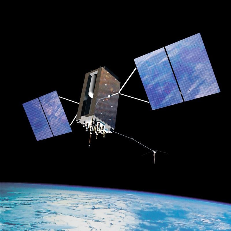
There are 31 operational GPS satellites, 6 of which are GPS III satellites.

Image: GPS.gov

Image: GPS.gov

GPS satellite modernization 

In 2008 Lockheed Martin beat out Boeing — the manufacturer of older GPS satellites — to build the GPS III satellites, the last of which was delivered in February. GPS III satellites deliver enhanced performance through a variety of improvements, including increased signal protection with improved accuracy.

GPS III SV07, SV08, SV09 and SV10 (SV stands for “space vehicle”) are awaiting launch at Lockheed Martin’s GPS III processing facility in Waterton, Colorado.

Lockheed Martin is now working on 22 GPS IIIF satellites — contracted in 2018 — that will feature more advanced capabilities. These satellites are expected to launch in 2026.

The U.S. Space Force exercised its second contract option valued at approximately $737 million for the procurement of three additional GPS IIIF space vehicles from Lockheed Martin on Oct. 22, 2021. This contract option is for GPS IIIF satellites 15, 16 and 17 (SV15-17).

The entire fleet of GPS satellites is expected to be modernized in 2032 or 2033. However, for now, President Biden’s National Space-Based Positioning Navigation, and Timing (PNT) Advisory Board recognizes the need for a resilient national PNT architecture and acknowledges that BeiDou is technologically superior to GPS.

Publicerad den Lämna en kommentar

Galileo gains new ground segment facility

Image: ESA

Image: ESA

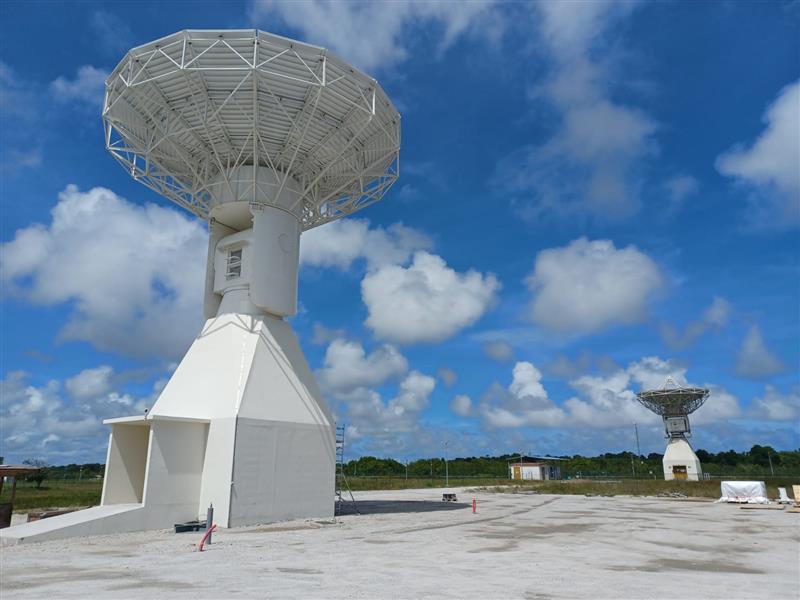
Galileo’s ground segment has gained a new asset, the Telemetry, Tracking and Control (TT&C) facility — a 13.5-m parabola dish mounted on top of a 10-m high building structure of made of steel and concrete. It is based within Europe’s launch site in Kourou, French Guiana, beside TTCF-2.

The TT&C antennas are uncrewed and operate on a fully automated basis from the two Galileo control centers located in Oberpfaffenhofen, Germany, and Fucino, Italy. The TT&C antennas are crucial to regular communication with the Galileo satellites.

This latest antenna will play an important role during the upcoming modernization activities of the earlier TT&C antennas in the station network, which have been in service for several years. TTCF-7 will take over their tasks during the maintenance activities when they need to be taken offline.

Publicerad den Lämna en kommentar

The sinking city: Maps show Venice may be underwater soon

Venice arose after the fall of the Roman Empire. The city holds 450 palaces, more than 400 bridges and is home to the notable St. Mark’s Basilica. It is also known for its many canals, which are full of gondolas the way the streets of other cities are full of taxis or rickshaws. (Image: Freeartist/iStock/Getty Images Plus/Getty Images)

Venice arose after the fall of the Roman Empire. The city holds 450 palaces, more than 400 bridges and is home to the notable St. Mark’s Basilica. It is also known for its many canals, which are full of gondolas the way the streets of other cities are full of taxis or rickshaws. (Image: Freeartist/iStock/Getty Images Plus/Getty Images)

It is hard to believe that Italy’s “floating city” could be underwater soon.

The average rate of relative sea-level rise is 2.5 mm/year, per the European Geosciences Union’s journal Natural Hazards and Earth System Sciences. This photo of Venice from the European Space Agency (ESA) was taken in 2008 by Ikonos-2, a commercial satellite (Image: ESA)

The average rate of relative sea-level rise is 2.5 mm/year, per the European Geosciences Union’s journal Natural Hazards and Earth System Sciences. This photo of Venice from the European Space Agency (ESA) was taken in 2008 by Ikonos-2, a commercial satellite (Image: ESA)

Predictions for the future of the city vary, but most scientists agree that the sea level is rising due to climate change. Natural Hazards and Earth System Sciences, an interdisciplinarity  journal of the European Geosciences Union, published a report in 2021 suggesting the average sea level could be between 17 cm and 120 cm higher in Venice by 2100.

Venice was built in the middle of a shallow lagoon in the Adriatic Sea. Therefore, it has always been at risk of flooding or “acqua alta,” meaning high water. There is evidence of severe flooding dating back to around the 8th century.

The Venetian lagoon is more than 500 km2 in total, but has an average depth of only 1 m, according to Royal Museums-Greenwich. High tides and severe storms have a devastating impact on the wetland environment on which Venice is built.

Compared to the image of Venice in 2008, this U.S. Geological Survey (USGS) satellite image of Venice from May 2023 shows the rise in sea level within the past 15 years. (Image: USGS)

Compared to the image of Venice in 2008, this U.S. Geological Survey (USGS) satellite image of Venice from May 2023 shows the rise in sea level within the past 15 years. (Image: USGS)

In November 2019, Venice experienced the second-worst flooding event in almost 100 years. The tide reached 187 cm (6.1 ft) above sea level, covering 80% of the city in water, reported the BBC.

City records show there have been 324 intense high-water events since 1872 and more than half of those have been in the past 30 years. Among the many and vast consequences of human-caused climate change may be the end of one of the world’s most beautiful cities.

Only time will tell the fate of Venice.

Publicerad den Lämna en kommentar

1Spatial launches configurable GIS mobile app for surveying

Image: 1Spatial

Image: 1Spatial

1Spatial — a global provider of geospatial software and solutions for improved data governance — has launched the 1Capture, a customizable mobile application for data capture.

1Capture is a mobile GIS editing application that is multi-use and configurable. It provides accurate and reliable GIS data collection and editing in the field for a multitude of asset, job, and survey types.

Customizable rules and actions work to improve data quality at the point of capture. This ensures good quality data is captured at source, minimizing re-surveys. The built-in rules engine automatically validates and corrects the GIS and non-GIS data collected, whether working online or offline.

1Capture connects with a variety of GIS environments including Esri ArcGIS and open-source technologies such as PostGIS and Geoserver.