Publicerad den Lämna en kommentar

What Gen X means for the future of surveying

Photo: iStock.com/Georgijevic

Photo: iStock.com/Georgijevic

The surveying profession has come to a crossroads, and is divided amongst itself to boot. A gap exists within the profession, and yes it is a generation gap, based on how technology has evolved and how the different generations experience it differently. In this column I explore the histories both of the generations and the technology to reach conclusions on how best to move forward — together.

Surveyors now have more tools than ever before available to them to perform their tasks. But surveyors of different ages regard these tools differently. Not to put too fine a point on it, the younger porfessionals among us feel their creativity and desire to further the profession is being stifled by the group who is supposed to be leading and mentoring them.

Why is this crucial to consider? Because these are the future users, purchasers and adopters of geospatial equipment and software, and the future setters of industry standards. All involved, from manufacturers to distributors to surveyors themselves, would do well to think deeply upon this.

As we enter the final stretch of the 21st century’s second decade, many things have changed since the Y2K scare and the proliferation of the Interweb. From deregulation of the surveying profession to changing coordinate systems and datums, the surveying profession faces many challenges in 2019. One of the biggest challenges we face has nothing — yet everything — to do with technology.

Talented people are necessary to grow our profession. We are falling well short of having enough to keep up with demand. Sounds like a simple problem; just hire more surveyors and technicians. This sounds easy, but several roadblocks confront us.

A select few still invest in their surveying future by going to college to get a degree and eventually become a licensed surveyor. These individuals find, however, that the road to success has lots of potholes along the way, just as their elder predecessors did.

Recently, I participated in a group discussion with the National Society of Professional Surveyors (NSPS) Young Surveyors Network to discuss surveying, technology and the young surveyor’s role in promoting future career opportunities. This discussion was part of Network’s series of meetings and seminars held in parallel with the main NSPS Spring Business Meetings.

While I think of myself as still “young-ish” (in my early 50s), being the oldest participant in that group was intimidating, to say the least. These young technicians and surveyors are driven and focused, yet they seek the same feedback and mentoring that I desired when I was their age.

In the weeks after that meeting, some of the items discussed continued to resonate with me and forced me to reflect on my own experiences and career path. To be fair to them and truly understand their views on today’s surveying profession, I needed to look beyond the profession, policies and procedures to which I hold fast in my ethical approach to the craft. These younger generations have been exposed to a completely different world than the one I remember fondly, and the world they grew up in has subjected them to challenges to which I cannot relate. To help explain the conundrum of trying to find a way to relate, we need to take a step back and look at not just generational values but how the many industrial revolutions have affected us as well.

TALKING ‘BOUT MY GENERATION

The first part of my research to help me find a way to step into the shoes of these young surveyors was to look at past generations and how they relate to each other. Going back to the turn of the 19th century, we get the following breakdown:

Traditionalists or Silent Generation: Born before 1945

This timeframe contains sub-groups including the “lost generation of 1914,” the “interbellum” and the “greatest generation.” Alaska and Hawaii were not included in the United States during this period. Most of the country west of the Colonial states was subject to the government Public Land Survey System started in the early 1800s. The Great Depression took its toll on much of the population, and previously rapid expansion slowed to a standstill.

Baby Boomers: Born 1946 – 1964

World War II changed the world. Soldiers returning from military duty to start or resume families accelerated population growth and a departure from traditional social attitudes. Two-income families emerged, and prosperity ruled for many years. Surveyors, teaming with civil engineers, helped fuel an unprecedented explosion of real estate expansion through planned developments across the country.

Generation X: Born 1965 – 1976

The children of the fast and free-living Baby Boomers grew up to become the Gen Xers. They were the first “latchkey” kids, more likely to be raised by divorced or remarried parents. As young adults, in their effort to enhance their lifestyle more than their parents, they did many things to the extreme with no consideration of cost. This led to massive real estate developments, “McMansions” and increased debt. Surveying continued to flourish but most growth was enjoyed by engineering firms who absorbed surveyors to expand their services.

Millennials or Gen Y: Born 1977 – 1995

This group is often labeled as the “Peter Pan” generation for its predisposition to put off typical adulthood norms like marriage, having children and buying real estate. They have a propensity to be more mobile and nomadic, as they take advantage of technology and rapidly changing environmental factors. With this generation we find the slowdown in career choices towards surveying, even though technology and spatial data acquisition have exploded with potential.

Gen Z, iGen, or Centennials: Born 1996 – Current

This generation was born into technology, and it affects everything they do. From infancy they were experienced soothing music, dancing screens, interactive toys, and dolls teaching them new skills. This generation doesn’t know of a world without computers, cellphones, GPS-based maps or high-speed internet. Surveying has also benefitted from the technology explosion but it hasn’t captured the imagination of this generation sufficiently to develop future practitioners.

YOU SAY YOU WANT A REVOLUTION. WELL, YOU KNOW…

The generational differences only tell part of the story. Each one faced its own challenges when it came to technology (or lack thereof), societal standards, and other facets of their respective eras. A succession of several Industrial Revolutions brought new tools for completing a wide array of tasks and procedures. Here is a summary of each of them in chronological order:

First Industrial Revolution (1784)

Mechanical production via water and steam power led the way during the late 1700s and began a trend of radical changes in the ability to create larger items. The Gunter chain and surveyor’s compass, both invented in the 1600s, were the mainstay of measuring tools during this time period.

Second Industrial Revolution (1870)

Mass production and increases in labor opportunities coupled with the adaptation of electricity in many areas enabled people to flourish like no other time to date. The optical theodolite with horizontal angle measurement was introduced and then mass produced in the late 1800s to help surveyors make more progress westward.

Third Industrial Revolution (1969)

A significant leap forward in technology occurred with the invention of the microprocessor in the late 1950s, followed quickly by rapid development of electronic machines designed to follow manual instructions. Programmable controllers and devices were born from the fast-paced development of sophisticated miniaturized circuitry. These developments were used to create measurement devices for sending infrared and visible light waves across long distances. In the late 1970s, technological advancements led to the development of electronic theodolites or total stations. These instruments were the first to be able to electronically determine the horizontal and vertical angles normally read manually by the operator, and to combine this data with electronic distance measurement. Further development created methods of storing this data electronically for input into computer calculation and drafting programs.

Fourth Industrial Revolution (Current)

Industry experts differ as to when the Fourth Revolution began, but all agree we have turned the corner and are now fully entrenched into a new realm. Further miniaturization of computer chips, advanced sensors and storage, and robotic mechanisms have introduced a new reality for everyone, including the surveyor. Today’s practitioner has many sophisticated tools available for work, including GNSS receivers, laser or LiDAR scanners, UAVs with a multitude of sensors, hydrographic vehicles with single and multi-beam fathometers, and many more instruments currently under development.

Surveyors now have more tools than ever available to perform their tasks. Now we must cross-reference these revolutions with the practitioners from the various generations to help us understand upon which road the profession is headed.

TECHNOLOGY MEETS GENERATIONAL DIFFERENCES; WHAT COULD GO WRONG?

One thing that stood out in my aforementioned discussion with the young surveyors’ group was how much they were embracing technology not just in their every day lives and communication, but how they understood the enhanced abilities of the latest tech and instruments for surveying. They see the value in large data, point clouds and BIM (building information modeling) needed for industry use.

The general consensus from this group was that my generation (Gen X) and earlier (Baby Boomers) are easily dismissive of their enthusiasm for incorporating these new technologies into our workflow simply as ways to shortcut old methods done by more labor-intensive means. While I initially tried, myself, to dismiss this suggestion, further research has only proven their point: their creativity and desire to further the profession is indeed being stifled by the group that should be leading and mentoring them.

Cross-correlating the generations with their various personalities and quirks with the amalgamations of industrial revolutions turns up some interesting results. Gen Xers and earlier surveyors were strictly taught by their managers and mentors that both historical data and original monuments are sacred and not to be denied. This information was derived from the most basic of survey instruments and measuring equipment, with accuracy that is not acceptable by today’s standards.

But the tradition remained: if it was good enough for our forefathers to establish the early frontier, then more accurate measuring devices are simply overkill. New sophisticated robotic total stations, GNSS receivers and robust data collectors available as a result of the Third Industrial Revolution are shiny objects that stand in the way of “good surveying,” in the opinion of the elder surveyors.

Millennial surveyors, meanwhile, look at the world with a different vision and much different solutions. Most of them were not exposed to televisions with just three channels, telephones mounted on walls, or kitchens without microwave ovens, to just to name a few “antiquities.” Their families have always owned a computer and the library is a place where you go to study. Research isn’t looking in an encyclopedia; you Google. They embracw cellphones with a multitude of apps and functions, including location services within a few feet, practically as extensions of themselves.

The equipment produced for surveyors today is well within their wheelhouse as it maps a multitude of points and features in a blink of an eye. Accuracy and detail are no longer an issue — but adapting that data to legacy deeds and maps is where us old timers can help bridge the gap.

Another problem that has proven to be a yawning void between the generations is the remnants of the economic slowdown of 2007-2012. Many Baby Boomer and Gen X surveyors learned to do more with less. Times were tough and we couldn’t afford to upgrade to the latest versions of total stations, GNSS, software, or invest in new technologies like laser scanning. There was also an exodus of technicians simply because there was no work in surveying for the time period, and they found employment in other professions. That left a void in who was doing the work (now being completed by upper level surveyors with older skill sets), and having no younger personnel to train and groom for future career growth.

There were many technological advancements during that time frame but overall the industry suffered because of the economic downturn. The Millennials, most of whom were too young to be employed during this period, now are faced with working for an older profession that couldn’t afford to stay current with technology and who have trouble relating to the motivations of the younger generation.

CAN’T WE ALL JUST GET ALONG?

I believe the surveying profession is at a crossroads, one based upon the gap caused by the generation / technology combination described above. Steps must be taken to rectify this. Here are a few of the pathways to closing the gap and becoming a solid profession for the future:

  1. Embrace the mentor/mentee relationship, but be open to reversing the roles. The younger generations have a handle on the latest technology, so us old timers need to be more willing to close our mouths and open our ears and minds.
  2. Create more opportunities for younger surveyors to participate in organizations so they can also be influencers. Keep in mind that they don’t typically like to “belong” to an organization, so adapt our professional groups and keep their interests in mind.
  3. Change the way we communicate. Many Baby Boomers / Gen X members are critical of the younger generations and social media, yet this trend shows no sign, at all, of stopping. Smartphones are here to stay, so let’s learn to adapt, to remain in step with the youngsters.
  4. Be willing to invest in new and emerging technology. Who know where the next radical survey technique will come from if you don’t have an open mind and checkbook? Invest not only in equipment but your young staff’s future.
  5. Encourage younger staff to get involved in something. Anything. Social interaction can lead to better communication skills and expose them to more business situations. Don’t push them in over their head,s but get them to be “uncomfortable” occasionally. They will thank you for it.

Many professions and occupations will suffer in the next 3–5 years because of attrition through retirement, incapacitation and death. These workforces will lose 20–40% of their workers. Those left will have to pick up the slack and then some. We need to either

A) hire a lot more surveyors, or

B) figure out how to make it work with less bodies.

The conversation that took place in that meeting room with the young surveyors has made a deep impression on me and has changed my focus on the future of surveying. How does this apply to an article in a geospatial publication? Simple: these are the future users, purchasers and adopters of geospatial equipment and software, and the setters of industry standards.

The younger generation understands how to use today’s technology, and the surveying profession overall needs to embrace that fact. The technology won’t mean a thing if we don’t have the bright minds to use it to its full potential.

So I ask you again to embrace, encourage and listen to the young surveyors; they will thank you for it.

Publicerad den Lämna en kommentar

L3Harris Technologies merger completed

L3Harris Technologies announced the successful completion of the all-stock merger between Harris Corporation and L3 Technologies on June 29. Headquartered in Melbourne, Florida, L3Harris becomes the sixth largest defense company in the U.S., and a top 10 defense company worldwide, with approximately $17 billion in revenue and 50,000 employees, including 20,000 engineers and scientists.

[Photo: The Harris-supplied navigation payload before integration into the second GPS III SV. (Photo: Harris)]

Both companies have long been dominant presences in the U.S. GPS industry: Harris as a provider of the GPS satellite navigation payloads and geospatial intelligence software products, and L3 as a provider of military GPS user equipment and guided munitions. Both companies supply a wide range of other geospatially-related products as well.

L3Harris has organized its operating businesses into four segments to best meet customers’ mission requirements and leverage the combined company’s broad technical capabilities:

Integrated Mission Systems — headquartered in Palm Bay, Florida, with approximately $4.9 billion in revenue. Includes intelligence, surveillance and reconnaissance; advanced electro optical and infrared solutions; and maritime power and navigation
Space and Airborne Systems — headquartered in Palm Bay, Florida, with approximately $4.0 billion in revenue. Includes space payloads, sensors and full-mission solutions; classified intelligence and cyber defense; avionics; and electronic warfare
Communication Systems — headquartered in Rochester, New York, with approximately $3.8 billion in revenue. Includes tactical communications; broadband communications; night vision; and public safety
Aviation Systems — headquartered in Arlington, Texas, with approximately $3.8 billion in revenue. Includes defense aviation products; security, detection and other commercial aviation products; air traffic management; and commercial and military pilot training

Shares of Harris common stock, which traded on the NYSE under the ticker symbol “HRS,” began trading on July 2 under the ticker symbol “LHX.” L3 Technologies shares ceased trading upon market close on June 28 and have converted into 1.3 L3Harris shares for each L3 share.

The merger comes at approximately the same time that two other leading GPS companies, Raytheon and United Technologies, itself a merger including the former Rockwell Collins, now Collins Aerospace, also merged.

Publicerad den Lämna en kommentar

Congressman DeFazio: ‘GPS backup vital for national security’

RNT Foundation Directors and Congressmen. From left: RADM Jeff Hathaway, USCG (ret); Rep. John Garamendi (D-CA); Rep. Peter DeFazio (D-OR); Dana A. Goward, SES, CAPT, USCG (ret); and CAPT Pauline Cook, USCG (ret). (Photo: Resilient PNT Foundation)

RNT Foundation Directors and Congressmen. From left: RADM Jeff Hathaway, USCG (ret); Rep. John Garamendi (D-CA); Rep. Peter DeFazio (D-OR); Dana A. Goward, SES, CAPT, USCG (ret); and CAPT Pauline Cook, USCG (ret). (Photo: Resilient PNT Foundation)

“It’s absolutely vital for national security that we get a terrestrial based, hard backup system [for GPS]” according to Congressman Peter DeFazio (D-OR), Chairman of the powerful House Transportation and Infrastructure Committee.

His remarks came at an event organized by the RNT Foundation to recognize DeFazio and Congressman John Garamendi (D-CA) for their support of the National Timing Resilience and Security Act of 2018. Representative Garamendi is chairman of the House Armed Services Readiness subcommittee.

Garamendi first introduced legislation in 2016 to address the nation’s need for a GPS backup system. After going through several iterations, it was signed into law in December. The Act requires the Department of Transportation to establish a terrestrial timing system by 2020. Also, that the new system be expandable to one that can be used for location and navigation.

Congress funded a GPS Backup Technology Demonstration through a Department of Defense appropriation in early 2018. The demonstration was intended to be a joint project of the Departments of Defense, Homeland Security, and Transportation. A delay in transferring funds from Defense to the other two departments put the demonstration almost a year behind schedule. Now that the project is underway, Transportation Department representatives have said they want to transition directly from the demonstration to deciding upon and implementing the mandated timing system.

At the event, DeFazio remarked that as a boater and hiker he is an avid user of GPS. He mentioned that it is an “ incredible utility, but I also know of its vulnerability. It’s critical to national security and the meaningful movement of everything in the United States of America from airplanes to surface transportation and others … It’s absolutely vital for national security that we get a terrestrial based, hard backup system.” He also noted that Congressman Garamendi has been the driving force for this issue in the House of Representatives.

Speaking about his current role on the Armed Services committee, Garamendi said “The reality is that the military is not prepared for the loss of the GPS signal, and they are just now becoming aware after seven years of beating them over the head saying ‘guys, what are you going to do when you don’t have GPS?’” Garamendi noted that the military would be a big users of the domestic backup system.

He also regretted that after “… years of people saying ‘single point of failure’ for the American economy and system is the loss of GPS” the nation is not farther along to having a backup system.

The RNT Foundation presented the congressmen with plaques showing images of a GPS satellite and a terrestrial transmission tower, and 0ne of America’s “first GPS devices” — a 102-year-old copy of The American Practical Navigator by Nathaniel Bowditch.

Publicerad den Lämna en kommentar

2019 GPS Public Interface Control meeting set for Sept. 25

CGSIC logo

On Sept. 25, the GPS Directorate will host the 2019 Public Interface Control Working Group and Open Forum to update the public on GPS public document revisions.

The meeting will collect issues and comments for analysis and possible integration into future GPS public document revisions.

The 2019 Public Interface Control Working Group and Open Forum are open to the general public. It can be attended in person or by dial-in connection.

Documents Affected

  • IS-GPS-200: Navigation User Interfaces
  • IS-GPS-705: User Segment L5 Interfaces
  • IS-GPS-800: User Segment L1C Interface
  • ICD-GPS-870: NAVSTAR GPS Control Segment to User Support Community Interface

Meeting Address: SAIC, 100 N Sepulveda Blvd., El Segundo, CA 90245, The Great Room

Meeting Dial-in Number: 310-653-2663 Meeting ID: 20190925 Password: 123456.

Documents and proposed changes and the official meeting notice are posted on GPS.gov.

Publicerad den Lämna en kommentar

Dual-frequency Galileo app winners prove power of two

To test the accuracy of the competing satnav smartphone apps, the words ESA and Galileo were traced along ESTEC's football field. The left side uses single frequency GPS and Galileo signals, the centre uses dual frequency signals from the two constellations while the right is with precise corrections. The word "ESA" is 15 meters high, while "Galileo" is 7 meters high. (Photos: ESA)

To test the accuracy of the competing satnav smartphone apps, the words ESA and Galileo were traced along ESTEC’s football field. The left side uses single-frequency GPS and Galileo signals, the center uses dual-frequency signals from the two constellations while the right is with precise corrections. The word “ESA” is 15 meters high, while “Galileo” is 7 meters high. (Photos: ESA)

News from the European Space Agency

Europe’s students and young researchers were challenged to design a smartphone app to take advantage of Galileo’s dual-frequency signals. The winning entries should soon be available to the public.

Run by ESA in collaboration with the European Global Navigation Satellite Systems Agency — GSA — plus the European Commission with the support of Google, a total of five teams made it to the final, which took place at ESA’s ESTEC technical heart in the Netherlands.

Following on from last year’s inaugural competition — which has already resulted in the winning app becoming publicly available — this year’s event challenged teams to make use of the dual-frequency capability of the latest smartphones running Android 8.0, including and computing dual-frequency positioning solutions from satnav signals to compare them with their single frequency equivalents. The competition slogan was “Galileo give mE5,” referring to Galileo’s dual E1 and E5 frequencies.

“Galileo give mE5”

The objective of the competition was to reach meter accuracy or less worldwide in unobscured sky, while allowing the user to select Galileo-only positioning, GPS-only positioning and the combination of both on a simultaneous basis, with the potential to include other satnav constellations in turn.

The winner was selected based on technical checks and a jury’s vote. Separate awards were also given to the most innovative app and the winner of a public vote.

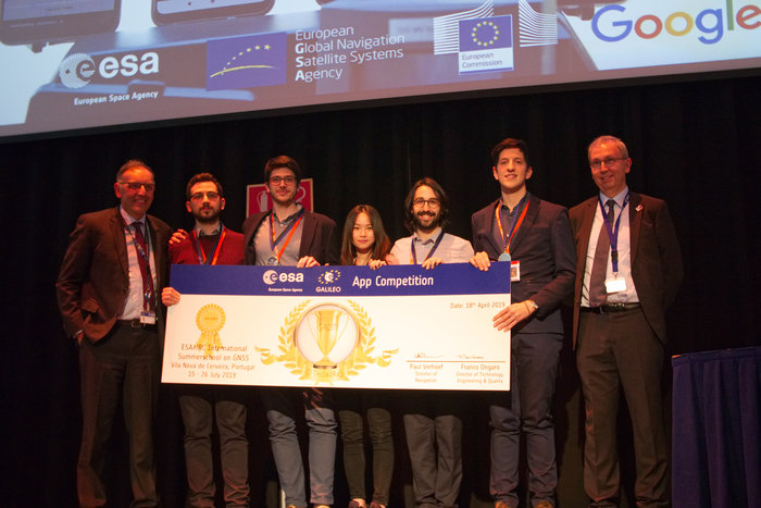
The multinational O ThiSaVRoS team — named after the Greek word for treasure — developed the “GNSS Android-based Dual Frequency Iono-estimating Precise Point Positioning” or GADIP3 app.

The multinational ‘O ThiSaVRoS’ team – named after the Greek word for treasure – developed the ‘GNSS Android-based Dual Frequency Iono-estimating Precise Point Positioning’ or GADIP 3 app, winning the ESA-EC-GSA Galileo smartphone app competition 2019. (Photo: ESA)

The multinational ‘O ThiSaVRoS’ team – named after the Greek word for treasure – developed the ‘GNSS Android-based Dual Frequency Iono-estimating Precise Point Positioning’ or GADIP 3 app, winning the ESA-EC-GSA Galileo smartphone app competition 2019. (Photo: ESA)

Winners

The app allows users to perform reliable positioning fixes in real time — selecting which constellations to employ and a choice of single or dual frequency signals — while advanced users can modify the way the positioning is performed, and log all available data for follow-up analysis.

“Our mission goal is to provide precise positioning to everyone,” explained team coordinator Lotfi Massarweh. The O ThiSaVRoS team performed analysis on more than 120 hours of data from stationary, pedestrian and mobile testing to come up with a pre-processing approach involving rejection of signals from low elevation and under a specific signal-to-noise ratio.

The five-person team hail from China, Greece, Italy and Spain, studying at Portugal’s Instituto Superior Técnico Lisboa, Delft University of Technology in the Netherlands, Germany’s Leibniz Universität Hannover and the Universities of Bath and Nottingham in the UK. They worked remotely to develop and test the app over the previous six months.

NavGate allows geo-tagging in augmented reality

The NavGate smartphone app allows the sharing of geo-tags in augmented reality via the phone's camera, as well as on maps. (Image: ESA)

The NavGate smartphone app allows the sharing of geo-tags in augmented reality via the phone’s camera, as well as on maps. (Image: ESA)

As their app’s name suggests, O ThiSaVRoS hope to achieve precise point positioning in future, made possible by dual-frequency signal availability, to come close to single-metre-scale precision.

Second place went to the ESTEC-based Team GNSS Tonic’s NavGate app — aimed at bringing people together socially to interesting locations. Users can tag sites of interest to be seen by other people, with the resulting geotags viewable for others either on a map or else directly in augmented reality through their phone’s camera. NavGate could potentially be used for everything from sharing dining recommendations to fishing spots, or meeting up with people during an evening out.

The third prize to the Step with GNSS app by the Romania-based Space Walkers Team, designed to gather data on the paths of users walking outdoors. This game based app is backed up by a server application collecting data from the app users and analysing GNSS performance worldwide or regionally.

Single versus dual frequency

The winner of both the public vote and the most innovative app award went to Universitat Autònoma de Barcelona’s Inari Team and their Inari app.

Inari allows users to select various positioning modes or customise their own, selecting which algorithms and which corrections should be employed as well as specifying constellations and signal frequency. The app can also highlight jamming or spoofing that might be influencing the positioning accuracy.

ESA’s technical evaluation team performed tests of the competing apps in the days running up to the final, including tracing out ESA GALILEO as accurately as possible across the establishment’s football field.

The speaker of the jury, Frank van Diggelen from Google, congratulated the teams on their efforts. “Dual frequency on smartphones is a quite new development, and you really are pioneers in this. The manufacturers are still trying to get things right, and you’re helping them do that bit better. Doing anything for the first time is hard but it’s good to be first, so congratulations for that,” he said.

Galileo smartphone app competition final

The receiver chipsets inside smartphones routinely make use of Galileo in combination with several other satnav constellations — the U.S. GPS, Russian Glonass and Chinese BeiDou. These chipsets function in ‘black box’ style, making the resulting positioning fixes accessible to users, but without giving any option to the user to select which constellation to employ — or information on Galileo’s particular contribution to the phone’s overall positioning performance.

However, in newer Android smartphones it has become possible to access the raw signal measurements used to compute position, opening the door to the development of applications where the user can indeed select which constellations to employ.

The very latest models also allow the use of dual satnav frequencies, giving a major boost to positioning precision. The higher chip rate of the additional frequency allows the chipset to compensate for signal propagation errors from the signals’ journey through the ionosphere — the electrically active outer layer of atmosphere — and reduces false ‘multipath’ detections caused by signals reflecting off buildings.

The top three teams have won attendance to the ESA & EC International Summer School on Global Navigation Satellite Systems in Portugal.

Publicerad den Lämna en kommentar

Israel accuses Russia of spoofing in its airspace

Israeli security officials publicly accused Russia of disrupting and spoofing GPS signal reception in Israeli airspace throughout the month of June. The electronic warfare at which Russia is known to be adept was reportedly traced to the Khmeimim Air Base in Syria, where Russia maintains and actively flies a large number of warplanes on behalf of the Syrian government. The base is approximately about 350 kilometers (217 miles) north of Ben Gurion, so if the accusation is true, fairly powerful equipment is behind the attack.

Both Israeli and other-nationality airline pilots have reported interruptions in GPS reception during take-off and landing at Tel Aviv’s Ben Gurion International Airport. The Israeli Airline Pilots Association labeled the interruptions a spoofing attack, causing airplane receivers to report false positions.

The International Federation of Air Line Pilots’ Associations issued a Notice to Airmen: “GPS signal loss affects RNAV arrivals and departures and may create numerous alerts for systems that rely on internal position accuracy. Flight Crews should be aware of the potential risk, avoid distractions, and plan for alternative procedures as necessary.”

Pilots have since for the most part relied on Instrument Landing System, a precision runway approach aid based on two radio beams which together with both vertical and horizontal guidance during an approach to land at Ben Gurion International Airport.

The Israeli Airports Authority stated that the GPS attacks affected only airborne crews and not terrestrial navigation systems, and that they occur only during daytime.

The Russian ambassador to Israel has denied the accusations.

In April, a U.S. research institute, the Center for Advanced Defense Studies, documented more than 10,000 separate incidents of GPS disruption on Russian soil, in northern Scandinavia and in the Middle East between February 2016 and November 2018. It said Russia was “pioneering” the technique to “protect and promote its strategic interests.” GPS World summarized the report here, stating that “The Russian Federation is growing and actively nurturing a comparative advantage in the targeted use and development of GNSS spoofing capabilities to achieve tactical and strategic objectives at home and abroad.”

Tie-in with Iran Tensions. Meanwhile the Helsinki Times reported that researchers at the Finnish Geodetic Institute noticed unusual power variations in the GPS signal on June 20 and 21: “an increase of up to 10dBHz in the carrier-to-noise ratio readings comparing with the usual daily values.” Normally the variations are between -0.5 and 0.5 dBHz.

The same findings were communicated to the research community by Peter Steigenberger, senior scientist at the German Aerospace Center, DLR:

“Based on carrier-to-noise density ratio observations (C/N0) of IGS receivers, we observed global flex power operations on June 20 and 21, 2019. Flex power started subsequently for all healthy Block IIR-M and IIF satellites on June 20 between 15:18 and 17:49 UTC. C/N0 of the P(Y)-code tracking increased by roughly 10 dB for all healthy Block IIR-M and IIF satellites whereas C/N0 of the C/A-code decreased by about 2-3 dB for the healthy IIR-M satellites only. The changes in power levels are similar to flex power mode III discussed in “Steigenberger P, Thölert S, Montenbruck O. (2019) Flex power on GPS Block IIR-M and IIF, GPS Solutions, doi:10.1007/s10291-018-0797-8″. All satellites returned to normal power levels on June 21 between 6:00 and 10:00 UTC.”

On June 20, a US military drone was downed down by Iranian missiles. On June 21 President Trump tweeted that he had called off a dawn attack on Iran that day.

Whether the spoofing affecting Israeli airspace has any connection to building tensions 1,500 kilometers to the east is unknown.

Publicerad den Lämna en kommentar

Tesla Model S and Model 3 vulnerable to GNSS spoofing attacks

Tesla Model 3. (Photo: Tesla)

Tesla Model 3. (Photo: Tesla)

Autopilot Navigation Steers Car off Road, Research from Regulus Cyber Shows

Tesla Model S and Model 3 — electric cars built for speed and safety — are vulnerable to cyberattacks aimed at their navigation systems, according to recent research from Regulus Cyber.

During a test drive using Tesla’s Navigate on Autopilot feature, a staged attack caused the car to suddenly slow down and unexpectedly veer off the main road. Regulus Cyber, the first company to deal with smart-sensor security across a wide range of applications including automotive, mobile, and critical infrastructure, initially discovered the Tesla vulnerability during its ongoing study of the threat that easily accessible spoofing technology poses to GNSS receivers.

The Regulus Cyber researchers found that spoofing attacks on the Tesla GNSS receiver could easily be carried out wirelessly and remotely, exploiting security vulnerabilities in mission-critical telematics, sensor fusion, and navigation capabilities.

Regulus Cyber experts traveled to Europe last week to test-drive the Tesla Model 3 using Navigate on Autopilot. An active guidance feature for its Enhanced Autopilot platform, it’s meant to make following the route to a destination easier, which includes suggesting and making lane changes and taking interchange exits, all with driver supervision.

While it initially required drivers to confirm lane changes using the turn signals before the car moved into an adjacent lane, current versions of Navigate on Autopilot allow drivers to waive the confirmation requirement if they choose, meaning the car can activate the turn signal and start turning on its own. Tesla emphasizes that “in both of these scenarios until truly driverless cars are validated and approved by regulators, drivers are responsible for and must remain ready to take manual control of their car at all times.”

Designed to reveal how the semi-autonomous Model S and Model 3 would react to a spoofing attack, the Regulus Cyber test began with the car driving normally and the autopilot navigation feature activated, maintaining a constant speed and position in the middle of the lane.

Although the car was three miles away from the planned exit when the spoofing attack began, the car reacted as if the exit was just 500 feet away — abruptly slowing down, activating the right turn signal, and making a sharp turn off the main road. The driver immediately took manual control but couldn’t stop the car from leaving the road.

The testing revealed another unexpected finding that significantly amplified the threat—a link between the car’s navigation and air suspension systems. This resulted in the height of the car changing unexpectedly while moving because the suspension system “thought” it was driving through various locations during the test, either on smooth roadways, when the car was lowered for greater aerodynamics, or “off-road” streets, which would activate the car elevating its undercarriage to avoid any obstacles on the road.

Yoav Zangvil, Regulus Cyber CTO and co-founder, explains that GNSS spoofing is a growing threat to ADAS and autonomous vehicles. “Until now, awareness of cybersecurity issues with GNSS and sensors has been limited in the automotive industry. But as dependency on GNSS is on the rise, there’s a real need to bridge the gap between its tremendous inherent benefits and its potential hazards. It’s crucial today for the automotive industry to adopt a proactive approach towards cybersecurity.”

The Regulus Cyber testing is designed to assess the impact of spoofing with low-cost, open source hardware and software, the same kind of technology that is accessible to anyone via e-commerce websites and open source projects on GitHub. Taking control of Tesla’s GPS with off-the-shelf tools took less than one minute.

The researchers were able to remotely affect various aspects of the driving experience, including navigation, mapping, power calculations, and the suspension system. Under attack, the GNSS system displayed incorrect positions on the maps, making it impossible to plot an accurate route to the destination.

Tesla’s response on Model S

Prior to the Model 3 road test, Regulus Cyber provided its Model S research results to the Tesla Vulnerability Reporting Team, which responded with the following points at that time:

Any product or service that uses the public GPS broadcast system can be affected by GPS spoofing, which is why this kind of attack is considered a federal crime. Even though this research doesn’t demonstrate any Tesla-specific vulnerabilities, that hasn’t stopped us from taking steps to introduce safeguards in the future which we believe will make our products more secure against these kinds of attacks.

The effect of GPS spoofing on Tesla cars is minimal and does not pose a safety risk, given that it would at most slightly raise or lower the vehicle’s air suspension system, which is not unsafe to do during regular driving or potentially route a driver to an incorrect location during manual driving.

While these researchers did not test the effects of GPS spoofing when Autopilot or Navigate on Autopilot was in use, we know that drivers using those features must still be responsible for the car at all times and can easily override Autopilot and Navigate on Autopilot at any time by using the steering wheel or brakes, and should always be prepared to do so.

“This is a distressing answer by a car manufacturer that is the self-proclaimed leader in the autonomous vehicle race,” Zangvil commented. “As drivers and safety/security experts, we’re not comforted by vague hints towards future safeguards and statements that dismiss the threats of GPS attacks.”

He offers the following counterpoints in response:

  • Attacks against any GPS system are indeed considered a crime because their effects are dangerous, as we’ve shown, yet the same devices we used to simulate the attacks are legally accessible to any person, online via e-commerce sites.
  • Taking steps to “introduce safeguards for the future” indicates that spoofing is, in fact, a major issue for Tesla, which relies heavily on GNSS.
  • In the case of cars, a spoofing attack is confusing in the best case, and a threat to safety in more severe scenarios.
  • The more GPS data is leveraged in automated driver assistance systems, the stronger and more unpredictable the effects of spoofing becomes.
  • The fact that spoofing causes unforeseen results like unintentional acceleration and deceleration, as we’ve shown, clearly demonstrates that GNSS spoofing raises a safety issue that must be addressed.
  • In addition, the spoofing attack made the car engage in a physical maneuver off the road, providing a dire glimpse into the troubled future of autonomous cars that would have to rely on unsecure GNSS for navigation and decision-making.
  • Given that the trust of the public still has to be earned as the automotive industry moves towards autonomy, the leading players are accountable for a responsible deployment of new technology.
  • As Tesla clearly stated, drivers are responsible for overriding autopilot under a spoofing attack, so it appears its auto pilot system can’t be trusted to function safely under a spoofing attack.
  • Because every GNSS/GPS broadcast system can be affected by GNSS/GPS spoofing, the issue is everyone’s problem and shouldn’t be ignored; furthermore, governments and regulators that have a mandate to protect the public’s safety must engage in proactive measures to ensure only safe GNSS receivers are used in cars.

“According to Tesla, they’ll soon be releasing completely autonomous cars utilizing GNSS, which means that, in theory, an attacker could remotely control the car’s route planning and navigation,” Zangvil said. “We’re obligated to ask what steps they’re taking to address this threat, and whether new safeguards will be implemented in its next generation of entirely autonomous cars.”

Although Regulus Cyber researchers tested only the Model S and Model 3, they concluded that the “disturbing vulnerability” of Tesla’s GNSS system is most likely company-wide, as the same chipsets are used across the Tesla fleet.

“Just a few months ago we saw that during a spoofing incident in a car show in Geneva, seven different car manufacturers complained that their cars were being spoofed. This incident proves that many other automotive companies that are working on the next generation of autonomous cars are also vulnerable to these attacks. As an industry, to win public trust and succeed, every car manufacturer should be proactive and prepare against these threats,” Zangvil said.

Publicerad den Lämna en kommentar

CGSIC updates Interface Control Documents, plans next meeting

The GPS Directorate has released updates to the below Interface Control Documents (ICD). ICDs are the formal means of establishing, defining, and controlling interfaces and for documenting detailed interface design definitions for the GPS program.

Updated Documents

  • IS-GPS-200: Navstar GPS Space Segment/Navigation User Interfaces
  • IS-GPS-705: Navstar GPS Space Segment/User Segment L5 Interface
  • IS-GPS-800: Navstar GPS Space Segment/User Segment L1C Interface
  • ICD-GPS-240: Navstar GPS Control Segment to User Support Community Interface
  • ICD-GPS-870: Navstar Next Generation GPS Control Segment (OCX) to User Support Community Interface

Download or view the updated ICDs at GPS.gov or NAVCEN.

59th CGSIC Meeting Set for September

The U.S. Department of Transportation (DOT) and the Coast Guard Navigation Center (NAVCEN) have announced plans for the 59th meeting of the Civil GPS Service Interface Committee (CGSIC).

The meeting will take place Sept. 16-17 at the Hyatt Regency Miami in Miami, Florida, in conjunction with the Institute of Navigation’s ION GNSS+ 2019 conference.

CGSIC meetings are free and open to the public. Subcommittees of the CGSIC for Timing, International Information, and Survey, Mapping, and Geosciences will hold meetings Sept. 16, and a summary of these meetings will be presented to the CGSIC plenary session Sept. 17.

The meeting will include important briefings on the status of ongoing GPS programs and a keynote address by Diana Furchtgott-Roth, deputy assistant secretary, Office of the Assistant Secretary for Research and Technology, U.S. Department of Transportation.

The CGSIC agenda in development can be found in the CGSIC section of GPS.gov.

Publicerad den Lämna en kommentar

Last call for State of the Industry — and $100 gift cards

Early polling results are in, and trends have emerged. Don’t absent yourself from this exercise in democracy. Make your views known on the state of the PNT industry before it’s too late — July 4 will be too late — and earn a chance at a $100 gift card.

With such questions as “Is your organization taking steps to ensure continuity of PNT availability in the event of a disruption in GNSS service?” and “What is the biggest challenge for the UAV industry?,” the survey takes the pulse of engineers, executives, designers, integrators, product managers and more across the industry. We’re looking to the horizon, seeking to identify the challenges that will guide us all into the next Big Thing.

Go to the 2019 State of the Industry Survey page and answer just slightly over 20 questions. Not only will you help create the future, you’ll help create your own chance at wealth. All who wish will be entered in a random drawing for two $100 gift cards.

Publicerad den Lämna en kommentar

Emcore’s new EN-2000 micro INS ready for defense, UAVs

Photo: Emcore

Photo: Emcore

Emcore Corporation has launched the EN-2000 to the Emcore-Orion series of micro-inertial navigation (MINAV) systems.

The new EN-2000 will represent the pinnacle of performance in Emcore navigation systems, and realizes the company’s vision of a closed-loop, solid-state design that will deliver higher performance at lower cost than traditional RLG (ring laser gyroscope) navigation systems.

The EN-2000 expands Emcore’s navigation systems line that also includes the EN-1000 introduced in 2017. The Emcore-Orion series of inertial navigation system (INS) are designed for use in a broad range of defense, aviation and aeronautics applications.

The unit was introduced at the Paris Air Show, held June 17-20 at the Parc des Expositions Paris-le Bourget in Hall 6, Stand #C65.

Today, there is an ever-increasing premium being placed on modern navigation systems for improved size, weight and power (SWaP). Traditional RLG navigation systems placed a premium on accuracy and performance, but not SWaP. Typical RLG and FOG systems are large and heavy, ranging in volume from 330 in3 to 540 in3, weighing 13 to 22 pounds with power requirements of 25 to 38 watts.

Many modern weapon systems are now remotely operated, unmanned or man-portable and may need to operate where GPS is unavailable or denied. The compact EN-2000 is designed for these applications. It puts a premium on accuracy and performance, but also on smaller size, less weight and lower power consumption.

The new Emcore-Orion EN-2000 MINAV is a three-axis design using the company’s proprietary, next-generation solid-state optical transceiver with advanced integrated optics, combined with all new field programmable gate array (FPGA) electronics to deliver stand-alone aircraft-grade navigator performance at one-third the SWaP of legacy or competing systems.

The EN-2000 model comes in two standard versions, an IMU version and a standalone INS configuration. The INS version can gyrocompass to less than 0.7 milliradians and maintain near-GPS-level positional accuracy without the use of a GPS receiver. This makes it suitable for use in GPS-denied environments.

To provide customers with additional flexibility, the unit is also capable of being aided by an external GPS for applications where needed.

The Emcore-Orion EN-2000 is compact and lightweight, weighing less than 7 pounds, with very low power consumption of 10 watts. It can deliver twice the performance of the EN-1000 with the same form factor.

The low SWaP of the EN-2000 makes it a suitable inertial navigation system for unmanned aerial vehicles (UAVs), unmanned underwater vehicles (UUVs), unmanned ground vehicles (UGVs), manned aircraft, rotorcraft and dismounted soldier applications.

“With the introduction of the EN-2000, Emcore can now offer class-leading performance at a fraction of the size, weight and power of competing systems with increased reliability,” said David Faulkner, Emcore vice president and general manager of aerospace and defense. “Emcore’s goal of a true full navigation system that can replace older technology navigation systems in UAVs, UUVs, UGVs, manned aircraft and rotorcraft is fully realized with the introduction of the EN-2000.”

“Our Emcore-Orion series micro navigators improve dramatically on the size and cost of navigation and azimuth sensing equipment by utilizing affordable lightweight sensors that reduce overall system weight and increase accuracy,” added K.K. Wong, Sr., director of fiber optic gyro products for Emcore. “The digital interface is also fully programmable at Emcore’s factory enabling it to directly replace competing units.”