Publicerad den Lämna en kommentar

Hexagon updates Puerto Rico and U.S. Virgin Islands aerial imagery and elevation mapping data

Image: Hexagon

Image: Hexagon

Hexagon’s Geosystems division has updated high-resolution aerial data covering the entire Commonwealth of Puerto Rico and the U.S. Virgin Islands as part of the HxGN Content Program.

Captured during the 2021-2023 flying seasons, the data set includes four-band, 6-inch resolution orthorectified imagery of Puerto Rico — except Isla Mona and Isla Desecheo, which are offered at 12-inch resolution. In the U.S. Virgin Islands, four-band orthorectified imagery of St. Thomas and St. John Islands are offered at 6-inch resolution and St. Croix Island at 12-inch resolution.

Additionally, updated 12-inch resolution digital surface model data of both regions are available.

In the past, aerial imagery from the HxGN Content Program has served as baseline data sets with unbiased records of property and infrastructure conditions prior to events such as Hurricanes Irma and Maria in 2017 and the earthquake of 2019. The imagery has also provided information for emergency preparation, response, and management.

In addition to emergency management, the HxGN Content Program aerial imagery is used in engineering, agriculture, utility, mapping, and artificial intelligence/machine learning applications.

The HxGN Content Program offers a large library of high-resolution aerial imagery, elevation data, 3D models and analytics of North America and Western Europe.

The refreshed Puerto Rico and U.S. Virgin Islands orthoimagery and DSMs are available now through a streaming subscription using standard mapping APIs or via pixel download on the Hexagon Digital Reality (HxDR) Data Store.

Publicerad den Lämna en kommentar

GPS OCX still delayed and lawmakers are not happy

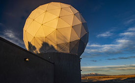
Ground antenna at Schriever Air Force Base, home of the 50th Space Wing. (Photo: Raytheon)

Ground antenna at Schriever Air Force Base, home of the 50th Space Wing. (Photo: Raytheon)

GPS ground stations that are contracted by Raytheon Technologies to replace the current ground stations are more than seven years behind schedule and lawmakers are not happy, reported Defense One. This delay has caused the U.S. Department of Defense (DOD) to go over its yearly budget and has sparked discussions as to future budget allocations for the U.S. Space Force (USSF) to continue to control and enhance the GPS constellation.

The USSF has been working to replace the current GPS ground stations with the GPS Next Generation Operational Control Segment (OCX) program since 2016. The operation was first delayed when the COVID-19 pandemic swept the world.

The additional delay was caused by efforts to replace IBM as the OCX hardware supplier after IBM sold its server product line to the Chinese company, Lenovo. The Pentagon believed the OCX program would be at a high risk for Chinese hacking after the sale to Lenovo, and in response, the contract with Raytheon was modified to replace the hardware with HP in 2020.

All of the delays have come at a cost, as the replacement of ground control stations has increased from $4 billion to $7 billion — a 73% increase over the original estimate — which was reported by a Government Accountability Office report in June.

Lawmakers wrote in the 2024 DOD appropriations bill, “[t]he fiscal year 2024 President’s budget request for the Space Force is $30,197,634,000, an increase of $3,907,806,000 or 15[%] over last year’s enacted level, continuing a trend of double digit growth over the past several years… [h]owever, despite these significant increases, the budget request continues to include serious shortfalls and disconnects.”

The USSF operates 32 GPS satellites, including six of the expected 10 next-generation GPS III satellites. However, some of the new satellites’ capabilities, including increased jamming resistance, can only be used once OCX comes online.

The lawmakers shared their displeasure with the OCX program delay, “[t]his is unacceptable and demands senior leader attention to ensure the program has the appropriate resources to complete OCX development and deliver the capability as soon as possible. The Committee remains concerned by other poor performing programs including Space Command and Control, Family of Advanced Beyond-line-of-site Terminals, Military GPS User Equipment Increment 1, and Enterprise Ground Services.”

Publicerad den Lämna en kommentar

Allies send new UAVs to Ukraine

Image: sandsun/iStock / Getty Images Plus/Getty Images

Image: sandsun/iStock / Getty Images Plus/Getty Images

Ukraine’s allies in Europe are sending the country new UAVs and counter-UAV equipment, reported The Defense Post.

German weapons provider Rheinmetall is preparing to send its LUNA NG (next generation) unmanned reconnaissance UAV to Kyiv, the company announced August 14. The system should be delivered by the end of the year, according to Rheinmetall.

The LUNA NG is part of a sizable military aid package for Ukraine initiated by the German government in July. Per Rheinmetall, the package includes a ground control station and several UAVs, as well as a launch catapult, an optional net equipment for catching landing UAVs and equipment for rapid repair. The system is mounted on a Rheinmetall HX truck with a swap body system.

The UAV is designed for a range of mission-specific payloads — including LTE network and electronic warfare support measures such as detection, classification and analysis of electromagnetic radiation for threat detection.

UAV can remain aloft for more than 12 hours and maintain a datalink range of up to 100 kilometers normally, and up to 300 kilometers when fitted with optional satellite communication equipment, according to Rheinmetall.

The Bundeswehr (the German military) has operated LUNA UAV systems since the early 2000s. Those were originally developed by German manufacturer EMT Penzberg, which was acquired by Rheinmetall in 2021.

Berlin has already delivered several reconnaissance UAVs to Ukraine, including 88 Vector UAVs from Quantum Systems, 20 RQ-35 Heidrun systems Sky-Watch, and 32 unspecified reconnaissance UAVs, as of August 9.

Ukraine will also soon receive a series of Cortex Typhon counter-UAV systems made by Norway’s Kongsberg, after the company signed an agreement via the International Fund for Ukraine.

The delivery consists of several Cortex Typhon systems — developed to counter a wide spectrum of UAVs with solutions to either physically harm or disable an aerial threat, Kongsberg said.

Publicerad den Lämna en kommentar

Faux signals for real results: Racelogic

An exclusive interview with Julian Thomas, managing director, Racelogic. For more exclusive interviews from this cover story, click here.


In which markets and/or applications do you specialize?

We originally designed our LabSat simulator for ourselves, because we supply GPS equipment to the automotive market. Then, we decided to sell it into that market, which is our primary market, for other people to use. That’s where we started, but it has moved on since then. We supply many of the automotive companies who use it for testing their in-car GPS-based navigation systems.

However, we’ve moved on to our second biggest market, which is the companies that make deployment systems for internet satellites, which use it for end-of-life testing. Several of our customers use it. That’s because we do space simulations, so we can simulate the orbits of satellites. That’s very useful when they’re developing their satellites.

We supply many of the major GPS board manufacturers — such as NovAtel, Garmin, and Trimble — when they’re developing their boards and testing their devices. We supply many of the phone companies — such as Apple and Samsung — and many of the GPS chip manufacturers — such as Qualcomm, Broadcom, and Unicom. More or less any company that’s into GNSS.

How has the need for simulation changed in the past five years, with the completion of the BeiDou and Galileo GNSS constellations, the rise in jamming and spoofing threats, the sharp increase in corrections services, and the advent of new LEO-based PNT services?

It all started off very simple, with just GPS, which was one signal and one frequency. We got that up and working very well and it helped us a lot. Then we got into this market. In the last few years, we’ve had to suddenly invent 15 new signals. We do two systems, really: one is a record-and-replay system. You put a box in a car, on a bike, in a backpack, or on a rocket, and you record the raw GPS signals; then you can replay those on the bench. That requires greater bandwidth, greater bit depth, smaller size, battery power, all of that.

The other is pure signal simulation. We simulate the signals coming from the satellites from pure principles. So, we’ve had to dive into how those signals are structured, reproduce them mathematically, and then incorporate that in into our software. That’s been 15 times the original work we thought it would be, but as we add each signal it tends to get a bit simpler until they add new ways to encode signals, and then it gets complex again. We’ve had to increase our bandwidth, increase our bit depth for the recording to cover all of these new signals.
Because our systems record and replay, they’re used a lot to record real-world jamming. In many scenarios, our customers will take one of our boxes into the field and record either deliberate jamming or jamming that’s been carried out by a third party. Then they can replay that in the comfort of their lab.

With regards to spoofing, we’ve just improved our signal simulation. So, we can completely synchronize it with real time. We can do seamless takeover of a GNSS signal in real time. We can reproduce the current ephemeris and almanac. If we transmit a sufficiently powerful signal, we can completely take over that device. Then we can insert a new trajectory into it. That’s a very recent update we’ve done.

If the complexity and amount of your work has gone up so much in the last few years but you cannot increase your prices at the same rate, what does that do to your business model?

It’s the same people that produce the signals in the first place, so they still have a job. However, as we add more signals and capabilities, we tend to get more customers as well.

Oh, so, you’re expanding your market!

Right, right.

Regarding some of the new PNT services being developed, how do you simulate them realistically without the benefit of recordings of live sky signals?

It is all pure signals simulation. You go through the ICD line-by-line and work out the new schemes. Here’s an interesting anecdote. Our developer who does a lot of the signal development is Polish and is also fluent in Russian. When we were developing the GLONASS signals, he was working from the English version of the GLONASS ICD. He said that it didn’t make any sense. So, he looked at the Russian version and discovered that the English one had a typo. When he used the Russian version, everything worked perfectly. He told this to his contacts at GLONASS and they thanked him and updated the English translation of their document. So, you are very, very much reliant on every single word in that ICD.

Are there typically differences between the published ICD and the actual signal?

No, no. Apart from the Russian one, which had a typo, they’re very good. For example, we’ve recently implemented the latest GPS L1C signal. My developer spent six months recreating it and getting all the maths right and the only way you could test it was to connect it to a receiver and hit “go.” It just worked the first time. He almost fell off his chair. The ICD in that case was very, very accurate.

Hope that Xona’s ICD is just as good.

Yeah.

Are accuracy requirements for simulation increasing, to enable emerging applications?

Yes, absolutely. No one can have too much accuracy. Everyone’s chasing the goal of getting smaller, faster, and more accurate systems. They want greater precision and better accuracy from their simulators, as well as a faster response. We do real-time simulators and they want a smaller and smaller delay from when you input the trajectory to when you get the output. Luckily for us, Moore’s law is still in effect, so, as the complexity of the signals and the accuracy requirements increase, computers can churn through more data. Luckily, we’re able to keep up on the hardware side as well, because much of our processing is done using software. Some companies do it in hardware and some companies do it in software. We concentrate on the software side of things.

Here’s another interesting anecdote from my Polish guy. He noticed that the latest Intel chips contain an instruction that multiplies and divides at the same time but that it wasn’t available in Windows. So, he put in a request with Microsoft for that operational code and they incorporated it into the very latest version of dotnet, which has improved our simulation time by 7%. I see little improvements like that all the time.

Are all your simulators for use in the lab or are some for use in the field? If the latter, for what applications and how do they differ from the ones in the lab? (Well, for starters, I assume that they are smaller, lighter, and less power-hungry…)

All our systems are designed to be used inside and outside the lab. They can all be carried in a backpack, on a push bike, in a car. We do that deliberately, because we come from the automotive side of things, so we have to keep everything very small and compact.

Besides automotive, what are some field uses?

Some of our customers have put them in rockets, recording the signal as it goes up, or in boats. We have people walking around with an antenna on their wrist connected to one of our systems, so that they can simulate smartwatches. There are many portable applications. We have a very small battery-powered version, which makes it very independent.

Are there any recent success stories that you are at liberty to discuss?

Our most exciting one is a seamless transition for simulation that we developed to replace or augment GPS in tunnels. We’ve been talking to many cities around the world that are building new tunnels. Because modern cars automatically call emergency services when they crash or deploy their airbags, they need to know where they are, of course. Cities need to take this into account when they are building new tunnels, which can pass over each other or match the routes of surface streets. Therefore, accurate 3D positioning in the tunnels has become essential. It requires installing repeaters every 30 meters along each tunnel and software that runs on a server and seamlessly updates your position every 30 meters. As you enter a tunnel, your phone or car navigation system instantly switches to this system. It’s been received very well because it’s mainly software and the hardware is pretty simple. We’ve brought the cost down to a fifth of the cost of standard GPS simulators for tunnels. So, we’re talking to several cities about some very long tunnels, which is very exciting.

Publicerad den Lämna en kommentar

OGC and partners release marine SDI roadmap

Image: OGC

Image: OGC

The Open Geospatial Consortium (OGC) has released the first iteration the Integrated Geospatial Information Framework (IGIF)-M (Marine) Spatial Data Infrastructure (SDI) Maturity Roadmap for both marine and terrestrial domains.

Developed as part of OGC’s ongoing Federated Marine Spatial Data Infrastructure (FMSDI) Initiative, the IGIF-(M)SDI Maturity Roadmap is a quick-start guide for nations and marine organizations aiming to advance and simplify efforts in marine SDI while ensuring alignment with the UN-IGIF principles.

“The IGIF-MSDI maturity roadmap is an important step that supports a holistic understanding of data-exchange and processing environments,” said OGC Chief Technology Innovation Officer, Ingo Simonis.

According to the OGC, the core of the IGIF-(M)SDI Maturity Roadmap is formed by the World Bank SDI Diagnostic Toolkit where, with contributions from IHO and OGC, its terrestrial heritage was augmented to maximize its benefits to the marine domain.

The roadmap and related resources are available for free on OGC’s IGIF-(M)SDI Maturity Roadmap website. 

Feedback and applied experiences from the geospatial community are sought via OGC Member Meetings or directly.

Publicerad den Lämna en kommentar

u-blox and ORBCOMM partner for integrated IoT communications

Image: metamorworks/iStock/Getty Images Plus/Getty Images

Image: metamorworks/iStock/Getty Images Plus/Getty Images

u-blox has partnered with ORBCOMM, a pioneer in Internet of Things (IoT) technology, to develop solutions for the convergence of terrestrial and satellite IoT communications markets.

According to the Ericsson Mobility Report, the number of cellular IoT connections is projected to reach around 5.5 billion by 2028. The satellite IoT communications market is also expected to triple by 2025. Combining these two technologies will provide gap-free global connectivity for IoT communications, even in previously uncovered areas, making it more accessible for IoT deployers.

With this partnership, u-blox will integrate ORBCOMM’s satellite communication protocols into its UBX-R52/S52 LPWA (low-power wide-area) modem SoC (system-on-a-chip) resulting in a smaller, less complex chipset that offers dual connectivity. This chipset will be used in future u-blox module products, enabling connected solutions across the globe.

The collaboration between ORBCOMM and u-blox will meet the increasing demand for IoT solutions capable of connecting devices in remote locations, areas with poor cellular coverage and isolated environments. Various industrial IoT applications can benefit from these solutions, such as asset tracking, equipment tracking in agriculture and construction industries, and industrial sensors.

“Pairing ORBCOMM’s satellite technology with u-blox’s innovative UBX-R52/S52 chipset will allow customers deploying IoT solutions in the supply chain, heavy equipment, and agriculture industries to benefit from ubiquitous coverage, device simplicity, along with optimal reliability and longevity,” said David Roscoe, ORBCOMM’s executive vice president of satellite communications and products.

Publicerad den Lämna en kommentar

First Fix: Satellites and spacetime

Matteo Luccio

Matteo Luccio

Sitting comfortably in a thin aluminum tube at 35,000 ft, I can continue to communicate via e-mail — and, soon, via video — and write this editorial, while on my way from Portland, Oregon, where I live, to Cleveland, Ohio, where North Coast Media, this magazine’s publisher, is based.

I can safely assume that the pilot knows our position, heading, and speed with great accuracy and receives excellent weather reports. The computer on my wrist (made by the largest manufacturer of GNSS-based consumer devices) and the much more powerful one in the holster on my belt, can do way more than Dick Tracy’s creator, Chester Gould, could have ever imagined a gadget produced by Diet Smith Industries to do.

One thing that communications, navigation, and weather forecasts currently share is reliance on satellites — be they in geostationary Earth orbit (GEO), at 22,000 mi, which are used mostly for weather data, broadcast television and, increasingly, data communication; medium Earth orbit (MEO), at 3,000 mi to 12,000 mi, including GNSS satellites and those that provide Internet connectivity; or low-Earth orbit (LEO), 300 mi to 745 mi, with thousands of satellites in operation today, primarily addressing science, imaging, and low-bandwidth telecommunications needs — and, coming, a new generation of satellite-based positioning, navigation, and timing (PNT) services.

Another thing these feats of engineering share is their foundation on the purest science and mathematics. To take one example, had the designers of GPS failed to adjust the system by 38 ms per day to account for both Albert Einstein’s 1905 Special Theory of Relativity and his 1915 General Theory of Relativity, positional errors would cumulate at a rate of about 6.2 mi each day, making GPS utterly worthless for navigation in a very short time. That’s because Einstein’s 1905 theory leads to the prediction that the atomic clocks on GPS satellites should fall behind clocks on the ground by about 7 ms per day because of their slower ticking rate due to the time dilation effect of their relative motion — while his 1915 theory leads to the prediction that they would be ticking faster than identical clocks on the ground by 45 ms per day due to the curvature of spacetime.

As with most complex technologies, the scientific principles, technical challenges, and policy debates behind GNSS are unknown and irrelevant to more than 99% of the public, few of whom even know that GPS is not the only global navigation satellite system in existence today. The technology is transparent to them. Most of them say “GPS” to refer to GNSS receivers, digital maps, driving directions and traffic data without understanding the separate, though overlapping, technologies, business models and data sources involved. This routinely results in misunderstandings and misattributed complaints and praises — such as when drivers blame “their GPS” (meaning their GPS receiver) for leading them up a dead end that was due to a mapping company being one step behind new construction or praise it for traffic alerts for which they should thank crowd-sourced data and algorithms.

Matteo Luccio | Editor-in-Chief
mluccio@northcoastmedia.net

Publicerad den Lämna en kommentar

Mars Laser RTK released for surveying and mapping

Image: ComNav Technology

Image: ComNav Technology

ComNav Technology has released the second product of its Universe series of GNSS receivers, the Mars Laser RTK real-time kinematic (RTK). The Mars Laser RTK is suitable for surveying, mapping, and geographic information system applications.

The Mars Laser RTK features a datalink modem that transmits and receives across the full frequency range from 410 MHz to 470 MHz. With adjustable transmit power of 0.5 w to 2 w and a maximum distance of 15 km, it meets the measurement demands of complex environments. It can also switch roles between a rover and a base, enabling more flexibility in demanding applications.

The Mars Laser RTK is equipped with a Wi-Fi/4G modem and Bluetooth capabilities, facilitating reliable communication across various platforms. The device also features five LEDs on the front panel for satellite tracking, RTK corrections data and more.

Powered by the SinoGNSS K8 high precision module, the Mars Laser RTK supports full-constellation and multi-frequency tracking, including GPS, GLONASS, BDS, QZSS, IRNSS, and Galileo, and supports precise-point positioning service. Additionally, the device tracks more than 60 satellites and 1,590 channels.

The Mars Laser RTK’s third-generation inertial measurement unit (IMU) supports 60° tilt with 2.5 cm accuracy. The IMU can be set to both traditional mode with range pole and laser mode.

The Mars Laser RTK is available now.

Publicerad den Lämna en kommentar

The world is on fire: Fire strikes Maui

Satellite images taken on June 25 and August 9 show an overview of southern Lahaina, Hawaii, before and after the recent wildfires. (Image: Maxar Technologies)

Satellite images taken on June 25 and August 9 show an overview of southern Lahaina, Hawaii, before and after the recent wildfires. (Image: Maxar Technologies)

The number of wildfires this year only increases as the island of Maui, Hawaii has been struck by several wind-whipped wildfires fueled by Hurricane Dora. Flames engulfed parts of Hawaii the morning of Wednesday, August 9, destroying a centuries-old town and killing at least 36 people, reported NBC News.

The fires took people on the island by surprise on Tuesday, as it left behind burned-out cars on once busy streets and smoking piles of debris where historic buildings once stood. Residents and tourists were forced to evacuate the area – including some who reportedly jumped into the ocean to escape the flames.

The National Weather Service believes the combination of high winds and low humidity is what caused the dangerous fire conditions across the island.

On Wednesday, a series of maps from NASA’s Fire Information for Resource Management System were released, highlighting the number of wildfires still burning on the island.

Satellite images also were taken, showing hundreds of shops and homes burned to the ground. The satellite images focus on the historic Lahaina area, which dates to the 1700s and has long been a popular tourist destination rich with native Hawaiian culture.

In one image from Maxar Technologies, the historic area of Banyan Court in Lahaina appears to have been mostly reduced to ash. Some 271 structures were damaged or destroyed, the Honolulu Star-Advertiser reported, citing official reports from flyovers conducted by the U.S. Civil Air Patrol and the Maui Fire Department.

The fires in Maui come after scientists have warned that wildfires are becoming more frequent and more widespread across the globe.

Rising global temperatures and the increased extreme weather has led to a surge in the number of wildfires rapidly consuming extensive areas of vegetation and forested lands. Wildfires have recently spread across Greece, Italy, Spain, Portugal, Algeria, Tunisia and Canada — resulting in mass environmental and economic damage as well as human casualties.

Publicerad den Lämna en kommentar

ProStar, Leica Geosystems announce technology integration

ProStar Holdings Inc., a precision mapping company, has announced a technology integration with Leica Geosystems, part of Hexagon. The integration combines ProStar’s utility mapping software, PointMan, and Leica Geosystems’ precision GPS/GNSS receivers for GIS asset data collection.

The integration provides a precise and comprehensive data collection solution to capture, record and display the precise location of critical underground infrastructure across the globe using Leica Geosystems receivers.

“It only makes good business sense to work with other software providers and create mutually beneficial business relationships throughout the geospatial industry,” said Jason Hooten, GIS sales and support manager, Leica Geosystems.

Through the technology integration, PointMan now supports Leica Geosystems receivers for mobile devices running the Google Android operating system and Apple iOS, including the popular Zeno FLX100 plus GNSS receiver.

“The relationship adds significant value to our distribution network as Leica is recognized as a global leader in providing utility data collection solutions and precision GNSS receivers,” said Page Tucker, CEO of ProStar.

ProStar’s PointMan is natively cloud and mobile, offered as a Software as a Solution (SaaS). ProStar’s solutions are being adopted by some of the largest entities in North America, including Fortune 500 construction firms, the largest subsurface utilities engineering (SUE) firms, and government agencies.