Publicerad den Lämna en kommentar

Position Partners, Teleo partner on autonomous heavy equipment technology

Image: Teleo

Image: Teleo

Position Partners has entered an agreement to partner with Teleo, a U.S. based company building autonomous technology for heavy equipment. Under the agreement, Position Partners will offer the full Teleo remote-operated and autonomous solutions across Australia, New Zealand and Southeast Asia.

Teleo’s system can be modified to any make and model of machine and includes the company’s proprietary software, a remote command center to operate the equipment, and a mesh network to enable two-way communication between the command center and machines.

The system incorporates sensors, including high dynamic range cameras that deliver high-definition visibility and video footage both day and night.

Once Teleo’s technology is integrated, users can control multiple machines, at multiple sites, from a single station.

“With ongoing labour and skills shortages in the construction sector, there is more work to be done than there are people to do it,” Position Partners CEO Martin Nix said.

Position Partners will offer the full Teleo solution to customers and support sales, installation and training in all countries in which the company operates including Australia, New Zealand, Singapore, Indonesia, Malaysia and the Philippines.

Publicerad den Lämna en kommentar

Adtran timing module receives OCP-TAP approval

Image: Adtran

Image: Adtran

Adtran’s OSA 5400 TimeCard has obtained approval from the Open Compute Project (OCP) Time Appliance Project (TAP) for data center timing and synchronization. The plug-in device integrates Adtran’s Oscilloquartz timing technology into any white box server, aiming to solve key challenges in the transition to virtualized environments.

The OSA 5400 TimeCard facilitates smooth and efficient operations for critical and time-sensitive applications. The card’s compact design, scalability and advanced features make it ideal for data center operators looking to adopt open, disaggregated hardware, the company said.

In combination with Adtran’s Ensemble Sync Director, the timecard offers operational teams a comprehensive, unified view of their entire timing infrastructure. Additionally, the OSA 5400 TimeCard has been developed to fully align with the IEEE P3335 standardization. The inclusion of high-performance quartz and rubidium oscillators ensures accurate timing during extended GNSS disturbances.

The OSA 5400 TimeCard can be integrated into available PCIe slots of standard servers or PCs.

Publicerad den Lämna en kommentar

TRX Systems DAPS GEN II system now shipping to U.S. Army

Image: TRX Systems

Image: TRX Systems

TRX Systems has announced it is now shipping the Dismounted Assured Positioning, Navigation, and Timing (PNT) System Generation II (DAPS GEN II) solution to the United States Army. The device provides assured PNT to warfighters operating in GPS-denied environments. 

In March, the U.S. Army Program Executive Office for Intelligence, Electronic Warfare and Sensors awarded TRX a seven-year, $402 million contract to deliver the DAPS GEN II systems 

TRX DAPS GEN II is a small, handheld device that features efficient power utilization algorithms that enable a continuous stream of assured PNT data for warfighters and their combat systems. To achieve this, the device fuses inputs from a diverse range of PNT sources including M-code GPS, a secure and higher-powered military GPS capability that is resilient against jamming and other threats, complementary sources of position and time data when GPS is degraded, and inertial sensors supporting integrity and positioning, independent of any satellite source. 

The TRX DAPS II system is available for purchase by U.S. government entities. Distribution to U.S. allies is restricted to approved cases in the Foreign Military Sales Program. 

Publicerad den Lämna en kommentar

UK government PNT plan focuses on policy, timing center, eLoran, defense time and SBAS

Image: RistoArnaudov/E+/Getty Images

Image: RistoArnaudov/E+/Getty Images

The United Kingdom’s Minister for Science, Research, Innovation announced in Parliament today a 10 point “policy framework” for advancing positioning, navigation, and timing (PNT).

The announcement addressed improvements to both PNT technology and policy. 

Six technology efforts were listed:  

  • “National Timing Centre: develop a proposal for a National Timing Centre (NTC) to provide resilient, terrestrial, sovereign, and high-quality timing for the UK (UTC(NPL)), including sovereign components and optical clocks.” This project has been underway for some time and is being executed by the UK’s National Physical Laboratory. The announcement said another £14 million had been identified and was being allocated to the project. 
  • “MOD Time: develop a proposal for ‘MOD Time’ creating deeper resilience through a system of last resort and use NTC provided timing to support MOD.”  
  • “eLORAN: develop a proposal for a resilient, terrestrial, and sovereign Enhanced Long-Range Navigation (eLORAN) system to provide backup position and navigation.” In May, the UK’s spectrum office, Ofcom, sought interest from industry in obtaining eLoran broadcast licenses. The U.S. Department of Transportation issued a similar request for information this month.  
  • “UK SBAS: develop a proposal for a UK Precise Point Positioning Satellite-Based Augmentation System (SBAS-PPP) to replace the UK’s use of the European Geostationary Navigation Overlay Service (EGNOS), monitor GNSS and enable GNSS-dependent high accuracy position for autonomous and precision uses.” Since Brexit, the UK has not been a part of the EU’s Galileo enterprise. This SBAS decision comes after the UK government researched and rejected the idea of establishing its own GNSS. 
  • “Next Generation PNT: deploy existing R&D funding into a UK Quantum Navigator and investigate possible options for a UK sovereign regional satellite system.” Britain has made development of quantum capabilities, including PNT, a particular national focus. 
  • “Infrastructure Resilience: rollout resilient GNSS receiver chips, develop holdover clocks, and consider options for legislation on CNI sectors to require minimum resilient PNT.” The U.S. Executive Order 13905 points in a similar direction as this idea for legislation, which is a good segway to the announcement’s policy provisions. 

Four organizational and policy initiatives included in today’s statement in Parliament: 

  • “National PNT Office: establish a National PNT Office in the Department of Science, Innovation and Technology to improve resilience and drive growth with responsibility for PNT policy, coordination, and delivery.” Last year the Resilient Navigation and Timing Foundation reported a cross-government office had been established by the UK that included representation from the Ministry of Defence. That office was within the Department for Business, Energy & Industrial Strategy (BEIS). Since then, BEIS has been split into two departments, one of which is Science, Innovation, and Technology.  
  • “PNT Crisis Plan: retain and update a cross-government PNT crisis plan to be activated if GNSS-provided PNT is lost and identify and implement short term mitigations.” Similar plans exist in the United States. The absence of an interference detection and monitoring system, though, has helped stymie U.S. government efforts to respond quickly and effectively. 
  • “PNT Skills: explore options for centers for doctoral training in timing and PNT and review PNT skills, education, and training for longterm sovereign PNT capability.” A similar need has been identified by the U.S. President’s National Space-based PNT Advisory Board. 
  • “Growth Policy: develop a PNT growth policy, including R&D programs, standards and testing, to drive innovation for PNT based productivity.” The U.S. PNT R&D Plan is a similar effort. 

Also mentioned in the statement to parliament are two new PNT documents published today by the UK Space Agency. The first is a summary of technical concepts developed under the Space Based PNT Programme. The second is an updated report on the economic impact to the UK of a disruption to GNSS.  

Both documents should be available in the House of Commons Library shortly. 

Publicerad den Lämna en kommentar

GPS jamming in Israel

Just as I was beginning to write this article, war broke out between Israel and terrorist forces in Gaza. It would seem that the rockets used by Gaza were aimed rather than carrying on-board guidance, while Israeli airforce bomb/rocket attacks have been carried out with some degree of precision. Nevertheless, jamming in Israel may still be relevant to the ongoing conflict and any on-going commercial aircraft activity. However, it seems from the diagram of jamming below, that the Gaza strip is virtually interference free.

One of the things you can be sure of in the Ukraine-Russia war is that one side or the other is jamming the other’s communications and sat-nav guidance systems. An apparent consequence is that there is likely some “spill-over” to adjacent areas. For Israel, however, it looks like it’s more directed jamming rather than incidental.

Israel GPS jamming. (Image: GPS Jam.org)

Israel GPS jamming. (Image: GPS Jam.org)

In this environment of intentional GPS jamming, it’s not surprising that Israel has produced a leading anti-jam technology company, called InfiniDome, in Caesarea (between Haifa and Tel-Aviv). According to co-founder Omer Sharar, the company has been working to defend GPS signals for more than seven years and has also seen the rise of devices to jam the GPS L1 frequency that anyone can buy online for $100.  

 Just as Ukraine is throwing explosive cardboard UAVs with little cost at Russian occupying forces, a few carefully placed low-cost jammers could inflict serious damage on a country’s navigation capabilities. 

 However, a 2019 presentation by Todd Humphreys identified the source of interference and spoofing at that time, a Russian high-power jammer located at a Russian base in Syria. 

Humphreys used instrumentation on the International Space Station (ISS) to gather data on the directed interference but concluded that the jamming in Israel could be a consequence of Russia’s efforts to protect its troops in Syria from UAV attacks. The Russian Khmeimim Air Base is on the Mediterranean coast and attacks are thought to come from rebels within Syria.

With the current GPS jamming out of Syria, most commercial aircraft traffic flying into Ben Gurion International Airport is significantly affected as flights cross from over the coast from the Mediterranean. Longer flight tracks deeper southeast into Israel are necessary, probably relying on VOR and DME ground station waypoints before turning back northwest to capture the instrument landing system (ILS) into the airport. This costs time and fuel and causes aircraft to overfly settlements where noise can be a real problem.

Most readily available jammer electronics only output interference disrupting GPS L1, which is most commonly installed for vehicle tracking and UAV guidance. InfiniDome has successfully protected trucking, UAV operations and others in Israel and around the world with its Infinidome GPSdome-1 and GPSdome-2 anti-jam products.

Gpsdome-1 (left) protects GPS L1. GPSdome-2 (right) protects GPS L1/L2 or GPS L1/GLONASS L1.

Gpsdome-1 (left) protects GPS L1. GPSdome-2 (right) protects GPS L1/L2 or GPS L1/GLONASS L1.

Two antennas 10 cm to 25 cm apart enable GPSDome-1 algorithms to detect and null out a GPS L1 jammer. GPSDome-2 accommodates up to four antennas and can null up to three directional signals on both GPS L1 and L2 or GPS L1 and GLONASS L1. 

InfiniDome is currently working with an aerospace company to integrate its anti-jam technology with airborne inertial/GPS and qualify the integrated system for use in civil aviation, with the objective of maintaining max 3% drift when fully jammed. This will introduce certified anti-jam technology into civil aviation use — something that will provide some jamming protection, which airlines desperately need going forward. In addition, other high-end UAV manufacturers are potential customers for this new system. 

While the ongoing conflict and the devastating loss of life is forefront as each day of the war passes, these anti-jam solutions may ultimately help solve signal degradation problems. While there is going to be a significant impact on commercial airline travel to and from Israel while hostilities continue, we can maybe see the way to a possible long-term solution for the intense jamming from which the region has suffered for many years. 

Publicerad den Lämna en kommentar

GMV provides vehicle positioning solution to BMW

Image: BMW Group

Image: BMW Group

GMV has been selected by BMW Group to supply its safe and precise positioning technology, GMV GSharp, for the next generation of BMW Group’s autonomous vehicles.

GSharp is equipped with an onboard positioning engine (PE) software and a GNSS corrections service, allowing vehicles to collect augmentation data and safety-related information for computing an accurate and reliable user position.

Both the correction service and positioning engine are developed following the ISO 26262 and ISO 21448 standards to ensure compliance with safety requirements. The solution also complies with the concept of security-from-design as per ISO 21434, including the necessary counter-measures in the SW and system and in the GNSS related attack detection or anti-spoofing and anti-jamming schemes.

The most demanding automotive project management practices and industry standards for software engineering (A-SPICE CL3) have been applied during its development.

In addition to the software side, GMV’s solution relies on a secure and redundant physical infrastructure. GMV owns and operates a worldwide GNSS station network, which provides the GNSS raw data needed to generate the corrections. These corrections are computed within two physically independent data centers, providing GMV’s solution the required availability levels for automated driving applications.

Publicerad den Lämna en kommentar

Leica Geosystems develops first-person laser scanner

Image: Leica Geosystems

Image: Leica Geosystems

Leica Geosystems, part of Hexagon has developed the Leica BLK2GO PULSE, its first-person laser scanner that combines lidar sensor technology with the original Leica BLK2GO form factor. The technology is set to be released in early 2024.  

The scanner offers users a rapid, simple and intuitive first-person scanning method that can be controlled with a smartphone, and delivers full-color 3D point clouds instantly in the field.

The BLK2GO PULSE was built in collaboration with Sony Semiconductor Solutions Corporation to combine Sony’s advanced time-of-flight (ToF) image sensors with Leica Geosystems’ GrandSLAM technology, resulting in a dual ToF handheld scanner.

The product is designed for indoor applications such as the creation of 3D digital twins and 2D floor plans. It includes first-person scanning capabilities and instant data availability, allowing users to immediately download, view and share colorized 3D point clouds and images from the field.  Scans can then be uploaded to Reality Cloud Studio, Hexagon’s cloud application for reality capture data visualization, collaboration and storage.  

Publicerad den Lämna en kommentar

Launchpad: Mobile mapping, antennas and GNSS receivers

A roundup of recent products in the GNSS and inertial positioning industry from the October 2023 issue of GPS World magazine.


SURVEYING & MAPPING

GNSS Receiver
For GIS and survey professionals

The R2 GNSS system is a compact, durable, and flexible GNSS receiver that collects highly accurate data in a wide range of geospatial applications with submeter to centimeter positioning accuracy. The R2 can track the full range of GNSS satellite constellations and augmentation systems, and also comes with an integrated Trimble Maxwell 6 chip and 220 channels. Users can achieve higher accuracy in real-time with the ability to choose correction sources from traditional real-time kinematic, VRS networks, to Trimble RTX correction services delivered by both satellite and internet/cellular. The R2 can provide improvements to position availability and accuracy when heavy overhead cover, such as tree canopy and buildings, obstruct satellite signals. The receiver is also IP65-rated, making it suitable for rugged environments.
Trimble Geospatial, geospatial.trimble.comImage: Inertial Labs

Scanning and Mapping Solution
Designed for accuracy-focused remote sensing applications

The Resepi Teledyne Optech CL-360-HD has a powerful four-return laser and increased range of up to 750 m, making it ideal for mobile mapping, forestry and crack detection in critical infrastructure areas such as airport runways. Resepi is a sensor-fusion platform designed for accuracy-focused remote sensing applications. Resepi utilizes a high-performance INS and a high-accuracy dual antenna GNSS receiver, integrated with a Linux-based processing core and data-logging software. The platform also provides a Wi-Fi interface, optional imaging module, and external cellular modem for RTCM corrections. Resepi can be operated by a single hardware button or from a wirelessly connected device via a simple web interface. Resepi, equipped with Teledyne’s CL-360HD lidar, offers various laser scan speeds and frequencies, allowing users to tweak the settings to match their individual needs.
Inertial Labs, inertiallabs.com

Photo:

GNSS Receiver Series
Available in three different models for various applications

The Xtraordinary X1-series GNSS receivers include X1 and X1 Lite and X1 Pro. The X1-series adopts Linux OS, which improves the stability of the system and the synergistic compatibility of each module. This series of GNSS receivers features improvements to satellite tracking, the inertial measurement unit (IMU), battery life, and more. Optimized with a new generation of IMU module, users can easily initialize the IMU in 5-sec and start tilt measurements up to 60°. The X1-series GNSS receivers supports both 4G/radio correction data transmission and can reach up to 15 km range in enhanced internal UHF mode, 20 km range in external mode, and more than 50 km via internal GSM or PDA CORS mode.
SingularXYZ, singularxyz.com
Image: Hemisphere

GNSS Smart Antenna
For agricultural, marine, GIS, mapping and other applications

The A631 combines the Athena GNSS engine and Atlas L-band correction technologies with a new web user interface (WebUI). Optional features include 16 GB of internal storage, Bluetooth and Wi-Fi. The compact antenna is designed for rugged environments and meets IP67 requirements. With multiple operating modes, A631 can be used as an RTK base station or rover. The device is supported by the Atlas Portal, which empowers users to update firmware and enable functionality, including Atlas subscriptions for accuracies from meter to sub-decimeter levels. A631 also supports BaseLink and SmartLink modes. SmartLink allows users to directly connect AtlasLink as an extension to any existing system that has industry-standard connectivity options. BaseLink automatically sets up AtlasLink as a permanent reference station, delivering corrections to any other GNSS receiver being used for positioning.
Hemisphere GNSS, hemispheregnss.com

Photo:

GNSS Receiver
For land surveying, GIS, and construction applications

The Mars Pro combines GNSS, inertial measurement unit (IMU), and laser technologies. When set to laser mode, the Mars Pro can carry out measurements by selecting a signal-friendly spot within a 10-m radius, which aids in measuring hard-to-reach, signal-obstructed, and hazardous areas. With its millimeter-level laser distance meter integrated on its rear, the Mars Pro facilitates the utilization of the laser mode in scenarios involving surveying and stakeout. The integrated IMU sensor offers 60° tilt compensation, which remains functional even when operating in laser mode, allowing for uncompromised efficiency and accuracy. Equipped with the latest K8 platform, it boasts full-constellation support, offering 1,668 tracking channels and more than 60 satellite tracking capabilities across all existing and planned constellations — GPS, GLONASS, Galileo, BDS, QZSS and IRNSS. The Mars Pro offers support for precise point positioning (PPP) service, enabling rapid fixing within seconds. Its dynamic OLED color screen is sunlight readable and offers real-time visualization of essential data — satellite count, fixed state, on-off state, power, and more. It is compatible with mainstream brands and multiple protocols, such as Transparent, TT450S, SATEL, Trimtakl3, CHC and South.
ComNav Technology, comnavtech.com

Lidar System
For mobile mapping applications

The AlphaUni 20 lidar system (AU20) features advanced multi-target capabilities that support up to 16 target echoes for vegetation penetration. The AU20 captures ground surfaces with extreme precision, producing accurate digital elevation models and digital surface models in challenging environments. The lidar system has an accuracy of 2 cm to 5 cm. It has a lightweight, compact design that weighs 2.82 kg in its airborne configuration and a total of only 10.7 kg with its car mount kit, including a Ladybug5+. Its flexible multi-platform design allows users to install it on manned or unmanned aircraft for aerial scanning, integrate it into a variety of land vehicles, and even use it as a backpack-mounted system for mapping narrow areas.
CHC Navigation, chcnav.com

Image: Inertial Labs

Gyroscope
An advanced performance, tactical-grade MEMS gyroscope solution

Developed for use in particularly harsh environments, the TAG-304 gyroscopes can withstand extreme shock and vibrations in accordance with MIL-STD-810 standards. Additionally, TAG-304 gyroscopes are fully digitized (RS-422 interface), include built-in test (BIT) functionalities, and have no moving parts. TAG-304 is an advanced performance, tactical-grade MEMS gyroscope, of which size, power consumption, reliability and performance are ideal for accomplishing complex tasks requiring accurate stabilization of assorted platforms. Very low latency (group delay), small size, 4K Hz data rate, 1K Hz bandwidth, and low noise make TAG-304 gyroscopes a suitable solution for miniature electro-optical systems, gimbals, line-of-sight, and pan and tilt platforms stabilization and pointing applications.
Inertial Labs, inertiallabs.com

Image: ANELLO Photonics

IMU
For GNSS-challenged environments

The ANELLO IMU+ provides robust and reliable autonomous navigation and positioning in GNSS-denied or GNSS-compromised environments. Powered by optical gyroscope technology, the ANELLO IMU+ delivers high precision and reliability in demanding conditions, including shock, vibration, electromagnetic interference and temperature. The ANELLO IMU+ is suitable for autonomous applications in the construction, robotics, mining, trucking and defense industries.The device delivers long-term dead reckoning in high-temperature and high-vibration environments.The ANELLO IMU+ features unaided heading drift of < 0.5°/hr, dual high-speed CAN FD interfaces, and dual RS-232 interfaces; has ASIL-D ready, automotive-qualified CPU and OS; and is IP68 waterproof, resistant to dust, salt spray and chemicals.
ANELLO Photonics, anellophotonics.com

Image: Leica Geosystems

Flying Laser Scanner
Captures colorized 3D point clouds for producing 3D models, drawings, and visualizations

BLK2FLY is a fully integrated lidar UAV laser scanner with advanced obstacle avoidance for reality capture from the air. It can scan inaccessible areas such as rooftops, facades and large building interiors. BLK2FLY autonomously captures interior and exterior dimensions and features of buildings with a few taps on a tablet. Users can select an area within the map on their tablet and the BLK2FLY will create its own flight path to scan it quickly and safely. Users can send the BLK2FLY to scan a new area by tapping anywhere on the 3D view in the app. The BLK2FLY also can be piloted manually with virtual joysticks on a user’s tablet.

BLK2FLY can scan interiors of large arenas, stadiums, facilities, plants, and even obscured or confined outdoor areas with its Indoor Mode, which allows the BLK2FLY to get closer to objects with reduced flight speed and to fly within confined spaces without access to GNSS. With advanced obstacle avoidance and increased visual SLAM capabilities, the BLK2FLY’s Indoor Mode makes scanning inside fast and versatile.
Leica Geosystems, leica-geosystems.com


MOBILE
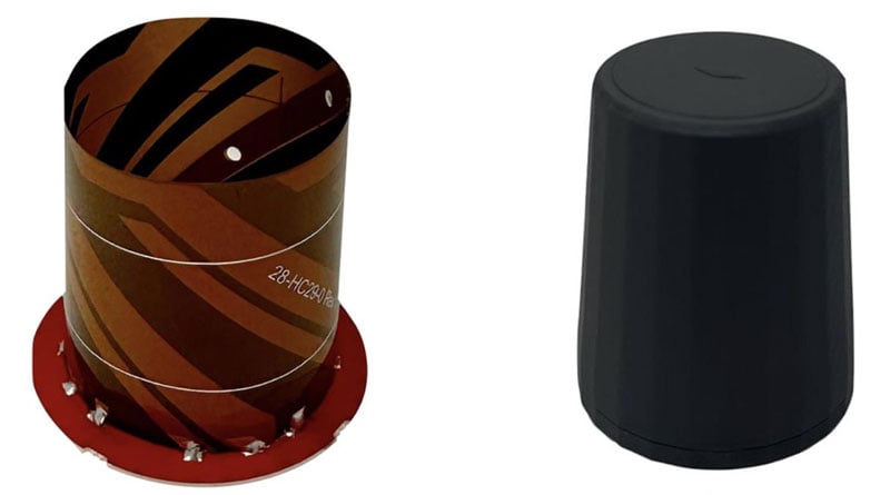
Image: Tallysman Wireless

Smart Antenna
Suitable for multiple applications

The HCS885XF/HCS885EXF smart helical GNSS antenna is suitable for UAV, land survey devices, automotive positioning, and other precise positioning/heading applications. The HCS885XF/HCS885EXF combines the performance and light weight of the Tallysman dual-band (GPS/QZSS L1/L5, GLONASS G1/G3, Galileo E1/E5a/b, BeiDou B1/B2/B2a) HC885SXF antenna with the low power consumption and GNSS augmentation capabilities of the u-blox NEO-F9P GNSS receiver. HCS885XF/HCS885EXF employs L5 signals (1160-1217 MHz), which transmit stronger signal power and a higher bandwidth chipping rate than L2 signals, thereby offering high performance when challenged with strong multipath signals. It also employs Tallysman’s eXtended Filtering system, which mitigates near-band and out-of-band interference, such as LTE signals and their harmonics and the planned Ligado service in North America, enabling operation in the most challenging deployments. The HCS885XF/HCS885EXF integrated receiver can simultaneously monitor four constellations, support base/rover RTK configurations (<1 cm), and use u-blox PointPerfect PPP-RTK augmented services over a terrestrial control network (3-6 cm). A moving-base precise heading configuration is available with base/rover antenna pairs.
Tallysman Wireless, tallysman.com

Image: Harxon

Antenna
Multi-constellation antenna for precision agriculture and semi-autonomous or autonomous applications

The TS122 EUAA provides centimeter-level accuracy in highly variable terrain and challenging GNSS-obstructed environments with ± 10 cm P2P accuracy and STANDALONE technology. The TS122 EUAA smart antenna receives dual-frequency multiple constellation signals from GPS, GLONASS, Galileo and BeiDou, with output position information up to 10 Hz. The antenna is capable of correcting deviations caused by a vehicle’s roll and pitch while working on uneven groups or slopes.
Harxon, harxon.com

Publicerad den Lämna en kommentar

CHCNAV launches aerial surveying solution

Image: CHCNAV

Image: CHCNAV

CHC Navigation (CHCNAV) has released the AlphaAir 10 (AA10), an advanced aerial surveying solution designed for UAV mapping and photogrammetry.

Leveraging CHCNAV’s lidar technology, the AA10 seamlessly integrates high-precision lidar, accurate GNSS positioning, IMU orientation and an industrial-grade full-frame orthophoto camera. Combined with CHCNAV point cloud and image fusion modeling software, this solution offers an efficient survey-grade approach to 3D data acquisition and processing.

The AlphaAir 10 can detect up to eight target echoes utilizing advanced multi-target capabilities, which greatly enhances its ability to penetrate dense vegetation and acquire precise ground surfaces.

Complementing the solution, the CoPre and CoProcess software suite streamlines post-processing and feature extraction with an easy-to-use and efficient data workflow. High-quality point cloud data is used to create a mesh model, followed by efficient 3D model reconstruction with realistic point cloud colorization using high-resolution image mapping textures.

In addition, the AA10 is IP64-rated, ensuring the system’s ruggedness and providing consistent, reliable performance in a wide range of operating conditions.

Publicerad den Lämna en kommentar

ANELLO adds to its optical-gyroscope based navigation systems

ANELLO Photonics has added real-time centimeter-accurate positioning and localization capabilities to its line of optical-gyroscope based navigation systems.

Its real-time centimeter accuracy is achieved by using real-time kinematic (RTK) correction data from GEODNET, a community-based decentralized network of over 3,000 GNSS reference stations worldwide.

Under the agreement, ANELLO Photonics users will have access to a free trial of RTK services and competitive options for long-term, high-volume correction data requirements.

By combining the ANELLO silicon photonics optical gyroscope (SiPhOG) with GEODNET’S global RTK correction network, users now have access to a new global cyber-infrastructure for reliable measurements.

The partnership offers users a combination of optical gyroscope technology and a reliable and global RTK correction network that enables centimeter-accuracy for industries operating in challenging RF and GNSS-denied environments. These environments include city centers, construction sites and orchards.

The agreement aims to address the challenging applications by using SiPhOG and its GNSS-denied dead-reckoning algorithms with GEODNET’s distributed global network of RTK stations. This combined technology offers high-level accuracy while reducing the total solution costs.

The companies aim to simplify performance intensive applications such as high-definition mapping and aerial or terrestrial autonomous vehicle deployment.

ANELLO is currently engaged in trials with users in the construction, farming, robotics, trucking, UAVs, autonomous vehicles, and defense space.